Showing posts with label Amador County. Show all posts

Wednesday, August 10, 2016

Around Kirkwood Lake

Kirkwood Lake

Date: September 6, 2015
Place: Kirkwood Lake, California
Coordinates: 38.701388, -120.076196
Length: 1.8 miles
Level: moderate

Usually when I make it to the Kirkwood area it is to experience the joys of winter wonderland. Last year, however, I had the opportunity to explore the area a little during summer. Last Labor Day weekend we went camping with friends near the Carson Pass and on one of the days there we hiked around Kirkwood Lake.
The lake isn't part of the ski resort but it is certainly a resort area. There is a campground at the western lake shore and a myriad of resort houses and cabins along the eastern and northern shores. The southern shore is left for some awesome wild granite cliffs.
There is a hiking trail surrounding the lake that is connected by a short path to Hwy 88. The trailhead is marked with a modest sign that is easy to miss unless looked for. There is a small pullout with a short dirt driveway where we parked the cars. We took our day packs, breathed in the hot summer air and set out for the hike.


It was almost mid-day by the time we got to the trailhead, and it was hot. It was difficult to get started but once we did we got into a steady pace and plunged into the woods.
I didn't expect to see any flowers this late in summer but I did see some late asters here and there wherever the sun got through the trees.

But generally, most plants had done blooming and were already fruiting.
California Mountain Ash (Sorbus californica)
Large, naked slabs of granite separated the forest trees, showing the mountain's making. Whenever we passed a particularly enticing one the children were all over it.

As short a distance as it was, it did feel like a long time before we arrived at Kirkwood Lake. We sat there for sometime, staring at the water. It was very hot, but there wasn't any good place there to go in the water, and no one suggested it anyway.
Kirkwood Lake
After a reasonable long break during which Papa Quail stalked and photographed a mockingbird we gathered ourselves and started the loop around the lake, counterclockwise.
Mockingbird
We made our way, single file, along a narrow path running between the waterfront and the rocks. The resort properties were stretching all the way down to the water and it wasn't clear to us whether we crossed any private property lines. One way or another, no one came out to say anything to us. In fact, we saw very little evidence that these houses had any residents at all.
What we did see was a quick movement in the grass. A call of excitement from the head of the line and I shot forward with my camera - quick enough to catch the tail of a dark snake as it slithered away into hiding.

The squirrels were less shy. Hopping here and there between the trees and over boulders and logs. One of them stopped for a brief pose.

Eventually we emerged from the trees and got a clear view of the southern shore across the lake. A high dome stood in the background, displaying two rock 'horns'. 

The water looked very inviting but when we finally arrived at the western edge of the lake where the campground was, everyone just slumped on the cement ledge there and zoned out.
The heat was intense. We had a long break at the western lake shore near the campground area. It took a while to get everyone back on their feet and down to the trail again.

The southern lake shore is mostly rocky slabs that go down all the way to the water. Hiking there involved climbing on the boulders and that got some life into the children who enjoyed hopping on the rocks. It was there also that we finally saw other people resorting by the lake. And where else would they be on such a hot day? So we had to take care not to step on anyone as we made our way between the rocky nooks.

There, hidden in the crevices, is also where I found some more bloom. Not a whole lot, but enough to cheer up the summer's dead heat.
Mountain Pride (Penstemon newberri)
The southern shore also didn't feel so hot. Or maybe it felt so because it was getting later in the afternoon. Either way, it seemed like our little group found renewed energies and now we were moving quickly.
But not too quickly to appreciate the wildflowers that were still on.
Western Eupatorium (Ageratina occidentalis)
The south shore trail rises at points high above the water but eventually descends down to the woods again and closes the loop that circumvents the lake. 
Pacific Red Elderberry (Sambucus racemosa var. racemosa)
Looking one more time at the lake. Despite the heat the eastern shores of Kirkwood Lake aren't very inviting for a swim. The shore vegetation is high and thorny and the water close to shore is muddy. Either way, my company were eager to go back to our campground, and so we looked at the water one last time and headed back east on the same path we cam in on.

The granite cliffs accompanied us along the trail as we started back toward the road. High and smooth. The trees that were sparse at first soon grew thick and we were engulfed by the forest.


After having led the hike all along I finally found myself bringing up the rear. That was good because I had the time to check out the plants and to find the last wildflower of the summer there.
Pearly Everlasting (Anaphalis margaritacea)
I was the only one who actually wanted to hike that day. Everyone else seemed contented for just hanging out by the lake where we camped. I insisted on getting everyone moving and now that they did, they were all eager to go back and have dinner. I looked wistfully back: it was the first time I paid attention to this area during the summer and it held much promise for future nature exploration. This little hike around Kirkwood Lake was merely the appetizer.


Friday, January 1, 2016

The Other Side of Kirkwood


Date: December 23, 2015
Place: Kirkwood Mountain Resort, California
Length: about 3 miles
Level: easy

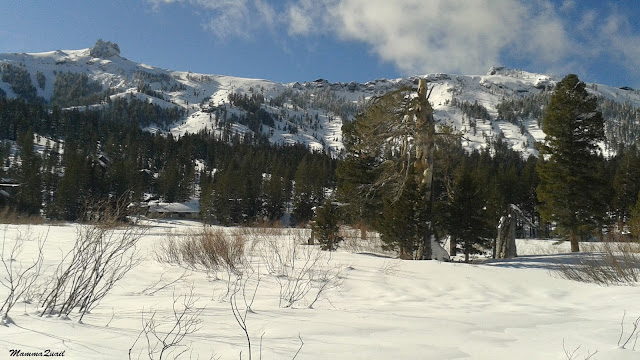
There is a loop trail that goes around the Kirkwood Meadow, just below the slopes. The trail might be visible in summer time too, I don't know. In winter, however, it is well marked on the snow, groomed to perfection for snow-shoe hikers and cross-country skiers.
I didn't plan to do this trail. I arrived at Kirkwood Mountain Resort with the intention to ski down hill. But it was a lovely day after three consecutive days of awful weather and many people had come to enjoy the fresh snow. After I dropped the chikas in ski school there was no more parking within the resort and the waiting line to get a lift pass was enormous. So I drove off to the cross-country lodge where I managed to find parking, and instead of marching all the way back with my skis I headed up to the lodge and rented me a pair of cross-country skis and boots, bought a trail pass for the day, and headed to the Meadow Trail.
So technically speaking, I didn't hike that trail. But cross-country ski is something I usually do when down-hill conditions are not to my liking and I never really built up the skill to be any good at it, so I skied at hiking speed, enjoyed the scenery very much and stopped frequently to take photos. (The photos here were all taken by my phone, please forgive their inferior quality).

The trail map I got said: 'The Other Side of Kirkwood'. It turned out to be a beautiful side.

The trail is very nicely groomed and is mostly flat, made for easy skiing. The temperature, however, was higher than optimal, making the snow more sticky and resistant. Still, I could glide easy enough on the trail. I hardly had to mind other skiers. There were so few out there.

The day I was there was the first clear day following a prolonged snow storm, The snow, so desperately needed there, had painted the trees in white. A very obvious line separate the trees that remained frosted the day after the storm.

The local conifers are evergreen and have a very nice contrast to the snow-whire slopes. The occasional bare tree is usually dead, but it too can look very beautiful as part of the winter scenery.

But not all bare plants are dead. The reddish twigs that stick out of the snow belong to willow shrubs, all dormant, sleeping the winter off.

Even when dormant the willows look pretty, reddish against the white snow background.
The creek was running still, deep in the snow. The trail bridges over the ice-cold stream.
Caples Creek
Dips, bumps, grass heaps, shrubs and gopher holes, all equally covered with a thick snow blanket, nicely quilt-patterned by the winds.

Slowly I made it to the far end of the meadow. I didn't take a backpack with me, and had no water or snack, so I crossed over to the resort's Village and entered the cafeteria. It was so crowded in there, the only place to sit was at the bar.
Oh, well.


After my break I waddled back to the meadow and somehow managed to hook on the skies again. I already learned that beer can affect my ski run choices, good thing that the meadow trail is flat. 
The cool air quickly cleared the alcohol fumes and I was on my way back north on the other side of the meadow. The clouds started gathering again and soon the sunlight dimmed. 


 By then I had already felt considerably more confident on the narrow cross-country skies and I picked up my pace. The wind picked up too and I wrapped my coat tighter. The clouds were racing across the sky and the gaps between them let down bright patches of sunlight that made the snow glisten.

Closing the meadow loop I came across the creek again. At that place is was frozen nicely. Although it was very tempting, I didn't test the ice thickness.


The outer meadow loop is roughly 3 miles long, the perfect distance for a nice, easy snow-shoe hike or ski. I had finished it just in time to go and pick up the chikas and their friend from ski school and drive out ahead of the crowd. I even had the time to stop on my way down the mountain and appreciate the sunset. 
Sunset on Hwy 88

This lovely ski-hike was on the last day of a planned 3-days ski trip.
We had arrived on Kirkwood on Monday, December 21, and were trapped there by a snow storm that had the roads blocked on all directions. We floor-camped at the resort's Red Cliff Lodge with a couple hundreds other people who were stranded there as well. The resort's people made sure all were tucked safely indoors, warm and dry. They had fed us, had a separate space for families with children (there were quite a few there!) and even dispensed sleeping bags to the kids. On the following morning the road east was still closed but the way north to South Lake Tahoe had reopened. I had to dig my car out of the snow and it was a very slow drive all the way around the mountain back to Somerset where we were (we had planned to be) staying the nights. That second day of our trip felt like it completely gone missing. It was only on Wednesday, December 23, that we finally had made it in and out of Kirkwood as planned.

Anticipating the possibility of having to dig my car out of the snow I had brought a shovel with me. That shovel came in handy for other people as well. It is a very useful item to have in the car when going out to the snow. Chains, are, of course, a must (or a 4x4 with snow tires) and it very much helps to have a pair of gloves (not mittens) and a head lamp in the car if needed to install/uninstall the chains at nighttime. I make sure to have an emergency pack with personal essentials in the car. It doesn't take much space in the car, and getting stuck is a real possibility. It is important to be prepared when going out to the snow. It can be, and usually is a lot of fun, but a quick turn of events can make it a disaster.
I cannot wait until the next trip up to the snow!

Many, many thanks to the people at the Kirkwood Mountain Resort for taking such an excellent care of all of us who got stranded there on Monday, December 21, 2015. It was a Winter Solstice we'll never forget!