 |
| Piute Creek Oasis |
Date: December 30, 2021
Place: Mojave Desert Preserve, Baker, California
Coordinates: 35.099843, -115.013801
Length: 6 miles
Level: strenuous - hazardous!
Our plan for the last week of 2021 was to be on the Northern California coast, in the area of Crescent City. A week before our trip I got around to look at the weather forecast ...
Our plans changed. I saw that the rain was not expected to pass the Tehachapi Mountains, at least not in any significant amount, so we switched our destination to the desert. We stayed in Lake Havasu City for four days, hiking in that area. Then we moved a bit north to Mohave Valley, northeast of Needles, for three more days, and hiked the Mojave National Desert Preserve.
 |
| Our hike as captured by my GPS |
The first time we visited the Mojave Desert, about 17 years ago, I bought a book with hike recommendations in the preserve. I found this trail in that book and based on the hike's description I thought it would be perfect for our family. The Kelso Visitor Center was closed at the time of our latest visit and no one answered the phone when I called to ask about hiking conditions, but the hiking app I have lists this hike as a high ranking choice. I didn't think about what could have possibly changed in 18 years since that book's publication.
 |
| Parking in the Creosote Savannah |
Getting to the trailhead is an adventure by its own. You'll need a 4WD vehicle to get there, that's for sure. The main difficulty however, isn't the passability of the dirt roads but the big number of them, crisscrossing the desert with little or no signage. The book's description of how to get there is mostly ok but the distance intervals are not accurate - it was clear that the book was written in the era of counting miles on a paper map rather than by GPS. Using a GPS isn't a very good idea either because the navigator app can lead you through shady side roads that might not take you where you want to be, at least not in any reasonable time. What we did is a combination of following the description of the book using critical judgement of distance interval measurements on the car's odometer, and old fashioned paper map navigation. We took only three wrong turns, all of which we discovered quickly to be wrong and didn't lose much time correcting.
 |
| View North |
Our destination turned out to be a small clearing in a creosote
savannah. There were no other cars there and we couldn't see the
trailhead right away, so for a few moments we weren't sure that we were
in the right place. After parking and looking around a bit we found the
trailhead hidden between the creosote bushes. We got our backpacks and
cameras and set out ... and paused because on a bush right by the car Pappa Quail spotted a bluebird.
 |
Mountain Bluebird, female (the male is the small blue spot in the back)
|
Gold Rush emigrants came to California also through Mojave Desert, crossing the mountains in this region by an older route of Mojave Road that is now marked on the maps as 'Old Government Road'. This 'road' is no longer passable to vehicles (not normal ones, anyway), and is not maintained. Its main use now is as a hiking trail, linking the trailhead where we'd parked to Fort Piute on the other side of the mountain. The first part of our hike was to go u to the pass on a wide trail that connected us to what was left of that road.
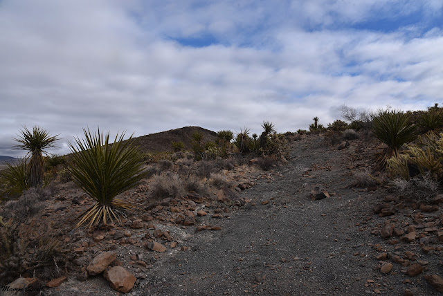 |
| Trail |
The local vegetation had a reception committee for us - yucca and cholla, backed with more creosote bushes. There were no Joshua Trees at all along that trail. The mild sun that was out when we started the hike was disappearing behind a layer of clouds.
 |
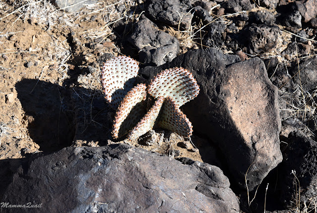
| Silver Cholla, Cylindropuntia echinocarpa, and Banana Yucca, Yucca baccata |
The region recent precipitation, there were numerous indications of that, including this odd looking mushroom that sprouted a few yards away from the trail. I went over to take a closer look, then had to chase my family up the trail.
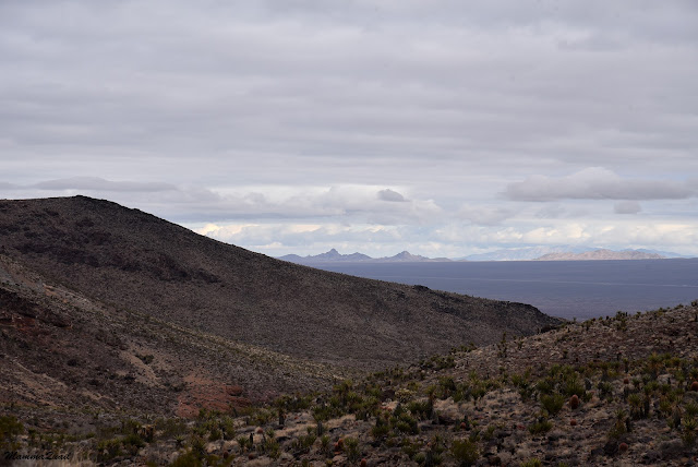
It was a short distance to the top of that hill. When we reached the top I gaped at the view of the eastern slope we were about to descend. The trail we were on was following the contours of a desert wash that seemed to extend to the horizon. It was flanked by rugged ridges dotted with cacti and other desert shrubs growing between rocks of gray or reddish color. The gray sky added to the sense of desolation of this place. We were all alone there, and I loved it.
My family didn't stop to appreciate the view. When I came over the ridge they were already far ahead down the slope. They didn't forget me however. Before long I heard the chikas calling me with excitement - they had found a flowering plant! It was a buckwheat and I saw several of these shrubs in bloom.
 |
| California Buckwheat, Eriogonum fasciculatum |
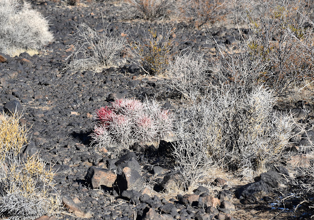
The California barrel cactus was very prevalent along the trail, but this one, a clump of five in a perfect pentagon, really made me smile.
 |
| California Barrel Cactus, Ferocactus cylindraceus |
Somewhere along this trail Pappa Quail saw another little bird - a kinglet. There weren't many birds to be seen in the area at all, or any other wildlife. Everything around was very still.
 |
| Kinglet |
The trail used to be a wagon road later used by motor vehicles. Now it is in such disrepair that I cannot imagine any type of vehicle using it. Maybe dirt motorbikes. Maybe. I'm not sure they're allowed there though. The 'road' was pretty hard for me too - because of a recent injury I had trouble keeping steady and balanced on the loose rocks that consisted the trail. Having to be extra careful slowed me down.
Not that I minded being slow. I got to see all the lovely flowers along the path. I was actually surprised to see a significant bloom there, so early in season. And it was just the beginning, I guess.
The bloom season in the Mojave can be offset with the other regions of California - monsoon rains set the stage for that.
Keeping that in mind, all bloom that I saw there were perennial plants. The annuals were just sprouting at the time, in response to the early winter rains.
 |
| Thick Leaved Ground Cherry, Physalis crassifolia |
Coming around the curve the view eastward opened up. The huge desert flat between the Mojave Preserve and the peaks that are at the Colorado River north of Needles. I could see in my mind's eye the wagon caravans plowing their way across that flat, aiming for the oasis where they could once again fill up on water.
 |
| View east from the Old Government Road |
The trail descends to meet the creek and at the bottom the road is completely washed off. We took a short break at the bottom, then continued downstream on the dry wash bed.
The top layer of gravel was dry but with each step we exposed the moist layer below. It's this retained moisture that supports the wash bed plants and allows them better growth conditions and a longer bloom season.
I sometimes wonder what happens to these wash bed plants during a flash flood. I guess they must have really long roots that keep them anchored down. I was glad to see the phacelia blooming bravely right in the path of where it recently flowed.
We continued down the wash. There was no marked trail and I couldn't see any footprints of other people. No one seemed to have walked this path since the last flow.
Earlier that week I've seen some creosote blooming with one or two flowers per bush. This was the first one I saw with n open flower since we returned to California. A single flower for that entire bush.
 |
| Creosote Bush, Larrea tridentata |
The hills that enclosed the wash receded away and the view opened up. All of a sudden we were walking once again on an established trail. Near the trail were rocks with petroglyphs. There were some that looked genuinely old and others that were obviously modern. The hiking book we looked at mentioned petroglyph rocks near the trail spur that leads to Fort Piute. That must have been it because we didn't see any other rock markings. We also didn't see the fort from where we were.
The creek had carved its path deep in a layer of red rock, which looked like a type of sandstone to me but I don't actually know. I do know that this was very pretty-looking. One of he best things I love about hiking in the dessert is seeing the bare land in all of its beauty.
Crossing that creek turned to be somewhat of a challenge, and the first real indication that the trail wasn't being maintained at all. We could barely see where the trail was continuing on the other side. We found a place to cross. The hiing book stated that this was a creek that run year-round, fed by the Piute Springs. Indeed, there was some water in the creek and I wondered if that's going to be an issue when going up the Piute Gorge after checking out the fort.
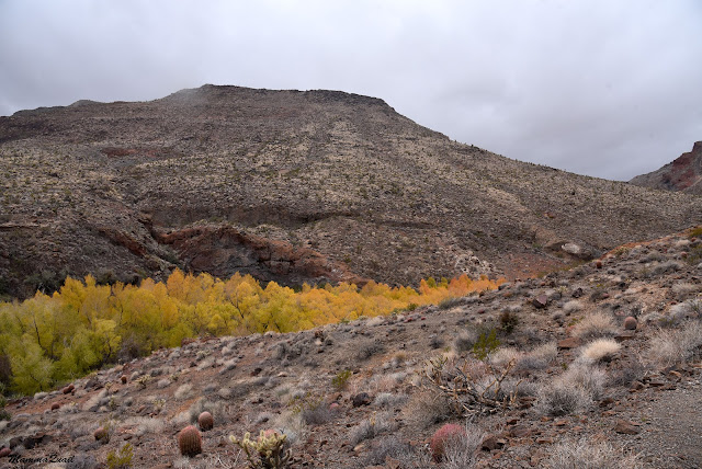
The oasis downstream of where we crossed the creek was very conspicuous. The poplars growing tall over the lip of the creek were having late autumn and the fall colors were absolutely stunning. I couldn't stop photographing them. They even head this blogpost.
This part of the trail is an in-and -out spur that goes above the creek itself. The strip of poplars stretched a good distance eastward, apparently all the way to the creek's opening. It was an impressive sight to see.
 |
| Piute Creek |
I took countless photos of this gorgeous oasis, but the composition below was Pappa Quail's idea - to have the red barrel cactus against the yellow and gray poplars. He sure has a good eye.
 |
| Piute Creek |
This day was the only day of our vacation week that had some rain in the forecast. This forecast actualized as we made our way along the creek towards Piute Fort. It was a very light rain, but it blurred my glasses and I needed to cover my cameras to protect it. Still, I uncovered it all to frequently to take photos of wildflowers.
It was an odd season to see wildflowers. There wasn't much bloom but that made those plants that did bloom truly stand out.
 |
| Brittlebush, Encelia farinosa |
Fort Piute was constructed in 1859 as a safe stop for the emigrants crossing the dessert, in the area that was Southern Paiute Nation territory. Very little is left from the fort today. Some reconstruction was done to erect the layout of the buildings for visitors to see and to place information posts around it.
The rain had intensified when we arrived at Piute Fort. We needed a break and wanted to eat but the only shelter we saw was the three-sided information kiosk east of the fort's ruins. We huddled there under the tiny kiosk, covered our cameras with my poncho, and had a quiet lunch break, gazing at the horizon. According to the map there is a dirt road that crosses the eastern flat up to about 2 miles from Fort Piute. I guess this is a possible access point for visitors who wish to access the fort from the east, like the Gold Rush emigrants did.
We used our lunch break also to review the book's description of the trail. I was concerned about getting our shoes wet going into the gorge from the creek but Pappa Quail read the trail's description and said that we needed to go up above the gorged past Piute springs and drop into the main canyon through a smaller side gorge. I checked my map and it agreed with the books description.
it was drizzling still when we got up to go, but we needed to start heading back. We didn't want to have to drive the dirt roads after nightfall.
I kept my camera hidden under my poncho while we walked back on the Fort Piute trail spur. Right above where we had previously crossed the creek we picked up the trail going above Piute Gorge. The yellow and orange tips of the Piute Springs poplars extended above the lip of the canyon, marking the place where the water came above ground.
It was at that point where we started the most problematic lag of our hike. The first sign of trouble was the increasing difficulty to find the trail. We started up and over the gorge on a visible path, although narrow and clearly underused and unmaintained. It didn't take too long for the path to become obscure. At that point I moved ahead to the lead position. Over the years I have gained some good experience in the skill of path-finding. It was my task now to find our way down to Piute Gorge.
The upside was that the drizzle had stopped.
 |
Piute Gorge, view from above
|
The path-finding job turned more and more difficult with each step. We would start on a clear trail segment only for it to vanish all of a sudden. Moreover, previous hikers on this path have done some erratic path-finding of their on and traces of where people have walked before and possibly backtracked were numerous and went in parallels along the hillside. There was a nice stretch of clear trail that ended abruptly at the edge of a collapsed cliff. I could see that trail continuing on the other side but we needed to climb the rocks above the cliff edge to get there. Ut didn't help that the young chika is sensitive to heights and needed close supervision during this traverse. There were a few places where I voiced the option of backtracking and returning by the same Old Government Road that we hiked down on. Going back however, seemed to be even more difficult, because it meant going down a steep and unstable slope. Neither of us was thrilled to do that, least of all my young chika.
 |
Heliotrope Phacelia, Phacelia crenulata
|
Our progress was painfully slow and precarious. At times I would go ahead on my own to scout and I would then direct my family where to go from. Eventually we found the way down to the side gorge that would take us down to Piute Gorge. The top part of that side gorge seemed tame enough, and we stopped there for a well deserved break.
While we were still on top of the hill I thought I saw a dry waterfall down that side gorge we were aiming for. We were a short distance from the main gorge and considering how high above it we were still, it was reasonable that there would be a waterfall, likely few of them, on the way down. The big question was, would we be able to descend down those rock steps. The book's author was positive about it but that was 18 years before, and the description had already turned to be invalid regarding the cliff path that we had just traversed.
I left Pappa Quail and the chikas to rest a bit longer and moved gingerly down the side gorge to take a look ahead. Around the first curve I had a view of the main Piute Gorge downstream of where the side gorge connected, and the colorful poplars that marked Piute Springs.
 |
Piute Springs, viewed from upstream and above
|
The side gorge proved passable, although very challenging. There were several waterfalls, some of which had rocky ledges that enabled us to descend them directly. a couple of them, including the one that was visible from above, were too high and steep to descend, forcing us to find a way around them on the hillside.
Most of the time I was the one leading the way. On a couple of these waterfalls I sent the elder chika ahead of me. She is agile and limber and would go down easily like a mountain goat. Pappa Quail and I would then pass her the cameras and the backpacks, and descend carefully with the young chika between us, guarding and guiding her down. On one occasion Pappa Qauil went down first then had the young chika lower herself to his shoulders, serving as a living step ladder for her.
 |
The last drop
|
I was the first one down at the main Piute Gorge, and I let out a whoop of relief and joy. The rest of the family joined me and we sat down for another well deserved break. The tension and stress was finally gone and even the young chika, who was on the verge of tears most of the way down was now in high spirits again.
It was also at that point that the drizzle resumed. It was time to move on again.
 |
Piute Gorge
|
I took one last look up the side gorge we had just came down on, then hoisted my pack and started upstream Piute Gorge.
 |
| Banana Yucca, Yucca baccata |
Pappa Quail was worried about our pace. Getting from the creek crossing over the hillside and down the side gorge, a segment of less than a mile in length, had taken us nearly two hours to traverse. No we were in risk of getting into darkness.
 |
Piute Gorge
|
I was more optimistic. At this point we had less than three miles left to complete the loop, and most of it would be outside the gorge, on e standerd dirt road. The book's description of the gorge did not mention any major obstacles. But then again, that description was 18 years old. Either way, we had nowhere to go but up the gorge, and so we did.
 |
Piute Gorge
|
Piute Gorge is gorgeous. Segments of narrow canyon with sheer walls interspaced with more open areas with large boulders strewn about. It was obvious that there had been a flow of water there fairly recently. In some places there were also small puddles left in rock depressions. Occasionally we came upon patches of sleek, sliperry mud, most of which we were able to bypass or hop across. Once I didn't pay attendion and stepped in one, covering my boot with red, pasty mud.
 |
Piute Gorge
|
The colors of the rocks were stunning. I was sorry that it wasn't a sunnier day because the colors would have come out better in brighter illumination. The contrast between the different tyoes of rock was very sharp and impressive.
 |
Piute Gorge
|
As the book promised, ascending Piute Gorge didn't pose any serious challenge. In some places we had to go up some waterfalls, all easily negociable (especially compared with those we'd encountered in the side gorge). Some times we had to find our way around huge boulders that blocked the bottom of the gorge. The drizzle had ceased.
 |
Piute Gorge
|
All and all, we were making great time, walking upstreamat a quick pace. I was a bit sad that we couldn't take our time there, it is a place that invites more in depth exploration. Perhaps another time.
 |
Piute Gorge
|
It was down at the gorge where I first spotted fresh footprints of another hiker. A single person, I'm assuming a man but the size of the show print and the length of the gait. That there would be another human being in a location so remote was not completely unreasonable. What surprised me about it was that the footprints showed that that person was walking downstream (I have not seen returning footprints), yet we had not encountered him. Whomever that person was, he didn't go up the side gorge and the hillside we were on. I thought it possible that he went down all the way to Piute Springs and perhaps found a way past the thicket there and out of the gorge through the water holes I had seen at the gorge's opening.
 |
Piute Gorge
|
We didn't make any stops on our way up the gorge. I paused briefly only to look at an blooming paintbrush plant, the only one I've seen blooming inside the canyon.
 |
Paintbrush, Castilleja sp.
|
When the gorge finally opened up I found myself inside a huge amphitheater of layered slopes of red earth, beautifully carved by water runoff. The dirt road that we needed to get back on was somewhere up there, on our left. I saw a rusty iron pole stuck in the ground and when I got there I foound a narrow trail leading uphill. I waited for the rest of my family to catch up and started ascending that trail.
Pappa Quail voiced some doubts about that trail. It too was unkempt and in some places it was so eroded that it felt like walking in a narrow creekbed. But ot appeared to be the only reasonable way up in the correct direction, so up we went.
 |
Anthills along the trail
|
I was the first to reach the top, where I found the small parking area of the Piute Gorge trailhead, and a gorgeous view of the Piute watershed below. The clouds broke a bit and the afternoon sun illuminated the red amphitheater, beautifying it even more.
Dark, heavy clouds still hanged over the east. The westering sun rays painted a faint rainbow on that gray cloud canvas.
 |
Rainbow above Piute Gorge
|
The Piute Gorge trailhead is adjacent to the dirtroad we needed to get back to our car. That park of the hike was simply going south straightforward on that flat and easy path. Having been alone all they long I was quite shocked to encounter a small convoy of SUVs dashing through the sand, raising dust.
I was glad when those vehhicles passed and the desert quiet returned. The clouds closed in on us once more, darkening the sky much earlier than nightfall would have. These clouds however, gave us yet another glorious sight when the sunrays broke through a cloud hole, streaming all the way down to the earth.
 |
Sun Display
|
We were quick getting back to the car. Just before reaching it however, I took a moment to appreciate the beauty of a small tree burdained with numerous mistletoe balls.
There was still daylight when wereached the car and we even managed to get to the main dirtroad before darkness engulfed the desert. The rest of the way back we drove in complete darkness.
That hike was definitely the pinnacle of our winterbreak trip. It was absolutely gorgeous, and very rewarding on many levels. On the other hand, that hillside part of it, that short, less than a mile connector of the Fort Piute trail with the Piute Gorge, was so dangerous and stressful, that I cannot recomend it to anyone that's not adept in negociating ths kind of terrain. It certainly isn't suitable for families with children or for people who have heights anxiety. I do recommend parking at the Piute Gorge trailhead and going down and up the main gorge as an in-and-out hike though. It's totally wrorth it. Going to Fort Piute can be another in-and out hike, and can apparently be done from the east as well. The loop however, I do not recommend. Not until a safer trail is made there.
On the following day we dropped by the Hole-In-The-Wall visitor center. The attendant there had no idea that there was any problem with the Fort Piute - Piute Gorge loop trail. Apparently, even if we did ask for information before our hike, it wouldn't have been useful.