I set my mind to wake up at 5:00 am and my alarm to go off at 5:30 am. It was 5:10 when I woke up and I got to see the beautiful sunrise. It was a cold morning, but not as cold as I feared, and the wind that blew last evening had died down.
White Mountain Peak is about 7 miles from the trailhead, so this hike can be done as a day hike. It was great not having to haul my bug backpack. My day pack had some food for the hike and plenty of drinking water. I also took my backpacking stove in case I needed to melt some snow, and just for the heck of it I took my emergency space blanket and the microspikes that I got from a nice Swiss backpacker that I met on the John Muir Trail earlier that week.
 |
| My hike as captured by my GPS |
One of the other guys that drove in last night was also getting ready to hike. I got the itch to get on the trail before him, but after a few steps into the trail I had to return to the car and peel of a layer of clothing. I resumed hiking with my base layers still under my hiking
clothes and I was still wearing my puffy jacket and my warm hat.
 |
| White Mountain Peak Trailhead |
The first bird I saw that morning was also cold. It was a sage thrasher and it was all puffy, increasing the insulation by fluffing out its feathers and taking the shape of a little ball.
 |
| Sage Thrasher |
A few steps past the sage thrasher I stopped again - off the trail I saw the jackrabbit, probably the same one I saw yesterday where I had pitched my tent. The other guy caught up with me, so I pointed out the hare to him. He asked me if I saw the deer when I drove up here. I told him I didn't, feeling a tinge of envy. He exchanged greetings and well-wishes for the upcoming hike and commenced walking up the trail. Within a couple of minutes he disappeared behind the curve.
 |
| White-tailed Jackrabbit |
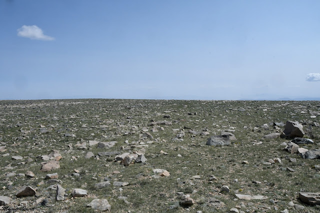
I started walking at altitude of 11,800 ft and I consciously kept a slow pace, keeping my steps in rhythm with my breathing. Occasionally I'd stop to take photos or to look around and absorb the scenery. I was higher than the tree line - there wasn't a single woody plant within sight. The skyline was made of only peaks and rocks. It looked outlandish.
The scenery was not static, though. There was a lot of movement going on. I quickly came to realize that I was walking in marmot country. These mountain rodents were all over the place, and their burrows were under every rock of any decent size. There marmots were also not shy - many of them cooperated well with the camera.
 |
| Yellow-bellied Marmot |
After a couple of curves I run into the first snow patch. It has already melted back, leaving most of the trail exposed. It seemed like it hasn't started melting yet today - the soil near the snow was dry. There were other patches of snow here and there, but not on the trail itself.
 |
| White Mountain Peak Trail |
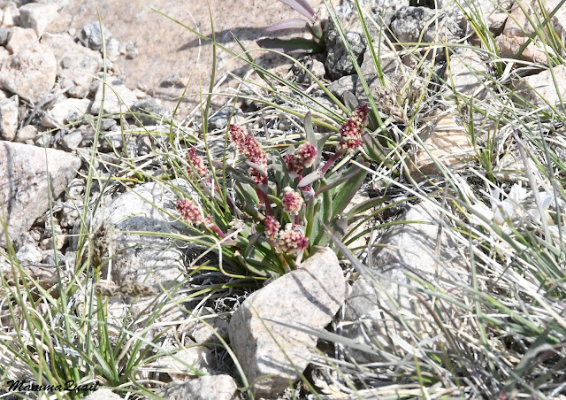
There were also wildflowers blooming there. Many, many wildflowers. They were all very small plants. Alpine, hardy, evolved to not only survive but thrive in the harsh conditions of the high mountains. The short growth season, the strong winds, the high radiation, and extreme temperatures, and also the healthy population of herbivores that feed on them. Many of them were growing in nooks between and at the foot of rocks, sheltering there from the winds and from being dug up by the rodents.
 |
| Dwarf Phlox, Phlox condensata |
I surprised another jackrabbit near the trail. He stopped silflay and stared at me until I finished taking photos and moved on. These hares are very well camouflaged - they look exactly like the rocks and it's their movement that gives them out. None of the jackrabbits I saw on that hike seemed too worried about me however. I guess they knew I was not risk to them.
 |
| White-tailed Jackrabbit |
One of the most common wildflower I saw on this trail was the few-seeded draba. Drabas are high mountain plants. They bloom almost as soon as the snow melts, taking speedy advantage of the precious sunlight in the fleetingly short summer. All the drabas I saw looked very healthy, and they were all at peak bloom, none of them straggling or gone ahead to seeds.
 |
| Few-seeded Draba, Draba oligosperma |
The trail curved again and a the low peaks appeared before me. These were the peaks of Mount Bancroft. Of course they only appeared low - Mount Bancroft is well over 13,000 ft. On the right of the mountain I got the first glimpse of the Bancroft Research Station. The trail I knew, would take me right through this station. I wondered what do people research there and whether I'd see anyone there. Meanwhile, as I approached the station, I saw familiar wildflowers - the high mountain hulsea. This hulsea species I've seen before in the Sierra Nevada
near the summit of the Big Sam mountain.
 |
| High Mountain Hulsea, Hulsea algida |
The trail just before the research station was almost flat, and little birds flew from rock to rock. I recognized them immediately - these were rosy finches. So far I am the only one of my family who had seen rosy finches - they like living in high altitude, and every time I've seen them before it was on a high sierra backpacking trip, including the one preceding this White Mountain Peak hike. On previous trips though, I've seen the rosy finches here and there, but now they seemed to be everywhere. Yet, they weren't very cooperative and wouldn't stand still for a photograph.
 |
| Gray-crowned Rosy Finch |
I passed along the Bancroft Research Station. It looked completely deserted and all the structures looked old and run down. I wondered if it was even being used at all these days when I noticed a small cabin that was apparently the lodging quarters. That cabin looked like it was set up and organized for a recent stay, so I supposed the research station was still functional, only not at the time of my hike. I passed a long structure that was labeled, "Nello Pace Laboratory". Later I checked who Nello Pace was - apparently he was a physiologist from UC Berkeley that founded and run this laboratory for 27 years before he passed away, and now the laboratory is named after him.
 |
| Bancroft Research Station |
I passed the research station and sat down on a rock to eat a snack. It is important to eat frequently sugar-rich snacks when active in high altitude, and I didn't need a better reason than that to eat some dried fruit and nuts. The trail so far wasn't flat, but the uphill slope was very mild. The first 500
ft I ascended over a length of nearly two miles. Despite the thin air,
the walk was easy enough. I was very pleased with my pace - I had covered nearly two miles in less than an hour. I was having it easy so far, but from this point I would be going up a steeper slope.
I looked around as I ate. A couple of marmots started at me for a minute, then scurried away. There were no colorful wildflowers right where I was sitting, but the grasses that bloomed there were also pretty looking.
 |
| Festuca sp. |
After my snack break the hike became a bit more intense - the trail, for one thing, was steeper. I ascended about 400 ft more over a much shorter distance. When I made it to the crest however, the White Mountain Peak was ahead of me, in its full glory. I also realized that all of the height I just gained I was about to lose now - the trail was going downhill into the saddle between Bancroft Mountain and the White Mountain Peak.
 |
| White Mountain Peak |
On that crest however, before descending into the saddle, I had a great view of the Sierra Nevada eastern peaks. I was standing at about the same altitude of much of that magnificent skyline.
 |
| Sierra Nevada |
I thought about the numerous Pacific Crest Trail/John Muir Trail hikers that were there, and that only two days ago I was on that very same trail, a bit more south of where I was now.
 |
| Sierra Nevada, view northwest |
I resumed the faster pace as I descended into the saddle, but I kept stopping to look at and photograph the plant-life and wildlife that was all around me.
 |
| Alpine Sheep Sorrel, Rumex paucifolius |
The yellow-bellied marmots were the most common wildlife that I saw around me. I also saw many golden-mantled ground squirrels too, although in distinctly different areas than where the marmots were. Nearly all of the squirrels vanished as soon as the noticed me noticing them. There was one however, that came near and stared at me until I finished taking photos and moved on.
 |
| Golden-mantled Ground Squirrel |
At the base of the saddle, I was back down almost to the altitude of the Bancroft Research Station. It was now time to regain all of the feet I had lost descending. There, a bit off the trail, was a National Forest sign stating that I was now in the White Mountain Wilderness.
Going up the next crest was once again slow. I found that it was easier for me to keep a steady pace if I run a song in my head and walked with the beat that was in my mind. It was a good way to keep my gate synchronized with my breathing. When I reached the crest of the second uphill section I have regained all the altitude lost and gained about 500 ft more. I also had another great viewpoint of the Sierra Nevada, and also of the north side of Owens Valley below, and it looked very dry and desert-like.
I turned my attention back to the White Mountain Peak. The trail was making a long curve before approaching the summit trail itself. dipping once again a couple hundred feet in altitude, and on a much steeper slope than before. I recalled that I haven't yet run into the other hiker that went out ahead of me, and I wondered how far up I'll be when he came down.
 |
| White Mountain Peak |
I knew there should be a cabin at the summit and when I zoomed in on the mountain top, I could see that the cabin was indeed there.
 |
| White Mountain Peak |
I started descending to the base of the White Mountain Peak summit stretch. To my right there was this open plateau empty of trees and bushes, not even low shrubs. There were short grasses and tiny wildflowers, their colors invisible in a broad view. The field was strewn with rocks. This was marmot heaven for sure.
 |
| Marmot Heaven |
There were quite a few insects on this mountain ridge. Not butterflies though, but lots of interesting flies, little beetles and possibly solitary bees. There were also lots of grasshoppers. They liked hanging on the trail and they jumped or flew to the side from beneath my steps.
 |
| Grasshopper |
I kept seeing more wildflowers growing near or even in the trail itself. I kept taking photos, even of wildflowers I've seen already.
 |
| White Mountains Mousetails, Ivesia lycopodioides var scandularis |
Then there were also new species that I was seeing for the first time now, four miles into the trail. They were so tiny I had a hard time taking any recognizable photo.
 |
| Lemmon's Rockcress, Boechera lemmonii |
The marmots kept being a constant presence along the trail. While most of the scurried off when I passed, some would stay and look at me. Some marmots would also emit their squeaky warning calls as if I was some great big danger to them,
 |
| Yellow-bellied Marmot |
At the base of the summit pitch I sat for another snack and hydration break. I was planning to have my lunch at the summit but I didn't want to hike up there on empty stomach. When I got up and started my final ascent my pace was much slower. The songs in my head changed from allegro to andante, and then to largo.
 |
| White Mountain Peak Trail |
The plant coverage of the rocky ground thinned considerably. The little green cushions were now fewer and further between. Most of them were grasses and the few-seeded draba, but I also encountered a patch of the high mountain hulsea, which probably were the tallest plants present. The hulsea growing at this part of the trail (around 13,200 ft) were behind those I've seen near the Bancroft Station - they were just starting to bud out now. Only one inflorescence was open.
 |
| High Mountains Hulsea, Hulsea algida |
Throughout the hike I kept seeing large, black spiders but they all scurried away all too quickly. Finally there was one that paused long enough for me to take its photograph.
 |
| Wolf Spider |
I was now well above the highest altitude that I acclimated to on the preceding backpacking trip in the High Sierra. My progress was slow and I had to pause and catch my breath frequently now. On one of these pauses I looked up to the summit - I had about 1000 ft to hike up still, over about 1.5 miles.
 |
| White Mountain Peak |
On my breathing pauses I took the opportunity to look around and take some scenery photos. Unlike the Sierra Nevada, the White Mountains are steep on both the eastern and western sides. As far as I know, there are no year-round springs in this mountain range and the water here come entirely from precipitation.
 |
| View Northeast |
The canyons and gulches coming down the northeastern slopes of White Mountain Peak were mostly arid, but one of them was, surprisingly, green. This was the north fork of the Perry Aiken Creek.
I maximized my camera zoom to get a better look. The gulch's slopes were forested - likely with bristlecone pines in the higher elevations, possibly changing to junipers and pinyons at the lower elevations. Naturally, the north-facing slope was more thickly forested than the south-facing slope. The bottom of the gulch looked bright green with what might be riparian vegetation. There was water there for sure. I didn't know though, if the creek continue flowing after the snow all melted but some water holes might persist - I've seen Lower Perry Aiken Creek listed as a fishing spot in western Nevada.
 |
| Perry Aiken Creek, north fork |
The White Mountain Peak rose sharply from its base but the trail remained mild-sloped through a series of nice, long switchbacks. At the turn of one of those switchbacks I finally run into the other hiker than was now on his way back. He stopped (I appreciated the breather break) and we chatted a bit. He told me he had is own lunch up at the summit and took his time laying down in the sunshine. He also asked me if I saw the mountain goats on the way. "What mountain goats?" I asked. He told me he's seen a herd of about ten animals, right by the trail. Now I was truly envious. I didn't correct him because I haven't seen the animals in question but I thought these were likely bighorn sheep, rather than mountain goats. I told him than maybe I'll get lucky on my way down. We bade each other farewell and both of us resumed our hike. A couple of
minutes later I looked down and he was a minuscule dot far below.
 |
| White Mountain Peak Trail |
My disappointment for not having seen any mountain goats or bighorn sheep changed into a hallelujah moment when I saw sky pilot plants blooming long the trail. Sky pilot is a very high altitude plant. I've seen it up Mount Whitney three years ago, and also on Baxter Pass and Glen Pass during my altitude acclimation trip earlier that week. As it turned out, this one was an even more special finding because it was a different, species - the White Mountains Sky Pilot. Endemic and rare.
 |
| White Mountains Sky Pilot, Polemonium chartaceum |
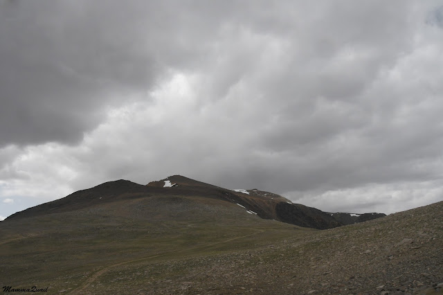
Clouds were starting to gather over the White Mountain Peak. My puffy jacket, which came off earlier on the hike, came back on and remained there to the end of the hike. The other hiker also warned me that part of the trail higher up was still covered in snow. He also told me that there were makeshift trails bypassing the snow field.
 |
| Snow on the White Mountain Peak Trail |
When I reached the place he talked about I saw that those bypassing trails
involve scrambling up in the scree. I've had to do a lot of that going
up both Baxter Pass and Glen Pass on my preceding trip and I was fed up
with it, but I still preferred scrambling up the scree than to don the
microspikes and go across the snow.
 |
| Scramble makeshift trail up the scree |
The bypass reconnected with the main trail again about a hundred feet higher. By then I had only a couple hundred feet more to ascend, and I took it slowly - the air was very thin and I was starting to feel lightheaded.
 |
| White Mountain Peak Trail |
On my last leg up I took more frequent breathing pauses, and to appreciate the view. Faraway below me to the southwest I saw the town of Big Pine.
 |
| View Southwest |
I don't remember when I noticed that there were no more plants growing along the trail. The only living thing I could see were the lichen on the rocks.
I reached the summit and fount it deserted. I knew that the other hiker was already downhill but there was that third guy sleeping at the trailhead too and I thought he might have had an even earlier start than me. There was no one at the summit though.
 |
| Summit Cabin |
The peak sign was laying down in a circle of rocks near the cabin. There was no one there to ask of to photograph me holding it so I settled for photographing the sign itself.
By the time I reached the summit the clouds had gathered above. I sat on the concrete ledge by the cabin's entrance, took my stove out and started boiling water for tea. I stayed at the summit for nearly an hour, eating my lunch and enjoying hot tea and beautiful view.
 |
| View Northwest |
The cabin had two doors and one of them had an old and rusty "Do not enter, experiment in progress" sign. I didn't even try the doors, not caring what might be inside. There was a metal box near the other door and inside were notebooks with writings, lost hats and possibly other things. I didn't delve into the box either. When I finished my lunch I boiled another batch of tea which I poured into my thermal mug for the way back. I then packed up all of my things and waked to the other side of the cabin to see the view from there of the north section of the White Mountains.
 |
| View North |
The White Mountain Peak is still within California but the northeastern part of the White Mountain Range is already in Nevada. Looking east I could see the desert land made arable through irrigation. Do the irrigation water come from the White Mountains?
 |
| View East |
It was getting windy and cold. I donned my mittens too and started down the trail. It was a bit of a challenge to find the scramble makeshift path downhill and when I did, I had to take special care to not slip on the scree. When I made it down back to the official trail I also noticed, a few steps later, that I was seeing plants again.
 |
| Draba? |
The way downhill on the actual trail was quick. Not worrying about slipping, I allowed myself to go fast, almost at a trot. There was another reason for my speed - I could see rain in the horizon and I even heard thunder a couple of times. It was definitely time to get off the high mountain, the last place I'd want to get caught at during a thunderstorm.
 |
| View South |
Galloping down didn't mean not pausing for wildflowers, so I did take some photos on my way to the base of the peak.
 |
| Mount Hood Pussypaws, Calyptridium umbellatum |
When I had a nice broad view of the next part of the trail I stopped and looked carefully at where the trail snaked up the next ridge. Yes, I was searching for them mountain goats that the other hiker had seen.
It took me a couple more switchbacks downhill before I saw the movement on the north-most curve of the trail below - there they were! I was hoping that they'll be there still when I reached that part of the trail.
 |
| Desert Bighorn Sheep |
Thankfully the animals didn't seem phased at all by me being there. They merely moved off a bit. They were, as I have guessed, bighorn sheep (a desert subspecies) rather than mountain goats. I've only seen mountain goats once before, in the North Cascade National Park in Washington, and I didn't think there were any in California. I was very happy to see the bighorn sheep though. They are not easy to find.
 |
| Desert Bighorn Sheep |
It was a small herd of females and lambs. I saw no mature male among them. I wondered if they spend all of their time up ion this altitude or whether they migrate downhill at nights.
 |
| Desert Bighorn Sheep |
Moving on I found that going uphill again, even for a little bit, was very tiring. I went at a slow pace again, even though I was at a lower altitude now. I had a hard time feeling energized to I took a short snack break, hoping that some dried fruit and nuts and a bit of rest for my legs would do the trick. They sure did. Looking back at the White Mountain Peak I saw it crowned with dark, heavy clouds. It didn't look like it was raining though.
 |
| View back at the Peak |
I made it up to the middle ridge where I could resume a good pace again. There I saw more of the rosy finches and I stopped. Finally, after a bunch of attempts at these hyperactive birds, I managed to get a good enough photo of one of them. I photo I could brag with to my family birders who had never seen this species before.
 |
| Gray-crowned Rosy Finch |
From the ridge I had an excellent view of yet another part of the Sierra Nevada Mountain Range. In the afternoon illumination I could make out the details of these gorgeous mountains above the city of Bishop.
 |
| View West |
The hardest part of every mountain I summited was the way down, and this time was no different. The trail was easy enough, but the altitude was still pretty high, the trail seemed endless, and I was getting fatigued and cold. It was on that middle ridge that I started having thoughts of maybe not camp my last night in the area but book myself into a hotel room instead.
 |
| White Mountain Peak Trail | |
Between those renegade thoughts I was still enjoying the great views and the many wildflowers that decorated the trail.
 |
| Morefield Cinquefoil, Potentilla morefieldii |
I was still seeing new (to me) wildflower species too, even though I was going back the same trail I came out on. Some of these plants were so tiny it's no wonder that I missed them on my way to the peak.
 |
| Pygmy-flower Rock Jasmine, Androsace septentrionalis |
There were other sights that apparently I missed on the way out such as this campsite near the trail. I guess someone must have sheltered there in the past.
I found another species of draba, and one that I was unfamiliar with. It is possible that I've seen it in the past when it was done blooming. Here I was early enough in the summer to catch all of these little beauty in their peak bloom.
 |
| California Draba, Draba californica |
One again the marmots were all around me, left and right. One of them run back and forth near me in a strange pattern, occasionally rising on her hind legs and staring at me expectantly. At first I though that she might be wanting food and then I realized that I was standing right over a burrow.
 |
| Yellow-bellied Marmot |
I stepped back a bit and the marmot took the hint and dived right into the burrow. Well, she had her burrow right at the trail.
 |
| Marmot Burrow |
I took one more snack break before going up the slope of Mount Bancroft and finished the tea I brewed at the White Mountain Peak summit. On the ridge I saw the upper post of the research station - from there the rest of the hike would be all downhill.
 |
| White Mountain Peak Trail |
Ar the last crest of the trail I turned around and bade farewell to the White Mountain Peak. It looked like the clouds were moving away from the peak, and its eastern slopes were illuminated by direct sunlight now.
 |
| White Mountain Peak |
Large mounds of rocks were common on the ridge and one of them seemed to shelter numerous marmots. I tried counting them but they kept moving around, in and out of the rocks so I gave up.
 |
| Rock Mound |
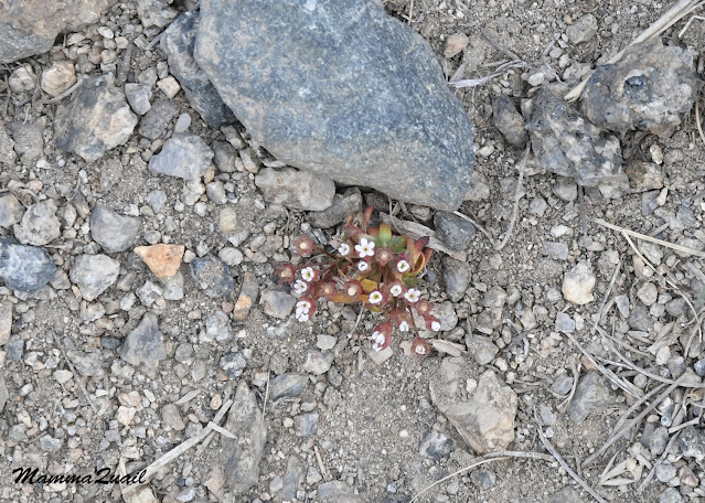
Paying closer attention to the ground I saw that not all the plants were at peak bloom as my first impression was. Some were a bit behind. I hoped they would complete their cycle before the snow came back.
I was elated. I was also exhausted. I felt very cold despite cranking the car heater up. When I eventually made it to the Grandview Campground where I had planned to spend the last night of my trip I drove past it without even slowing down. I continued driving all the way down the mountain to Big Pine where I checked myself into a local motel. I had earned a hot shower and a bed for that night.


Happy Birthday! you really had an amazing day there. I'm starting to really like the Hulsea genus. and you saw Androsace! we have Androsace maxima on Mount Hermon, it is a tiny flower despite the "maxima" in the name, and it looks very similar to your Androsace.
ReplyDeleteHow much time did it take you to go the whole trail?
Considering the harsh conditions and the very short summers up there, it is amazing how many wildflowers grow and thrive up the White Mountains! The Hulsea are beautiful. Remember we've seen the red one going up to the Whitney Portal? I don't remember seeing the Androsace before but then again, it's so small I might have just overlooked it. For me the special one was the White Mountains Sky Pilot :-) The entire hike took me about 11 hours. I walked pretty slow and took many breaks, including an hour long one at the summit. I loved it!
DeleteThis certainly was a challenging but rewarding hike.
ReplyDeleteIt was the perfect birthday present for myself :-)
Delete