Showing posts with label 2020 youth road trip. Show all posts

Sunday, August 25, 2024

A Grand View Epilogue of a Grand Road Trip: Hiking Harper's Corner Trail at Dinosaur National Monument

Lower Green River


Date: July 23, 2020 
Place: Dinosaur National Monument, Dinosaur, Colorado
Coordinates: 40.524930, -109.019617
Length: 2.3 miles
Level: easy


The visit at Dinosaur National Monument was at the trail of a long and capricious road trip I took with my daughters and two of their friends, all youth, in the summer of 2020 after the pandemic did away with our initial plans for that summer. Dinosaur NM was kind of an epilogue for this trip. It was beautiful and interesting enough to have our trip end on a high note although everyone in my group was already weary from traveling. I would have loved to go on exploring, but the kids were certainly reaching their limit. The night after our visit of the Exhibit Hall and the Fossil Trail hike they had their first (and only) scuffle on this challenging trip. They resolved their differences quickly, but it was clear that their resilience was wearing thin. I already told them that Dinosaur NM was our final destination. We'd have one last short hike there before turning west and heading home. 
Gnatcatcher at the Split Mountain Campground

Not in a hurry, we took our time breaking down and clearing out our campsite. My elder chika did a short stroll around the campground and stopping by the river, looking for birds. 
European Starling

I sent the other youth to join the elder chika on her birding stroll while I remained behind to finish washing the breakfast dishes and load the car with everything. After so many days I needed some alone time as well. 
Yellow Warbler

Dinosaur NM spans two states. To get to Harper's Corner where our final trail was, we had to exit the park and head east into Colorado. We drove through the town of Dinosaur (yes, that's its real name) then turned north to get to the trailhead. The elder chika found a bird at the trailhead too. 
Spotted Towhee, Juvenile

Harper's Corner trail is an in-and-out trail that follows a narrow knife-edge ridge, leading to a view point on the Green and Yampa Rivers. These rivers meet within the Dinosaur NM area. The jointed river continue south as the Green River until meeting the Colorado River in Canyonlands National Park in Southern Utah. 
Our hike as captured by my GPS

It was a hot day. We packed water and started up the trail. A few light clouds dotted the otherwise deep blue sky. 
Harper's Corner Trail

The ridge of Harper's Corner had a loose forest of small pines and junipers. These were beautiful trees, but they didn't cast much shade. It didn't take long for all of us to break sweat. 
Pine 

A few of the pine trees were dead, but standing still. Their twisted figures and exposed wood rings reminded me of the ancient bristlecone pines of the White Mountains in California. 
Dead Pine

We were high on the ridge and it was dry all around. The nearest river was thousands of feet bellow, in a deep canyon. Still, there were a few wildflowers blooming here and there. Small, and few, but in bloom. 
Rock Goldenrod, Petradoria pumila

Some of the wildflowers that I did see on the Harper's Corner Trail were minute, as befitting desert plants. 
Grounddaisy, Townsendia sp.

Fairly soon into the hike we started seeing grand views. Harper's Corner ridge protrudes into a canyon-land area carved by the Yampa ad Green rivers. Between the trees we started seeing glimpses of the huge valleys and plateaus below. 

I detected a parking area and a dirt road far below, on the south. I think it was the same dirt road we took yesterday to get to the Steamboat Beach on the Green River.

Between the bottom of the canyon and the height of the mountains on the south there was flat, light yellow strip that looked like sand. Below it was a gorgeous formation of  giant steps descending into the canyon,  The magnificent geology of the place was completely oblivious to the arbitrary border line that humans drew between the States of Colorado and Utah. The Colorado side of Dinosaur National Monument was no less impressive than the Utah side.  

The next gap in the trees revealed to us a direct view to Steamboat Beach. This beach is located on a tight curve of the Green River, a short distance downstream of its confluence with the Yampa River. 
Steamboat Beach

On the afternoon of the day before, after our Exhibit Hall visit and the fossils hike we drove down to Steamboat Beach where we dipped in a shallow area away from the main current of the river, and enjoyed a relaxed time there. The photo below I took while on the Steamboat Beach. This location is also a resting place for rafting groups that go down the rivers. If my path takes me to Dinosaur NM again I would like to go rafting there as well, it looked like great fun. 
Steamboat Beach, July 22, 2020

Further down the trail we got some incredible views eastward of the Yampa River canyon, and north of it a glimpse of the Green River canyon, and the place of their confluence point, although I couldn't see the actual flow until just upstream of the Steamboat Beach. 

On the northwest of the narrow ridge we were walking on, we had another incredible view - of the Green River past its confluence with the Yampa River. An enlarged image of this view heads this blogpost. 
Post-confluence Green River

The day was getting hotter and the youth requested a break. After sitting for some time three of them, two of which were my very own chikas, insisted on staying put, saying it was too hot and that they were too tired to go on. Seeing that it was an in-an-out trail and that they had a nice shaded spot to sit in, I left water with them and went on the hike with the forth youth who wanted to see the end of the trail and the views from there. 
Harper's Corner Trail

The trail dropped a bit on below the ridge line on the east side. Lovely little pines and junipers adorned the rusty-colored slope we were walking on. 
Harper's Corner Trail

I couldn't have enough of the magnificent views of the Yampa and upper Green rivers. I didn't count how many photos I took of this view but I know the choice for this blog post was really difficult. 
Meeting Rivers

As if to even things out, the trail then moved us to the west side of the ridge, treating us to even more awe-striking view of the lower Green River. 
Green River

I increased the zoom of my camera to maximum and focused on the water way far below. It was easy to see why this river was named Green River. I tried spotting rafters there but didn't see any. 
Green River

The chikas' friend and I arrived at the view point at the end of the trail. I don't know who Harper was, but his corner has some of the most grand views I ever seen. 

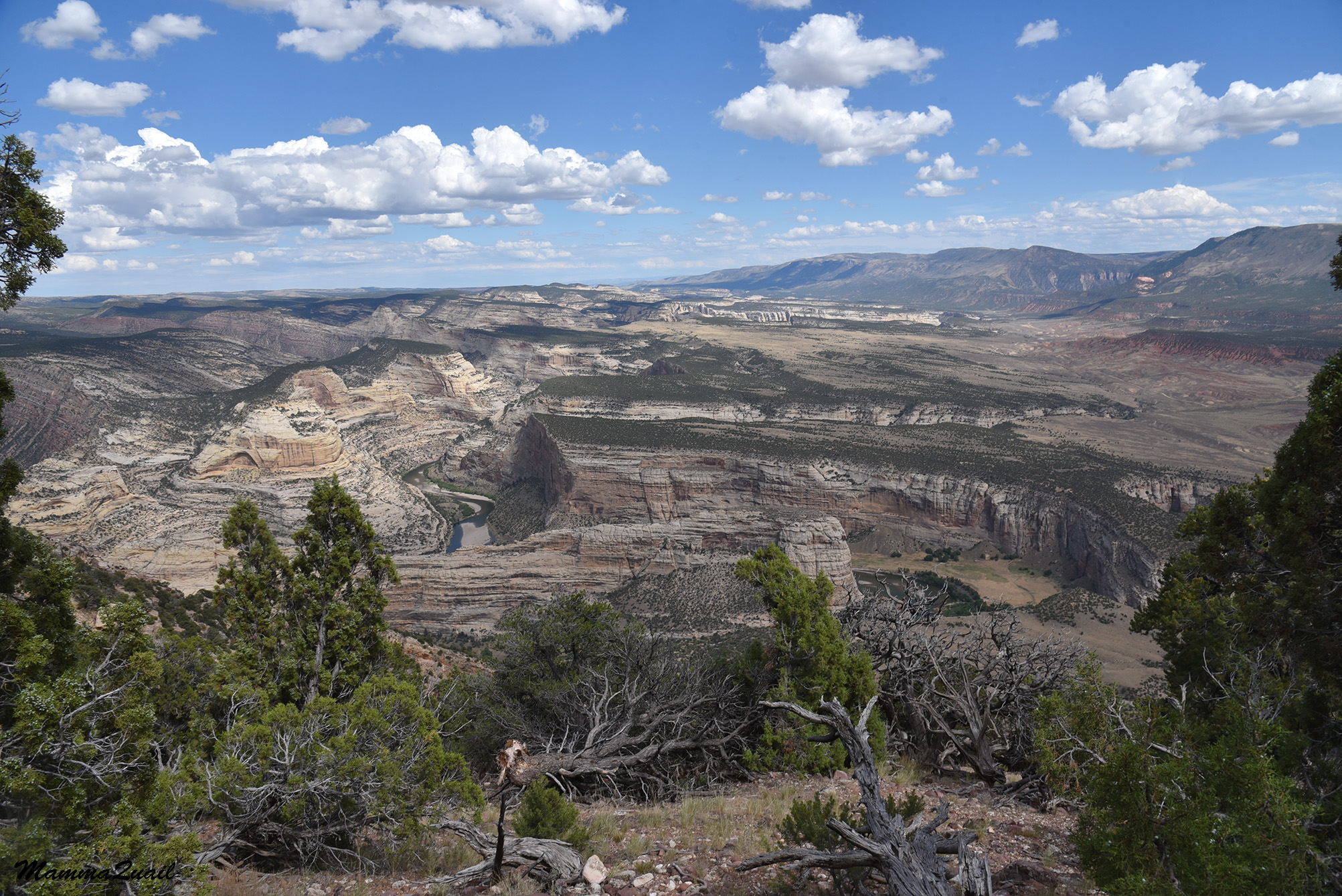
The lower Green River was just below us now, and it was incredible to see the change between the geology with the lighter colored rocks on the east side of the view point (in the photo below) and the darker, more forested west side (the next photo below). 
Lower Green River

I assume part of the difference can be attributed to the direction of the slopes - the west-facing slope is usually wetter. There must be some geological difference there too, though, but I'm no expert the local geology there. 
Lower Green River

We didn't stay long at the view point. It was hot and exposed there, and I thought of the other three youth waiting in the shade half way back. So me and the forth youth that joined me turned around and started back down the trail. 
Harper's Corner Trail

The walk back was quick. We didn't take any rest breaks now, just quick hydration pauses, and an occasional photo stop. 

We found my chikas and their friend waiting in the same spot where we left them. They didn't seem to miss us much but they did look happy that we were on our way back to the car. 
Harper's Corner Trail

Closer to the trailhead I slowed down a bit to take more photos of wildflowers that I've seen there on the way in. Some of them were not only small but also farther from the trail and not easily accessible. 
Scarlet Gilia, Ipomopsis aggregata

Harper's Corner wasn't a wildflowers hike. The trail was all bout the geology and the great views. Yet the few summer flowers there were noteworthy. 
False Goldenaster, Heterotheca sp.

By the time I finished my hike the youth were already waiting for me near the car. My elder chika used the time to find and photograph a Woodhouse scrub jay that was perched on top of a small tree, backdropped by what was the only clouded part of the sky. 
Woodhouse Scrub Jay

The clouds continued to gather as we drove down back to the town of Dinosaur and when we crossed back into Utah, a mild summer rain begun. I turned the car tin the way of Salt Lake City and we started our long drive back home to the Bay Area

The Harper's Corner hike was the last hike we did on this wild 2020 summer road trip. It took us three days more to return home, three days in which we had a few other adventures (like racing the car on the Bonneville salt flats and then having to take the car for a power wash), but had no more hikes. This is therefore, the last blogpost about this trip.  

I thank that the youth were so accepting of my wild ideas, their willingness to come with me on such a trip and go on these hikes too. I was grateful for their trust in me. I could only hope they enjoyed it as much as I did. Or at least, that they found it a superior alternative to staying at home during the height of the pandemic.


Friday, August 23, 2024

The Real Jurassic Park: Hiking the Fossil Trail at Dinosaur National Monument

Fossil Wall


Date: July 22, 2020
Place: Dinosaur National Monument, Vernal, Utah
Coordinates (of the Quarry Visitor Center): 40.438539, -109.307211
Length: 1.2 miles 
Level: easy (one way downhill)


Looking back at my 2020 summer road trip with my chikas and their friends to Yellowstone I can say that despite the challenges of such an impromptu trip with four minors, it was also a time with a great sense of freedom to go wherever and see whatever I had my mind on. Our main destination for this trip were the Yellowstone and the Gand Teton national parks and we explored them for about six days. There was a lot more to explore in these immense parks, but it was challenging to have to move our camp every day, and basic facilities, including showers, were closed due to the pandemic. In short, after seeing the highlights that each park had to offer, we moved on. Having a few days still on our travel plan, we exited Yellowstone on the northeast. We passed through the recreational town of Thermopolis where we enjoyed some hot springs time, then continued south to Fort Washakie, where we visited one of the presumed grave sites of Sacagawea, the legendary Shoshone guide of Lewis and Clark. 
After Fort Washakie we continued south to Dinosaur National Monument, on the border of Utah and Colorado. 
I've added Dinosaur National Monument to our itinerary on a whim. It is a very isolated place and I had a feeling that this was my opportunity to see it, since we were sort of, 'in the area'. It was a long drive still to get there from Fort Washakie, through mostly wilderness area which was both beautiful and desolate. We arrived Dinosaur NM in the afternoon, in time to get some impression of the west side of the park, and to set up camp at the Split Mountain Campground, where we were assured to have two nights of stay. This was the only place on our trip where we didn't have to move our camp first thing in the morning, and it was a great relief.
 
Green River, near the Capmground

On the morning of July 22, 2020 we drove to the eastern entrance of the park where the fossils exhibit hall and the fossils trail were. Naturally, the first thing I notices after I parked the ca was a wildflower in bloom. 

When we came in the park on the day before we had only little time to enjoy the geological beauty of the place. Now I could take in the colorful landscape. 

About 150 million years ago this place was open space with a large river running through it. The river had a tight curve in the spot we were now at. Animals that died in the river were swept away by the current, but the river bend trapped the largest of them all - the biggest dinosaurs. Over a 150 dinosaur skeletons were dug up here, of 15 different species, some found only here, all of which of large dinosaur species.

At some point excavation was discontinued despite many more fossils still buried in the earth there. A rock wall with exposed remains was enclosed in a building and turned into the exhibit hall. We took the tram up the half a mile asphalt road up to the exhibit hole, and joined other visitors who stood there, gaping at the fossilized pile of huge bones. 
Dinosaur Fossils

In my childhood I used to be obsessed with dinosaurs. I learned their names, collected cards, and read books and articles about them. Then I lost interested in the bygone, turning my passion to the contemporary nature. Now, as I was looking at the massive wall of fossils, I felt my old fascination with these giant reptiles welling up inside me. The youth in my group were quite inspired as well, and not only by the fossils but also by the paleontological research and the reconstructed skeletons that were on display inside the hall. 
Fossils wall

We stayed inside the Exhibit Hall for a long while, but eventually it was time to go. We decided to take the long way down - not to ride the tram again, but to hike down the mile or so trail through the wadi. 
Fossils Trail

150 million years ago this area was lush and productive enough to support herds of giant dinosaurs. In modern time Dinosaur National Monument is an arid, a high desert. Trees were few and far between, and those we saw away from the river were pretty much all drought-tolerant junipers.
Rocky Mountain Juniper, Juniperus scopulorum

The trail downhill follows the path of a short desert wash that drains the same plateau where the main excavation site was. We were told to look out for fossils along the way down, and so we did.

Even without the presence of fossils, this trail was a lovely piece of geology. The naked slopes, typical of a desert area, were very colorful, showing layers of different types of rocks with mineral composition.

Keeping on the lookout for fossils we started seeing them in the rock face. Irregularities in the rock were not hard to find, but interpreting what we were seeing wasn't easy. The formation in the photo below is interesting, but I'm not sure it is a fossil.
Fossil?

We were going down a trail through time. The wash cut through the rock layers, eroding them top to bottom, sending bits of newer sediments tumbling down passing much older sediments  on their way to rest at the newest, aluvial soil at the valley below.  

It was at the layer below the top, a contorted gray type of rock, that we found what was clearly fossilized bone. There was no mistaking the structure of the thing. Here be dinosaur remains, resting until excavated, or eroded to fine bits. 
Exposed bone fossil 

I explored the fossils area a bit longer while the youth darted downhill. It wasn't a long way down but that short distance hike offered some very interesting sights. 
Trail

It even offered some wildflowers, blooming in the height of summer, in an arid and hot desert. The high desert of Utah does get monsoon rains, some of them even soak through, but most summer precipitation there becomes fast runoff that feeds int flash floods. 
Mallow

We've experienced some of these summer rains on our trip, but today the clouds were light and it looked like no more rain for the time being. 
Trail

At the bottom of the wash the rocks were different again, of older, more colorful nature. A sign post at the wash opening said that the little yellow circles we saw in the rocks were actually fossilized fish scales, originated in an even older time when the area used to be under water, the bottom of a warm, shallow sea. 

I didn't get good photos of those little yellow circles. I had much better success photographing large, red rock walls. 

The rock crevices here were older, with more soil accumulated in them to support rich plant life. Some of these plants were in bloom. 
Rock Goldenrod, Petradoria pumila, growing on Mowry Shale rock, with yellow fossil fish scales.

From the wash opening we still had about a third of a mile walk back to the visitor center where we parked. There was more to see along this short stretch of trail too.

There was this little cave below the slope. We looked inside it but there wasn't anything in there. Perhaps animals find shelter in it during night time, or when it storms.

The valley spread flat before us. The flat looks cab be deceiving - the plateau was cut deeply with small, narrow canyons, making it hard to traverse. The trail was along the bottom of the hills and avoided crossing the cracks in the earth. 

One other thing to see along this trail was a relic of a much more recent history than dinosaurs - it was an area of petroglyphs that were etched there by the native people of the area that predated the modern day Ute nation.
Petroglyph

Some of the petroglyph were of obscure nature, but others were much more straight-forward and easier to understand.
Petroglyph

The youth in my company were on the lead throughout the hike. At some point a couple of the came back to me calling with excitement that they found fire ants. I followed them to an active anthill. There were ants there, all right, and they were red. If they were in fact fire ants, I have no idea.
Ants

I found a few more wildflowers near the tail. This summer there was a hard drought in the entire of the southwest, but there was still some desert bloom to see.
Hoary Tansyaster, Dieteria canescens

A little lizard rested vertically on one of the colorful rocks near the end of the trail. I snapped a few shots before it took off and hid in a crevice.
Plateau Side-blotched Lizard

From ear the trailhead we could see a lot of green fields - watered by the Green River. The lawn surrounding the buildings near the trailhead was green as well, drought or no drought. All around it however, the soil was dry. We spotted a cottontail rabbit in the dry area, near the edge of the lawn, no doubt checking out the meal plan.
Cottontail Rabbit

We completed the hike and went to a picnic area to make lunch. There was probably time for another hike but the youth were already warn out from the long trip and showed some dissent between them. Instead of hiking we drove down to Steamboat Beach, near where the Yampa and the Green Rivers meet. Then I took them near Split Mountain to climb rocks and have fun before heading back to the campground to continue a relaxed afternoon on the shore of the Green River.
Split Mountain