Showing posts with label Lake Chabot. Show all posts

Saturday, February 1, 2025

Chasing the Runaway Balls on the Goldenrod Cascade Loop Trail at Anthony Chabot Regional Park


The Cascade Waterfall


Date: January 10, 2025
Place: Anthony Chabot Regional Park, Oakland, California
Coordinates: 37.753850, -122.118217
Length: 4 miles
Level: mildly moderate
 
 
The January hike planned for the 4-H hiking group that I lead was planned for the Goldenrod/Cascade loop trail in Anthony Chabot Regional Park. It is a lovely trail that I hiked many times before, and I even wrote about way back when I just started this blog. At that time I hiked this loop as part of a longer hike starting and ending at the Lake Chabot Marina. It amounted to 9 miles altogether, and I did not intend to take the 4-H group of children on such a long trail.  The loop on its own is only 4 miles long - a convenient half a day's hike. Since it had been a few years since the last time I hiked this trail, I went on a prep hike prior to taking the group, and I invited my elder chika to come along.
Our hike as captured by my GPS

So on a bright, sunny Friday we parked at the Clyde Woolridge staging and started south on Goldenrod Trail, which starts as a dirt road that was also the line between the city and the park. 
Goldenrod Trail

Past a few houses and a horse range, the city side of the Goldenrod Trail is a large golf course. This area is also the highest of this loop trail, meaning the golf balls that are hit outside of the golf course end up rolling down hill.  We saw a golf ball on the trail and picked it up.

On the east side of the trail the trees closed in, tall eucalyptus groves at first, but a bit lower down the trail they were replaced by the usual east bay mix of oaks and laurel. 

We were descending down the trail, on a mild slope at first. We stopped briefly when Lake Chabot came into view. My chika asked if we'll be going all the way down there and I confirmed that indeed, we were. She groaned a bit, no doubt thinking abut the ascension that would follow, and I quipped about the high power lines that interfered with the view. 

After the view point the trail became pretty steep. It also distanced from the city area, curving east toward the lake. The trees now shaded nearly the entire path and the forest flor was more moist with a thick, green lower vegetation. We started seeing mushrooms, both pretty and interesting. 

We were quite far from the golf course now, but found a couple more golf balls. I pocketed them as well - they didn't belong in the forest. 
Goldenrod Trail

The next time we had a nice view of Lake Chabot we also stopped for a short break. There were no power lines obstructing the view from here and I could see the arrowheads that indicated the movement of waterfowl on the lake's surface, even if I couldn't discern the birds themselves from that distance. 

Just before turning left on the next trail junction we saw another golf ball. It was a fairly new-looking one, which meant it had come a pretty long way in a pretty short time. This time I remembered taking a photo of the ball before removing it from nature. 

All that time my chika was looking for birds but hasn't seen many that she considered worthy of her attention. Eventually she did find a few that were both interesting to her and also in clear enough view for photographing. 
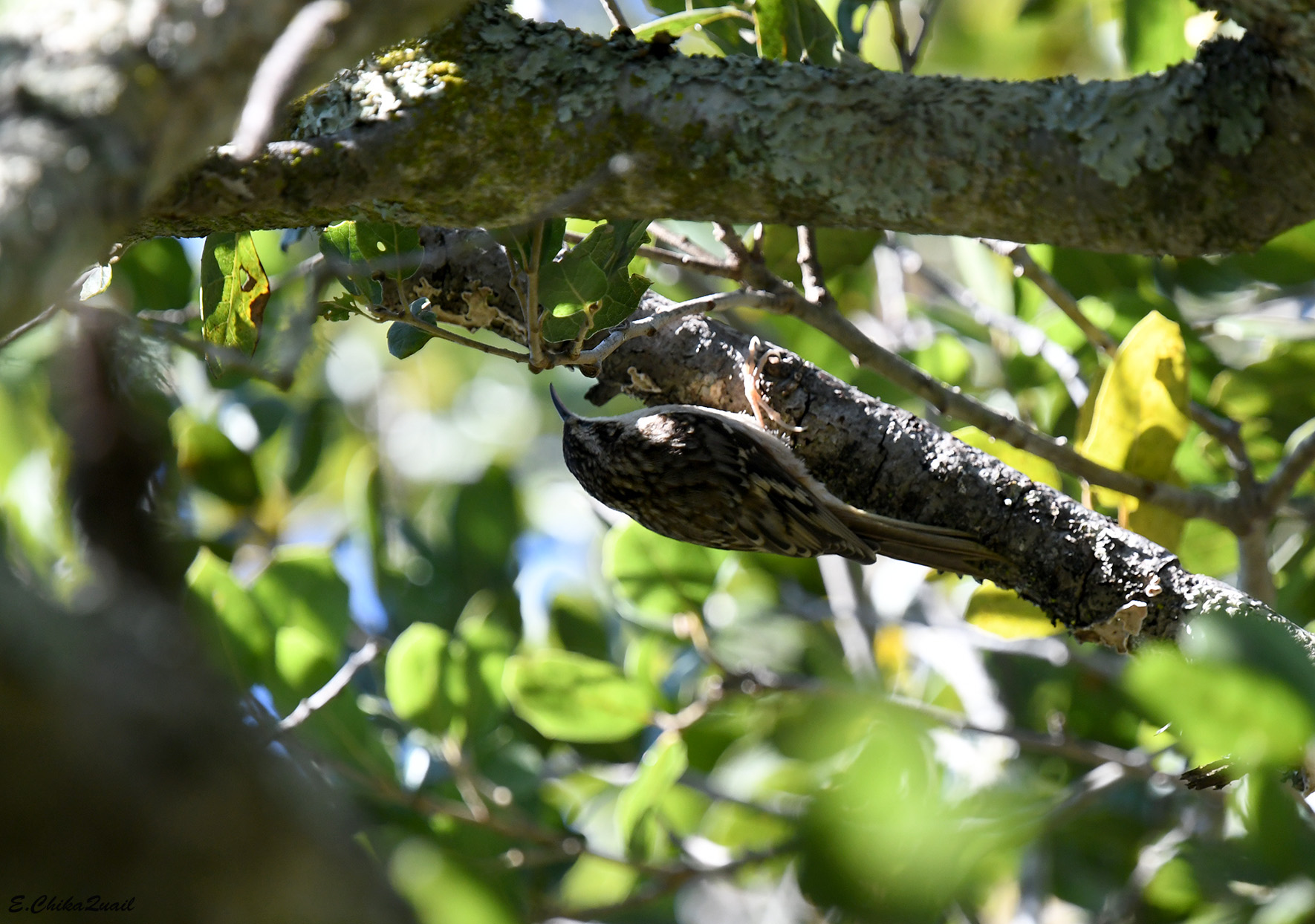
Brown Creeper

Another mushroom attracted my attention - it was brown and well camouflaged among the dry leaves but it was whole and pretty.

We reached the lake shore and doubled back to the north on Bass Cove Trail, along the shoreline. This was the north most end of Lake Chabot - a human made water reservoir, one of the earliest built in the East Bay.  The trail was about 12 ft above the lake, and there was no access to the water.
Bass Cove Trail

I found it funny that at the lake shore there was much less view of the lake than from higher up the trail. 
Lake chabot

We scanned the water surface for birds but all we could see were coots and a few mallards that were resting near the opposite shore.  
American Coot

It didn't take us long to reach the northern end of Lake Chabot. The end was clogged with tall wetland vegetation. A few more coots were swimming between the clamps of tule and horsetails.  

Past the open water there was a patch of very still water that was covered with duckweed - a small higher aquatic plant. It was so dense that it was very tempting to walk on, like a carpet. 

Past the lake the trail continued a bit more inland, following the lower part of Grass Valley Creek. There were plenty of rotting logs and branches strewn beside the trail and many of them bloomed with lovely-looking mushrooms.

The lower part of Grass Valley Creek is probably my favorite part of this loop trail. The path, which starts as a continuation of Bass Cove Trail but changes to Columbine Trail past the turn to the path that goes around the lake, is narrow, and deeply shaded by the arching boughs of laurel trees. I find the laurel fragrance that fills the air and the nostrils very pleasing. The sense of this section of the trail is very wild.

The trail goes right by the creek and crosses it a few times. It was easy enough to cross it on the day of our hike - there hasn't been much rain yet  this season, and the creek was low. I have hiked there though when the creek was running high and it was impossible to cross it without wading in the water.
Grass Valley Creek

My chika pointed out to me a jawbone on the mat of dry leaves. It looked like the jawbone of a deer. There were no other bones of that deer around and it could have been carried there from up the creek, just like the golf balls.

We didn't see any live deer that day, but interesting wildlife doesn't always come in large packaging - a funny looking water-walking insect marched gracefully on the calm surface of the creek. The flow was very slow and hardly noticeable - if not for the lazily moving vegetation particles one could have mistaken this to be standing water.

We found a few more cute mushrooms on the way. When it is off season for the wildflowers, the mushrooms take the colorful reproduction shift.

After crossing the creek back and forth a few times the trail started rising on the hill side, leaving the water flowing down below a deep gulch. There were many tree species growing along the trail and the slope of the gulch, including groves of thin eucalyptus.
Columbine Trail

Below the eucalyptus on the trail were a few dark-eyed junco birds that looked for something to eat. The eucalyptus is an invasive species in California but it had already become an important part in the local habitats. One of the most known beneficiaries of the eucalyptus are the monarch butterflies. I looked, but couldn't see any on the trees we were passing under.
Dark-eyed Junco

The first part of the ascend, on Columbine Trail, was fairly steep but short. The Columbine Trail continued steeply up to meet the Goldenrod Trail about where the golf course was, and we continued ahead on the Cascade Trail, which was now almost flat and much easier to walk. 
Cascade Trail

The Cascade Trail curved along the contours of the hill, high above the gulch's floor where the creek was flowing. In places where the trail was out of the trees we got a nice view of the opposite hillside. Once again those high power lines interfered with the pristine forest view.


One of the trees that I haven't seen many of earlier on the hike was the madrone tree. Poking its canopy above the other vegetation, it's smooth, reddish back glistened in the sunshine.
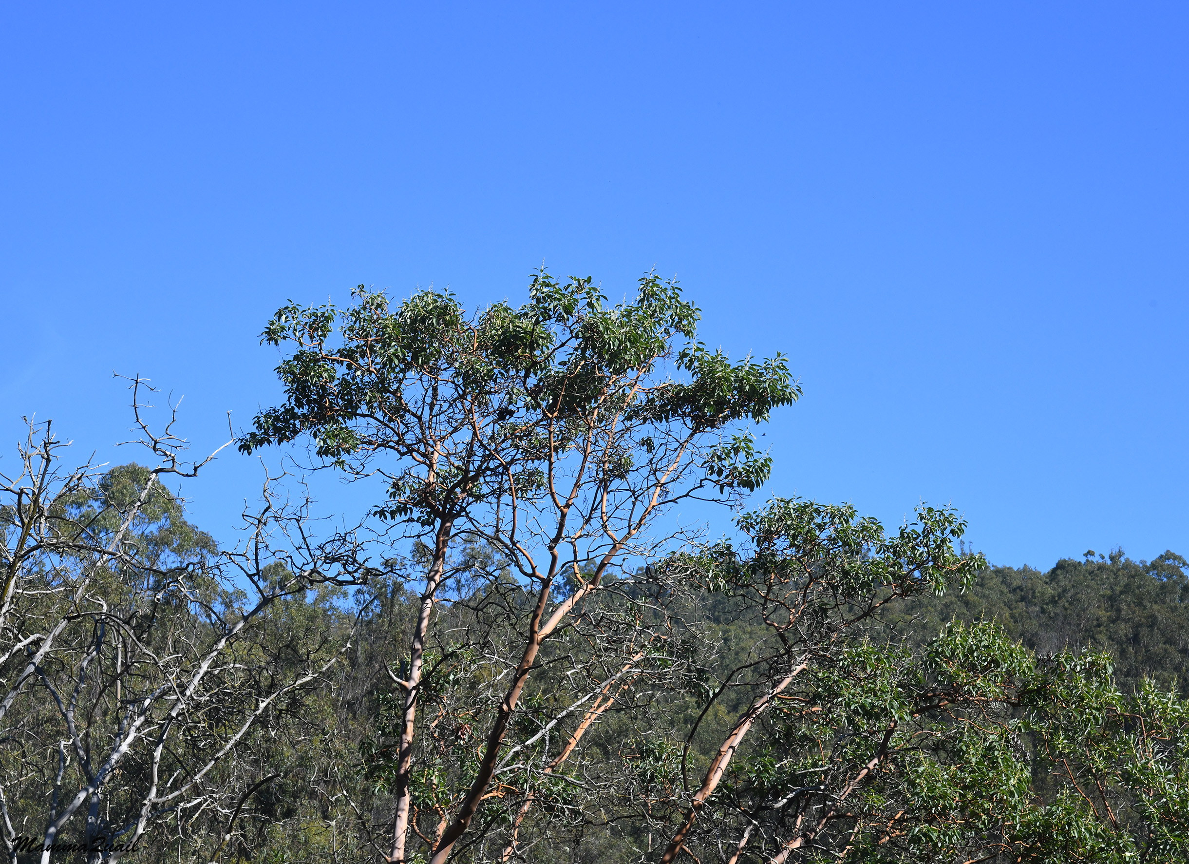
Pacific Madrone, Arbutus menziesii

I came upon a crack in the rock to my left, a crack formed by a widening oak root. I instantly recognized that crack: that crack has caught my attention on my first hike of this trail, and when I took a closer look I saw a garter snake curled below the root. There was no snake there now. Not that I expected to see any out in January.

Up the trail there is a small waterfall. Most of the year the creek (and waterfall) are dry, but now I was hoping to see it flow. I was happy to see that it was flowing, even if a trickle.

It was a short distance from the waterfall to the end of the Cascade Trail. We walked quickly now, both of us eager to finish the hike and have lunch. I paused briefly to admire the pretty white berries of the snowberry bush.
Common Snowberry, Symphoricarpos albus

At the next trail junction we turned left and ascended the short and steep dirt road that led back up to the staging area where we parked. On the way up I admired the "cross-legged" oak tree on the side of the trail.

Just before reaching the top and closing the loop hike was a toyon bush, laden with beautiful red berries. It was a very nice sight to finish our hike with.
Toyon, Heteromeles arbutifolia

My chika and I had collected about four golf balls on this hike. Granted - we didn't look for them, only picked up those that were directly on the trail. On the following day however, the 4-H kids were much more industrious in finding and removing the stray golf balls. We collected nearly thirty balls, some were very old and some looked brand new. We found them all along the trail between the golf course and the lake, and half way up the Columbine Trail. We saw many more golf balls that we couldn't reach so we had to leave where they were. I can only imagine how many of these plastic golf balls are resting at the bottom of Lake Chabot.


Wednesday, May 22, 2013

Coming Full Circle: Around Lake Chabot

Date: April 30, 2013
Place: Lake Chabot-Anthony Chabot Regional Park, Castro Valley, California
Coordinates: 37.71757, -122.10469
Length: 9 miles
Difficulty: Strenuous

I opened this blog on April 2012 and my first entry was about a hike in Anthony Chabot Regional Park. I had planned to go around the lake but was redirected to the lovely Goldenrod-Cascade loop instead.
Last April I finally got to do what I originally had planned: to hike around Lake Chabot. 
I started my hike at the Lake Chabot Marina, walking counter clockwise on the East Shore Trail. Right at the beginning I saw this pretty spotted towhee, singing on a small pine tree:
Spotted Towhee singing in a pine tree
I go often on the East Shore Trail for exercise walks. For 1.7 miles it is a wide paved road that any time of day is shared by other walkers, joggers, bikers, parents with strollers, and anglers carrying their catch. I usually walk to the end of the pavement and back to the Marina.
Nearly always I regret not having taken the camera with me. This hike I compensated for it big time.
Lake Chabot, a view to the north
And the island in the middle - a bird sanctuary. The perfect nesting place for the Great Blue Heron.
Great Blue Heron

Although late in April, the Buckeye tree is just preparing to bloom. The inflorescence looks like candles just before burning. All poised.
California Buckeye (Aesculus californica)
And nearby - an Elderberry tree. I used to notice it just for the distinguishable bunches of blue berries. Now I learned it has a lovely blossom too. The Elderberry was used by the Native Americans for treating respiratory illnesses. It is still used for this purpose today - its extract incorporated in over the counter pills.
Elderberry (Sambucus nigra ssp. caerulea)
And from medicinal to poison: the very common Poison Oak. Ouchy, yet beautiful.
Poison Oak (Toxicodendron diversilobum)
While annual bloom was on the decline, the shrubs and geophytes were going on strong. The hill sides were orange for Monkeyflower bushes in bloom. I chose to post a close up:
Sticky Monkeyflower (Mimulus aurantiacus)
And this White Globe Lily, the common relative of the endemic Mt. Diablo Globe Tulip. There were many of these pretty flowers all along the trail.
White Globe Lily (Calichortus albus)
Small creeks run down hillsides and into the lake. This one I often see running during winter. This past winter I even saw it gashing. At the end of April there was barely moisture in the dirt.

Approaching the end of the pavement of the East Shore Trail one can see large and perfectly round islands of tule. I suspect each started with a single plant which spread equally in all directions to form a perfect circle. These tule islands are perfect hiding places for nesting coots and other water fowl. Kayaking in this water is a good way to approach the bird in an easy, relaxed manner for close observation. This, though, I save for another day.

Himalayan Blackberry is plenty on the slopes by the trail, and in between other wildflowers can be seen.
Fiestaflower (Pholistoma aunitum)
It is nice to see that there is much native vegetation still growing in the park. I am slowly getting to know the local plant species and their origins. The diversity of plants in the Bay Area is just staggering!
Pacific Ninebark (Physocarpus capitatus)
Just past the pavement there is a little box where anglers can get their fishing permits. A pair of Bewick's Wren fancied that box and I sat and watched them for some time as they flew in and out, carrying twigs to build their nest. I informed the park authorities about the bird's activity, hoping they'll put a sign to redirect the anglers to another location for their permits. Wouldn't it be nice if the pair would get to raise their young there? I really aught to go back and find out!
Bewick's Wren in a permit box
The East Shore Trail curves sharply to the left and follows the lake's contours. A narrow bridge is hang there over the creek but the trail widens once more after crossing it. On that side of the lake the area is drier and sunnier. The flowers I see are, in turn, different.
California Wild Rose (Rosa californica) entertaining a visitor.
At this time of year, practically everything in bloom is perennial.
Wooly Indian Paintbrush (Castilleja foliolosa)
Not long enough into the dry season. The greenery is just amazing.  The hills display 50 shades of green. This number is just for the pun of course. In reality, there are at least a 100 shades of green if not more!
50 shades of green
The vegetation on the lake shore thinned enough to see this heron. It looked back at me with some concern but didn't fly away. 
Black-crowned Night Heron
At some point the trail leaves the lake shore and climbs up the hill. I was getting very hot and trying to find the origin of the calls from above the hillside provided a good enough excuse to stop and look around. With some effort I finally detected the caller: a papa quail in the chaparral! 
California Quail, male
I told him I was already spoken for and moved on. The main trail continues toward Honker Bay and that is the biker 12 miles loop. I turned left onto Columbine Trail, which continues along the lake shore, high above it.
The Columbine trail goes below the campgrounds and is basically all in Eucalyptus-dom. There isn't much undergrowth in that forest, save for the ever-present poison oak and a few weeds, mainly thistle. I had planned to have a rest stop at the half way point but the trail there is very narrow and outside of it there was too much hostile vegetation.
After about 6 miles the trail goes town towards the lake and the eucalyptus is replaced by native oaks and laurels. On my way down I was met with loud screams from above: an angry pair of chickadees were shouting at me.
Chestnut-backed Chickadee, shouting with a full beak.
No wonder. They had a nest in a tree hole nearby. I looked inside and saw a few yellow beaks in the darkness. It was too dark to photograph though. I wished success to the parents and moved on, descending toward Bass Cove and the meeting point with Bass Cove Trail. 
The trail leaves the forest on the descend and the birds' shouts were replaced by very different calls: the loud, high-pitch shrieks of the Cicada. It took some effort but eventually I spotted one of the singers:
A singer on a hot green leaf
Amazing how such a small bug can make such a big voice!  
The Columbine Trail meets the Bass Cove Trail at the crossing of the Grass Valley Creek and continues north to become the Cascade Trail. I turned left onto Bass Cove Trail and continued along the lake.
It was like seeing snow in the middle of summer. Very odd.

Not snow, of course. Seeds. Gazillions of seeds. All from this, not very large, tree:
Goodding's Black Willow (Salix gooddingii)
Very pretty when trapped in a spider web. I'm not sure the spider was happy about it, though.

Bass Cove Trail brings me back to the water front and under the trees. The tree cover isn't complete, though. Patches of sunlight filtering through the canopy brings out the beauty of the ferns ... wait. It is the penetrating sunlight that enables this lovely fern undergrowth to begin with!
Bracken fern
In places, there is a clear view of Bass Cove. There I saw these affectionate mother and child:
Pied-billed Grebe
A small group of huge fish that troubled the waters with their spring activities:
Possibly catfish?
And a tired-looking Turkey Vulture, quenching its thirst with lake water:
Turkey Vulture
The Bass Cove Trail follows the lake all the way to the dam. At some point the Goldenrod Trail joins it. I did describe this part of the trail before, but this time I got to see (and photograph) the butterflies!
Common Buckeye Butterfly
This one kept fluttering about. Eventually I did get a clear snapshot:
Variable Checkerspot
Here's the dam that keeps Lake Chabot in place, built in 1874-1875 by Chinese laborers. The lake provided water for residents of San Leandro and the area. It is still held as an emergency water source and swimming in it is prohibited.
Lake Chabot Dam
I crossed the dam and got onto the West Shore Trail, wide and paved as well. There are interesting information panels along the dam and the north part of the West Shore Trail, telling the story of building the dam, treating the water, and the nature of the lake and area. There is also information about Anthony Chabot, the man responsible for many of the East Bay lakes and after whom the lake and park are named.
At that point of my hike I started to hurry. It was almost time to pick up the chikas from school. I did stop to appreciate the trail side flowers, however:
Sitka Columbine (Aquilegia formosa)
I was excited at first to see this one:
Red Valerian (Centranthus ruber)
It colonizes the disturbed areas of the hillside that were exposed by rock slides and gives much color to the bare patches. I did learn later that this species is non native and likely have propagated from city gardens where is is quite popular.

But the best treat of this hike I got just as I was closing the circle, on my last steps before reaching the Lake Chabot Marina. There in the woods I saw an orchid! A Spotted Coralroot that was just beginning to flower:
Spotted Coralroot (Corallorhiza maculata)

The short way around the lake is 9 miles of beauty. I walked it in a leisurely pace and completed the circle at exactly 5 hours. Should have done it for the one-year anniversary of this blog maybe, but I never was good about remembering dates :-)


As I was writing this post I got the urge to go and get another look at the orchids and the wrens, so I went this morning to the park with my camera.
Almost four weeks after my April hike - nearly all the orchids in that patch were done, except one that was still in bloom. Waiting for me, I suppose :-) This time I climbed up the slope of poison oak to get a close up:
Spotted Coralroot (Corallorhiza maculata)

 After visiting the orchid I went to check on the couple of wrens in the fishing permit box.
On my way I saw the Buckeye candles alight with bloom:
California Buckeye (Aesculus californica)
And I was tempted to take a close-up of that too:
California Buckeye (Aesculus californica)
When I got to the box I saw no activity there and no sign that it was ever used for anything but getting the permits. A stack of new little envelopes was in the place where last month I've seen the wrens. Four weeks after - they could have finished their parenting and flown away. More likely that they had had to relocate. Probably better for them anyway.

Many thanks to members of the California Native Plants Society for their help in identifying plants!