Showing posts with label Mammoth Lakes. Show all posts

Sunday, April 30, 2023

Slip-Sliding On Top of the Big Snow: Cross Country At Mammoth Lakes

Lake Mary
 
 
Date: April 14, 2023
Place: Mammoth Lakes, California
Coordinates (of Tamarack Lodge): 37.618382, -119.006832
Length: Vista Loop 2 miles, moderate, and Lake Mary 3.5 miles easy


The winter of 2022-2023 was a record breaker for snow fall in the Sierra Nevada. I was eager to see some of that so on the young chika's spring break I took her skiing at Mammoth Mountain in the eastern Sierra, one of my favorite vacation spots. We took the long route looking for wildflowers on the way, like at Red Rock Canyon State Park, but once we arrived Mammoth Lakes, it was all skiing. Despite the two dry and warm weeks that preceded our arrival, everything was covered by a thick blanket of snow, and huge walls of snow barricaded the town's houses, and the streets looked like tunnels. We planned to ski for five days and following the lovely experience I had in Kirkwood earlier this winter, I decided to take the forth day there to go cross country skiing. My chika immediately announced that she wasn't into it, so I went on my own. On the day before however, I fell hard and bruised my chest but, seeing that I hadn't cracked anything, I decided to go anyway. 
View east from Mammoth Mountain

At the Tamarack Lodge where I rented the skis I also asked for recommendations for easy trails. I'm not a very good cross country skier and I was also hurting from yesterday's fall. The employee directed me towards Lake Mary and seeing that I had a few good hours, I thought to go all the way to Horseshoe Lake, where I hiked last summer with my sister. The day was bright and warm, and the snow was quickly turning slushy in the sunny areas. I was fairly early on the trail so the groomed grooves were still intact and smooth.
At the trailhead

Despite my extensive hiking experience, I do occasionally take the wrong turn. After huffing and puffing up the mild uphill slope, I turned left instead of right at the first junction. By the time I realized I was on the wrong trail it was too late to return, so I ended up skiing the Vista Loop Trail first.  
The Vista Loop Trail

I didn't suspect being on the wrong trail at first. The trail was good and the views were spectacular. I had some issue with the shaded spots under the trees where the top snow was still icy. Watching for the top ice slowed me down but but all and all I made a good progress and enjoyed the winter wonderland in a very spring-like weather.

Later I would understand why this trail was named 'Vista Loop'. From the high pint I could see far into the valley below.

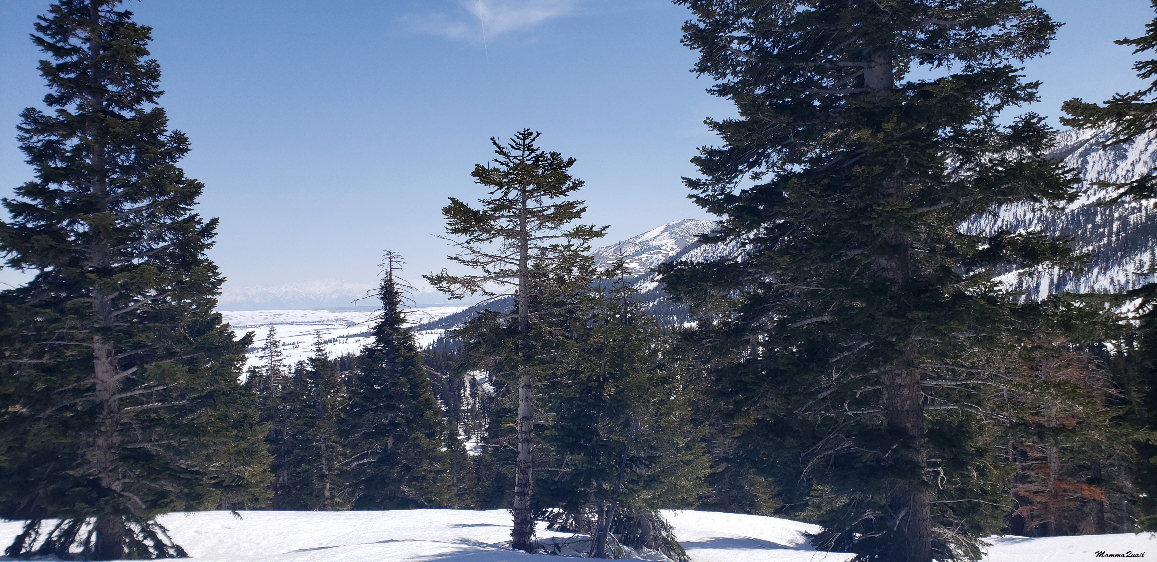
Around the curve I had a good view of the eastern side of the Mammoth Mountain ski area. I could see the thin line of the ski lift and the tiny dots of people whirling down the slopes. I wondered where was my chika now and whether she was having fun, skiing all by herself.
Mammoth Mountain

It was on the downhill part that I started suspecting I was on the wrong trail. I remember wondering how can such a steep downhill be considered a 'green', easy trail. I got hesitant but decided to go for it and let myself go down a long slope on the groomed grooves, praising myself for maintaining my balance even going around the curve. When I cleared the curve however, I saw to my horror a group of people standing there, a short distance away from where the grooves terminated. It was under the trees again, and the snow was icy. Try hard as I could, there was now way I could safely stop before I reached the people so I intentionally wiped out so I won't crash into them. Once again I was hard on the icy snow, and my bruise from yesterday flared up.
Vista Loop Trail

One of the people helped me up. We exchanged some small talk and I went on my way, seemingly okay but with my confidence badly shaken. On the next slopes I simply took off the skies and walked down, feeling a failure. By then I also pulled out the little map I was given and verified that I was on the wrong trail, a 'blue' moderate trail meant for more experienced cross country skiers. I made it down back to the parking lot, having conflicting thoughts. My bruised body wanted me to get back to the lodge and relax for the rest of the day but my bruised ego said no way. I decided to have my lunch in the car and decide after that what to do next. It was funny to see how deep in the snow the cabins near the road were buried. Those cabins that were in use had tunnels dug to their doors and the roofs cleared, but many were still completely covered. 
Cabin near Tamarack Lodge

I had my lunch sitting at the tailgate of my car. I felt much invigorated after eating, and in better spirits. I decided to go out again, and this time on the intended trail.
Lake Mary Trail

The first mild uphill section was the same as before, except the snow was slushier and the sharp contrast between the slush and the still very icy shaded spots was much harder to maneuver. Also the grooves were more disrupted by other skiers. Unlike my nearly solitary experience in Kirkwood, here there were plenty other people on the trail.
Trail

This time I took the right turn, going on the right way to Lake Mary. It was also clear to me that I would not reach Horseshoe Lake on this outing. There wasn't enough time left for me to do that, not with my slow skiing. But I hoped to get at least to Lake Mary.
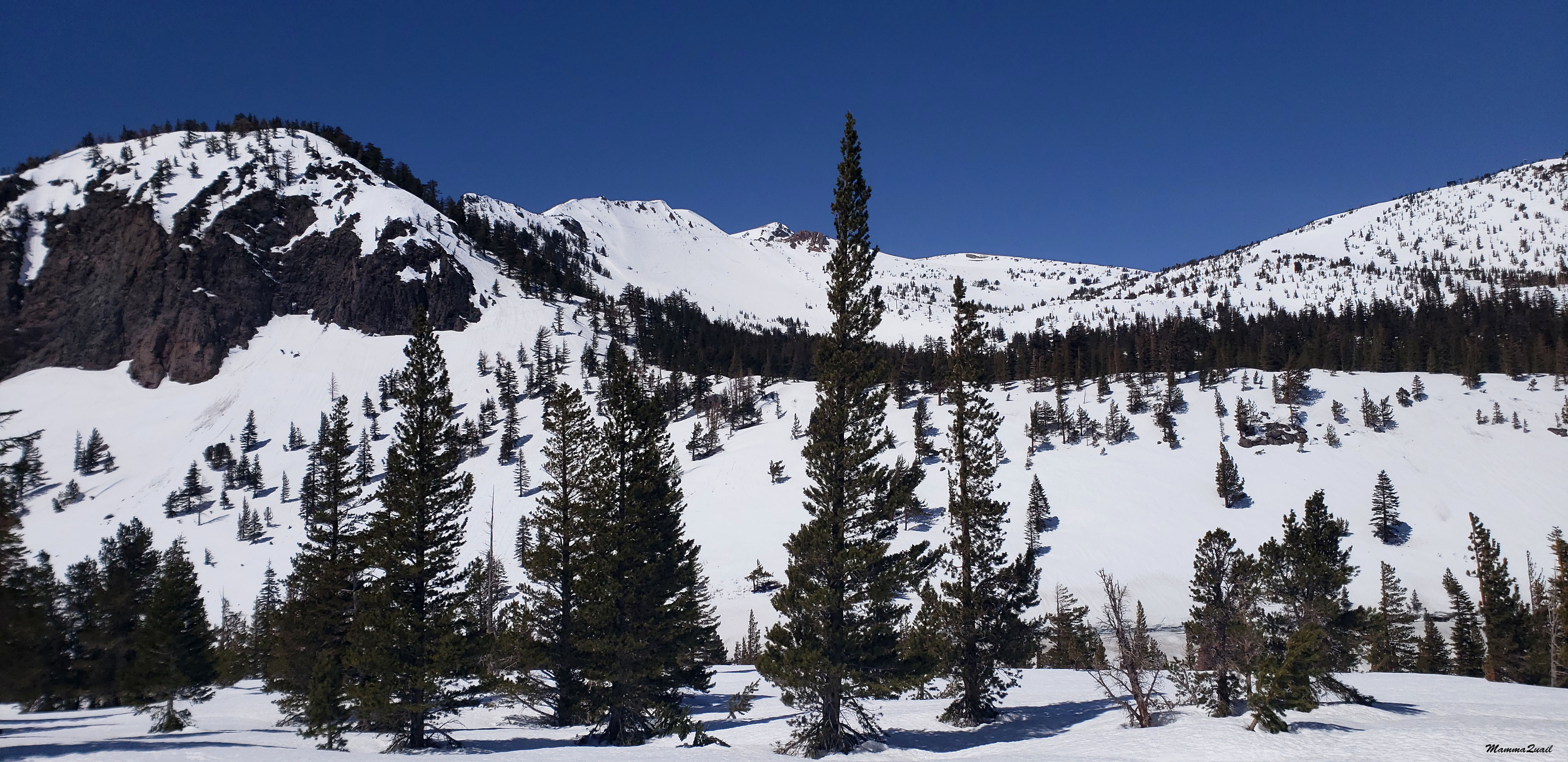
Mammoth Mountain

Mammoth Mountain had a record snowfall of over 800'' but the warm spring weather on the two weeks preceding our visit had thawed about a third of it. The rocks were being exposed quickly and I could almost see the the snow on the steep slopes shrinking away. What surprised me was how dry the exposed soil was. The fresh water was absorbed very quickly.

I don't remember when exactly it dawned on me that the trail I was skiing on was actually the asphalt road that I drove on last summer to get to Horseshoe Lake. The cross country trail system is the road system itself - unploughed and groomed, is was made available to skiers and hikers on snow shoes to enjoy their winter wonderland outdoors.
Lake Mary Road

Perhaps it was when I noticed the permanent road signs that I realized I was skiing on a groomed snow-covered road.
Watch for horses buried in snow ...

My ears picked up the low, and very annoying hum of a drone. The hum kept getting stronger, then weaker, then stronger again. Eventually I saw the thing. It was flying so low I could almost swat it out of the air. I wondered if it was focusing on me, and all of a sudden became very self-conscious about my ungraceful skiing. I looked all around and didn't see the operator, so I waved at the drone, to let the operator know I'm aware of the thing spying on me. I didn't like how that noise interrupted the pleasant winter peace. 
Lake Mary Road

The recreation area sign and the permanent road signs were just being exposed. Next to them was a temporary sign stuck in the snow. I couldn't get over how funny it looked, and how different the entire area looked in summer.

I resumed my slow progress toward Lake Mary, wondering how far I should push myself before turning around. So far I was going on a constant, yet mild uphill. Going back would be downhill, which aught to be faster, unless my poor skill would fail me. While I contemplated all that I saw three young people running down the trail toward me. They wore regular snow boots and were not supposed to run on the groom trail which was for skiers but on the side path saved for hiking and snow-shoeing. When they reached me they asked if I;d seen a drone ... it was theirs and apparently lost. I told them where I've seen it last and as they run past me in that direction I muttered to myself that I hope it got stuck up a tree.

When I finally reached Lake Mary I already knew that I wouldn't have the time to go on the circumference trail surrounding it. It wasn't just the time - the entire south side of the lake shore was forested and I knew the trail there would be icy. Too icy for me to ski on with confidence. There was an opening in the trees where I could approach the lake. I took my skis off and gingerly walked down on the lake's surface.
Lake Mary

It had been twenty five years since the last time I walked on top of a frozen lake, way back when I lived in Wisconsin. I felt the thrill and elation as I made my way to the center of the lake and took some wide shots all around, one of them heads this blog post.
Lake Mary

After taking it all in I returned to the lake shore and stepped into the skis again. I made it to the north end of the lake, then turned around and started my way back down the trail.
There were a nice elderly couple there, that watched me struggle down the first slope. They advised me to do this and that, all of which I already knew, in theory anyway. The problem was that my injury pain flared up and I was already getting tired of the exertion. Cross country skiing is one of the most demanding sports ever, and I wasn't practiced in it, and my muscles were sore. After falling a couple of times coming down a slope that was a tad too steep or that curved inconveniently, I simply took the skis off and walked down beside the trail. Most of the way down however, I did ski, and without any more falls.
Trail

I made it back to the Tamarack Lodge right on time to return the rental skis and to get back to the Main Lodge area where I met my young chika who finished an excellent day of solo down skiing. As I promised her that morning when I sent her off on her own, I now took her to the town's village for ice cream. I was glad of the day's experience and the beauty that I saw, despite the navigation mistake and the ungraceful falls I took. Mammoth Lakes is a hot spot for me all around the year, Next time I'm there in winter, I'll make it all the way to Horseshoe Lake.


Saturday, December 3, 2022

Frozen Holes in the Ground: A Winter Hike to Inyo Craters

Mammoth Mountain
 
 
Date: November 25, 2022
Place: Inyo Craters, Mammoth Lakes, California
Coordinates: 37.681829, -118.994695
Length: 4 miles (including the road to the trailhead)
Level: easy 
 
The chikas have a break from school for the entire Thanksgiving week. Pappa Quail had travelled a lot last summer and didn't wish to go on yet another trip, so I booked a week at Mammoth Lakes for just the chikas and myself. I was optimistic because when I booked this trip there was not an inch of snow yet. Bit we got lucky and a nice snow storm rolled in before we traveled. We skied for five days straight and at the chikas request we dedicated the last two days of our stay there to hiking.
Following recommendations from the Eastern Sierra group, we went to see the Into Craters, a few miles north of Mammoth Lakes, off the scenic loop road.

Our hike as captured by my GPS

The trail itself is less than a mile long, but the road leading to the trailhead was blocked for winter. The snow covered road was nicely groomed tough, and we decided to leave the snowshoes behind and walk with our regular winter boots. 

 
It was a brilliant morning. Chilly at start but sunny and bright. Soon we warmed up from the walk and the top jackets came off.  There was only one more car parked at the blocked road entrance and we met only two people with their dogs on the groomed snow road. The peace and solitude was great. 

While I was interested in the hike and everything that came with it, the elder chika was interested primarily in the local birds. She had specifically asked that we'd spend time in this area near the Minaret Road that leads t the ski resort's Main Lodge because she'd seen a large hawk there on one of the days we came up to ski, and she hoped to see that hawk again. While we didn't see the hawk, we did see plenty of other birds on this hike.  
Mountain Chickadee 

Not all birds fly south in winter, and not all mammals go into hibernation. There were chipmunks and squirrels about, as we could tell from their tracks in the snow. We also got to see a few of the small forest rodents as well.    
Chipmunk
 
We were walking through a primarily conifer forest of pines and firs. Every now and then we'd pass a stand of aspens that were all bare, of course.  
 
 
Little mountain chickadees were active all around us. The elder chika had fun photographing them. Even I managed a few photos but hers came out better. 
Mountain Chickadee

They were hanging down pine cones and some of them dropped down topick something from the snow. Looking closer at the brown specks on the snow I saw that many of them were pine nuts. 
Pine Nut

The roar of engines from behind disturbed our peace. We turned to see a group on snowmobiles coming down the groomed road towards us. We waved to one another and few seconds after, they were gone. Later we run into two more groups of snowmobiles but we were already aware that there was that kind of traffic around and we were watchful.
 
 
The latest snow has been more than a week before our hike but the snow off the trail still looked pristine. White coating covered fallen logs, and pretty much everything. The standing trees however, had already shaken off their load of snow.

 
After less than an hour of easy walk on a groomed snow road we reached the actual trailhead for the Inyo Craters. By the trailhead was a large sign describing the formation of the craters. A oath of footprints in the snow marked where people have walked up and it was then that I regretted not having brought the snow shoes because the snow was deeper and the trail not groomed. We walked on it anyway,going slowly trying to fit our feet into the sunken footprints of the people that had walked there before us. Most of the time it worked but occasionally we sunk into the snow about knee high.
Inyo Craters Trail

The elder chika spotted a red-breasted nuthatch, a lovely little forest bird that we often see when hiking in the Sierra Nevada mountains. 
Red-breasted Nuthatch
 
 The little bird was busy poking into dead tree branches and I wondered if it there were any grubs to be grabbed at this time of the year.
Red-breasted Nuthatch

The person who wrote the recommendation of the Inyo Crater Trail described the crater lakes distinct in their colors, one having blue and the other green water. When we reached the craters the little lakes inside were frozen through and snowed over so no water color was visible. Another thing that we saw when we got to the first crater was a wide, groomed road leading to it from approximately the same direction from where we came. My young chika, who was struggling up the foot path gave my a reproachful look. I shrugged and said that we'll be going down on the groomed trail. 
The south Inyo Crater

We sat on a flat, snow-free rock  near the rim fence and looked down and around. There was no trail going down and the fence was there to keep people from getting too close to the edge. I read the information sign that was posted nearby. It sad that the craters were formed about 500 years ago by steam explosions that happened when rising magma heated the ground water table. A fascinating process.
The south Inyo Crater

I wanted to go take a look at the second crater but the chikas didn't want to go any further, so I left them sitting by the rim rail and went up the groomed trail in the direction of Deer Mountain on my own.
Deer Mountain

The second crater is adjacent to the first one, a bit to the north. On the way I passed evidence that this place is well visited during summer.

The second crater had no fence and I had to be careful not to get too close to the edge while walking on the rim. 

The view down the second crated was obstructed by large pine trees that were growing on the inner slopes of the crater. It is interesting that although both craters were formed at about the same time, one is nearly bare from vegetation while the other is forested. Below, between the trees, I saw the frozen lake of the second crater. Here too, there was no path leading down.
The north Inyo Crater

I looked around for a few minutes, then turned to walk back to the first crater, where I left the chikas. From the rim of the north crater I had an excellent view of Mammoth Mountain. That view alone was an excellent reason to have hiked there.

While I explored the north Inyo Crater, the elder chika was busy photographing a Clark's nutcracker, a type of jay that's common in the high elevation and lives there year-round.

The bird, which usually sits high in the trees, cooperated with my chika and dropped down to sit on a rock by the crater.
Clark's Nutcracker

As I came down from the other crater I found my elder chika stalking a ground squirrel until she got a photo of the pretty little rodent.
Golden-mantled Ground Squirrel

The loud noise of snowmobile engine came to our ears again, and soon two snowmobiles appeared, carrying each a woman and a toddler. We waved to one another, then they continued up to the second crater. I called the chikas and we started down the groomed trail. Coming up the trail were a few more people, but they were much quieter - they were going on cross-country skis.
As it turned out, the groomed trail led us directly to the snow road. We made fast progress from there, taking only brief pauses to sip water and take photos.
Squirrel tracks

A single pine cone was on the snow near the trail. It was perfect shape. It was also open and empty of seeds/ I thought about how many creatures depend on the pine nuts for their living, especially through the winter. The birds we saw definitely depended on them for their survival.
Jeffery Pine Cone

As we made our way back we came across many more people who were making their way on foot or on cross country skis up the snow road. I was glad that we got there earlier and had the morning's peace before the crowds arrived.

I'm sure that on a spring or summer hike of this trail we would have seen not only the crater lakes' colors but also more wildlife and wildflowers too. Winter hiking however, has its own charm and its lovely to walk in the snow and enjoy the kind of hum-free quiet (when no loud snowmobiles are zooming by). Winter wonderland is beautiful.


Thursday, August 25, 2022

Checking Number 1 Out: Hiking around Horseshoe Lake of Mammoth Lakes

Horseshoe Lake


Date: July 12, 2022 
Place: Mammoth Lakes, California
Coordinates: 37.613062, -119.021264
Length: 1.5 miles
Level: easy
 

Lately I've been doing a lot of catching up with my writing of hikes I did in the last couple of years but this one is very recent. Last month my family came over to visit from overseas, and we went on a 2.5 weeks long road trip to Colorado and back. We did a lot of sightseeing and visitations of our relatives on Boulder, but we also did some hiking. Our first hike of that trip was in California still, before crossing over to Nevada. We planned to stay the night in Mammoth Lakes and wanted to spend the time until evening enjoying the Mammoth Lakes, specifically, Horseshoe Lake. 
Beach at Horseshoe Lake


Horseshoe Lake is the highest of the Mammoth Lakes lakes that can be reached by car. I chose that lake because I thought it would be nice to dip in the water. A local woman had warned us that the water is very cold but we went there anyway. The lake was pretty low, exposing a large coarse sand beach to which we went. The north lobe of the lake was very shallow and the water not so cold at all so we took off our shoes and dipped a bit. We settled on a large platform like granite slab and watched the youth playing in and near the water. After some time I felt antsy and decided to take a walk around the lake. My sister jumped up and said she'd join me, and so we left my brother in law in charge of the happy youth and started on the trail surrounding the lake. Where it looks in the image that we walked in the water, it was indeed within the lake's boundaries, but those areas were dry
Our hike as captured by my GPS

The trailhead of the lake-surrounding trail is shared also with a wilderness trail that extends up to the High Sierra and into Yosemite National Park. It starts as a wide, well packed and very comfortable trail.
Horseshoe Lake Trail

A short distance into the forest the trail narrows considerable and starts winding between the trees. Little creeks, running still, flow down from the mountain and the trail crosses them over short wooden plank bridges.

Although my sister and her family were in California for over a week already, this was the first time that we were alone together for any significant time. We took the opportunity to catch up about matters that were too personal to talk about in others' presence or that we wanted to go in more depth than what's is possible when having the children around. All that time we didn't forget where we were and the serene beauty we were walking through.

The trail doesn't go too close to the water, and the low level too makes the shoreline look far. Every now and then the trail wood curve a bit closer and we would get a partial view of the lake through the trees.

There was some bloom along the trail, especially near the little creaks. There wasn't much of it though. I don't know if that was because the year was so dry or because that is usual for the place. I was happy to see flowers though.
Broad-leaf Lupine, Lupinus latifolius

Horseshoe Lake is a small lake, even when it is full to the brim. It didn't take long for us to reach the south side of the lake. As we started rounding the south shore we had a nice view of the northeastern side with the ring of conifer trees, the bare mountains behind , and the looming clouds above. The clouds looked thick but they were far away. We didn't expect to be rained on that evening.
Horseshoe Lake
The south side of the lake was bordering the mountain slope and the trail to the wilderness split off. My sister and I continued around Horseshoe Lake, now going beside some impressive rocky outcrops.

We were walking slowly, chatting, breathing deeply the mountains dry, clear air. An intense heat wave was going on all over the southwest, but in Mammoth Lakes it was quite beautiful, and in the shade if the trees near the lake, the weather was perfect. We couldn't have asked for a better place to be that day.

The familiar mountain heather was blooming near the creeks of the south shore, but the bloom was very limited, not the large pink clouds I'm used to see in the mountains. I guess the second year in a row of a very severe drought had a strong effect on even the hardiest plants of the Sierra.
Brewer's Mountain Heather, Polydoce breweri

We rounded the south shore of the lake and between the trees we could see now almost the entire length of the eastern shore. On the left of the photo - the south eastern slope of Mammoth Mountain coming into view.

Almost every little creek we crossed had some columbine blooming along its banks. We've seen these all along the west and south parts of the trail. They too seemed smaller and fewer than I'd expect for this location on this time of year. The Crimson Columbine is very common throughout California but I'm always happy so see it blooming.
Crimson Columbine, Aquilegia formosa

On the southeastern side of the lake we came upon what looked like an old and no longer used group campground. There was an old oven/grill structure, raised platforms, and old nails and pullies stuck in the trees.

From the old campground the trail veered more to the east and according to my navigator, it would remain distant from the lake until its junction with the lake's access road. We didn't want to get too far from the lake so we left the trail and maintained close proximity to the water.

It was obvious that many others did the very same thing because even off the trail there was a trail, even if unofficial. It meandered between the trees and pulled closer to the lake and we followed it.
 
Eventually we came out of the trees and slowly descended the scree and gravel slope towards the water. Just ahead of us, looming above the lake was the majestic Mammoth Mountain. I'm used to seeing it covered with snow but now it was completely naked. Across the lake I detected a patch of dead trees and I trained my camera on that patch.
Mammoth Mountain

The local woman who told us about the lake also told us about the dead trees near it. These trees didn't die of the drought or of any pest or disease. These trees were killed by carbon dioxide emissions from the mountain itself. Mammoth Mountain is an active (although dormant) volcano and emits gasses from its depths. Carbon dioxide is heavier than air and concentrates low by the ground, where it can accumulate to deadly levels, suffocating aerobic organisms. The locations of the gas emissions can change, and when carbon dioxide was emitted in this spot near Horseshoe Lake, it killed the trees in that area.

We came down closer to the water, walking slowly on the rocky ground, careful not to slip and also careful not to trample the few wildflowers we did  see on the scree slope.
Phacelia sp.

Although not an official trail, we did find an established path right by the water along the east side of the lake. We continued north on that path, heading toward the mountain. We tried The sun was getting low, soon it will be time to go for dinner. 

The makeshift path was clearly in the zone that would have been covered by water had the lake been full. There wasn't much vegetation growing there, and the plants that I did see were all quick-growing species, many of them annuals. Of these I liked best the little sedges and grasses that bloomed beneatrh the larger rocks.  

From the east we had a nice view of the flat top mountain southwest of the lake, and of the rocky outcrops that we had walked past, some that were down all the way to the water. The low sun made it hard to see details on that slope. 

A rocky ledge and some large scree protruded from the forest all the way down to the water. We followed the makeshift path back up toward the trees where the walking was easier. We didn't enter the forest again, we simply walked along the tree line. It was interesting to see that the trees that had the low branches, had these branches growing downward. I assume that's the effect of heavy winter snow weighing these branches down. 

Past the rocks and scree we went back down to the lake shore and resumed our walk by the water. We could see our youth gathered by the same large rock we stopped at in the beginning. My sister spotted her spouse lying down on the flat part of the rock. He seemed to be asleep. I noticed the pretty grasses that grew by the rocks near my feet. I also noticed the water lines painted on those rocks, an indication of how high the water was not so long ago. 

As we were closing our hike I went up a bit to look closer at the suffocated dead trees. That entire patch looked like a sad boneyard. This death however, humans had nothing to do with. It was Mammoth Mountain's reminder of its role as the dominant force shaping the region. 


We completed the round around Horseshoe Lake and rejoined the rest of the family. The kids were ready to go for dinner. My brother in law said he could have slept longer on that comfy rock bed. It looked like everyone had a very nice time that afternoon. I know I did, for sure.