Showing posts with label March Desert Tour. Show all posts

Friday, October 4, 2013

The Calm After the Storm: Hiking Up Pyramid Canyon

Date: March 9, 2013
Place: Death Valley National Park, California
Coordinates: 36.37250, -116.66552
Length: about 3 miles in and out
Difficulty: moderate

The morning after the storm my friend and I woke up to a crispy-clear morning. We had stayed the night in Death Valley Junction (south-east of the park) and the mountains all around were capped with fresh snow.
After a quick breakfast we headed westward on hwy 190, back to the park. It was just before entering the Amaragosa Mountain Range that we run into our first excitement of the day: a small group of wild horses, grazing lazily between the road and the mountains. Naturally, we stopped and observed them for some time.

Wild Horse
On the previous day we were told at the visitor center that there are wildflowers along the hwy 190 stretch that crosses the Amaragosa Range, so we had planned to hike up Pyramid Canyon. The instructions we had were not the clearest and we had spent some time going back and forth the same 3 miles of road until we decided we were at the right place.
The hike from hwy190 into Pyramid Canyon is labeled yellow
As it turned out, we indeed were at the right place, and for the benefit of future hikers: the coordinates are at the top of this post.
The Trailhead of Pyramid Canyon
We got out of the car and immediately saw the wildflowers we were told about:
Phacelia crenulata
All were very small, but there were many of them: 
Camissonia brevipes (Yellow Cups)
And they were not at all inconspicuous:
Mimulus bigelovii (Bigelow's Monkeyflower)
After the somewhat-disappointing display of the west Death Valley bloom we were thrilled to see the spectacle of colors on the canyon's alluvial fan.
Mohavea breviflora (Golden Desert Snapdragon)
There isn't really a trail there nowadays, but apparently, there used to be a road there a while ago. We saw the evidence in old metal posts along the wash bed, and in one rusted vehicle, half buried in the gravel. There were plants growing inside it, and clusters of little, perfectly round holes indicated that this vehicle had been used for target practice by armed wayfarers.


No real trail, and for 1 mile there's no canyon either, just a slow walk up the alluvial fan and appreciating the view ahead:
Pyramid Peak, wearing fresh snow
and the view back:
The Amaragosa Range south of hwy 190
And the vegetation:
Echinocactus polycephalus (Cottontop Cactus)
One of the plants made us stop and observe more closely. This Coyote Melon bush was completely dry except for its fruit: round spheres of promised juiciness. It was clear that someone was enjoying this bounty of moisture, because some of them were ripped through and eaten.
It is not called Coyote Melon for nothing, although several species eat the fruit of this plant. Apparently, it is very bitter and not edible to people. Native Americans used it to make gourds and soap.
Cucurbita palmata (Coyote Melon)
In contrast with the constant chirping at Darwin Falls, Pyramid Canyon was eerily quiet. We saw maybe two or three birds the entire hike and only one of them sang, as if to taunt us. Well, camouflage ot not, I did manage to photograph this one:
Rock Wren
After nearly a mile of mild scrambling up the wash's gravel we arrived a splitting of ways, marked clearly and naturally by a large rock on which grew a large creosote bush. We turned to the right, where the opening of the canyon itself was visible through a gate of lovely pink rocks.


As the canyon walls closed in on us, the rock formations appeared more and more interesting. I took many rock photos that day, but I only present this one here:

I wonder what is the geological story behind those layers.
At some point, the canyon opened up a bit and there, on the rocky ledges, we spotted a group of interesting shrubs. We observed them closely and took photographs. Non of them were blooming at the time. Later, my friend found out that this plant species is rare and endangered. A good encounter indeed! 

Mortonia utahensis
About half a mile up the canyon our way was blocked by large boulders. It was time to turn back.


But not before I climbed this obstacle and looked at the next one, an even higher boulder block, upstream:

On both sides were sheer walls, and from various spots in the walls, water was seeping out. The exact point of spring water.

I climbed down and rejoined my friend and, after a short break we started back down the wash. We were all alone during that entire hike, not seeing any human, and hardly any other wildlife. It was very tranquil, and the weather was perfect. And we did get to see some desert flowers after all :-) 
Mortonia utahensis


Many thanks to my friend, עננת for identifying the plants. Thanks also to Papa Quail for identifying the rock wren.


Wednesday, September 18, 2013

Riders on the Storm

Date: March 8, 2013
Place: Death Valley National Park, California

Out in Nature, away from the shelter of home, one gets to experience its force in full. In Death Valley it is most commonly the force of extreme heat. But sometimes the desert flips and shows its thunderous side. And when it does, it is no less extreme ...
This is not a hiking post, just photographs taken on that stormy day on March, after our visit to Ubehebe Crater.
On Scotty's Castle Road, due south. 
The rain itself wasn't all that intense. Not in the valley below, were we were. On the surrounding mountain ranges though, it was a different thing.
Panamint Range donning white, view from Scotty's Castle Road. 
We reached Hwy 190 and continued driving south toward Furnace Creek. For some time, the hills to the east were completely invisible.

It is well known that prime desert hazards are heat stroke and dehydration. Flash floods, however, is a prime cause of fatalities as well. Better not get trapped in a canyon when the mountains above are getting a soak.


Most flash flood fatalities, however, occur in vehicles. It is easy to underestimate the power of running water. Having grown up in the desert myself, I've seen it too: upside down cars, even large trucks, stuck in the mud because their drivers thought they could cross the flowing wash.
This Jeep crossed just fine, no fatalities here:-) 
The storm didn't last very long. about two hours, maybe. The clouds still hung over the mountains, but late afternoon sun found its way to the lower slopes.

The contrast could not be any sharper: the Mustard Hills, bright yellow in the late afternoon sun, under the looming snowy and dark Winters Peak. My friend and I stood there at Harmony Borax Works and photographed this inspiring view again and again until the sun had hid itself again and both landmarks fell under the shadow.
Mustard Hills (in front) and Winters Peak.  
But it wasn't just eastward that I pointed my camera too. The low setting sun is particularly good in bringing out the contours of the mountain slopes.
Telescope Peak (or Wildrose Peak?) view from Harmony Borax Works.
The sun was setting fast. After some wandering about in the Mustard Hills we got back into the car and drove to Death Valley Junction, where we would spend that night, getting ready for the big hike we planned for the morrow.
Evening sky in Death Valley, March 8, 2013


Sunday, September 15, 2013

A Hole in the Ground Where the Wind Does Not Go: Inside Ubehebe

Date: March 8, 2013
Place: Ubehebe Crater, Death Valley National Park, California
Coordinates: 37.01083, -117.45490
Difficulty: strenuous

On the morning my friend and I had left Panamint Springs, the looming storm was still looming. After spending some time looking for wildlife around the ghost town of Ballarat we headed eastward over the mountains and into Death Valley itself. By then, large raindrops were falling and the smell of first rain (in the desert almost every rain has that first rain smell) filled the air. Of the bloom spectacle I promised my friend, there was no sight. The valley, however, was not barren. Little yellow flowers dotted the wide gaps between the Creosote and brittlebush shrubs: Desert sunflower, all over the place!

And up close. The lively bright yellow was a much appreciated sight in the otherwise pre-storm glum. The little suns on the earth made up well for the hidden sun in the sky!
Desert Sunflower (Garaea canescens)
I've been to Ubehebe Crater twice before, and even wrote about it here. I wanted to show it to my friend also. My plan was to walk around the rim. The wind, however, was so gusty and strong that we soon abandoned that idea. Instead, thinking to find refuge from the wind, we wend down the cinder trail into the crater itself.
The trail to to the bottom of Ubehebe
There is no hiking trail inside the crater. Once down (and away from the wind) we simply wandered about, looking for interesting sights, and easily finding them. I was impressed by the layers of packed volcanic ash that make the colorful eastern wall of the crater.
The eastern wall of Ubehebe
Run-off water had cut narrow crevices into the crater walls. It was very tempting to squeeze into them and see how far back they extended.

None extended very far. Still, it was an interesting experience.
The trail and the western crater wall, viewed from inside a crevice
 The crater is a basin with no way out. Run-off water evaporate, leaving a flat and smooth surface at the lowest part of the crater. At this place, where water is last to leave into the air, the Creosote bushes are the largest and lushest. Right there, these bushes are as tall as a person.

Surrounding the evaporation plain, the bottom of the crater is strewn with colorful rocks that make a pretty mosaic between the Creosote bushes.

And not just the rocks are colorful there: the unassuming grayness of the desert holly shrub is dotted with scarlet flowers.
Desert Holly (Atriplex hymenelytra). Photo by עננת
 Taking Papa Quail's advice, I am adding here a rim photo of Ubehebe, to give a proper scale of where we've been on this visit. I missed taking a rim photo on this visit, so this photo is pasted from my previous hike there, on October 2011.
Ubehebe - an almost full view. Taken on October 2011.
We wandered for a good hour at the bottom of Ubehebe. Going back up was not easy: the cinders trail takes much effort to ascend and the wind increased with every step upward. We didn't stay long at the top. huddled in our winter clothing we escaped into the shelter of the car and continued south to Death Valley, facing the on-coming storm.  

Many thanks to my friend עננת for identifying the plants and for allowing me to use her desert holly photo.


Friday, September 13, 2013

The Desert's Lifeline: Darwin Falls at Panamint Springs

Date: March 7, 2013
Place: Panamint Springs, Death Valley National Park, California
Trailhead coordinates: 36.32756, -117.51471
Length: about 2 miles in and out
Difficulty: easy to moderate (involves some rock scrambling near the falls).

The winter of 2012-2013 has been by big desert winter. After touring the desert parks of Anza Borrego State Park, and more desert parks in Imperial and Riverside counties over winter break, I was ready to travel south again: this time with my botanist friend from overseas.
"Come in March and I'll show you the spectacular desert bloom!" I told her, back in Fall. I also suggested camping in the desert, and my friend was concerned that it might be too cold for that.
"Cold won't be a problem," I assured her. "Not where we're going, not on that time of year."
So my friend arrived, and as it turned out, I was grossly mistaken on both accounts. After a relatively dry winter, there were very few wildflowers about and the week we were there turned out to be the coldest of that winter. That taught be not to promise anything that's beyond my control (although I was ready to promise anything so my friend would come to visit, and my predictions would be accurate any other year ... )

Either way, I left the chikas in the excellent care of Papa Quail and took off with my friend into the vast California desert.
Snow-capped Telescope Peak, viewed from Father Crawly Vista
All of my previous visits to Death Valley National Park, I somehow managed to pass Panamint Valley on my way to the more popular attractions of the park. This time I added it to our tour plan and I am very glad I did so :-)
Cottonwood Mountains Northeast of Panamint Valley, viewed from Father Crawley Vista
Panamint Springs is a small resort in Panamint Valley, inside Death Valley National Park, just west of Death Valley itself. There's fresh water there. Precious spring water in the middle of a vast desert that sustains that tiny resort of Panamint Springs. Lucky for us, we got there on time to book nearly the last available room in the resort. There is the campground there too, and that's where we sat down for a picnic lunch, admiring the beauty of the sparrows that hopped about.
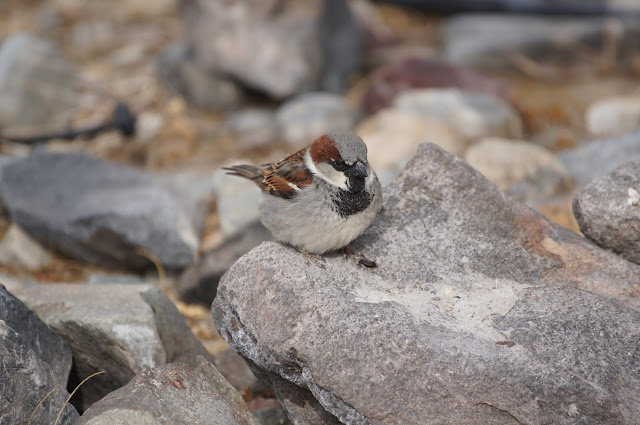
House Sparrow, male
After lunch we drove the 2-miles dirt road to the trailhead to Darwin Falls. Along the way we saw the thin, white pipe: the lifeline of Panamint Springs from the only fresh water source in the area.

The dirt road continues beyond the trailhead and onto the hills. We parked and entered the Darwin Wash. Not quite spring yet, but the silvery cushions of brittlebush were in bloom.
Brittlebush (Encelia farinosa)
Other shrubs added their bright colors to the desert brown:
Pygmycedar (Peucephyllum schottii)
But even the desert brown has many shades and colors. These tell of the natural history of the Earth there at that spot:
A dike: a sheet of magma that rose in a rock crack and froze there, exposed by the wash water
The water pipe was going along with us, all the way to the source. With so little water available, every drop consumed by people is a precious drop less for the wild. A fine balance it is, to use and not destroy. The pipe wasn't completely tight and at some points, some of this precious water was returned back to the wild.

About that point we also met with the natural water flow of the Darwin Wash, all covered with algae:

After about half a mile the canyon was closing in on us and lovely lush willow trees filled the gap between its rocky walls. My spirit swells at the sight of the lush green against the bare desert scenery.
Salix sp.
But no one could say that desert color comes only from plants. In the desert, the rock itself is alive with color!

But the plants do add to the color splendor. Some were easily approached,
Emory's Rock Daisy (Perityle emoryi)
And some we had to admire from afar.
Hedgehog Cactus (Echinocereus sp.)
A fern in the desert. What a luxury! It marked the cracks in the rock where water was seeping from the ground.
Maidenhair Fern (Adiantum capillus-veneris)
And just above the fresh water source, a beavertail cactus growing on completely dry rock.
Beavertail Cactus (Opuntia basilaris)
Along the creek we saw numerous plants that one would not find in the area at all if not for the springs.

And lucky for us - a few of them were in bloom.
Golden Suncup (Camissonia brevipes)
As for wildlife, the chirping of birds was everywhere to be heard. Seeing them, was another matter altogether. After much patience, I managed to get a clear view of one of the happy singers: a Yellow-rumped warbler:
Yellow-rumped Warbler
Their nests are stationary, making them an easier subject to photograph.
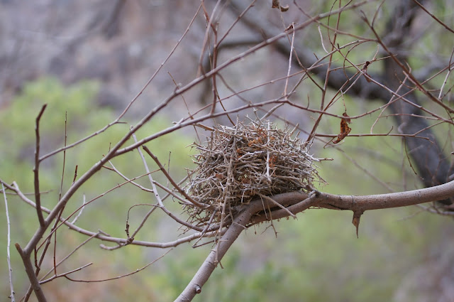
Yellow-rumped Warbler's nest
Some of the birds can be difficult to see because they hide in the vegetation. Others are difficult to see because they blend in their surroundings, wearing perfect camouflage:
Say's Phoebe

Some birds, however, stand out proudly in full color, like this lovely robin who stood his ground and allowed us to get quite near for a photo:
American Robin

We kept on going toward the falls. At that point the comfortable trail becomes hard rock and we spent considerable time jumping from one side of the creek to the other to find good footing and to keep our shoes dry and our clothes clean of thorns.
Scrambling to the falls
There is an abundance of beautiful waterfalls in California, many of them are very impressive. Darwin Falls is small and modest but, like in many other things, it is all about location. Being where it is, Darwin Falls is one of the loveliest waterfalls I've seen in this state.
We were alone there, my friend and I, and had it not been so cold and windy, we probably would have enjoyed a swim in that little pool under the waterfall. But then again, had it been hot and sunny, we probably would have had to share the sight and the fresh water with other hikers.
As it was, we enjoyed the solitude and the pure sound of falling water and chirping birds.
Darwin Falls, named after the American Adventurer Darwin French.
The sky was getting dark, and not just because it was getting late. After a long rest my friend and I hoisted our backpacks and headed back down the wash. Ahead we could see the heavy clouds moving in. It was time for to get back indoors.
Signs of on-coming storm

Many thanks to my friend, עננת for identifying the plants!