
 |
| The Eye in the Sky |
Day Two: Up to the Summit and back to the campground: 4 miles round trip 6000 ft elevation difference
In my youth when I went camping in guided groups we used to wake up to the banging of pots and pans. It is a cruel, albeit very effective wake up call. Thankfully, our guides had a much gentler, yet just as effecting way of waking us up: they stood over our tents and started harmonizing a song. Softly at first, then crescendo to a volume loud enough to get us grunt out our freshly awakened state. I have a very light sleep so I was already awake when the guides started their singing, and by the time they finished, I was already dressed up and outside of my tent.
Breakfast consisted of a hot beverage and a serving of oatmeal. We had already filled our water bottles and prepared our packs the evening before so all that was left to do was to place the headlamps on our helmets, then place the helmets on our heads, on off we went up the mountain.
 |
| From the campground to the Summit and almost (the GPS battery run out) back. |
We begun hiking up about 3:00 am and for the first couple of hours it was too dark to take any photos. Just as it was the day before, we were to walk at a very slow pace and take a 10 minute break every hour, and we were should eat, drink, and void, if needed. Following our guides advise, I kept my puff jacket right under the hood of my backpack so it'll be a quick grab when we stopped for our break. I needed it too, because as soon as we stopped walking I immediately got cold.
There were plenty of other expeditions ascending that morning. Some were above us and others below. At one point I turned around and snapped a few photos, not really expecting any of them to turn out. This one I like, however. The long lines of headlamps captures in slow exposure of the group ascending just below ours.
I didn't have my headlamp on at all. From my place in the middle of the hikers line I found that their headlamps were quite sufficient to illuminate my way as well.

It was only around 5:30 am that the dawn light was enough for a good photo. The light coming from the east painted the western horizon in dim orange, and the rock fins I've noticed yesterday turned red.

We were walking uphill when the sun finally cleared the eastern horizon. The guides didn't say anything when we paused briefly to take photos and admire the beautiful dawn.
 |
| Sunrise |
Looking back to the east I saw our shadows, distant and long, cast by a small snow patch. It was sad that the mountain was nearly bare but the sight was beautiful nonetheless.

Way up high the summit was turning red with the first light of day. Snaking through the scree were other climbers, toiling upslope. There were many behind us as well. I was very proud of myself for being able to keep up with the pace set by our guides. I thought I could go faster yet, but I figured that would be a mistake, seeing that we had much more elevation to gain.

Our guides kept trading places after each lag of the hike. Following each stop, the leading guide would let the other take the lead while he would bring up the rear for the next lag.
Far below to the west there was a large monument of bare granite peaks. Those, I recognized, where the Castle Crags. I hiked many times in Castle Crags State Park, always the short, readily accessible trails that are easy to to on a short break on very long drives. Castle Crags has never been its own destination for me. Now however, as I looked down at the awe-inspiring mass of granite I felt that it might be high time to schedule a camping trip to that park and explore it more thoroughly.
 |
| Castle Crags View |
We sat down for yet another break and watched other groups pass us by as we munched on our snacks. A squirrel popped from between the volcanic rocks and eyed us with interest. It knew what it was looking for, and sure enough, we soon had to scare it off from our backpacks. It looked well fed, too well fed, in fact, which is pretty sad. It means that people leave trash behind or maybe even deliberately feed it and its relatives, something which is a big no no when going into the wilderness.
 |
| Golden-mantled Ground Squirrel |
Another break was over and we continued toiling upslope. Even at a slow pace going up that trail was hard work, and not only because of the altitude: going up a scree slope means a lot of wasted energy. The scree is soft and slippery and absorbs much of the energy of the step, and forces the hiker to put more effort into the upward motion than she would going up a harder surfaced trail.
I faired reasonably well. When asked by the leading guide how I was doing I replied that as long as I could talk while walking it meant that I was just fine with that pace. 

One must keep in mind that the trail we were walking on was not an engineered and maintained trail. The natural state Mount Shasta at this altitude is snow-covered. In any other year we would be treading snow, a surface that presents different type of challenges.
In any other year however, I wouldn't be seeing the exposed volcanic formation that Mount Shasta has. "Thumb Rock" was one of these formations: a pretty colored layers of volcanic deposits. Behind 'The Thumb' was a small patch of glacier. We didn't get close to it and I was glad for having taken my good camera along, despite its weight.
 |
| "Thumb Rock" |
I kept checking our progress on my navigator. It felt as if we were moving at the pace of a tortoise. Like when driving, it seemed as if everybody else were walking much quicker, and passing us. I was grateful for our slower pace though, because it soon became more difficult for me to chat while hiking. The strain and altitude were now affecting me. 

Time passed and we were making distance step by step. A gap formed in our group as one hiker was affected by the altitude and slowed down. I've gone quiet now, because keeping the pace of the lead guide took all of my breath, leaving nothing to vocalize with. I was still in high spirit though, and every glance down the slope showed me how high we really were. Although our pace was slow, we were ascending for sure.

For the most part, the scree slopes were bare. Not that I expected differently from a place that is is normally covered in snow at this time of year. Still, there were some flowers here and there and my group mates made sure that I didn't miss any.
 |
| White-flowered Sky Pilot, Polemonium pulcherrimum var. pilosum |
I tried to not look uphill too much because it looked daunting. It was mid morning already and it looked liked we weren't even half way to the summit. The guides seemed to have slowed down our pace too. One of our group had some difficulties keeping up. I too felt shorter of breath. Joey, one of our guides had taught me how to power-breathe and I found it helpful. Still, I avoided speaking while walking up.
Our guides pointed out a landmark rock which they called the Doghouse Rock' and told us that's where we'll have our next break.
 |
| 'Doghouse Rock' |
There were people coming down the mountain. Some of them were climbers that found the ascent too much for their abilities. Others yet, had already summited, and were gliding down the scree slope wearing a big grin. They had slept in campsites much higher up than where we were. These campsites had no water near them though, and I didn't think they could have relied on melting snow because the little snow patches remaining were nowhere near the trail. They must have carried all of their drinking water on their backs.

One of the other groups that we kept leap-frogging with had three Israeli tourists - an elderly man and a woman with her near adult son, about the age of my older chika. I have met them the day before so I knew they were visitors from overseas and not immigrants who lived here, as I am. They were very energetic to begin with but by the time we reached the Spaceship Rock, which was our last stop before reaching the 'Death Wall' it was clear that she wouldn't be going on. I saw that our guides were conversing with the guides of that group. Then they came back and asked us how did we feel, stressing that our safety was the top priority of this trip. I felt fine and was ready to go on and so were two others of our group. The forth, the one who was slowing down earlier, decided that he'd do best turning around and heading back to camp. One of the other group's guides would be going with the tourist mother and our guy would join them on the way down. It was the safe choice.
It was only on our way down that I our guides shared that they named these landmark rocks as they saw fit at the moment. To be sure the names, it fit very well, and were very amusing.
 |
| The 'Spaceship Rock' |
It was from that spot that I captured my best photo of Lassen Peak. Lassen Peak, my favorite Cascade volcano was visible throughout the climb but the haze was so bad that most of my photos came out terrible. Even this one I had to clarify considerably using my photo processor.
 |
| Lassen Peak |
At the bottom of the Death Wall we were instructed in how to ascend the very narrow path up the almost sheer volcanic rock wall. The poles were of very little use here so I collapsed them and hung them on my wrists. There were three of us now, and I was smack in the middle, following carefully, step by step, along the route that the lead guide had taken us on. Here too, there was no official, established trail. Rather, the wall had numerous little trails, each of them evidence of someone thinking that might be a good route. Although our guides did not fill our heads with horror stories, they did acknowledge that accidents on the wall did happen every now and then.
About half way up the wall the other adult tourist in the other group was ready to bail out. The problem was that the youth which was fully capable to go on, had only basic English skills. It was enough for a simple conversation, but not for more complex communications. I was pulled to the side and asked if I would be willing to be a translator should the need arise, and I agreed. The second guide of the other group went down with the adult, and the youth, and another adult (American) left in that group joined ours, and we continued on.
 |
| View from The Wall |
On top the Death Wall we took another break. Above us, not very far now, was the Summit Pinnacle. We needed to go across the summit Plateau and get to the pinnacle from its other side.
 |
| The Summit Pinnacle |
From where we were sitting I saw on the west another area of high peaks. Not as high as where we were, and not even as high as the High Sierra but I recognized it immediately - those were the Trinity Alps. I had a few day hikes there and I'm yet to go on a backpacking trip in what is supposed to be one of the more enticing wilderness areas in California. Our guides told us they were planning to go backpacking there themselves later that summer.
 |
| The Trinity Alps View |
At the Summit Plateau we finally reached snow. It was old, dirty, and very uneven, but we didn't need any special equipment to cross the snow field which covered the plateau.
 |
| The Summit Plateau |
At last we reached the Summit Pinnacle. The guides had already told me not to expect a caldera and indeed there wasn't any visible one. Mount Shasta is a stratovolcano, meaning it had complex eruptions that don't necessarily form a textbook image of a volcano, even if seen from below it does look like one.
 |
| The Summit Pinnacle up close |
On our way around and up the summit pinnacle we came by the fumarole area. The fumaroles emit the sulfur-smelling volcanic gasses, an indication that the mountain is very much alive, only dormant for the time being. Other than the yellowish soil the fumaroles weren't very distinct to the sight. The odor however, was pretty strong, and a low rumble sounded from underneath the surface.
 |
| Fumaroles |
Summit at last! The last lag going up the pinnacle was pretty crowded and the small area up the summit was full of people, so I didn't take many photos of the summit itself, and I post none here. I did go to sit on the top most rock and asked one of our guides to take my photo there. After that I took some photos of the view from the summit. I felt great! I was literally on top of the world! I signed the summit log and received my summit pass from the guides. I felt elated. All the hard training I did had paid off - I made it to the summit of Mount Shasta, my first (and so far only) 14000er.
 |
| Mount McLaughlin View from the Summit of Mount Shasta |
We didn't stay at the summit very long. Although we had the longest break there it was soon time to head back down. It was already past mid day and our guides didn't want to linger there. It was going to be a long way down, they said, and at that point I didn't really realize how long it was in fact going to be.
 |
| Another view of the Summit Plateau |
As we crossed the summit plateau on our way down I noted again the sad state of the mountain's snow cover. Another member of our group had shared with us earlier that a friend of hers, of the Pit River Tribe, had told her of their belief that if Shasta ever got bare of all snow, it meant that the end of the world was coming. Well, it was very close to that state when we were there, and the ominous feeling of a looming disaster was present, and would have been even without having heard the story. This was not right.
What did come in time was the annual butterfly migration. Clouds of tortoiseshell butterflies were swarming around the summit plateau, fluttering and toying with the high mountain air currents. I've seen their migration swarm before, near the summit of Lassen Peak. I don't know why they fly so high, perhaps these peaks are milestones in their migration route. It was very difficult to photograph them, they all moved so quickly. It was a very impressive sight though, believe me. It's worth going up Shasta to see.
 |
| Tortoiseshell Butterfly Migration |
We arrived at the top of 'The Death Wall'. I looked down and gasped. At the sight of the sheer drop my throat constricted, my hands started sweating, and my knees felt weak. I usually don't experience fear of heights but the thought of going down the steep rock on that flimsy, narrow route had me seriously worried. I didn't vocalize any of my fears though, only that I would be very slow on my way down. I said outright that I wasn't trusting my balance and if needs be, I'd go down on my butt.

It didn't come to butt-sliding, however. While Joey led the others ahead Ethan stayed with me and patiently directed me where to place my feet. I was very slow indeed, gripping the rocks for support and testing the stability of every step before committing my weight to it. Thankfully I didn't feel any vertigo. Once I committed myself to going down I had no trouble looking down and around, and enjoy the sweeping view. In places that felt suitable I even took my hands off the rocks and snapped a few shots.
 |
| Raven |
Half way down the wall we encountered a problem. The Israeli youth who ascended without his adult company, had summited successfully, and was heading down with his guide who caught up with us earlier), was now lying down with his back against the rock, and refused to go on. At the summit he was in very high spirit and seemed very energetic still, as if ready to take on another mountain, was now fully drained. Moreover, his ESL English, which wasn't top notch to begin with, has deteriorated completely under the effect of altitude and exhaustion. His guide tried to communicate on a very basic level, including pantomime, and looked ready to cry with frustration. He was very relieved to see me, while the youth seemed indifferent. I listened to what the guide had to say, then went over to the youth and with very clear Hebrew told him that he'll be getting a dose of caffeine in candy form, and then he has to get up and walk down, because there's no option of him staying up there, and what am I going to tell his mom when I see her down the mountain. The guide passed him a dark piece of candy which the boy popped readily in his mouth. A minute later I coaxed him again and he labored up to his feet. Soon the candy too effect and the youth continued down the wall without difficulty and in a much chattier mood.

By the end of this episode I wished I asked for a caffeine candy for myself because all of a sudden I felt drained. While I was busy translating Ethan went on with the rest of my group and Joey was waiting for me to help me down the rest of the Death Wall. It was slightly less steep now, but I was going even slower yet.
 |
| Mud Creek Falls |
I started feeling discomfort in my feet and thought that I would probably develop some blisters. At the bottom of the wall we stopped for a break and I took my shoes off and filled the front of my socks with petroleum jelly, as precaution against blisters.

That break was the last time I saw Ethan and the rest of my group before reaching the campground. All of them seemed to glide down the seemingly infinite scree slope with ease. I, however, mistrusted every step and was as slow as a caterpillar. The scree seemed to move underneath my feet, challenging my balance every step. I tried digging my heels into it, just as I do when descending a sand dune or the Cinder Cone at Lassen Volcanic NP. It worked - mostly, because I did lose my balance at took a hard fall. The fall itself wasn't too bad but I hit the tip of my elbow on a rock, and a sharp pain shot up my arm right all the way to the base of my scalp. I clambered up to my feet and continued after Joey but I was even more hesitant after that.
 |
| Joey |
I fell a few more times on the unstable scree trail, but all the other falls were soft and didn't add any harm. My elbow however, continued to throb with pain.
Not long after a new woe, the one I anticipated, started affecting me. The long, steep slope had my toes constantly banging against the front of my shoes. I did buy these shoes especially for this trip and I did break them in preceding hikes and backpacking trips so I knew they had much room for the toes, yet that was not enough for Mount Shasta. I felt my blisters develop as I descended, and soon each step was a searing pain.
So I slowed down even more.
 |
| Cut-leaved Daisy, Erigeron compositus |
Joey stuck with me the entire time. It was his job, I know, but he made it a trivial matter, not letting me feel bad about having difficulties or feeling guilty about holding him back.
Once we were back where some vegetation grew I had the chance to take photos of the flora I missed on the way up because it was too dark then
 |
| Timberline Phacelia, Phacelia hastata var. compacta |
And so the hours passed. We had our last break just as we reached the more rocky, somewhat less steep area. It would have been much easier for me to walk there, I knew, without worrying about losing my balance and falling again. My blisters however were growing bigger and bigger, if not in reality (I didn't take my shoes off to check) then for sure in my mind. The pain seemed to seep up from my toes and up my legs, and before long I had a splitting headache as well. I kept drinking water and I believe I did take painkillers at some point, but I don't recall them having any significant effect.

Joey kept his supportive, jolly attitude the entire time, but I could tell he was getting tired as well. At some point he asked me if I could skip a break and go on and I immediately agreed. A break wouldn't have done me any good at that point. It wouldn't have hurt me any less it I sat down for a few minutes, and despite all the beauty around me, I was really eager to get to the camp and change to my sandals.
 |
| Whitebark Pine, Pinus albicaulis |
It was late in the afternoon when we finally got down to the springs. By then both Joey and me had drank all of our water so we stopped by the creek to refill on water. There were many people there and I sat down to wait until they were down, and when our turn came, Joey picked up my bottles and filled them up for me.
I got up again to walk to the campsite on pure will alone. On the way there someone stopped Joey to ask him a question, the answer to turned out to be pretty lengthy, so after waiting for a few minutes I put on my lioness face and continued to camp on my own. There I was greeted by Ethan and the my group mates. The smell of a freshly cooked meal was in the air and I was hungry. I arrived exactly at dinner time.
 |
| Shasta view from the campground at Clear Creek Springs |
This time dinner wasn't the reconstructed astronaut food bags but rice and stir-fried veggies freshly cooked from raw materials that our guides hauled up on their backs. I was very hungry when I arrived back at the campsite, but before doing anything else I sat down to take my shoes off. The large toes of both my feet had huge blisters that covered the entire toe tip. The left toenail had a large purple bruise at its base and I immediately knew I was going to lose it (it took six weeks for it to fall off and it's still half regrown as I write these words). The blisters were not ruptured however, and I didn't have any other damage, thank goodness. My elbow had a minor bruise and I experience some pain when I moved it, but the pain was substantially less. I barely felt it the next morning.
I changed to my sandals and joined the others and Ethan ladled the food into my bowl. It was delicious and filling, and soon I felt content and happy again.
After we ate Ethan examined my blisters. I was worried about the way back tomorrow and proposed to hike out in my sandals but Ethan thought that won't be a good idea. He'll look at them in the morning, he told me, and assess the situation then.
 |
| At Camp |
Surprisingly, I didn't have any sore muscles. All my pains came directly from my injuries, which all and all, were very minor. I joked that these were Mount Shasta's 'love bites', but a part of me wasn't joking when I said it. It seemed completely natural that climbing such a mountain would leave a physical mark on me too, not only a spiritual one. As I laid awake in my tent after turning in, once again covering my face to avoid breathing the fine dust that the wind has blown inside, I thought about that day that has ended. It was less than three months since I signed up for this expedition. Since signing up I had focused primarily on getting in shape for it. Today I had done it. I ascended Mount Shasta with no particular difficulties, but it got me on the way down. I felt both elated and humbled at the same time.
I didn't ponder for a long time. That evening I fell asleep quickly.
Day Three: Down and Out - from the campground back to the trailhead, 2.8 miles, 2000 ft elevation change
Our guides told us they would wake us u at 6:00 am but I was up and outside the tent before they started harmonizing their song again. They had prepared a fresh breakfast for us that morning: toasted English muffins with bacon for the meat eaters and peanut butter for vegan me, and a hot beverage. We folded our tents quickly and within an hour from the wakeup time, we had everything packed (including all the poop bags) and ready to go.
 |
| Silvery Lupine, Lupinus argentus |
Just before going though, Ethan inspected my toes again, then sat me down on a rock and brought over his first aid kit. He handed me an alcohol towelette to sanitize the afflicted area, then he gave me a small poke with which I carefully side-lanced each blister and squeezed out the liquid. Then he bandaged my toes and told me that I should wear my hiking boots and not my sandals so I won't risk another injury.
 |
| One-seeded Pussypaws, Calyptridium monospermum |
I don't have much to say about the way down. My toes hurt still, although not with the searing pain that they gave me yesterday. The slope wasn't as steep either, so whenever I could I walked by placing my feet flat on the ground rather than rolling them as I would in a natural walk. Even so, I soon found myself at the back of the the group, first with Joey, then with Ethan.
I used the slow pace to take more photos of wildflowers.
 |
| Cobwebby Paintbrush, Castilleja arachnoidea |
We had only one stop on the way down, during which we summarized our trip. Our guides asked us each to share one 'rose' and one 'thorn' taken from this trip. My rose was making it to the summit, of course. It was a big undertaking and I was proud of myself for taking it seriously and doing it successfully. The thorn, was my humbling experience on the way down. The difficulty, the injuries, and the mental heaviness of my years, although I tried not to give that thought too much focus. I said that I would like to go up there again, on a year when Shasta would once again be clad in snow and ice, and get the full mountaineering experience. I was pleased to hear from both guides that they would love to see me back again. I do hope I'll get to do it.
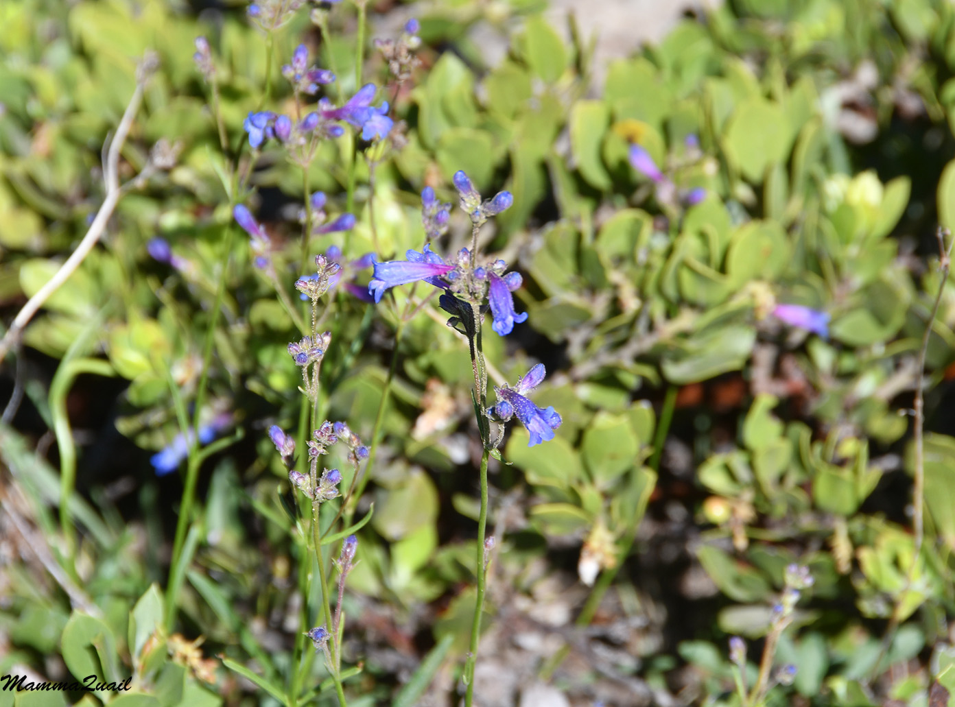 |
| Penstemon |
Just before going down into the woods again I snapped another photo of the Mud Creek Falls. It looked the same as it was two days ago when we hiked up that trail. This time I was saying goodbye.
 |
| Mud Creek Falls |
We were back at the trailhead before I opened too much of a gap behind the others. After depositing the waste in the proper receptacles we split to our vehicles. The fist thing I did after taking my backpack off was to change back to my sandals.
We met back at town of Mt. Shasta where we returned the group equipment, exchanged email addresses and hugs, and said goodbye. It was noon, and the trip was over. All too soon, all very surreal. Now it was anticlimax time.
I originally planned to stay that night in the motel at Mt. Shasta, but now I felt it would be a waste of time. It was very hot outside and the air was already smoky from the nearby nascent Lava Fire and I didn't feel like spending the rest of the day closed inside an air conditioned room. I had lunch in town, then I called the motel's office and told them I won't be staying there that night. Then I turned my car and headed south to Lassen Volcanic National Park. I figured I'll go visit my favorite National Park in California before taking the long drive home.
I wish to express my thanks to the team of REI Adventures for organizing this expedition. I want to give special thanks to the guides of my group, Ethan and Joey, who did above and beyond to give us a wonderful, uplifting experience and ensure our safety while having it. When I return to Mount Shasta I sure hope to join them again.
I also want to add special thanks to Pappa Quail, who supported me from the moment got the idea in my mind, throughout all the training time, and all the way to the end. Thank you, my darling!


