|
Pescadero State Beach, September 24, 2016
|
Dates: July 19, September 9, and 24, October 1, and 8, 2016
Place: Pescadero State Beach, San Gregorio, California
Coordinates: 37.273638, -122.40866
Length: 3 miles
Level: easy
In my humble opinion, the best Bay Area region for fall hiking is the San Francisco Peninsula coast. Last summer I hiked at Pescadero State Beach for the first time, and the following fall I went back there a few more times, alone and with company. The park's trail system isn't extensive - there are only two trails off the beach. Each time I hiked the trail north of Pescadero Creek, first going on the fixed dunes east of Hwy 1, between the lagoons and along the creek, then going under the highway and completing the hike along the beach.
 |
My hike on September 24, 2016, as captured by my GPS. The tide was lower than the map's waterfront ...
|
There is always something blooming along the coast, even in the end of summer. As could be expected, I've seen the most bloom on my first hike there, on July 19, and most of the wildflowers' photos posted here are from that date.
The first flowers I've seen right by the parking lot, where I lingered long enough to appreciate them.
 |
Gumweed, Grindelia hirsutula, July 19, 2016
|
On my following visits to Pescadero State Beach I've seen less and less wildflowers, and more birds, according to the seasons' turn.
 |
Beach Evening Primrose, Camissoniopsis cheiranthifolia, October 1, 2016
|
The trail begins on the east side of Hwy 1, and that road crossing is the most dangerous part of the hike, because the cars come careening at top speed downhill from the north and speeding up after a big curve from the south, and finding a wide enough gap between them for a pedestrian to cross safely could be a challenge, especially on nice weekends.
 |
At the trail's beginning: Century sp., July 19, 2016
|
The first 1/2 mile the trail is narrow and goes through thick vegetation that varies from knee- to neck-height. There is a wide variety of plant species there, many of which are non-native, but there were also many native California plants holding good grounds along the trail.
|
|
Pacific Aster, Symphyotrichum chilense, September 24, 2016
|
Of the non-native species the most prominent grass was the pampas grass, an invasive weed brought from South America for landscaping and took over many areas along the Pacific Coast. It is very pretty, no argue there, but it doesn't belong here.
 |
Pampas Grass, Cortaderia jubata. Invasive, non-native. September 9, 2016
|
Another dominant plant there, and very much a California native, is the coyote brush. And it was in bloom still in the fall.
 |
| Coyote Brush, Baccharis pilularis, September 9, 2016 |
The aster family is always well represented in nearly every place, but their blossom seems to be especially dominant during fall time, when most other plants have already gone to seeds.
 |
| Pearly Everlasting, Anaphalis margaritacea, July 19, 2016 |
Some of the wildflowers bloom pretty close to the ground and required me to stoop low to appreciate them.
 |
California Broomrape, Orobanche californien, July 19, 2016
|
My July hike was very slow not inly because of the many wildflowers I was giving attention too, but mostly because of poison oak that overgrew into the trail. Fortunately the park's authorities cleared most of the path before I returned there in September. Unfortunately I did get in contact with fresh poison oak sap, causing my arms skin to break out in ugly blisters that took over 2 months to heal.
 |
Poison Oak, Toxicodendron diversilobum, September 9, 2016
|
The trail ascends the hill a bit to avoid the wetland and lagoon below. The north lagoon, well seen even from the road, is home for ducks and herons, and looks very pretty when reflecting the bright blue sky.
 |
September 24, 2016
|
One of the common invasive weeds along that path was an old world species of thistle. While some of the thistle was still in bloom, most of them had already spread their seeds, and in abundance. Some of the thistle seeds were trapped on tarweed plants, effectively coating them with their fluffy parachutes.
 |
September 9, 2016
|
The tarweed, as its name suggests, secretes sticky resin from its leaves and stem that is unpleasant to touch and therefore, an effective bug deterrent. Extending over the sticky green parks are the plant's inflorescences that are safe for insects to pollinate (and eat, as the maggot in the photo does).
 |
Grassy Tarweed, Madia gracilis, September 9, 2016
|
On some of my hikes at Pescadero I kept running into spider webs that stretched across the trail. That indicated to me that I was the first one on the trail that day. With apology, I would remove the web, sending the spider running down the threads into the safety of the bushes.
 |
September 9, 2016
|
After about half a mile the trail reached a view point over a second wetland and lagoon area. It was also a very good spot to take a short break and observe the birds below.
 |
July 19, 2016
|
The trail continued west, down from the observation deck and onto a light metal bridge across a wide slough. On the other side of the slough the trail changes its character completely - I was now walking on sand dunes that were bolted down by low and spread sand vegetation. It was tempting to remove my shoes and walk barefoot but I resisted the temptation, saving my feet for later at the beach.
 |
October 1, 2016
|
The most common sand plant there was an invasive weed from South Africa - the ice plant. The widespread ice plant forms almost pure mono cultures in areas where it is established, effectively eliminating local species. I was glad to see that the sand dunes at Pescadero were not completely taken by the ice plant. Perhaps there are removal efforts there.
 |
Wight's Indian Paintbrush, Castilleja wightii, September 9, 2016
|
One of the tougher California native plants that gives a good fight to the ice plant is the coast buckwheat. There were many of them growing on the dunes and they bloomed nicely from July through September.
 |
Coast Buckwheat, Eriogonum latifolium. September 9, 2016
|
Another sand beauty that I've seen blooming from July through September was the coastal bush lupine. It wasn't covered with blossom, just a few flowering branches extending rom the shrub here and there. Most of the reproductive branches of these plants were already bearing pods.
 |
Coastal Bush Lupine, Lupinus arboreus, September 24, 2016
|
Walking in sand can be a slow business. Especially on a beautiful day and many flowers still in bloom. I saw more yellow along the trail in the form of the seaside golden yarrow, another member of the aster family.
 |
Seaside Golden Yarrow, Eriophyllum staechadifolium, July 19, 2016
|
Not looking much like an aster, but still in that family is the beach sagewort, it's tiny blossom peeking through the plant's thick fur.
 |
Beach Sagewort, Artemisia pycnocephala, July 19, 2016
|
Farther down the trail I stopped and looked back at the slough and the metal bridge. Enjoying abundant brackish water the wetland plants looked healthy and green. The red carpet is the invasive ice plant.
 |
July 19, 2016
|
A great blue heron is a permanent resident at that slough and the adjacent wetland where Pappa Quail photographed it on the day he joined my hike there.
 |
October 8, 2016
|
About a mile into the hike there is another bridge over the slough. This bridge is low and made of wood so old that some of my companions expressed some concerns regarding its integrity. It did bear us all, however. On the south side of the bridge the trail split in two ways - one going westward to the main Pescadero Creek lagoon and the other going eastward along Pescadero Creek. Nit wanting to make my hike too short I took the eastern trail to the creek.
Once again the terrain changed and I was walking now on packed dirt and flanked by the dead and dry stems of fennel and thistle. The fennel seeds are very tasty, and while for humans they are a spice, these seeds are a staple to the little bush birds that make their home in this park.
 |
Lesser Goldfinch, females. September 9, 2016
|
A green, and still blooming plant by this part of the trail got me very excited - it was a milkvetch shrub, and later I found that it is also a fairly rare species of milkvetch too. I was very happy to see it bloom.
 |
| Marsh Milkvetch, Astragalus pycnostachyus, September 9, 2016 |
The milkvetch plant also provided a little encounter with a little wildlife -a pretty heteropterous bug, small and brown like a piece of a dead leaf that landed randomly on the milkvetch.
 |
September 9, 2016
|
further down the trail and up the creek there is a single eucalyptus tree, separate from the main eucalyptus forest on the hill, and apparently much, much older. Being alone with no competition for light it doesn't reach high but is low and wide-canopied with thick branches winding horizontally away from the main trunk.
I don't normally think of eucalyptus as good trees for climbing but this individual is just perfect for the job. On those hikes I was with families the children made the best of this lovely natural play structure.
 |
Eucalyptus, July 19, 2016
|
I continued along Pescadero Creek trail until I found an access to the water. There is no convenient beach at that place and the access to the water is jammed with fallen logs and other debris. It is a very nice view point on the creek, nonetheless.
 |
July 19, 2016
|
On my July hike I found the creek level to be quite low. On that day I was there with one companion only, and we were quiet enough no to scare away the doe that was exploring the exposed creek bed. She did eventually notice us and walked elegantly away into the bank's vegetation.
 |
Black-tailed Deer, July 19, 2016
|
The trail continues a little further east beyond the water access point, and on two of my hikes (the first and the last) I followed it to the end to see what I could find.
Going on that trail segment in July was somewhat challenging because the trail was overgrown with vegetation. Willows mostly, but many other things as well. Luckily not that much poison oak.
 |
July 19, 2016
|
One of the interesting plants I saw on that trail segment was the sneezeweed with its weird, button-looking inflorescence.
 |
Sneezeweed, Helenium pberulum, July 19, 2016
|
I didn't bring the groups I hiked with later on that trail segment, except for the 4H Hiking Project on my last hike there on October 8. The trail looked very different then - all cleared and easy to walk on. There was no bloom there that time, and only dry foliage left of the sneezeweed plants.
 |
October 8, 2016
|
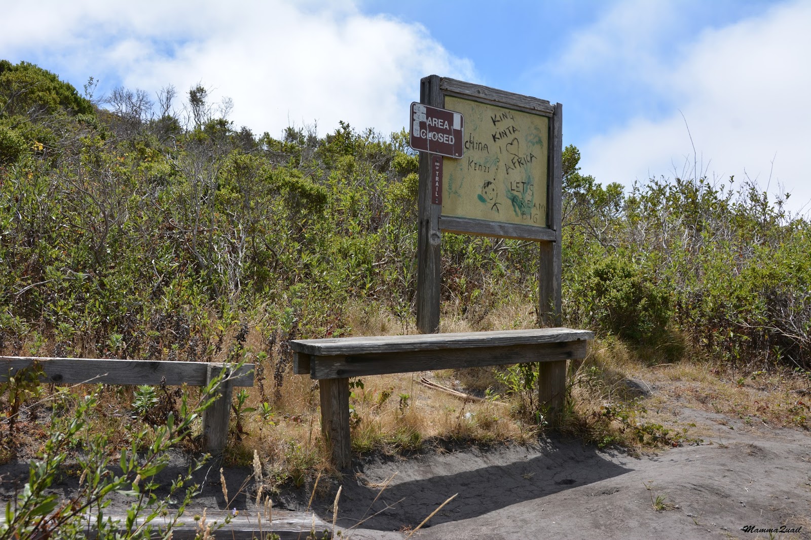
The trail continues a few more yards up the hill and then comes to an abrupt stop with a sign that shows graffiti only and a broken bench. Ahead there is a thick chaparral and no open view.
 |
July 19, 2016
|
Turning to face back north, however, there is a wonderful view from that point on the wetlands below and the eucalyptus forest flanking on the east.
 |
July 19, 2016
|
Any encounter with wild animals on the trail is an excitement. Particularly animals that are shy and avoid people as a rule. There is always a better chance of seeing wildlife when hiking alone or in company that is small and quiet.
 |
Cottontail Rabbit, July 19, 2016
|
Later in the fall I had the chance to see the alkali heath in bloom. Not much, but delicate and pretty. This plant does well in high salinity lands and is common in California salt marshes.
 |
| Alkali Heath, Frankenia salina, October 1, 2016 |
I was making my way back to the cross trails. Lizards like to sun on the open trail and by my last hikes I were expecting to see them there. they would wait for me to approach, then dart quickly to cover, posing for a moment by the edge of the vegetation and turning back to look at me.
 |
Side-bloched Lizard, September 9, 2016
|
When I reached the cross trails again I turned left to the big lagoon maid by Pescadero Creek. This lagoon is formed by a sand bar that blocks the creek from flowing above ground all the way to the ocean. Most of the time. The bridge across the creek is that of Hwy 1.
 |
Pescadero Lagoon, July 19, 2016
|
The shore of the lagoon was strewn with driftwood, of which park visitors have used to built shacks, rafts, and all kinds of weird structures, at least some of which were built by youngsters attending a summer camp there in July. In between and behind the driftwood there grew a belt of beach grass that I did not identify.
 |
September 9, 2016
|
Hidden between the grass bunches were low cushions of beach bur - its delicate inflorescences hanging shyly like fairy chandeliers.
 |
Beach Bur, Ambrosia chamissonis, July 19, 2016
|
Large pieces of driftwood were anchored in the lagoon itself and their protruding bare branches were a perfect seat for cormorants.
 |
Double-crested Cormorant taking off, September 9, 2016
|
On my July hike with my friend we continued a bit up the creek right along the wait line, and around the creek bend we saw a sandbar occupied by a cotillion of caspian terns.
 |
Caspian Tern, July 19, 2016
|
We didn't approach very close but the terns took to the air nonetheless.
 |
Caspian Tern, July 19, 2016
|
We turned about and returned to the lagoon.
The Pescadero Lagoon was the perfect location to stop with the family hiking groups because there the children (and adults) could get into the water in safety. Exploring the beach as only children can, they came upon a sole sand hopper that had strayed to far from the source of moisture.
 |
October 1, 2016
|
One of the parents in that group called my attention to the circular ripples diffracting around a small piece of driftwood - a pleasing sight to any physics lover.
 |
October 1, 2016
|
Quite a few birds had claimed this lagoon as their haunting grounds. There were cormorants, mergansers and ducks. I was happy to see serf scotters there too.
 |
Surf Scoter, male. July 19, 2016
|
As summer turned into fall I could see more and more birds in the lagoon and on the beach. Papa Quail had joined my last hike there with the Redwood 4H Hiking Project, and he was putting his high zoom camera into an excellent use.
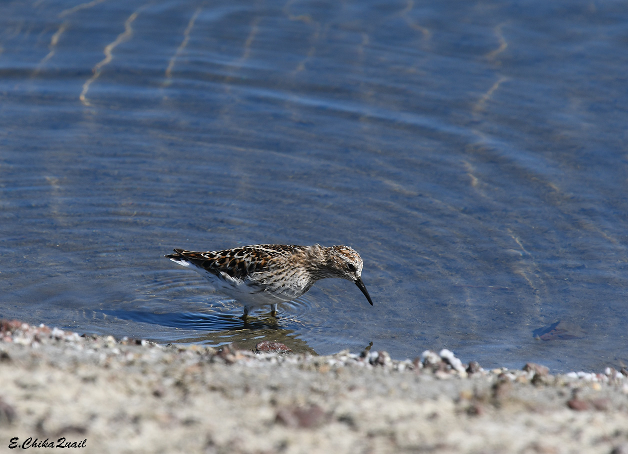
 |
Least Sandpiper, October 8, 2016
|
From the lagoon we were making a slow progress (it was hard to leave the place!) towards the ocean, passing underneath the bridge. The sandpipers and other shorebirds that were pecking at the mud would fly a short distance, then settle themselves back onto the sand, pecking enthusiastically in the shallow water.
 |
Killdeer, October 8, 2016
|
A low ridge or rock cliffs stretches along the south band of the Pescadero Creek and a pretty little arch at the cliff's edge makes a nice window through which the waves show, and often flow through. On my first hike there the creek flowed directly into the ocean. The stream was very shallow but I was already tight in time so I remained on the north bank and didn't go near to the arch.
 |
| July 19, 2016 |
On all my other hikes there the sandbar had effectively blocked the creek flow and I could walk right up to the arch. It is tall just enough for the children to stand there upright. They did, however, run back quickly when the waves lapped at their feet through the rocky passage.
 |
September 9, 2016
|
It's a short stretch of beach from the mouth of Pescadero Creek to the north parking lot, but walking this short distance took almost as much time as the the hiking trail. There was the ocean, of course, and the amazing buffet of wonders it offers to nature-loving visitors.
 |
October 1, 2016
|
The off-shore rocks near the arch were full of shore birds, and Pappa Quail lingered there for quite a while. The most common of those shorebirds were the black turnstone, and they were the least disturbed by the close proximity of humans.
 |
| Black Turnstone |
Near the black turnstone were its close relatives the ruddy turnstone, searching and digging in the mud.
 |
| Ruddy Turnstone |
I have seen the black turnstone on each of my visits there. On my first visit, however, I also photographed another bird on that rock, that Pappa Quail had later identified as a wandering tattler - a pretty nifty sighting. The wandering tattler was no longer there when Pappa Quail came along.
 |
Wandering Tattler, July 19, 2016
|
A mat of sleeping harbor seals covered one of the farther off shore rocks. Twice I could also see seal heads bobbing up and down with the waves.
 |
Harbor Seals, October 8, 2016
|
The most common birds on the beach were gulls. Specifically Heermann's and western gulls. The Heermann's gulls were busy digging the mud like any sanderling.
 |
September 9, 2016
|
The gulls also weren't concerned much with the people walking up and down the beach, but the much more skittish terns took to the air right away, and the gulls that were near them got excited too and joined them (header photo).
 |
Heermann's Gull, October 8, 2016
|
The western gulls were interested in slightly bigger morsels. Many broken shells of large dungeness crabs littered the beach and we've seen the western gulls feeding on some.
 |
Western Gull, July 19, 2016
|
And for the first time I've seen one of these crabs alive and out in the open. It did dig itself into the sand very quickly as we approached to look at it.
 |
Dungeness Crab, October 8, 2016
|
Stranded kelp is a common fall time sight on California beaches, and Pescadero Beach had all of their species represented on the sand.
 |
| Sea Palm Kelp, September 9, 2016 |
Little sanderlings running in and out of the ocean's strand line is a common sight on many a California beach, and it never ceases to amuse and mesmerize me. These small shorebirds are perfectly coordinated with the waves and with each other. I could watch them run with the waves for a very long time. They are very pretty too.
 |
| Sanderling, September 9, 2016 |
All along the beach there were these funny driftwood structures. Some were quite elaborate. I've seen people camping inside some of them, and some of my companions have explored inside these structures. Not trusting the integrity of these, I dared not go in any of them.
 |
| September 9, 2016 |
All good things must come to an end, and as slow as the beach walk was, eventually we got back to the parking lot. When I found the tie after the hike I would bring my lunch out and have a slow picnic on the sand, staring at the breaking waves until my mind was cleared and my spirit was calm.
 |
September 9, 2016
|