Showing posts with label Sacramento River. Show all posts

Monday, January 31, 2022

A Refreshing Hike at the Castle Crags River Trail

The Sacramento River


Date: June 27, 2020
Place: Castle Crags State Park
Coordinates: 41.149827, -122.307357
Length: 3.1 miles
Level: easy


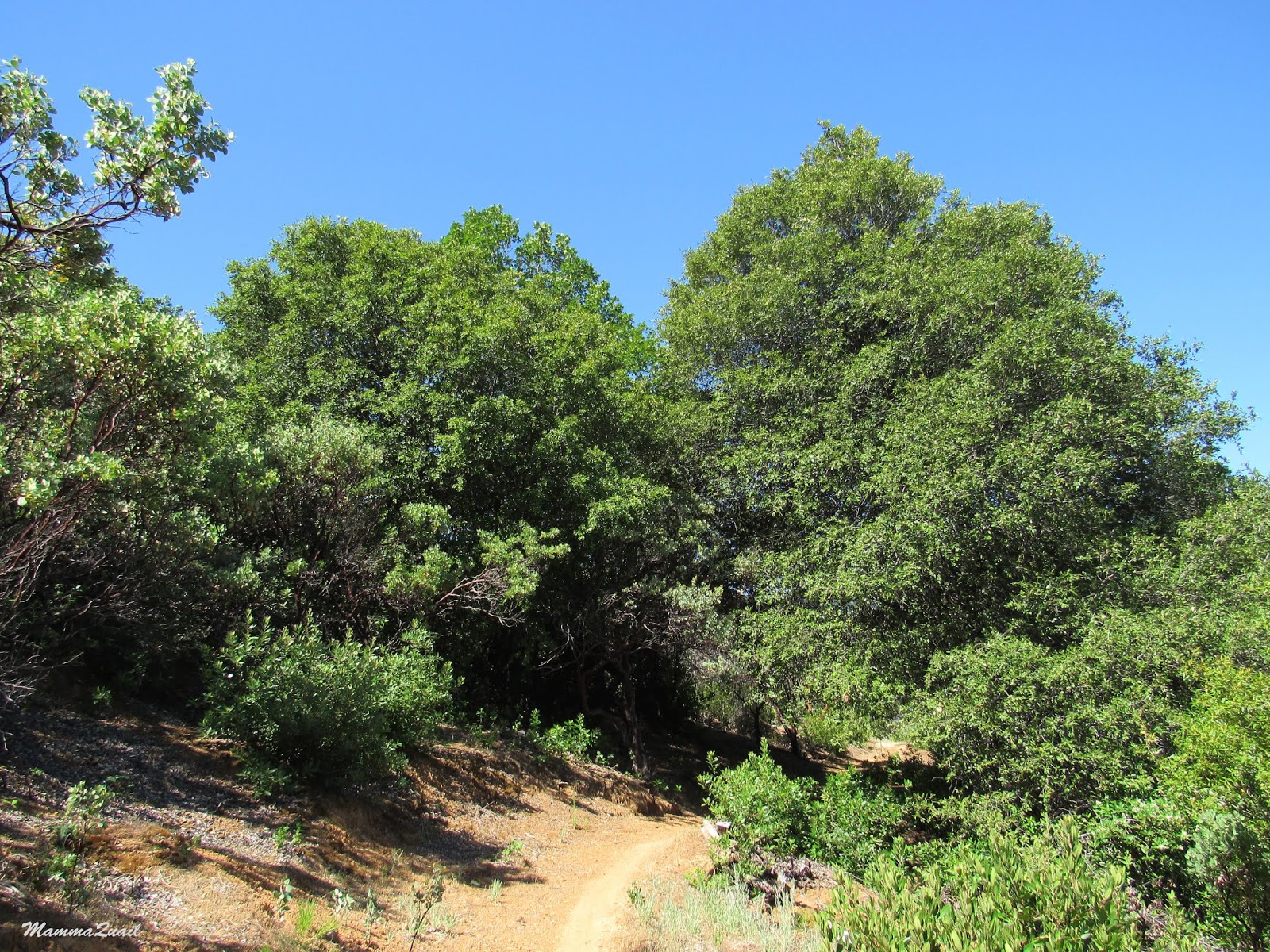
All of our plans for the summer break of 2020 were shattered by COVID. The chikas were in distance earning since March and at the beginning of the summer break we still didn't know if they'll be going back to school in the fall (they didn't). Those 'two weeks until the curve is flattened' were extended, seemingly forever. Thankfully we remained physically healthy, but we seriously needed a break from the choking environment of the Bay Area. The rural areas of California and the neighboring states were much less restricted, and we chose to go on a week long road trip to Bend, Oregon. We drove north on I-5 and stopped for an afternoon hike at Castle Crags State Park, near Mount Shasta. 
We've hiked numerous times in Castle Crags State Park, but always as a break on the way from one place to another. And I never wrote about any of our hikes there before. There is a lot to see there, and one day I'll make it a sole destination to explore. 
The River Trail seems separate from the rest of the park not only by the freeway, but also because it's not in the crags area. It's an easy walk along the north fork of the Sacramento River, which makes it a great little hike to break a long drive with. 
Our hike as captured by my GPS 

Right away, just at the beginning of the hike, I saw white lilies blooming. I've never seen those in the wild and at first I thought these were cultivated lilies that escaped to the wild. This lily is however, a native California species.  
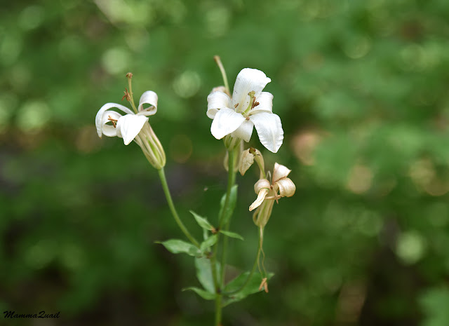
Washington Lily, Lilium washingtonianum

The trail follows the river fairly closely most of the way. Most of the way it is also impossible to see the river because of the thick vegetation.  

The chikas found a short millipede on the trail and call me excitedly to take a photo. The little guy was making its way across the path, getting away from us as fast as it could. 

We assumed our usual waling order in which Pappa Quail and the elder chika are in the lead, followed by the younger chika, and me bringing up the rear. I like to stop whenever I see wildflowers or other interesting sights.  
California Harebell, Asyneuma prenanthoides

The chikas wanted to get to the water. When we saw the river for the first time on the trail it was below us and there was no easy access down. On the map it looked like there would be suitable places further ahead. I hoped that would turn out to be true. 
The Sacramento River

There were many spider webs along the trail. I admire these little weaved wonders and the creatures that make them. 

I was surprised to see how many people were using that trail. It wasn't very crowded but there was certainly a good number of humans present. Most of them however, weren't exactly hiking. Many of them were dressed beach attire and were carrying floaters and coolers. I took it as a reassurance that there would be river access further on that trail. 
None of the other trail users seem to notice the little orchids that bloomed in the wetter parts of the trail. 

The bleeding heart is common enough in the Northern California forested areas but I always love to see it on my hikes. Its pink, drooping flowers don't remind me of a heart shape, and they certainly don't look 'bleeding' to me, but my opinion wasn't taken into account when naming this plant.  
Bleeding Heart, Dicentra formosa 

I caught up with Pappa Quail and the chika when they stopped to photograph a lizard that was sunning itself near the trail. The lizard seemed cooperative enough so I photographed it too. 
Alligator Lizard 

We kept looking for a river access but the trail was still to high above the water with much vegetation in between. At some point we had to take a short detour around a side tributary.

Back near the river, more wildflowers were painting our way, such as the impressive-looking tiger lily. It doesn't show it in the photograph, but these lilies are tall plants, almost adult human size. Their bright orange flowers are visible from a long distance away.
California Tiger Lily, Lilium pardalinum

Another prominent color along that trail was added by the sweet pea - a very aggressive invasive plant, that has taken over wide areas in Northern California.
Sweet Pea, Lathyrus odoratus. Non-native, invasive

At last we found access to the river. As I had expected, the place was already occupied by many other humans. The water looked too turbulent as well. We decided to continue on, and I promised the chikas that we could stop here on the way back if we won't find a better spot.
The Sacramento River
 
I caught up with Pappa Quail while he was photographing a little Pacific wren. These birds are common enough, but are hard to see, let alone photograph. It's easier to hear them for they have a lovely, distinct song.
Pacific Wren

I don't know if the empty nest that Pappa Quail had found later was a wren's nest. I hope that whichever bird it belonged to was successful in rearing its fledglings to take flight.

Nest

My attention went back to the trail and the wildflowers that bloomed along side. 

We were getting near the end of the trail. On our way we saw a few more river access places, but all of them were already occupied. I was just fine to continue walking but I knew we had to appease the chikas with some river time. meanwhile I tried to keep them excited with the botanical wonders we saw along the way.
Wood Rose, Rosa gymnocarpa 

The trail ends with a Private Property sign. We had reached the park's northeastern boundary. Turning around we found the nearest place with river access and went down to sit by the water and have snacks. The water looked inviting and the chikas took their shoes off and waded a bit near the shore. Pappa Quail and I sat in the shade of a tree and watched the water flow by us. It was a hot day and a nice, quiet afternoon. We still had some drive ahead of us - we planned to reach Klamath Falls by night.
Sacramento River

When I got tired of sitting I did a little exploration of my own in the bushes and came upon this insect of a kind I've never seen before. I kept looking for them on the way back and found a few more. I still don't know what they are.

After a nice break by the river Pappa quail reminded us that we needed to get back to the car. On the way back we saw more people yet making their way to the river stops. The trail was turning more populous than I was comfortable with at the time. It was time to get back.
The Sacramento River

The River Trail is an in-and-out trail. We backtracked, walking quickly, hardly stopping for anything on the way. The chikas started talking about dinner (which we planned to have in the town of Mt. Shasta). The shadows were getting longer but the day was still hot.


 I've hiked numerous times in Castle Crags State Park, yet this trail is the first I write about, and it is the least characteristic of this park's hikes. It is a fitting one to start with though, since each time we've been in that park it was on the way to some other place. Hopefully the next time I go there it'll be to stay and explore it as it deserving.


Thursday, March 19, 2020

Exploration on Foot at Turtle Bay, Redding

Sacramento River View East from the Redding Sundial Bridge

Date: November 27, 2019
Place: Turtle Bay, Redding, California
Address: 844 Sundial Bridge, Redding, CA 96003
Length: 3 miles
Level: easy

Last Thanksgiving week the chikas' schools were out for the entire week. Pappa Quail however, was still working until Thanksgiving Day, so I took the chikas and their friend for a three-days trip to the Shasta area for some exploration and fun. During the first days there we had visited the Shasta Dam and explored Pluto's Cave. On the last day, before heading back home, we went to the famous Turtle Bay Exploration Park. After visiting the museum and the animals area we went over the Sundial Bridge across the Sacramento River for a hike in the little river preserve and the McConnell Arboretum & Gardens.
Our hike as captured by my GPS
The days we spend in the Shasta area were also when the first winter storm had stormed through Northern California, bringing well needed rains but also dumping lots of snow even on lower elevations that do not often get snow.
When we were at Turtle Bay the main storm was already over but it was still overcast with heavy clouds, and it was still cold with an occasional rain shower. 
The sky looked very dramatic indeed and all of us bundled well for the hike.
Crossing the Sundial Bridge
There were a few people out and about. I assume that on warmer days the place there are more people there but on that day we had the bridge almost entirely to ourselves.
I stopped in the middle of the bridge and looked at the Sacramento River. The river was full and flowing high and fast. It certainly wasn't a day to go swimming in the river.
At Turtle Bay the Sacramento River has a coupler of wide curves so at the place of the Sundial Bridge the river flows from west to east rather than north to south as is most of its path. A mountain loomed over the western river bend. The kids wondered if that might be Mt. Shasta but the proximity to Redding and moreover - the wrong direction, ruled that right out. But I couldn't tell them then what was that mountain. 
Sacramento River View west from the Redding Sundial Bridge
Needless to say, without the sunlight, the sundial function of the bridge's tower was of very little use for telling time. We did enjoy going under it and around it and posing for some photos with it in the background. 
Under the Sundial Bridge
Satisfied with the close up view of the Sundial Bridge tower we took off eastward on the Sacramento River Trail. Large valley oaks loomed over the trail, adding whatever shade left of their fall-dwindled canopies to that of the rain clouds.
Valley Oak, Quercus lobata 
The trail near the river attracted joggers, dog walkers, and fellow hikers. Once we turned north to follow the loop there were fewer people along the trail.
To the east rose a low hill with houses at the top. To the west spread a flat oak savannah that before the building of the Shasta Dam, as we learned on or visit there two days before, used to be seasonal flood plains that became submerged whenever the river got engorged by the winter storms or fast snow-melt events.
The mountain we've seen from the bridge was visible over the trees, its summit hidden in the clouds. Once again the kids asked about it, and once again I shrugged. I didn't know the name of that peak, but I did know it wasn't Mt. Shasta.

The trail was paved all the way through, making it an easy, fast walk for us. We kept going round the loop and, looking south, we could see the tilted Sundial Bridge tower poking through the oaks.
The sky looked dramatic but no rain came down.

Suddenly - sunshine! The sun found its way through a hole in the clouds and gave us a brief warm moment. A moment to enjoy the scenery in its fall beauty.
Valley Oak, Quercus lobata
There were no flowers to be seen anywhere. It was too late in fall and too early in winter fr that. All the grasses were dry and many of the undergrowth shrubs were bare. I thought some of them looked familiar and when I saw some bearing fruit I recognized them immediately - even without the 'leaves if three', these were poison oak.
Poison Oak, Toxicodendron diversilobum
And a good thing it was that I recognized it on time because my younger chika was just about to pick up a fallen twig from under one of these irritant bushes. I stopped her right as she was reaching for it.
Poison Oak, Toxicodendron diversilobum
We kept going around the prairie, now enjoying intermittent sunny patches. On a different season I might have taken more time to explore the area but there were no wildflowers and we saw no wildlife save for a few little bush birds.

The western arch of the loop trail was lined with different bushes - cultivated roses, also in their fruit-bearing phase. I reached for the fruit, and they were soft and supple, so I picked some and ate them. The kids saw me and followed suit, making faces at the many seeds and hairy texture.
Rosehips 
Under the rose bush, hidden from the weak sunshine, were the remains of yesterday's snow. Redding is too low and warm to get snow frequently, and although a good amount came down, very little of it remained by the afternoon of the following day.

By the time we were completing the loop trail the sun hid behind the clouds again.
Back on the Sacramento River Trail
 Knowing the kids I thought they would want to finish the hike right there but to my surprise they decided to go on and explore the McConnell Arboretum & Gardens. Needs to say, I was all for it.
Little redbud trees in fall colors welcomed us as we entered the arboretum.
Western Redbud, Cercis occidentalis 
I spotted a pretty monument in the shape of a crab's pincer, picturing many local animals down the trail, so we went down that path to get a closer look.

Near the monument I spotted the only plant that was blooming that day n the arboretum - a California fuchsia, low near the ground. It made me happy to see the flowers.
California Fuchsia, Epilobium canum
At the west end of the arboretum there is a small human-made island which is a mound of rocks and soil, still being planted and landscaped. It is the "Spider Island" and the bridge leading to it is decorated with metal spiders and is appropriately named, "Charlotte's Bridge". Not a place for arachnophobic people, I guess, but I found it amusing. We didn't see any real spiders there that day, however.
Charlotte? 
What we did find here (actually, it was my elder chika who found it), was a little tree frog hopping by the trail. I managed to get a ew shots before it vanished out of our sight.
California Tree Frog
We were circling the island and the afternoon sun graced us with another rare appearance, revealing the pretty fall colors of the bushes by the trail side.

As we were rounding our loop around the island we were also going around a small pond full of ducks. These were mostly mallards, my elder chika informed me.

We came around the pond, enjoying a nice reflection o the fall-colored trees behind it. The arboretum's nursery was behind it too. Any other time I might have been tempted to go inside and look for plants to buy but this was not the time for it.

The clouds closed on us again, eliminating whatever little warmth the sun had blessed us with. Moreover - the afternoon wind picked up. We wrapped ourselves again, and hurried out of the arboretum. As we crossed the river again back to the Turtle Bay Exploration Park's parking lot I stopped once more in the middle of the Sundial Bridge and took a close up shot of the mountain to the west.
Today, as I am working on this blogpost, I took the time to post the mountain photo online and soon enough I had an answer for my query: this mountain is called Shasta Bally and it is part of the Whiskeytown National Recreation Area. I know now where I plan to hike next time I'm near Redding.
Shasta Bally 
This nice hike was our last activity in the Shasta-Redding area. After a nice lunch in town, we took off on the long drive back to the Bay Area. The day after we would go out again, this time without the chika's friend but with Pappa Quail, once again to Northern California, but this time along the coast: to Redwood Country. 


Sunday, January 20, 2019

Hiking Down the Ditch: Down Digger Creek to the Sacramento River


Sacramento River

Date: June 10, 2018
Place: Shasta Dam, Lake Shasta National Recreation Area, California
Coordinates: 40.712570, -122.415922
Length: about 5 miles (from the dam trailhead to Chamise Peak trailhead)
Level: moderate to strenuous

A century and a half ago prospectors came looking for gold in the mountains near where today is the city of Redding. The river was down below and fetching water a hard work so they dug a ditch to bring water from the high sources to the little mining settlements along the river. In the modern days this ditch was converted to a lovely hiking/biking trail that stretches from the Shasta Dam all the way down to Redding.
Last June I was planned to take my family hiking group on a camping trip in the area and the Ditch Trail was high on my list of hikes to take them on so some days earlier I went there to go on a solo prep hike.
The blooming toyon welcomed me as I started down the trail.
Toyon, Heteromeles arbutifolia
It was a hot day and I liked the shaded trail I was walking on. It was level at first, but then plunged into a few down-sloping switchbacks.

Alongside the trail bloomed the Saint John's Wart in large numbers. Not the native species, however, but an invasive European one.
Klamathweed, Hypericum perforatum
When u visited the area in April with my family the redbud trees were in full bloom and no foliage. Two months later they all had their large, butterfly-shaped leaves, with clusters if red seed pods dangling from their thin branches.
Western Redbud, Cercis occidentalis
The redbud can be quite spectacular when blooming and very pretty still when laden with fruit but as far as blooming shrubs go, the mock orange was the favorite of my hike there. Its delicate white flowers reminded me of fresh snow flakes - a cool relief in an otherwise very hot day. I came across this species several times during the hike.
Wild Mock Orange, Philadelphus lewisii
For the first mile I defended through forest of low-canopy trees. I was glad of the shade because the day was hot and getting hotter yet. Most of the bloom I saw along the trail was that of shrubs and bushes. There were some interesting plants blooming there that I don't get to see very often.
Snapdragon Skullcap, Scutellaria antirrhinoides
But the one blossom that made me the happiest was that of the spicebush. A month earlier it was in its beginning, but come June, it was in its full glory.
Spicebush, Calycanthus occidentalis 
While attracted many to flowers I certainly don't ignore other plant beauty, like the cluster of maple fruits like green, balled-up hedgehog.
Vine Maple, Acer circinatum
Eventually the trail leveled off and I was out of the woods. I was still pretty high above the Sacramento River and the vegetation changed to chaparral. I walked under thick power lines that stretched from the valley below all the way up and over the hill.

I followed the powerless with my gaze - they originated at the hydroelectric power plant of the Shasta Dam.  I had now full view of the dam, a massive wall of cement and very impressive piece of engineering holding the huge Shasta Lake behind it, loomed over the valley.
Shasta Dam
I admired the dam for a few moments, then moved on with my hike. The trail curved southward and remained level and high above the river. Every now and then the chaparral changed into patches of low forest, especially when crossing the little creeks that were running down the hill into the valley below.

Manzanita bushes were dominant of the hillside. I love the sight of the old red bark peeling off to reveal the fresh green one. Very delicate.
Manzanita
At one of the little creek crossings I passed along my way I saw a large oleander bush. I know this plant very well from the old world - very beautiful but deadly when consumed, even in minute quantities. Despite its toxicity oleander is used in landscaping and sometimes it escapes to the wild. In California it is, of course, an invasive species.
Oleander, Nerium oleander
Of the California native wildflowers I was happy to see (and smell) the coyote mint, a flower I've seen in diverse places throughout this state.
Coyote Mint, Monardella villosa
Wherever there are flowers there would be butterflies. Not as many as I've seen in the area in May but still very present and very beautiful. Most were also too active to pose for a photo.
Pipevine Swallowtail, Battus philenor
Without Pappa Quail around I ay a little less attention to the birds. Some birds, however, are impossible to ignore.
Osprey
The trail stretched on and on high above the river. At no point did it seem that it would go down any closer to the water. I also couldn't see the trail going uphill that I was looking for. It was much farther off than I had calculated form the general map of the area that I got at the dam's visitor center. It was already clear to me that if I'd take the family hiking group down the trail I wouldn't take them that far. I was enjoying the hike immensely, but I also begun worrying about the time it was consuming - I had hoped to check out Caste Crags State Park too that day. 
The Ditch Trail
I tried going faster but found myself stopping again and again to look closely at pretty flowers and other things I encountered on the trail. Some of these wildflowers I don't get to see very often.
Whitestem frasera, Frasera albicualis

And orchids are always a reason for celebration, although the one I saw was broken at the top. 
Flat-spurred Piperia, Platanthera transversa
Between the manzanita bushes I got glimpses of the Sacramento river down below, gleaming in emerald. Occasionally the tranquil water would get disturbed by a speedboat zooming by, and a few seconds after the boat would pass the water would resume its lazy course downstream. 


The water level wasn't high although water is let out pf the dam. I wished I had the time to go down to the river and maybe kayak there a bit. I made a mental note to do that when an opportunity presents itself. 
Sacramento River
I reached the trail fork going up to Chamise Peak and started ascending, going higher and further from the river. Looking back it appeared now as a thick emerald ribbon cutting between the hills. A line of life for the area, indeed for a big part of Northern California. 

Sacramento River
A few bikers passed me when I was following the Ditch Trail along the river. As I started ascending the Chamise Peak trail they came back, rolling downhill. One of them lost control and spilled on the rocks. He wasn't injured badly but had some nasty looking cuts and scrapes on his legs. I proposed to run up to the peak and phone for help but he was able to get up and go on biking with his friends. I walked on.
Chamise Peak Trail
Higher above the river the chaparral got much lower and par less a thicket. There were also much less manzanita and toyon and more yerba santa and other shrubs I didn't identify.

When I made it to the pass I had a surprise - a wonderful view of my favorite mountain in California - Lassen Peak. 
Lassen Peak viewed from Chamise Peak Trail
A half a mile long trail leading to Chamise Peak forked off the main trail. I sat down for a short break and debated with myself wether I had the time to go up the peak. Looking at the time I decided to leave that for another time. I got to my feet and started downhill on the eastern side of Chamise Peak trail. 

It was about a mile more to get to the road. I walked that mile very quickly, stopping only to admire a penstemon that closed near the trail and to have a little chat with a hiker that was taking her daughters to the peak.  
Penstemon sp. 
On one of the trees nearby perched a turkey vulture and looked at me hungrily. I assured it I wasn't about to die soon, andthanked it for posing. 
Turkey Vulture
I reached the road. There were about three miles between the Chamise Peak Trailhead and the Shasta Dam where I was parked. I relied on hitch-hiking that distance but unlike other times in the past when I was picked up almost as soon as I raised my thumb, no one was in a hurry to give me a lift now. So i walked. I walked nearly three quarters of the distance until an old car with a young couple, a toddler and a dog stopped and offered me a ride. I was already very hot and sweaty, and very much behind schedule, and very much grateful for the lift.  
Shasta Lake
As late as I was, I did take the time to eat at the beautiful picnic area by the dam and admire the view of Mount Shasta under the clouds.
Mount Shasta
I then took a short walk on the Shasta Dam itself before driving off to Castle Crags. A few days after I was back there with my hiking group. We hiked down to the dam view point below, then back up to walk across the dam and peer down. It was a short and sweet hike, nearly all shaded which was good, because temperatures reached the 90's that day. There's much more to see and explore in the area and I left eager to go back there. 

Shasta Dam
A few weeks after my hike near Shasta Dam broke the huge Carr Fire which devastated the entire area of Whiskeytown National Recreation Area and reached to Redding, laying waste the neighborhood through which I walked while trying to hitchhike from the Chamise Peak trailhead. Such devastation. Such a heartbreak.