Friday, January 11, 2013

A most elegant rock garden - the Cactus Loop Trail

Date: December 25, 2012
Place: Anza Borrego State Park, Borrego Springs, California
Coordinates: 33.13867, -116.37523
Length: about 1 mile
Difficulty: moderate

On Christmas morning we made and early start in the direction of Borrego Springs, coming from the Julian. Just past the left turn onto Yaqui Pass road, across from the Tamarisk campground, we made a stop. On the map we got a day before at the visitor center there was a little loop trail there, marked: Cactus Loop Trail. We thought it would be a good hike to begin the day with.
A field of cacti
And it was. The Cactus Loop Trail is an interpretive trail, with labeled stops along the way. I picked up a pamphlet at the trailhead and stopped to read the description at every number post.
The pamphlet had names and some information about the plants there. Mostly cacti, but not just.

The pale brittlebush provides the perfect background for the red Barrel Cactus. The grey color of the leaves come from their thick 'fur' coating of fine trichome hairs. These protect the plant from excess radiation and from water loss.
Barrel cactus
When people think 'cactus' they often imagine something that looks either like the giant saguaro (non of them there) or like the Beavertail Cactus - with the flat pads extending from one-another. These pads are stems, not leaves. The leaves of this and other cacti have evolved to be the thorns - the cactus protection against herbivores.  
Beavertail cactus
When it comes to thorns, the title goes to the Cholla cactus, which is very common in Anza Borrego. Its thorn cover is so thick one can barely see the stem underneath. It also tends to break upon contact, thus leaving its nasty thorns inside the flesh. A tackle with one of these isn't a nice experience, to say the least.
Golden Cholla
Nasty thorns alright, but when it comes to blossom, cacti flowers are amongst the most delicate and colorful in the plant kingdom. We were there in December so we didn't get to see any cacti in bloom. These yellow buttresses are the leftover pedicels of the Cholla blossom.

Another iconic plant of the southwestern deserts is the Agave. The green, succulent rosettes were all over the hillside.
Agave
Agave inflorescence
The Agave can grow for decades long, sprouting new plants from its root crowns. When reaching a certain age and size it blooms. Once. Then dies.


Another non-cactus typical to that region is the Ocotillo bush. Its bare branches extend upward, giving the entire plant the appearance of 'The burning bush'. At spring time, these Ocotillo will bear flame-red flowers at the tips of their branches.
No December flowers for us, though.

Ocotillo

The trail goes up quite a bit - on the side of a little desert wash. Being the part where most of the rare rain water collects, the wash bed is also the area most dense with vegetation.


Without their blossoms, desert plants blend in with their rocky environment. From far, many of them appear to be rocks to the scanning eye. It takes a close look to see the richness of plant life in the area that seemed to be barren at first glance.


In spring time, following a good wet winter, these brown hills would be aflame with bloom.

Buckhorn Cholla
Many people turn their yards into rock gardens for the sheer beauty of this landscape. Hiking the hills in Anza Borrego is taking a tour in Nature's great yard's rock garden. I was duly impressed.


We completed the loop and right next to our car a bird was standing on top of a bush. We all got excited - it was our first good sighting of this bird - a male Phainopepla. It sat there patiently, allowing Papa Quail to photograph him from every possible direction.
It is, in fact, a very common bird in those parts, but that was our first meeting with it.
Phainopepla, male

On post # 6 of the interpretive trail, there is a blurb about Bighorn sheep and their adaptation to the desert environment. The pamphlet suggested to look around for possible sightings. After missing them the day before, you can bet I did look for them all along the trail. The sheep, however, didn't show up. 

Tuesday, January 8, 2013

The phantom sheep of Borrego Palm Canyon

Dates: December 24 and 26, 2012
Place: Borrego Palm Canyon, Anza Borrego State Park, Borrego Springs, California
Coordinates: 33.26905, -116.41842
Length - about 2.5 miles round trip.
Difficulty: main trail - easy. Alternative trail - moderate.

A two-weeks long winter break from school gave us a great opportunity to travel to an area of California we've never been to before - the deserts of southern California. For 10 intensive days we hiked trails in Anza Borrego State Park, Salton Sea, San Jacinto and Santa Rosa National Monument and other preserves in that region. We saw great views, met interesting wild animals and plants, many of which where new to us, and took many photographs. We even made new friends in the most unexpected of places!
We returned home exhausted, but resolved to go back and explore more of California's wonderful deserts.

A double rainbow on the road from Julian to Anza Borrego

Our first destination was Anza Borrego State Park. We arrived there on the morning of December 24, and chanced to enter the park's visitor center just as they were about to show a 20 minute documentary about the park. I was eager to start hiking but the chikas along with Papa Quail were inside the auditorium before I could say 'Jack rabbit', so I went inside and sat to watch too.
It was there that we learned that Anza Borrego is the home of 2/3 of the population of bighorn sheep in California, and that it was on the Borrego Palm Canyon trail - just outside the visitor center - where most sightings occur. Naturally, this trail was to be our first hike. The trailhead is actually in the nearby campground. We parked in the day-use lot and headed into the canyon. 
 The mouth of Borrego Palm Canyon
It was almost immediately that we spotted the most exciting bird of the Southwest - the much celebrated roadrunner.

Roadrunner on a rock
It didn't run, just walked here and there, not bothered by anything or anyone, looking for food.
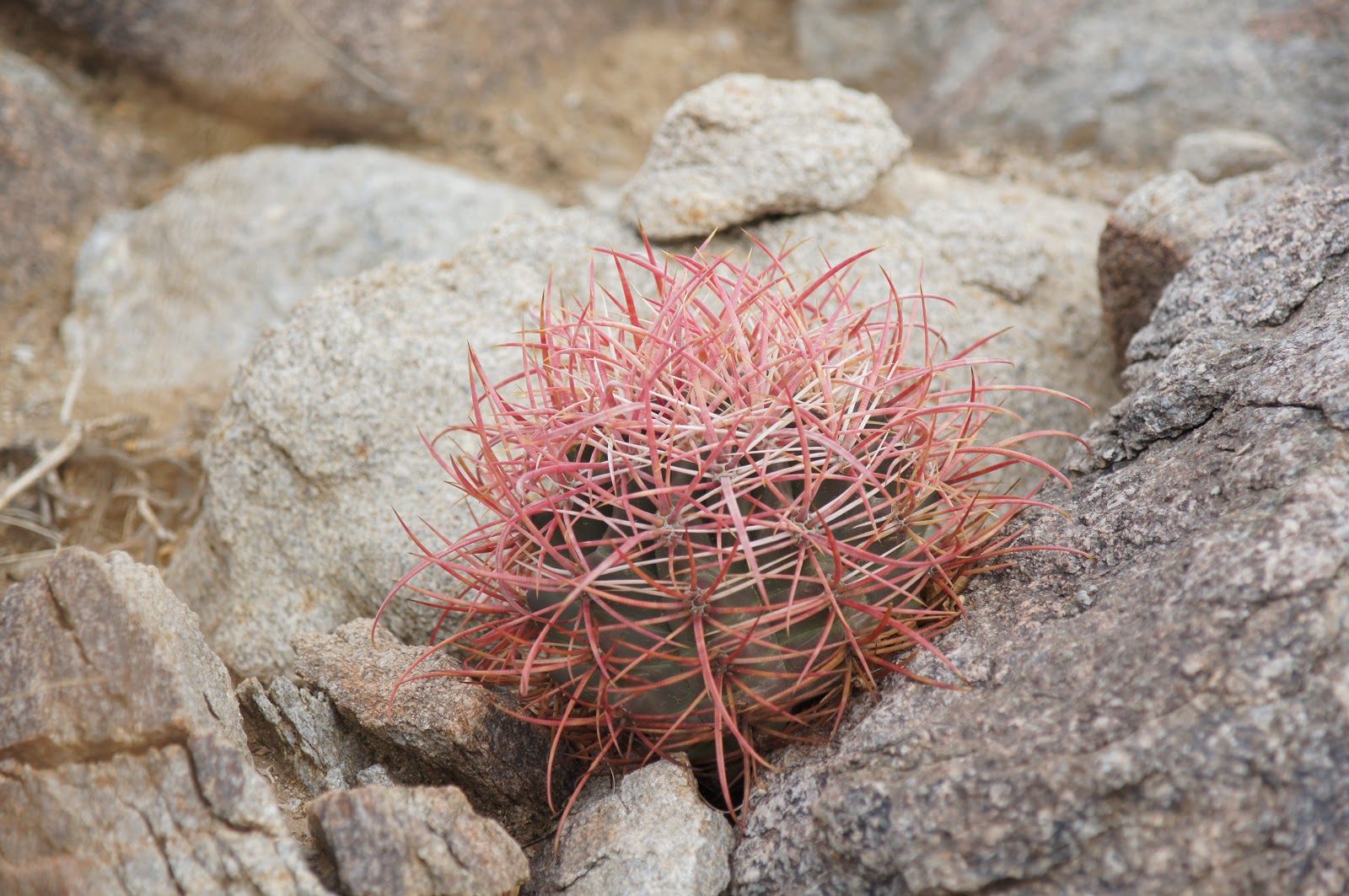
Anza Borrego is famous for its spectacle of spring flowers. At the time we were there, we didn't expect to see anything flowering. So I was much surprised to see some flowers here and there.

A bee visiting a desert lavender. 
Well, something's got to keep all the bees and hummingbirds alive until spring, right?


Most plants were not in bloom, of course. 
Brittle bush
The most common tree there is the cat-claw Acacia, named so after its hook-shaped thorns.


It is a small tree with thin leaves and scant shade. Enough shade though, for a tired chika to rest in.


Many of the Acacia trees we saw were infested with mistletoe - a parasite plant that lives off the sap of its host. 
After about a mile of walking on the dry sand of the wash bed and some minor rock-scrambling we saw our destination - an oasis - in the form of a tight group of fan palms nestled in the narrow, upper part of the wash. Fan (Washingtonia) palms require plenty of fresh water to survive. Their presence, therefore, indicates the presence of water, either openly or not too deep underground.

Borrego Palm Canyon oasis
Below the palms we met open, running water. The chikas enjoyed playing in the water, pulling long strands of algae and skipping on rocks.


Meanwhile I spent time observing the nearby vegetation, which included some unexpected species such as this cattail:
Cattail in the desert
We encountered many people on their way back, and all talked excitedly about seeing a ram above the oasis. We hurried along but were too late. No ram for us. But we did meet another family from the bay area and the chikas immediately connected with their children and before long all five of them were playing hide and seek among the palms and the boulders.

A perfect set for a game of hide-n-seek.
The other family were camping in the campground where we started and tried talking us into joining them, but we had already hotel reservation for that night. After some difficulty in breaking the children's game we left the oasis and headed back to the parking lot. We didn't see the ram, nor any other sheep all the way back.
We had an afternoon picnic by the trailhead, and as we were wrapping up, our new friends made their way back from the oasis. They had taken the alternative trail and yes, they did see the ram ...

Costa's hummingbird, female
Costa's hummingbird, male


December 26
We had our camping gear with us just in case. So after spending the night of December 24 at the hotel in Julian we decided to join our new friends for one night of camping for the next night. The human connection was the major determinant of course, but there was also the hope that if we could make it on the trail at first light we might be able to see some bighorn sheep. So at the crack of dawn we hurried the grumbling chikas out of their sleeping bags and headed into Borrego Palm Canyon once more - this time taking the alternative trail.

Sunrise at Borrego Palm Canyon
We got a bit confused at the beginning of the trail because it leads into an amphitheater and then disappears. We scrambled a bit between the rocks and Cholla cacti until we picked up the trail once more. The still dark canyon provided us with yet another pretty rainbow.


The alternative trail climbs on the canyon side and the chikas, who expected an easy walk 'to the bridge over the water' were grumpy and whined constantly.

We didn't see any sheep. Just awesome desert landscape. The early morning light really brings out the beautiful reddish hue of the rocks.
Not being covered with vegetation, the intricate and magnificent rock formations are laid naked to the eye (and the camera).

We arrived at the bridge without seeing any sheep. So we sat down and waited for them. The chikas, in compensation for the early rise, were treated to what is usually a big no-no in our home - a cookies breakfast.
We waited for a while. Then
gave up waiting and headed back on the main trail. Near the parking lot we met another hiker who informed us that he spotted a ram earlier that morning on the eastern slopes.
"They usually hang out by the golf course," he added. "Why don't you look for them there?"
Well, I didn't come all the way to the wilderness to see sheep grazing on a man-made lawn. That I can see in the bay area pastures.

We did not see any sheep that day. But we did see this little feller:
Black-breasted sparrow.


Sunday, January 6, 2013

Far and Wide: The rolling hills of Briones Regional Park


Date: November 13, 2012
Place: Briones Regional Park, Martinez, California
Coordinates: 37.92741, -122.15872
Difficulty: moderate. 


A beautiful, warm day of fall and I am checking out a potential trail for group hiking. I have never been to Briones Regional Park before, and I was excited to discover an area that's new ground for me.
It took me a while to find the right staging area. After parking by Oak Grove picnic area I took my camera and headed north on Abrigo Valley trail. 

A portion of Briones Regional Park map, containing the trail I hiked (labeled yellow).
Abrigo Valley trail is a wide, packed-gravel road that leads to two of Briones Park group campgrounds, and is very convenient to walk. It begins in the shadow of large oak trees but soon enough the view opens to reveal the smooth hillsides, left and right.

And the wide, blue sky. There were many vultures about. This one, in the picture below, swooped gracefully by me. I assured it I was not dead yet, and it flew away.
Turkey Vulture
After inspecting the Wee Ta Chi campground, where I spotted a late flowering California Poppy, I turned west unto the Santos trail, connecting to the Briones Crest Trail. Unlike Abrigo Valley trail, Santos trail is a narrow path nestled in a hidden valley and trodden mostly by bovines. At times it was hard for me to make out the hiking trail from the numerous cow trails, or to see it at all under the fresh growth.
California Poppy
I trusted my instincts and climbed the creek westward where it seemed the trail was going. On the eastern side of the valley I saw an opposing creek, nourishing a number of trees. In the more arid, eastern side of the East Bay hills, creeks such as this are the main supporters of tree life and all animals that depend on them.

Here's the view of the valley from the hilltop where I connected to the Briones Crest Trail.  The trees peeking from the creek folds of the hills. 

Briones Crest Trail is well marked and easy to walk. The view from there - all around -is wonderful. To the east - Mt. Diablo.


And to the south-east, a peak I did not identify. Isn't it a great reason to go back with a wider map and a compass?
I left Briones Crest Trail to hike the Deer Creek loop trail - the trail I actually intended to test for the group hike. The loop is fairly short but involves a 600 ft elevation change. It encircles the creek near its bank and along the crest of the hill to its west. The creek itself was flowing nicely, but the cattle pond on one of its little tributaries was empty and overgrown with vegetation.


A mile-long trail connects the Deer Creek Trail with the parking lot. It runs between the sloping hills and the Bear Valley Road that borders Briones on the west. A little pond surrounded by a ring of tule grass was alive with sparrows. One of them stood long enough to be photographed:


The entire hike was a little over 5 miles long and took me, leisurely, about 3 hours and was very enjoyable. I am looking forward to my next visit of Briones.

Friday, December 21, 2012

A Royal Swell: King Tide at the Hayward Shoreline

Date: December 15, 2012
Place: Hayward Regional Shoreline, Hayward, California
Coordinates:
Difficulty: easy

Last spring I posted my recommendation of the Hayward Shoreline Interpretive Center (HSIC) as a great place for family hikes and class field trips. Last week my younger chika's class went on a field trip there, which I was happy to chaperone. It was then that I found out it was king tide time for the pacific coast. The water level was low enough for the children to observe mud critters, but water was rushing speedily in and by the time we left the entire area was flooded.
We left HSIC about half an hour before the tidal peak. As soon as I got home and checked the online tidal chart and saw that the last day of the king tide was going to be on Saturday, Dec, 14.

HSIC building is an island
The tidal cycle is caused by the gravity pull of the moon. King tide happens when the sun is aligned with the moon and adds its own gravity pull. The combined pull of the sun and the moon results in extreme tide, called king tide. This king tide reached its highest (7.5 ft) on Dec. 12. On Dec. 14 at 1:13 pm water level reached 'only' 7.1 ft. Not the highest, very impressive nonetheless.

Papa Quail had taken the little chika to a birthday party so I took the older one with me to the Hayward Shoreline. My older chika is very fascinated with royalty, and was excited to go and see the 'king'. We arrived at 1:00 pm and immediately went on the trail.


It was hard to recognize the landscape from what I've seen last spring. We arrived there just before the tidal peak and everything was already flooded. Ponds, slough and vegetation fields alike.
Mallards feeding on tidal floatsome
It drizzled the entire time we were there. The chika started the hike complaining about being cold and itchy, despite of the thick coat and hood she was wearing. I didn't mind the rain as much. My main concern was keeping the camera dry. I did so by keeping it under my poncho and only pulling it out for quick snapshots.
A group of Northern Shoveler ducks enjoying the wide swim area.
We didn't expect to see many wading birds there. We did see many ducks, including this sole Ruddy Duck:
.
Ruddy Duck, adult male, nonbreeding.
We didn't expect to see wading birds but we did see them. Waiting for the tide to recede.

Greater Yellowlegs
Every time I go to the Hayward Shoreline I wonder about this windmill. On my chika's field trip I learned that it is an artistic representation of actual windmills that were used in past days to move water between the ponds. 
A work of art
I didn't expect to see any flowers there at this time of year, but this marsh gum surprised me. Just like the spring flowers there, the marsh gum too is yellow.
Marsh gum
I also noted the progress in building the new power plant. It, too, looked like an island.


Just like last time, we made it to where the slough enters from the bay. The pond, so calm and rich in birds last spring, was full to the brim with turbulent grey water.


A single bird was there - one Western Grebe that kept diving again and again in one place, looking for goodies brought in by the tide. 


Western Grebe
Below the bridge were some remains of the mud nests build by the cliff swallows last spring. The rains have washed most of them off, but in some places there were still muddy remains. One of them even held three abandoned eggs still. 

Remains of swallow's nests. Abandoned eggs in bottom right corner. 
I tried convincing my chika to continue beyond the bridge but at that point she had had enough of hiking in the rain s we turned about and started back. At that time the tide has already started receding so we were walking against the water flow.
Submerged pickleweed
In between the green vegetation we found mushrooms. It made my chika very happy - she loves mushrooms. From that point on her entire attitude has improved considerably. She became excited about everything we saw and didn't mind the rain anymore.


There were plenty of willets huddling together by the slough. They appeared sleepy and uninterested in anything.

Willet
Least sandpipers, on the other hand, took immediate advantage of the receding tide and started foraging the newly exposed ground, even right by the trail:
Least Sandpiper
The great egret that was too far to photograph on our way out had come near the trail. A bright splash of white in the overall grey scenery.
Great Egret
When we got near the HSIC I photographed the marks of the king tide from 12/12. When it was at its highest - 7.5 ft - the water had flooded the trail itself.

What the tide had deposited on the trail
We finished our hike with a visit inside the HSIC where, with the guidance of the naturalists, my chika got to explore some of the house snails. Apparently they emerge from their shells when hummed to.

Rain or shine - the Hayward Shoreline is always a great place to discover bay wildlife. It is an excellent place to feel the pulse of the bay area nature.