Showing posts with label Lee Vining. Show all posts

Wednesday, December 7, 2022

Mono Lake Extended: A Winter Hike at the South Tufa and the Navy Beach


Date: November 26, 2022
Place: Mono Lake South Tufa Area, Lee Vining, California
Coordinates: 37.939077, -119.026976
Length: 1.7 miles
Level: easy


Mono Lake is a pilgrimage site for me. No matter how many times I've been there already, I never miss an opportunity to visit there again. Any time of year it offers magnificent sights and calming feeling. On our last Thanksgiving break at Mammoth Lakes, it was the elder chika who came first with the request of going to Mono Lake. Needless to say, I didn't argue. 
This was the second day on the break that we dedicated for hiking. Yesterday we hiked to the Inyo Crates and then went to stomp around the snowy streets of the ghost town of Bodie. Today was Mono Lake day. We set out late that morning. We stopped briefly at the vista point south of Mono Lake to take a look. The sky was cloudy and a chilly breeze blew in our faces. A large blanket of fog covered the lake. 
Fog over Mono Lake
 
When we reached the South Tufa Area parking lot we saw that we weren't alone. A number of cars were already parked there, and two people were standing quietly by the trailhead. The chill was penetrating and I was glad I convinced my chikas to wear their ski base layers on like I did. The place was eerily quiet and we couldn't see and animals. This wasn't my first time seeing Mono Lake in the snow, and still I find it amazing how completely the area transforms into an outworldly magical scenery.
Trail to the waterfront

All of our previous visits we only did the short loop trail, to the lake and back. Now we had the chance to extend our exploration and go on the (somewhat) longer loop and also visit the Navy Beach site. The chikas didn't argue. 
Our hike as captured by my GPS

This time I didn't take many photos of the tufa formations as in previous times. As I already noticed on my most recent visit there last July, the formations have deteriorated significantly. I don't know what's the reason but the widespread deterioration suggest a powerful storm damage. The remaining tufa is still quite impressive though, and as we neared the lake we also started to see little animals here and there. 
Chipmunk

On our way down to the lakeshore however, the elder chika noticed some movement in the tufa to the east. These were wild horses! Four of them. It was the first time we've seen wild horses in that area. I wondered how close the horses were to the Navu Beach trail that I wanted to continue on. The lake shore, which in warmer seasons is crawling with brine flies and shorebirds that feast on them, was quiet and serene. The very few birds in the water didn't do much to stir as much as gentle ripples, and the surface was calm. The cloud cover was beginning to break up, irregularly lighting sunny spots in the scenery. 
View northeast

The one shorebird that we did see by the waterfront was a killdeer. This usually noisy bird strolled along the water line in silence. 
Killdeer

While the elder chika was counting (on one hand) the birds that she did see, I squatted by the water, trying to capture the surreal image of the clouds reflection in the mirror like Lake's surface. The water's clarity made the underwater features blend with the sky's reflection, creating the effect of an ethereal world. 
Reflection

In the west the clouds cover was still pretty thick, but a hole was beginning to form and I could see some Sierra Nevada peaks 'floating' through the hole in the clouds. 
View northwest

Directly to the north a hole n the cloud let the sunlight through and Paoha Island was lit beautifully. The low fog that covered Black Point on the north shore of Mono Lake was also illuminated and looked like a fluffy cotton layer, almost indistinguishable from the white snow. 

In the warmer seasons Mono Lake is teeming with life and there are many birds that come to feast on the local brine shrimp, brine flies, and other critters. Some bird species also nest on tufa and on the lake's island, protected from land predators. Now most of the birds we are used to seeing there were gone. No phalaropes or gulls in the water, no blackbirds roaming on the shoreline, no raptors in the air. The lake wasn't completely abandoned though. There were a few ducks and grebes in the water. They were floating so peacefully that they hardly disturbed the surface at all.  
Ruddy Duck

We meandered slowly east along the shoreline, following the thin path of footprints in the snow. We encountered a few other people among the tufa pillars, all of them quiet, huddled in their coats. It seemed to me that we were the only people there who were visibly and audibly happy. It might have contrasted with the serene air of the place that morning. 
Tufa 

In one of my previous posts about Mono Lake I mentioned that I love naming the formations. Now we were approaching the one I named 'The Sunken Ship'. The reflection was so perfect that I couldn't stop clicking my camera at it. The header photo is of this formation from a different angle after the clouds separated a little more.

Meanwhile the elder chika was appreciating the brave grebes that remained in the lake in such cold weather. I don't know if they over-winter there. If so, what they eat.
Eared Grebe

There were also a few ducks on the rocky shore. Click on the photo to see them - they blend very well with the broken tufa background.
Green-winged Teal

The tufa pillars are perfect for osprey nesting. Mono Lake is devoid of fish but there are numerous fresh water lakes in the area for the osprey to feed. In the winter of course, the lakes are frozen and the ospreys migrate to where they can hunt, leaving their empty nests behind. I asked my chika to photograph the empty nest too.
Osprey Nest

We moved out of the main tufa area with the large formations and started moving east towards navy Beach. During the Cold War the Navy held experiments in that area, including explosions. Nowadays the beach is an access point for kayaks and SAPs going on the lake. There weren't any that day, not surprisingly. In fact, in all of my visits to Mono Lake, only once did I see kayaks in the water there.
View to Navy Beach

The wild horses were very close to the trail leading to Navy Beach. They were so close that even I could take decent photos of them with my wide view lens. I feared that they might be blocking the trail but they were a bit off to the side. My young chika was a bit stressed by their presence but the horses appeared to be completely chill about us walking near them.
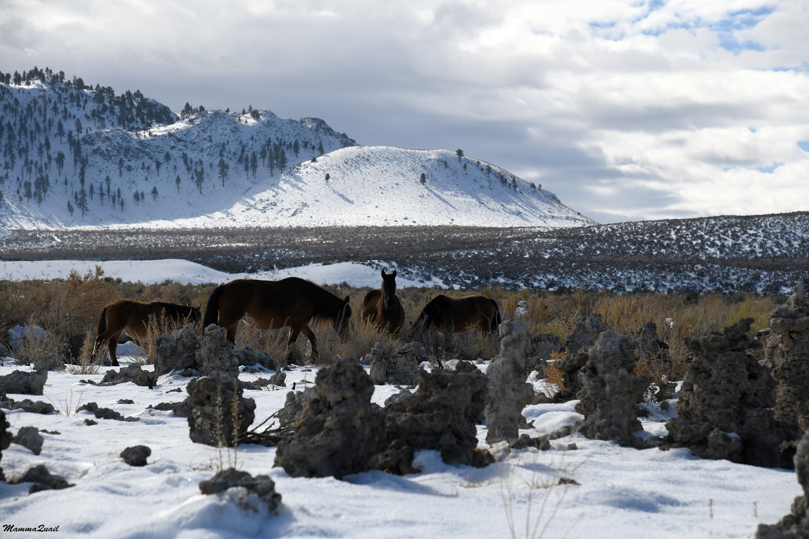
Wild horses on the Mono Craters background

Nearly all the tufa around the Navy Beach was broken off, I assume because of the navy's activity there. It was sad to see the broken tufa but also interesting to see the inside of this formation, which precipitated while still under water before the city of Los Angeles started diverting the lake's water sources.
Broken Tufa

The Navy Beach has a viewing platform at the line where probably the lake's level was in the 50's. By the time we got there most of the fog and clouds were already burned off and we enjoyed the new warmth of the direct sunlight. The water looked very calm but my elder chika detected some movement on the shore and walked down to see what it was. 

That gray bird that hopped on the shoreline was flashing red in its wings when it flew, just a short distance away, and settled atop a tufa pillar, one of the few that remained standing at the edge of the Navy Beach. It was a northern flicker. 
Northern Flicker

While the elder chika was busy stalking the flicker I remained on teh viewing platform with my younger chika. We chatted and enjoyed the great view all around us.  
Broad view west to the South Tufa Areas

The massive Sierra Nevada mountains looked smaller from where we stood. They are no small by any means of course, Mono Lake itself is on a high plateau. More so was the angle of my photograph, focusing on the large field of snowy brushland and the vast sky, leaving the mountains as a thin divider line. 

I zoomed on the 'Sunken Ship' formation. This was the first time I was in Navy Beach and it was nice to see the South Tufa area from this direction. Now the mountain loomed tall and impressive over the lake. 
Mono Lake

The elder chika returned and we started walking back to the larger loop trail that would take us to the parking lot. The wild horses had moved while we were at the Navy Beach and now they were clearly right at the trail. My younger chika voiced once more her concerns about going near the horses. I understood her concerns, horses are large and majestic and can be dangerous if threatened or spooked. This group of horses however,  looked very much at ease. I told my chikas to walk gently and refrain from loud voices and jerky movements and anything that might spook them.
Wild Horse

We actually got very close to the horses before they started moving away from the trail, and even that they did very slowly and nonchalantly. A large mare that appeared pregnant remained on the opposite side of the trail from the other three and eyed us as we walked by. She was at home there, and she knew it.

After passing the horses we turned on the loop trail and quickened our pace, going back to the parking lot. It was just about lunch time and the chikas made sure to notify me that they were hungry.
Trail

We had lunch in June Lake, then drove north to Bodie Hills where we planned to do some more exploration after our too short a visit there the day before. As we drove past Mono Lake on our way north I had to stop at a large enough pullout to properly appreciate the fantastic reflection of Black Point in the lake's mirror surface.

This was the last complete hike we did on our 2022 Thanksgiving break. We did some strolling around Bodie Hills, more of scouting a potential hike rather than actual hiking. There's much to see in that area and I'm sure we'd go there again. As for Mono Lake, that too will call me again, like a magnet, next time I visit the Eastern Sierra.


Thursday, January 27, 2022

A Worthy Alternative for a No Ski Day: A Windy Exploration of the Panum Crater

Panum Crater


Date: January 7, 2022
Place: Panum Crater, lee Vining, California
Coordinates:
Length: 2.3 miles
Level: moderate
 
The chikas had their winter break extended through the first week of January, so I booked us a ski week in Mammoth Mountain Resort. On our forth day there however, the winds were simply too strong to do any skiing so we decided to go hiking instead. I received a wonderful list of recommendations for hiking trails from members of the Eastern Sierra group and Panum Crater was my first choice for that day. Panum Crater is a small volcano located near the southeastern shores of Mono Lake. Every time we visit the South Tufa area of Mono Lake we drive past that volcano, and each time I tell myself that one day I'll go up there and explore. That day has come at last.

The access road to Panum Crater is a dirt road exiting from highway 120. According to Google Maps hwy 120 is seasonally closed from its junction with highway 395 but that's not true - it is closed further east, past the South Tufa area.
There is a small parking lot by Panum Crater, with an information kiosk, but nothing else. I looked at the trail leading up to the crater's rim and decided that we didn't need our snow shoes for that. A short distance up that trail however, I turned back to the car to fetch my hiking poles - the trail was too slippery.

It's a quarter a mile hike up a mild slope to the rim of the crater. There was a great view from there of the snowy road we came with, through the big flat that lies northwest of the Mono Craters.

Panum Crater is a plug volcano, meaning the magma rose up slowly, forming a lava dome in the crater's center. Lassen Peak is also a plug volcano, a much, much larger one. 

There was a trail going up the plug but the chikas and I chose to go around it along the rim trail.

Panum Crater Magma Plug

The rim was fairly narrow and the whipping wind made it hard to walk while maintaining our balance on the narrow path. The crater's slopes were not  all that steep but it would have been unpleasant to roll off to either side. I was glad to have brought my hiking poles and soon I relinquished one of them to my younger chika, who struggled hard to maintain her footing.

The inner side of the rim reminded me of a castle's moat, protecting the plug from outside invaders. I wondered if it ever gets flooded.

The 'Moat'

The wind aside, the air was clear and the sky mostly sunny. There was a great view all around and I loved seeing the Mono Craters all white with snow. The Mono Craters were also high on my list of hikes for today, but eventually we didn't - the brutal wind made even the relatively short and easy Panum Crater hike a challenging one for us.

View Southeast

We curved around the crater counterclockwise. On the east side I saw a large pine growing on the inner slope of the rim. I guess it does accumulate enough water there to support a full grown tree.

the other side of the rim, view to the northeast, was Mono Lake in its (modern era's) full glory. The South Tufa area looked so small far below! I regretted not having my regular camera with me. Not having planned for any hikes on this trip I had left it at home. All the photos poster here were taken on my phone and I didn't want to zoom in fearing I'd get a too low resolution image. We had visited the South Tufa area only three days before, when the high winds made us quit skiing after only three hours.

Mono Lake

 Curving westward, I saw more trees growing inside the rim's perimeter. As expected, the north-facing side supported more plant life.

The rim isn't level. Going counterclockwise meant a steady uphill walk. That walk would have been easy on a dry surface and low wind conditions. The steepest part of the rim however, was on the crater's north side, and the snow cover there was deep and slippery, and the powerful wind slowed our progress to a crawl.

The Rim

We completed the rim trail. I looked wistfully at the plug but the chikas wouldn't hear of it. I looked down at the parking lot and noticed another vehicle there. As I watched, the other car took off and went back toward hwy 120. I pulled the car key out of my pouch and handed it to my chikas, telling them to go down to the car on their own. I knew I wouldn't have another chance to explore this place anytime soon and I wanted to go up there now. I told them I won't be long but I knew they didn't mind - there was cellular reception there and they'd be busy with their phones for a long while before getting impatient.

We separated ways. The chikas went down the outer slope to the car and I went down the inner side, to the plug trail. The trail down was covered in deep snow and for a moment I regretted not having my snow shoes with me. But the connector trail was pretty short and soon I was at the base of the plug. I took two steps up the trail and stopped. I had just remembered that is was about lunch time, so I took my mittens off and texted the chikas a reminder that there were snacks packed in the trunk. Now I was sure that they won't call me down too soon.

Up the Plug

The way up the plug was strewn with interesting, colorful rocks. I knew they were all of volcanic origin, but that's where my knowledge ended.

Volcanic Rock

Except for obsidian. I knew that rock from its shiny, black glass-like appearance. I knew of it's usefulness to the native people here when their ancestors lived according to their traditional ways. The local Monache people made arrowheads from obsidian, and they traded it with other nations too, for it was a very valuable commodity.

Obsidian

It was a short hike to the top of the plug but there the trail ended. I could see where hikers before me had walked, forming little paths between the rock formation. I knew I could stay there for a long time, exploring the place.

Lonely Bush

Two large basalt formations were the most prominent feature up the plug. They were the summit pinnacles of that little volcano. I was too close to them to be able to capture both in a single frame. Even one was difficult to capture in a way that shows its grandeur. I couldn't back away for perspective because I already was at the edge of the plug.

The Summit Pinnacle

From up close though, I was able to inspect the features of the volcanic rock. There were many of them. I liked best the circular patterns in the photo below.

Rock Pattern

I meandered to the north side of the plug. From there I could capture both summit pinnacles in a single frame. In the backdrop of the black basalt rocks are the snow-covered Mono Craters (left) and the Sierra Nevada mountain range (right).

The Summit Pinnacles

The day, which started bright with mostly blue sky, has darkened. The wind intensified, and ominous-looking clouds were rushing east over the mountains. A storm was coming, it was time to go back.

The Storm Rolls Over the Sierra Nevada

I made my way down the plug, back up the rim, and down the outside slope to the parking lot without stopping for any more photos. The wind seemed to blow right through my winter clothes. I was alone on the trail but I had my COVID mask on my face nonetheless, just to block some the wind. I opened the car's trunk and threw my poles inside and I noticed that the elder chika was sitting in the driver's seat. Without saying a word I closed the trunk and slid into the passenger seat next to her. She looked at me with mild surprise and then grinned and turned on the engine. This little snowy dirt road was a perfect off-asphalt first for her, and she made sue I documented the event and sent the photo to Pappa Quail to be proud.

Road Out

It was past lunch time when we were back on the road. Lee Vining was all closed up so we ended up having lunch in June Lake Village, where we stayed indoors watching the snow flurries coming down. All that wind, but only flurries to show for it. When we finished lunch we drove to Silver Lake trailhead at the end of the road and snow-shoed around until nightfall. Not having skied that day turned out not to be a downer after all because we had a very cool hike at a most fascinating and beautiful place - the Panum Crater by Mono Lake.


Many thanks to members of the Eastern Sierra group for recommending this hike! 

Saturday, November 13, 2021

Into the Narrows: The Rock Fissures of Black Point


Date: April 9, 2021
Place: Black Point at Mono Lake, Lee Vining, California
Coordinates:  38.028010,-119.084704
Length: 3 miles
Level: moderate
 

At the tail of our spring break in the canyons of Utah we returned to California by route 395 and the Eastern Sierra with the goal of checking out a few places on my constantly updating 'must see' list. On of these places was the Black Point butte on the north shore of Mono Lake. Usually we visit the South Tufa area where the spectacular rock formations are and the chance of observing interesting desert birds and other wildlife. Once we did go to see the North Tufa Mono Lake Park, which was nice, but we haven't done much exploration of any other part of the Mono Lake area. 
Black Point came on my list after a visit from a friend and her family. They did a big road trip around California. I helped them plan their trip and they added to it a great deal of their on sightseeing and exploration. When they returned from their travel they shared their own findings with me, and Black Point was one of their discoveries which immediately inspired me.
After our little exploration of Hot Creek we drove to the little parking area of Black Point. The road there becomes a sandy single lane dirt path at northeastern edge of Lee Vining, a short distance past the North Shore County Park. The path goes around the north side of Black point, then curves south and ends in a tiny parking space east of the butte. There was one care already parked there. We parked near it and stepped out to a gorgeous and outlandish scenery. 

According the the description I got from my friend and the accounts of other hikers that I later read online I knew not to expect any established trail. Indeed, there wasn't any. The features that I was specifically interested in were volcanic fissures, and the instructions of finding them were simply to get to the top of the hill and look for them west of the summit. 
Our hike as captured by my GPS

There were numerous tracks of human footprints ascending directly uphill. We chose that which looked most direct and followed it. 

The slope wasn't all that steep but going up was more physically demanding than it appeared. Going up the soft cinders felt like hiking up a sand dune. I paused every now and then to look at the view which opened up with each step I took uphill. 

Mono Lake view southwest to the Sierra Nevada 


A flat salt-crusted island was visible close to the north shore. There must have been quite a wind there because a dust devil was dancing on the salt flat. 

Little lizards were sunning between the shrubs and scurried away as we past them. They were numerous, and also very quick to run and hide.

Black Point is one of those hills that whenever you think you see the peak and you get near it, it turns out that there's another would-be peak a bit higher. We encountered a few of those on the way up but eventually we did see the real peak before us, and we headed there. 

Once we got to the rocky part of the hill the climbing became much easier. on the other hand, because there was no trail we needed to find the best way to get to the peak on our own. We had different opinions on the matter so we ended up splitting, each of us ascending by a different route. 

View northeast

The first one up was the elder chika, my mountain young goat. I came up second, far behind her. Pappa Quail lingered behind to stay with the younger chika who took her time getting up the hill.

The view from the peak was fantastic. What surprised me was how high I felt on the peak of that relatively small butte looking at the majestic eastern peaks of the Sierra Nevada range. 

The volcanic nature of the hill was evident everywhere. I liked the nuggets of what looked like granite embedded in the volcanic ash rock. 

Standing on the peak of Black Point I looked around for the fissures. There was a big dark line to the west that looked like it could be that. I called my family and we climbed down from the peak and headed west to that dark line where it looked like the ground had opened up. 

The Fissure

It wasn't a straight-forward walk to that dark line we saw from the peak, but when we arrived there we saw that indeed that was a large fissure in the volcanic rock. 

Fissure

We approached the fissure where it was shallow and the walls were collapsed at several points so it was easy to go down and take an inside look.

There was a dark lizard on the wall. I photographed it, but Pappa Quail and the elder chika both got better photos than me. And they didn't even get down the fissure. 

Northwestern Fence Lizard

The fissure got deeper and I tried going down directly but my way was blocked by a large boulder. There was a steep drop on the other side and I didn't want to risk trying to descend there so I climbed back up above the fissure line. 

It didn't surprise me that Pappa Quail wished to stay up but I expected my chikas to show more enthusiasm about these cool geological formations. Apparently they were too tired and didn't feel like going down the fissures. In fact, they kept asking when will we get back to the car already. I told them they could go down already, but Pappa Quail convinced them to stick with us until I was dome exploring. I didn't argue, I simply dropped down the big fissure at the first passable entry point. 

The dirty white bottom I saw from above turned out to be old snow. I was excited to see the leftover snow so late in the season. It showed that the inside of the fissure was keeping the cool temperatures much longer than the surrounding area. I had to watch my step though. Although old, the snow was still slippery. 

I moved further into the fissure, not worrying about how I'll get back up. I figured I could always backtrack and exit the way I entered. As I moved forward the fissure got deeper and narrower, it's walls closing in on me. 

It was getting late in the afternoon but there was plenty of sunshine outside. Inside the depth of the fissure it was fairly dark, however, and only a narrow stripe of bright sky was visible above my head. 

Looking up

One of the strange things that I saw inside the fissure was the stucco-like partial coating of the fissure walls. It looked human-made, but was completely natural. 

I inspected this 'stucco' closely. Later I asked about t at the California Geology Forum page and was told that this was tufa, a calcite deposit that precipitates when calcite-rich water evaporates. That implies that Black Point fissures were once below the surface of Mono Lake. 

From a side view it did look like something that was added on the pre-existing fissure walls. 

Pappa Quail called me from above. The chikas were really eager to get off the hill. I started looking for a way out. There were plenty of dead-end corners in the fissure, but soon I came upon another collapsed area where I could climb up and exit the fissure with little effort. . 

Looking along the fissure from above I could see that I would have needed to get out soon enough anyway because it became to narrow for me to walk though. It did seem to get wider later on but my family were already turning to walk down the hill. 

We didn't go back to the summit of Black Point but circumvented around it in the general direction of the parking area. 

Going down was much quicker, naturally. The difficult part was finding a less thorny route between the desert shrubs. 

Soon I was at the lead - not a normal place for me. Perhaps it was the lack of wildflowers, or that Pappa Quail and the elder chika actually encountered birds on their way downhill. 

Brewer's Sparrow

There weren't that many birds there, but enough to make my two birders pleased, and the elder chika glad that we did go there after all. 

Northern Harrier

Even I saw some of the birds but I trusted my family borders with their big zoom lenses to capture the photos. 

Rock Wren

I came down the hill facing east where the peaks were low volcanic buttes devoid of snow. Mono Lake to the south was belted with a wide salt band at its north shore. I felt compelled to go down to the water but I didn't think that Pappa Quail and the chikas would want to remain in the area any longer. 

Mono Lake

Earlier that day the plastic gravel protector at the bottom of our car came loose and was dragging on the dirt road. Pappa Quail showed his MacGyver skills and tied the thing with a piece of wire we found on the ground where it happened. Now however, he wanted to secure it better. When we got back to the car he pulled his multitool and slid under the car. He said he didn't need my help so I announced that I was going down to the waterline and invited the girls to join me. The young chika grabbed her book and sat down in the sand near the car, making her statement. The elder chika perked up when I mentioned that there should be birds in the water. 

We walked down   a wide belt of mostly dry vegetation, stepping on a narrow path that previous visitors had etched in the land. 

Between the dry grass belt and the was another wide belt of black volcanic cinders, contrasting beautifully with the white of the salt sediments and the blue water. What astonished me though, were the many dead plants, all of one species, that stood at the cinder belt like outworldly ghosts. I asked about these later at the California Native Plants Society page, and learned that these were giant blazing star, a common annual wildflower. Their bloom season would be later in the summer, but it was early April and these were all dead and I didn't see any new germination. 

A Blazing Star Cemetery
 
 I inspected them closely. The dry casings of once lovely green plants with big yellow flowers. The blazing star is an annual plant, but these looked like their lives were sucked out in an instant, living the empty dry body behind them like an old molt cast aside by a dragonfly nymph turned adult.
Giant Blazing Star, Mentzelia laevicaulis 
 
When we approached the salt belt it no longer appeared as a uniform salt field but showed much texture of sediment varying in size and shades of white, off-white, and gray. The contrast with the black sand and the blue water was striking.

As the water sources to Mono Lake are still being diverted by the city of Los Angeles, and after this year's drought, there was quite a lot of freshly exposed sediments near the waterline, the smallest of which looked like popcorn.

The elder chika went directly to the water in search of birds. I got distracted by the hoards of brine flies that sat right at the edge of the water. They moved in waves as I stepped near, and settled down a couple of yards away.

Brine Flies

Gentle waves rippled the water, diffracting around the tufa deposits that poked through the surface. The calm movement and the near complete silence permeated my soul.

There were only a few birds in the water, all of them grebes, and none of them very close. They were in breeding plumage and swam about in pairs. The elder chika took a few photos and said she wanted to go back to the car.

Eared Grebe, breeding

I took a long goodbye look at the waterline, this time to the west where the remains of Sierra Nevada snow shone white in imitation of the brilliant white salt deposits on the lake shore. This place was truly magical.

On our way back to the car I noticed something I didn't see on our way to the water - there were numerous anthills dug in the crusted sand. The anthills looked freshly dug, but no ant was visible outside them. I assume they are of a nocturnal species. I also wondered what do they eat. Perhaps dead brine flies?

Anthills

We got back to the car. Pappa Quail was still underneath it so we dawdled around a bit more until he finished securing the gravel protector to the body of the car. The sun was getting low and the chikas were hungry. We got into the car and drove back to Lee Vining where Pappa Quail convinced the chikas to stop for a short visit of the North Tufa Park to see if there any birds there. The sun was down when we finally arrived in town where found only one eating place open for business, and even there we arrived almost before closing time.


Many thanks to the members of the California Geology Forum for the information about Black Point.

Many thanks also to the members of the California Native Plants Society for their help in identifying the blazing Star.

A post edit: upon reading this post Pappa Quail commented that I forgot to mention that the wire we found didn't quite work to fix the gravel protector so I had to sacrifice the low E string of my guitar, and that did do the job. 


Never miss an opportunity to visit Mono Lake. Seriously.