Thursday, July 24, 2014

Alone in the Woods: at Mill Creek Falls and Around Clear Lake

Date: April 24, 2014
Place: Mill Creek Falls and Clear Lake, South Warner Wilderness, Alturas, California
Coordinates: 41.276772, -120.288342
Length: about 3 miles
Difficulty: moderate

Click on the photos for a larger view.


We had originally planned to camp at Mill Creek Falls campground the night before, but had chosen to camp at Stough Reservoir campground instead (and a good thing too, because at Mill Creek Falls campground there's no readily accessible water and the pipes were not yet running).
But we still had every intention to hike the Clear Lake trail, and that's where we went after breaking camp at Stough Reservoir.
The Clear Lake trailhead at Mill Creek Falls campground. 
The Clear Lake trail begins at the Mill Creak Falls campground. Needless to say, we were the only humans around.
Map downloaded from USGS website. Our hike is labeled (approximately) in yellow.
It was overcast and a bit chilly, but not raining. We found the trailhead and started out hike. Almost immediately I saw some spring flowers by the trailside. This particular one, the Oregon Grape, can grow into a quite large shrub, but all I saw there were relatively little plants, that were just beginning to bloom.
Oregon Grape (Berberis aquifolium)
For about half a mile the trail ascends mildly on the hillside, in an open conifer forest.


We aimed for the Clear Lake loop trail, and so took the first turn to the left. This turn, which wasn't marked on the map we had, had led us to an overlook of the Mill Creek Falls.
I want to clarify that this name titles more than one waterfall in California. If you search the web for Mill Creek Falls, this one isn't the first to come up ...
Mill Creek Falls
The waterfall is very pretty. What we didn't know and took some time to find out was that the Mill Creek Falls trail isn't part of the Clear Lake loop trail. Once we cleared that confusion we backtracked our steps to the main trail and continued on eastward.
Goosefoot Yellow Violet (Viola purpurea)
And then we saw the lake, and it was indeed clear.
The sky wasn't, though, and it started drizzling a little. We tucked the cameras under ponchos and went on along the south lake shore. 
Clear Lake, view from the southwest.
It drizzled for some time, but we kept on going. The birds were quiet and we didn't see any other animals or new flowers.
Clear Lake, view from south shore
There were a few waterfowl in the lake itself, but not many, and none that we haven't seen before. But the lake has its own beauty, which the birds just augment with a perfect color match:
Can you find the bufflehead ducks in the lake?  (Photographed by Papa Quail)
At the southeast of the lake the trail disappeared under the water. For some time we wondered what was that all about. Then Papa Quail spotted the neat wooden dam that was holding the water there. Turns out it was a beaver that flooded our trail!

Beaver dam on upper Mill Creek
I waded  in the shallows until I got to higher ground and found the trail again and then the rest of the family joined me, some climbing through the brush and some wading, with varying levels of complaining and/or swearing.
But we all made it to the other side!
Upper Mill Creek
By the time we crossed Mill Creek to the north side the drizzle had stopped. The Creek bed was overgrown with willow trees that were just beginning to bud. It was beautiful, yet a bit eerie to walk through them.
Path in the Willows
The north shore trail is higher on the hillside, providing more view points.

Clear Lake, a view from the north shore
In the map we had, the trail pulls away from the lake at the north east side. Perhaps it is so later in the season when the water level is lower, I don't know. When we were there, all the loop around the lake was very close to the water.
Clear Lake, view from the north shore
Fallen logs accumulate at the east end of the lake, right where the water bottleneck is. There, Clear Lake shows its mirror quality.
Clear Lake
It was there that we finally got to see some birds. Papa Quail waited patiently for them to pop into clear view.
Red-breadted Nuthutch

As far as I could see, this lake isn't a dammed one, but narrows naturally into lower Mill Creek through a short rapids section that eventually leads to Mill Creek Falls. Close to the lake's spillout the trail crosses the creek on a small wooden bridge. It was right there, at the lake's bottleneck that we had the most rewarding encounter of that day.
Mill Creek flowing from Clear Lake
As I approached the bridge I overheard Papa Quail explaining to the elder chika about the birds he wanted to see most. Among them was the American Dipper, which we only saw once, about 11 years ago (in Yosemite) and we didn't have a picture of. Not a minute after he finished explaining to her how the dipper looks like and she raised her arm and pointed to the rapids at the lake's exit and cried: 'Dipper!'
And sure enough ... there it was!
American Dipper
The dipper is a very interesting bird. It's a songbird, about jay-size, that lives by clear streams and dives into them to forage for insect larvae and other little stream critters. Its blood temperature drops during winter to avoid hypothermia when dipping into the ice-cold stream. Amazingly, it can withstand the strong rapids currents and emerge exactly at the same spot where it took the dive.
We watched it dive for a few minutes until it flew away.

Shortly after we crossed the bridge back to the south side of the creek we met the main trail again and headed back to Mill Creek Falls campground.
On the way I photographed this slope with this pretty grass that looks almost as if it was intentionally planted there. I could see no evidence of any human meddling there,though, so I assume it looks so naturally.
Grass, perhaps a Stipa species?
The campground was empty still. We selected a nice campsite and sat down for a late lunch picnic. Knocking sounds from above distracted Papa Quail, who pulled his camera from the car and went looking for the source of the sounds.
And he found it.
Black-backed Woodpecker (female). Note the wood chip flying across her wing :-)
This hike concluded our Modoc experience for this trip and left me with a huge taste for more. Next time we will probably go there later in spring and might see more flowers, but all and all, I must say that I really enjoyed the early spring quiescence in the woods, and cherished being alone in the wilderness. I'm certainly looking forward to my next visit to Modoc!


Saturday, July 19, 2014

Too Late for Winter, Too Early for Spring: Cedar Creek and Stough Reservoir

Dates: April 23 and 24, 2014
Place: Cedar Pass, Modoc County, California 
Coordinates:   Upper Cedar Creek: 41.554335, -120.262592 ,  Lower Cedar Creek: 41.534199, -120.224428 ,  Stough Reservoir: 41.562343, -120.254996  
Length: Complete Cedar Creek Trail (one way): 3.5 miles. Around Stough Reservoir: about 0.6 mile
Difficulty: easy

After our visit to Modoc NWR we went back to Alturas for a late lunch and some decision making. We had planned to camp for the two flowing nights at one of the South Warner Wilderness campgrounds, but the weather forecast wasn't looking very camping-friendly.
After a friendly discussion we had with our diner host we decided to change our plan slightly and go to hike and camp at Cedar Pass.
Swainson's Hawk by the road side on the way to Cedar Pass
There is a nice trail alongside Cedar Creek. The full trail is about 3.5 long, but we had just one car and not enough time to hike it fully back and forth, so we just walked in and out some distance from each end of the trail.
The upper trailhead is at the small ski area of Cedar Pass. There's restrooms there, but little else. I found the trail information post and photographed it, as we didn't have any other trail map with us.
Cedar Creek trail, photographed from a sign at the trailhead. Our hike is labeled yellow.

But there is really no need for a trail map there. The trail is well marked and maintained, and there was no problem of following it. In a couple of spots it was still under snow, but nothing we couldn't deal with either by going around or by stepping carefully over.

Close to the upper Cedar Pass trailhead
A major reason for choosing to hike at the Cedar Pass area was a birding brochure I picked up at the BLM headquarters in Alturas earlier that morning. The brochure listed a few bird species that we've never seen before, and while Papa Quail kept searching the treetops, I payed closer attention to the ground.
Sagebrush Buttercup (Ranunculus glaberrimus)
The elevation of Cedar Pass is 7100 feet. April is just the very beginning of spring there. A few sagebrush buttercups and some budding Ballhead Waterleaf were all the flowers I found there. 
Ballhead Waterleaf (Hydrophyllum capitatum)
Papa Quail didn't have much success either. All he saw was a little yellow-rumped warbler that kept teasing him from the foliage, never assuming a camera-friendly pose.
The chikas, on the other hand, had a great time everytime we encountered a nearby snow patch.
Lingering winter remnants
There were no other people around. We enjoyed much the quiet walk in the woods along the snow melt-fed Cedar Creek, but after about a mile we turned around and headed back to the trailhead.
A Cedar Creek tributary
Papa Quail wanted to take a look at the lower Cedar Creek trail, just in case the birds he was looking for were hiding there.
There's no parking lot at the lower Cedar Creek trailhead, just a large pullout. No bathrooms either. The creek is about 40 feet below the road and the woods there are a bit more sparse than at the upper end of the trail. Not very surprising, considering that the lower end of the trail is located east of the mountain pass.
Cedar Creek, a view from the road
   Cedar Creek must have picked up a few more tributaries on its way down, because the current was much stronger by the lower trailhead.
Cedar Creek
The lower trailhead, other than being lower in altitude, is also east of the mountain pass, meaning the area is gets less precipitation. It was actually sunny and nice there.
We could here the birds. Didn't see any, though. The flower situation wasn't much different. Buttercups in the shady areas, and in the sunny patches, caught my eye only two invasive weed species: the alyssum and the bluegrass.
Alyssum simplex, non-native
Usually green, and not as spectacular as lilies of orchids, grasses can be quite beautiful nonetheless. Many grasses are also among the most successful and widely spread species in the world. Invasive old world grasses make today an overwhelming part of open land plant communities, and have in many places in California, completely changed the water economy in the soil and the overall fire dynamics in those areas to favor more wildfires (most of the invasive old world grasses are annual and dry-out completely, and are very flammable).
But they are beautiful :-)
Bulbous Bluegrass (Poa bulbosa), non-native
Fall colors are very appealing. Spring colors no less so :-) 
A mix of evergreens and deciduous trees at various budding stages.
I love the pasty-white bark of naked Aspen trees.
Quaking Aspen (Populus tremuloides)

The birds were hiding and the wind picked up considerably. It was also getting late and we still needed to find a campsite and cook dinner, so we turned about after less than a mile of strolling along the creek, and headed back to the road. Next time we visit Modoc I hope to hike the entire Cedar Creek trail.

The Modoc National Forest campgrounds in the area were open for use, but without any running water yet, so we were aiming for the Stough Reservoir campground, which is very close to the Upper Cedar Creek trailhead, meaning high near the pass.
Stough Reservoir 
The campground is small and away from the main road, and was completely empty when we were there. We were alone in the woods.
We chose the site nearest to the water and were soon racing to get our tent up and cook dinner, because the wind was getting stronger and stronger by the minute. The moment Papa Quail and the chikas vanished inside the tent the flurries started. I finished cleaning the dinner table and entered the tent myself, expecting to wake up to a white scenery.

Snow-capped peak overlooking Stough Reservoir
It took me a long while to fall asleep. Not only was the wind whistling loudly, there was also an even louder chorus of frogs coming from the reservoir.
I laid in my sleeping bag and listened to the passionate frogs calling their lungs out, and to the banging of the wind at the tent, which lasted well into the wee hours of the night. While I do not intentionally go camping when this kind of weather is expected, I do find that it enhances my nature experience.
Papa Quail does not share my view of camping in less than optimal weather, so our night at Stough Reservoir campground was to be our last night in Modoc County for this trip.
As it turned out, the wind died down half way through the night and there was no snow on the ground when we emerged from our tent in the morning. It was very cold, though, and after a quick breakfast near the campfire we were ready to break camp and leave, but not before hiking a short loop around the reservoir.
Mountain Chikadee
There were many birds about, tweeting all over the place. Flickers, robins, chikadees, warblers and woodpeckers. Papa Quail walked slowly and photographed a lot.
Yellow-rumped Warbler
The chikas were excited to help. Particularly the elder one who knew how much Papa Quail longs to see a pileated woodpecker.
There were plenty of woodpeckers around, alright. None pileated, though.
White-headed Woodpecker
And me, as usual, with my eyes on the ground, looking for the bright colors.
Sheathed Lomatium (Lomatium vaginatum)
Stough Reservoir is small and even at our slowest pace we managed to circumvent it pretty fast. The day was turning out to be a nice one so we quickly broke camp and hurried down CA-299 back westward to Alturas, and on south to Mill Creek Falls at the South Warner Mountains Wilderness, where we planned to hike that day.
Phlox (Phlox sp.)

Many thanks to members of the California Native Plants Society for their help in identifying plants!

Tuesday, July 15, 2014

Hell and Heaven Wrapped Together: Between Bumpass Hell and Cold-Boiling Lake

Heavenly reflections in a geothermal pool at Bumpass Hell

Date: July 2, 2014
Place: Lake Helen to Cold-Boiling Lake Via Bumpass Hell, Lassen Volcanic National Park, California
Coordinates (of the Bumpass Hell trailhead): 40.466147, -121.513991
Length: 4.5 miles
Difficulty: moderate
Click on the photos for a larger view


Of all California's National Parks I frequent Lassen Volcanic the most. I am also very proud to show it to friends and family visitors as if it was my own back yard ... so when my sister and her family came to visit us this summer we took them there.
Bumpass Hell is a must see spot in the park, and I never get tired of going there again and again. Most times, however, we do what nearly every other visitor does and head back up the trail to where we started. This time we took advantage of having been there with two cars and hiked all the way to Kings Creek via Cold-Boiling Lake.
Our hike from Lake Helen to
I've hiked this trail 6 years ago with another branch of my family. I was carrying the younger chika on my back and holding my older one's hand. The trail was narrow and muddy, and circumstances back then had made that hike a challenging one for me. I was looking forward to to hike this trail again, this time with Papa Quail and with both chikas walking on their own.
Lake Helen
We left one car at the Kings Creek Picnic Area and parked the other one at the Lake Helen Picnic Area (the Bumpass Hell parking lot was full). After properly admiring Lake Helen we crossed the road and joined the trail to Bumpass Hell. 
Guarding the trail

Brokeoff Mountain, viewed from the trail
We started slow, stopping frequently to attend to various needs that came up within our group. I used these opportunities to admire the mountain view.
Yes, we were descending all that
 As always, Papa Quail was finding out who was it behind the chorus of tweets.
Hermit Thrush
 The view, though, was just the beginning of the spectacle that awaited us. Having been very busy during the weeks preceding our trip, I completely forgot to expect the splendor of alpine springtime!
Penstemon newberryi
Alpine springtime - meaning there were flowers just about EVERYWHERE! Blossoms flowing exuberantly on the rocks,
Phyllodoce breweri (purple mountainheath)
 between the rocks,
Red Elderberry (Sambucus racemosa)
 and hiding shyly under the rocks.
(Cardamine bellifolia (Alpine Bittercress)
And that was just the beginning. We got to Bumpass Hell and my mind was diverted from the flowers.
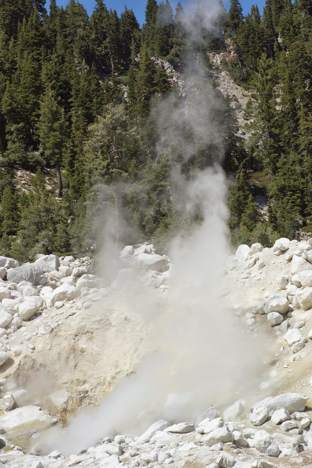
Sulfur and steam: the life signs of a seething volcano.
Named after an unfortunate cowboy who lost his leg after breaking through the thin crust of earth that covered the hot pool in the 1860's, Bumpass Hell is the largest of the geothermal areas within Lassen Volcanic NP. While not as big and spectacular as Yellowstone, Bumpass Hell is quite an impressive reminder that the Lassen area is alive with volcanic activity, seething underneath our feet.


My photos really don't do justice to this place. And there's no way to share online that odor either ...
Sulfur crystals
Precipitation water seeps through the rock. As it nears the magma it boils and steams right back out in hot, smelly and ghostly-looking fumaroles.

This perennial heat nurtures a beautiful palette of greens. I would love to see this place during winter. I don't know how feasible that is.
It is really a unique place. There really is no substitute to taking the time to go down there and experience the volcano at first hand. The sights, the smells, the bubbling sounds, and the goosebumps on the skin.

 As I mentioned, Bumpass Hell is a 'must see' spot and as such, there were quite a few visitors there. I'm sorry to say that not all of them knew that feeding wild animals is harmful and therefore unlawful.
Wild animals can get habituated on human food, which isn't good for them (come to think of it, most of that 'food' isn't very good for people either). They lose their natural fear of people and can easily become victims to vandals. Just as easily they can turn on the hand that feeds them and bite it, causing injury and possibly spreading disease.
In short, do not feed wild animals, no matter how cute they are and what poses they do to get it, and pack out all your trash to protect the wild animals and the environment in which they live and which we all admire and want to enjoy for years to come.
A squirrel fed by human visitors at Bumpass Hell
We took our time at Bumpass Hell but eventually it was time to move on. We crossed the little creek and continued east.
Reading Peak masquerading as Hat Mountain :-)
There is a small hill to ascend when going out of Bumpass Hell eastward. After that, the trail is all downhill. It was there that the alpine spring really blew me away.
Pussy Paws (Calyptridium umbellatum)
 Some flowers there I was well familiar with. In the low lands they were already done with blooming, but up in the high lands spring was at its prime.
Western Houndstongue (Cynoglossum grande)
The trail treads on a hillside, slowly descending towards the valley. For a while, though, we were quite high above, getting glimpses of great view of the meadow and lake below.
Crumbaugh Lake
The hillside itself was brilliant green. The trail was easier than what I remembered (perhaps it was not having to carry a toddler on my back), and I enjoyed the fresh mountain air and the warm sun.  

Stopping for frequent photo-taking, I soon found myself lingering behind the group.
All the better. That way I could pay closer attention to the cracks between the rocks,
Little-Flower Penstemon (Penstemon procerus)
 underneath the rocks,
Mountain Hollyfern (Polystichum scopulinum)
 ... and around them.
Castilleja minimata (Scarlet Indian Paintbrush)
Some of the flowers drew me in for a closer look.
Bleeding Heart (Dicentra formosa)
The rocks themselves were pretty nice,

especially as colorful rock gardens.

As we continued down the trail the trees separated and Crumbough Lake came into full view. It looked very inviting but we save that trail for another visit to Lassen Volcanic NP.
Crumbaugh Lake
The trail holds a steady downgrade and for a good segment is clear of trees. The exposed grassland is full of colorful bloom.
Eriogonum sp.
Two thirds of the way we found a convenient resting spot under some protruding rocks.
We ate and rested and ate some more. The camera didn't rest.
Mountain Mule Ear (Wyethia mollis)
Time was going by and we got up and continued our hike down. Once again, I lingered behind.
Fleabane, Erigeron sp. (glacialis?)
For a short segment the trail sinks into the woods. I was mesmerized by the shadow play of the trunks. It reminded me of a certain painting of Magritte.
A path in the woods
Some nice surprises awaited me when I emerged from the wood. A pretty mariposa lily for one.
Calochortus leichtinii (Leichtin's Mariposa Lily)
And lupines are always a pleasure for me to see.
Bigleaf Lupine (Lupinus latifolius)
Turned out I remembered correctly: the trail was muddy in some places, which made steady walking a bit of a struggle, even without wearing a child. But a wetland, any wetland, is always a great place to look for interesting flowers.
Howell's Marsh Marigold (Caltha leptosepala ssp. Howellii)
That wet trail segment, almost down at the valley floor, proved the most exciting, flower-wise.
Elephanthead Lousewort (Pedicularis groenlandica)
And what can be more exciting than encountering a wild orchid?
Piperia transversa (Royal Rein Orchid)
Easy answer: a patch of wild orchids :-)
Piperia transversa (Royal Rein Orchid)
One more acceptable answer: another species of wild orchid!
Sierra Bog Orchid (Platanthera dilatata)
Orchids are royal, even if they look somewhat drab next to more colorful blossoms.
Aconitum columbianum (Columbian Monkshood)
At the valley floor, nearly 1300 feet below where we started, the trail plunges into the woods again, and becomes guarded by clouds of mosquitoes. It might be a good idea to use the bug repellent ahead of time, because the little bugs managed to draw quite a bit of blood during the few seconds it took me to cover myself with deet.

There on the valley floor I met some of the higher elevation plants
Pussy Paws (Calyptridium umbellatum)
and others that I didn't yet see.
Cobwebby Indian Paintbrush (Castilleja arachnoidea)
In a clearing there is a lush meadow, and nestled in the grass is a small, apparently tranquil lake. That's Cold-Boiling Lake.
Cold Boiling Lake
The apparent tranquility is misleading. Volcanic gas is seeping out from underneath the lake and is bubbling through the water. Another reminder that we were walking on active volcanic earth.
Cold Boiling
The hour was getting late, and the mosquitoes got more and more brazen, so we hurried along the dry dirt path towards the Kings Creek picnic area, where Papa Quail and my brother-in-law drove off to pick up the car we left at Lake Helen, while my sister and I and the children had a relaxing picnic and explored the meadow and the creek.
Kings Creek
This hike is about 4.5 miles, and from Lake Helen to Kings Creek is nearly all downhill. It can be done in the other direction too, of course. The elevation difference is almost 1300 feet, and we took our time getting all the way down. It was a lovely hike, intense with sights and experiences, and I totally recommend this trail to anyone who wishes to experience Lassen Volcanic for more than just a 'drive through' day.


Many thanks to members of the California Native Plants Society for their help in identifying plants!