
 |
| Snag Lake |
Date: July 27, 2023
Place: Lassen Volcanic National Park, Old Station, California
Coordinates: 40.563795, -121.302279
Place: Lassen Volcanic National Park, Old Station, California
Coordinates: 40.563795, -121.302279
Length: 14.5 miles
Level: strenuous
Every summer BC (Before COVID) I used to take my hiking family group on a 4 days camping trip to Lassen Volcanic National Park. I wanted to renew that tradition this year, but the group didn't come together this summer. I decided that I'm not giving up on my annual trip to my favorite National Park in California, so I went there on my own. I reserved myself a single camp site in the Butte Lake campground, and arrived there on Wednesday evening, with just enough daylight left to pitch my tent and to cook dinner.
The next morning I woke up early. The hike I planned for that day was, on the map, about 12 miles. I wasn't in top shape and I knew I would walk slowly and I wanted to give myself as much time as I could for this hike.
As I walked awy from the campground toward the trailhead I saw a woodpecker checking out a nearby pine tree. it's nice to open a hike with a neat wildlife sighting like this.
 |
| White-headed Woodpecker, male |
The trail I planned started at the Butte Lake swim area. At 7 am no other human was at the lake and the water was calm, save for the light ripples that moved gently toward the shore.
 |
| Butte Lake |
The trailhead I started at was the Cinder Cone Trailhead. In fact, The firs mile and a half are on the Cinder Cone Trail. I was very familiar with this part of the trail and I expected to walk it quickly, not taking too many phots, because I've been on this trail many, many times.
 |
| Cinder Cone Trail |
But when wildlife pose itself in front of me, I cannot resist, even if it's a very common bird, such as the yellow-rumped warbler.
 |
| Yellow-rumped Warbler, Audubon variety |
Tiny, star-like flowers decorated the pine forest floor. These little flowers were incredibly difficult to photograph, and I spent a few long minutes trying to do that, with barely acceptable results.

The area of Butte Lake and south is has good coverage of pine forest, populated by at least 4, possibly more, species of pines. In most of the area adjacent to Butte Lake the forest is still intact, having survived the huge Dixie Fire of 2021. Movement on one of these trees caught my attention - it was two little chipmunks interacting with each other up and down the tree. These were lodgepole chipmunks. Lodgepole pines are probably the most common pine species there.
 |
| Lodgepole Chipmunks |
The trail I planned to hike was a large loop trail surrounding Butte Lake, Cinder Cone, the Fantastic Lava Beds and Snag Lake. I have hiked this loop before with Pappa Quail about 20 years ago when it was just the two of us. What I remember from that hike I'll share in bits throughout this post. One of the things we did on that hike 20 years ago was to go up Cinder Cone. It was our second time going up Cinder Cone and the first time we had descended from its south side.
 |
| Cinder Cone |
This time I decided to pass on ascending Cinder Cone. I've gone up this most beautiful little volcano more times than I can remember in the last 20 some years. the last time being last year with my sister. Come to think of it, I might write a new blog post about the Cinder Cone hike, because the posted one is pretty old. As I passed the trail junction I saw a sole hiker descending from the cone, striding down in half jumps to the bottom. I waved to my favorite volcano and continued on the trail bypassing it in the west.
 |
| Cinder Cone-Snag Lake Trail |
Out in the open bloomed more wildflowers, nearly all of them buckwheat, two or three species of buckwheat.
 |
| Naked Buckwheat, Eriogonum nudum |
The field west of Cinder Cone is strewn with large basalt stones that fell from the cone when it erupted, about 300-400 years go. The trail went right between the large stones and the area flanking it looked like a field of huge, black pumpkins.
 |
| Cinder Cone-Snag Lake Trail |
One of the formations that are best seen from the top of Cinder Cone are
the Painted Dunes. I wasn't going up Cinder Cone that day, but there
area some painted dunes south of it, and the trail went very near them. In fact, the trail that comes down the cone from the south side goes between these dunes. I was very saddened to see the foot prints of people who chose to climb the dune faces. This defacing of their beauty is sacrilegious. And the damage can last a very long time.
 |
| Painted Dunes |
The painted dunes are not true dunes. They are part of the Fantastic Lava Beds that were coated by the hot volcanic ash of the final eruption stage. The heat and exposure to the air caused the metallic elements in the ash to oxidize and create the beautiful colorful display that gave these hills their name. As I passed the painted dunes I paid attention also he to colorful flowers that bloomed near the trail, well dispersed in the arid terrain. Butterflies were also giving them attention, and for a tastier reward.

I barely cleared the painted dunes when I noticed the snow peak peeking over on the southwest - Lassen Peak looked gorgeous between the black volcanic earth and the bright, blue sky. I had plans to get much closer to it on the morrow, but there was one more hike I wanted to do in the Butte Lake area besides the one I was on at the moment.
 |
| Lassen peak |
Ahead of me loomed another volcano - Fairfield Peak. I thought I saw a trail leading to it when I checked my map earlier. I wasn't about to hike there today, but it would be nice to go there on another visit to the park.
 |
| Snag Lake Trail |
The seem between the Fantastic Lava Beds and the flatter earth below seemed to be a little more supportive of plant life, possibly because of the water runoff from the lava beds.
 |
| Shasta Penstemon, Penstemon heterodoxus |
I was walking for about an hour and it was morning still, but the day was already getting hot. I saw a fallen log by the trail, a log that wasn't all charred by fire, and decided that it would be a good place to stop for a drink of water. The log itself was very pretty, with all the twists and the knots of the exposed wood. A lizard was also sunning itself on it, but it escaped before I could take its photo.

Perhaps the most common wildflower along that part of the trail was the sulphur buckwheat (yes, that's the correct spelling). The little cushions of intense yellow stood in strong contrast to the black cinders of the local terrain.
 |
| Sulphur Buckwheat, Eriogonum umbellatum |
The trail dipped into a flat area that looked greener than all of its surrounding. It must have retained moisture longer than the flanking area. Perhaps that was the place of the last snow before it melted.

As might be expected, there were different wildflower species blooming in that area where the moisture lingered longer.
 |
| Rocky Mountain Groundsel, Packera streptanthifolia |
The trail continued on the west side of the Fantastic Lava Beds. These lava beds came out of that small, perfect volcano, the Cinder Cone. The lava cut off the flow of Butte Creek, forcing the water to collect into two lakes - Butte Lake, where I started my hike, and Snag Lake, where I was now headed.
 |
| Butte Lake-Snag Lake Trail |
I turned around and looked at the back view of Cinder Cone. I felt a bit remorseful for not ascending it this time. As it turned out, that was a smart decision, because at the end of the loop I came upon an obstacle that forced me to add nearly two more miles to my hike to bypass safely.
 |
| Cinder Cone, view north |
Besides the buckwheat, the volcanic cinders ground supported also sparse - growing pussypaws. Most of them were already done blooming but I did find a few straggling individuals.
 |
| One-seeded Pussypaws, Calyptridium monospermum |
nearly all the trees I saw along the hike were pine trees. Of those, they were mostly of the lodgepole pine species. The pines that weren't affected by the fires seemed healthy and looked beautiful.
 |
| Pinus contorta |
What was just as beautiful were areas of the Fantastic Lava Beds that differed from the standard black basalt piles. in some places the rock was colorful, usually in reds and blues.
 |
| Fantastic Lava Beds |
In places the rocks were covered by colorful cinders, like in the Painted Dunes, only not as exquisite, at least not on a side view.
 |
| Fantastic Lava Beds |
The day was bright and sunny. There was not a single cloud in the deep blue sky. There was however, something white and fluffy floating right above me - a seed parachute without the seed. I watched it move gently through the air, and eventually remembered to take a photo before it floated away into infinity.

Another thing moved through the air near me. This one was moving fast and with intention - a dragonfly. It settled briefly on a bare twig of a gooseberry bush, then flew away.

I resumed my hike. The trail moved in and out of the pine forest. The trees were far enough apart to allow a lot of sunshine through. The hour was early still so the shade of the thin pines stretched long enough to allow some relief from the heat.
 |
| Butte Lake-Snag Lake Trail |
Every now and then the trail dipped closer to the Fantastic Lava Beds, allowing me a closer look at the impregnable wall of black rocks. I sure at some point in time there were people crossing the lava field, perhaps in search of refuge, perhaps in exploration. I remained on the trail.

There are conflicting opinions as to when the Cinder Cone erupted. I think the current thought is that it occurred between 300-400 years ago, meaning there were human eye witnesses of the event for sure. It takes a long time for the land to recover from a volcanic event in this high, and relatively arid area. There were very few trees growing on the lava beds, and they looked small, although they were probably older than they appeared.
 |
| Fantastic Lava Beds |
Members of the California Geology Forum suggested that these colorful rocks are in fact, fragments of the ancestral Cinder Cone that were dislodged and swept away by the lava flow. That is very cool indeed!
 |
| Fantastic Lava Beds |
I was admiring the Fantastic Lava Beds but knocks to the right of the trail pulled my attention - at the base of one of the trees there, a hairy woodpecker was busy searching the tree for morsels.
 |
| Hairy Woodpecker |
I was aware that the Dixie Fire of 2021 had caused much damage in this area. West of the trail and of Snag Lake though, the fire damage was much older, and the forest was already recovering. I walked through large areas with a few standing dead trees and many, many young, and very healthy looking pines growing vigorously.

The trail was mostly flat with only minor undulations up and down. I was getting hot and started thinking of a break when from a high spot on the trail I saw Snag Lake far below and my heart jumped.
 |
| Butte Lake-Snag Lake Trail |
Across Snag Lake was a volcano, one of many within Lassen Volcanic National Park. On the side of this volcano, Mt. Hoffman, I notice a white and sparkly spot. Could that have been a leftover snow patch?
 |
| Is that snow? |
I hopped and trotted down the cinders trail to Snag Lake, slowing down only for the little, pink wildflowers that bloomed under the pine trees. These were wirelettuce, and there were many of them around.
 |
| Large-flowered Wirelettuce, Stephanomeria lactucina |
I paused also to try and capture a beautiful dragonfly that stopped to rest on the trail right before me. The background hid it almost completely, it is better to open the photo to see the dragonfly.


Snag Lake lay before me, beautiful blue between the black lava beds and the quiet pine forest. There was no other human soul there. In fact, from the moment I left Cinder Cone behind me I saw no other human on my hike until I was back in the north side of Butte Lake.
 |
| Snag Lake |
I reached Snag Lake and stopped in the tree shade for a short break to hydrate both my body and my soul. Now that I emerged from the protection of the lava beds wall I could feel the breeze caressing my face. The wind was strong enough to raise little waves in the lake.
 |
| Snag Lake |
Because of the massive precipitation that Lassen Park got this past winter I expected to see the lake full to the brim, and I was surprised that that wasn't the case. What really caught my attention were the strong water marks on the rocks and the trees up the shore. These marks indicates not only that the lake levels were this high at some point, but also that the high water marks changed in distinct steps and not in a continuous manner.
 |
| Water Marks |
There were small groups of aspen growing in the water. Their trunks also had the high water marks, which looked like barcodes. Just scan and go.
 |
| Water Marks |
I moved to a more open area along the lake shore and scanned the lake's surface for waterfowl. There were no birds in the lake but I enjoyed seeing the sunlight playing with the little waves.Mt. Hoffman loomed over the southeast shore. I could also see the giant scar that the Dixie Fire left in the forest below.
 |
| Snag Lake |
The trail continued south along the west shore of Snag Lake. One of the things I remember vividly from my hike here twenty years ago was all the fallen logs that blocked the trail. We were warned at the time by a park ranger that a recent storm dropped a lot of trees and the the trails weren't cleared yet. We chanced it anyway, and indeed we had to go around or hop over many, many fallen logs. I kept expecting to have to bypass fallen trees but I didn't have to at all - the fallen trees were pushed to the side or cut, and the trail was all clear and well maintained.
 |
| Snag Lake Trail |
I passed a few gooseberry bushes along the way. They were already in the fruiting stage, but the fruit not yet ripe. No snacking here, then.
 |
| Gooseberry, Ribes sp. |
Little lizards were sunning themselves along the trail. Most were too quick for me and darted off before I could photograph them. This one paused between the bushes long enough for me to react. Maybe that's how it lost its original tail in the first place.
 |
| Western fence Lizard |
The time moved along with my hike. It was getting close to lunchtime and I was getting hungry and started thinking of having a lunch break soon. I wanted to stop at a nice place near the lake but stopping on the west shore would be just a bit too soon. I looked ahead and saw a lovely little peninsula jutting into the lake were nice, healthy looking trees were growing and casting a welcoming shade. It would have been a lovely place to stop, but after consulting the map I realized that the trail goes too far from that peninsula. In fact, if I wanted to stop by the lake, yet not too soon, I would have to make it all the way to the east shore where the traile nears the lake again. Oh well.

I decided that so it would be. I'd walk all the way to the east shore before lunch, unless I find a nice place to stop before then. One of the things I knew for sure that I'd want would be shade. It was already quite hot and I was hopping from one tree to another, attempting to minimize my exposure to the direct sun. At times that was difficult because the old fires had killed the older trees in large areas. It was nice to see the vigorous recovery though.
 |
| Old survivor and new growing pine trees. |
Pines were the dominant trees all around but the aspens had their own little dominions here and there, especially near the lake or by the side creeks. The breeze made the aspens quake in the loveliest sparkle dance.

In the water were some plants too - a patch of green rushes just off shore.

Nearing the south end of Snag Lake I was now walking entirely in the open. I wanted to go quickly but there were too many things to see along that part of the trail, including many wildflower species.
 |
| Snag Lake Trail |
Along the west shore of Snag Lake is also where I started seeing the
mountain monardella, and I was glad to see they were at peak bloom. I
resisted the temptation to pick some for my evening tea. The butterfly didn't need to resist anything, it simply indulged itself.
 |
| Mountain Monardella, Monardella odoratissima |
Besides butterflies, there were also many dragonflies in the air. They weren't interested in the flowers although they did fancy some stems as convenient perches.
 |
| Dragonfly |
A plant that I often see in other places but usually not so much in Lassen Volcanic NP is the pearly everlasting - named this way because the dry inflorescence looks like it is still a fresh bloom.
 |
| Pearly Everlasting. Anaphalis margaritacea |
I came across a little side brook, one of several I crossed on this hike. It was a good place to wash my hands and face for freshening up. It was also a great place to see more wildflowers, of species that grow in wetter places.

The cinquefoil is a common genus I see on my hikes. This gens has many species, and I couldn't identify the species of this one.
 |
| Cinquefoil, Potentilla sp. |
There are also many, many species of monkeyflowers, and I saw at least three different species on my hike that day.
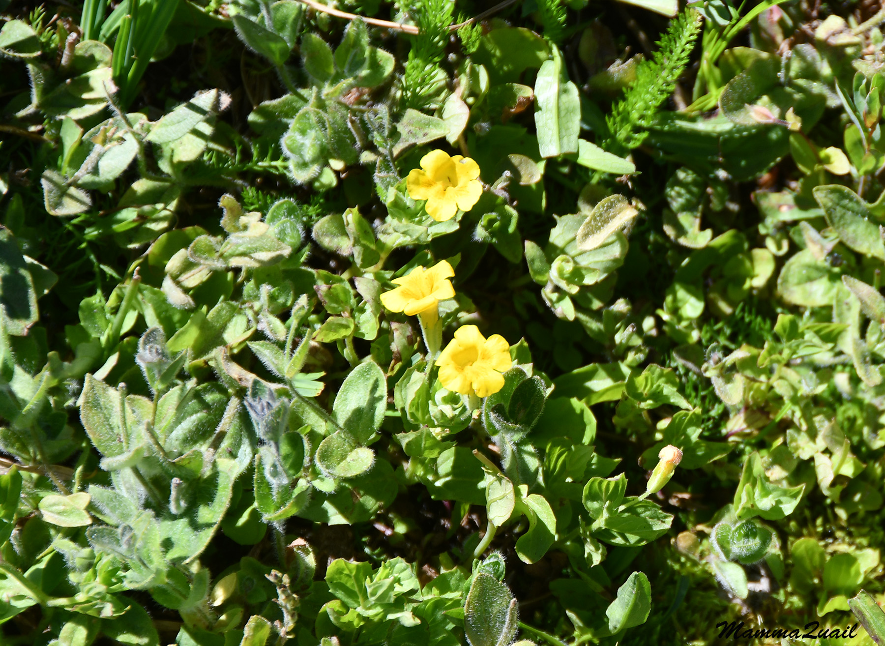 |
| Musk Monkeyflower, Erythranthe moschata |
My most exciting find however, was one of the smallest flowering plants I saw on that hike - the dwarf chamaesaracha. It's a tiny solanaceous with flowers that bloom underneath the leaves and are pointing downward, like bells. This is what is called in the botanist jargon, a 'belly plant'. Indeed, I had to go on my belly in order to take this photo.
 |
| Dwarf Chamaesaracha, Chamaesaracha nana |
Unlike the wildflowers which were plentiful and diverse, most wildlife remained hidden from my eyes or run away as soon as I lifted my camera. Even the ants, which usually ignore me, wouldn't pose.
 |
| Harvest Ant |
The shadows were shifting and getting shorter. It was almost mid day and I still didn't fid an idea place for a lunch break. I knew that soon the trail would distance from the lake so I tried increasing my pace.
 |
| Snag Lake and Mt. Hoffman |
I didn't walk fast for very long though. There were just too many beautiful flowers all around me. I think at that time I already knew I'd be splitting this hike into two blogposts. I was seeing and experiencing so much on this hike, and it was a very long one.
 |
| Sierra Arnica, Arnica nevadensis |
The penstemons I've been seeing for some tome along the west shore of Snag Lake, but the more south I got, the more of them I saw, and more intense in color they were.
 |
| Slender Beardtongue, Penstemon gracilentus |
Indeed, soon the trail started distancing from the lake. There were many old fallen logs in that area, many of them charred. I remembered having to climb or hop over fallen logs on my hike there, twenty years ago. I was very glad that I didn't have to do any of this now, since my leg has been bothering my for some time.


It seemed that my lunch break won't be happening very soon. I decided to sit down somewhere for a few minutes to rest and drink, and maybe snack a little bit. I found a fallen log between numerous yellow-blooming rabbitbrush shrubs and sat down.
 |
| Rabbitbrush, Ericameria sp. |
I took a few sips and pulled some nuts from my trail mix bag when I noticed a squirrel running on top another log across the trail. This was a female golden-mantled ground squirrel. She was pregnant and was holding nesting material in her mouth. She kept looking at me but didn't run away to hide. Eventually she climbed a standing dead branch and sat there, gazing at me intensely. At first I thought that she wanted to share my snack but she didn't behave like any other begging squirrel that I've seen before. Eventually my penny dropped and I realized that I was probably sitting exactly where she was fixing her nest ... I apologized, collected my things and resumed my hike down the trail.
 |
| Golden-mantled Ground Squirrel |
Away from the lake the vegetation changed greatly. Now the forest floor (yes, I was back in the forest) was dominated by small, knee-high shrubs. I photographed one of them that looked unusually pale, ghost like.

Here and there were patches of wildflowers. Some of them looked like common weeds from my yard but I had not the knowledge to know. The yellow composites can be challenging to identify.
 |
| DYC |
I saw surprisingly few Indian paintbrush plants on this hike. I don't know if that was because they were having a less than optimal year, or that this was simply or their best habitat. The paintbrush plants I did see seemed small and lonely.
 |
| Paintbrush, Castilleja sp. |
Another genus I haven't seen much of on this hike was the Silene, or campion. I think I saw only this one plant, and even this was nearing the end of its bloom.
 |
| Douglas' Campion, Silene douglasii |
Starting to make the curve around the south shore of Snag Lake, I was also entering the Dixie Fire impacted area. This wasn't the hardest burned part of the forest - many of the burnt trees were still alive, their canopies green over charred trunks.
The ground too was greatly affected. Just under two years since the fire, most of the forest undergrowth consisted of annuals and small shrubs. It was there that i saw one other species of monkeyflower, and there were many of them in that one spot.
 |
| Torrey's Monkeyflower, Diplacus torreyi |
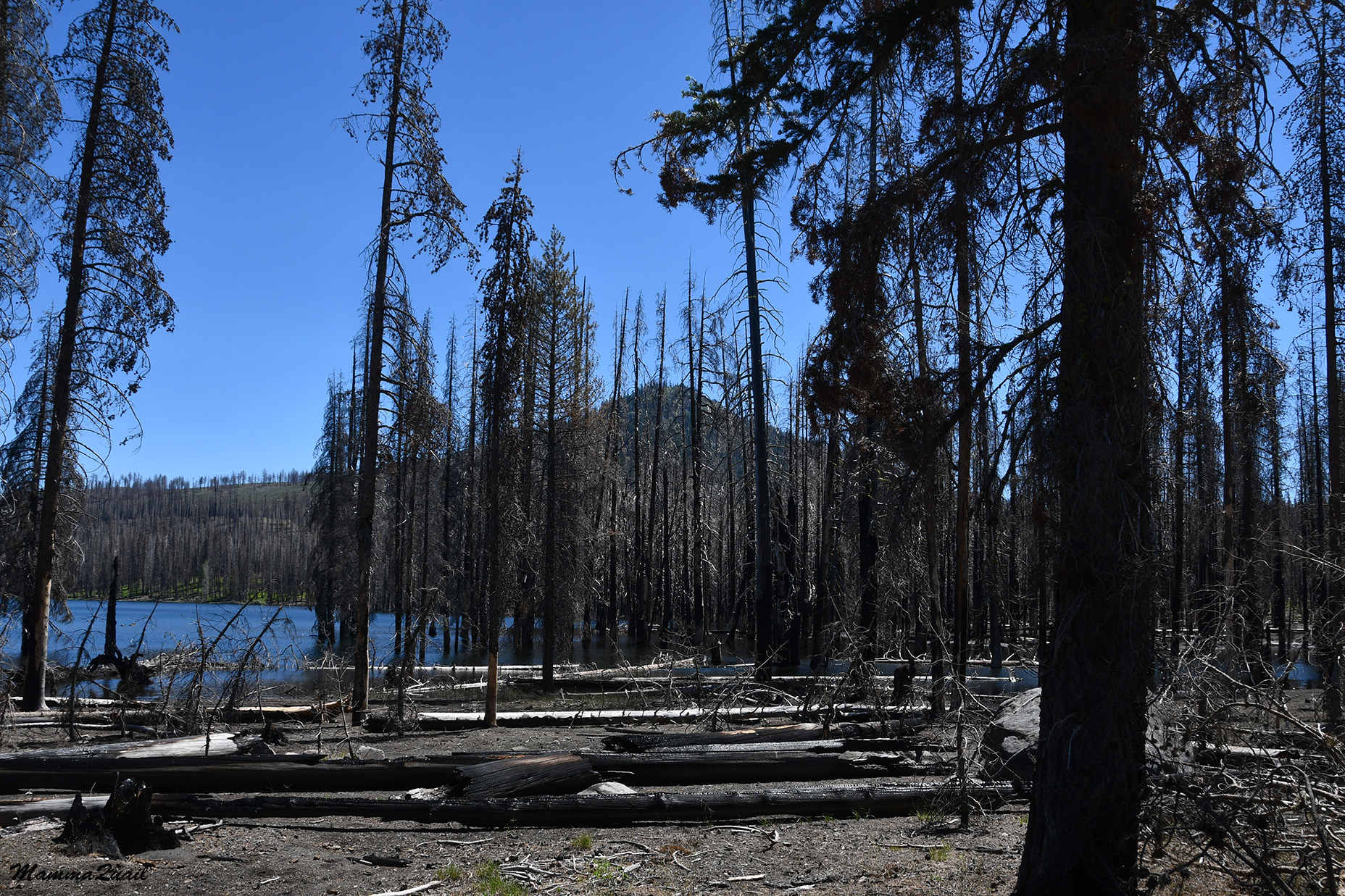
A bit further down the trail I was already in the area that was impacted much harder by the fire. The forest was completely burnt above ground. All the trees were dead, and I was walking through a forest of charred, upright tree corpses. I kept my eyes down where a much happier scene spread before me - that of colorful wildflowers that were going crazy now that the trees were no longer shading them.
 |
| Snag Lake Trail |
here and there were areas that were greener and had some different vegetation. It could be that moisture was retained longer in those spots.
 |
| Anderson's Thistle, Cirsium andersonii |
The dead forest thickened. The smell that came to my nose with each step was the minty fragrance of the monardella - the most dominant undergrowth wildflower of that burnt forest. Co-dominant with it was the slender penstemon. The entire forest floor was white and blue with these two species blooming together.

These weren't the only ones though. Between the penstemon and monardella bloomed a few other wildflower species.
 |
| Productive Clover, Trifolium productum |
Some of these plant species I would see in huge numbers on the east side of Snag Lake, later on the hike.
 |
| Large Mountain Monkeyflower, Erythranthe tillingii |

This trail isn't heavily used and without close attention it would have been easy to miss any trail junctions, especially in places where the vegetation cover was low. I was glad therefore, when I came upon the sign marking the trail junction marking where I should turn. Going on straight south I would reach Juniper Lake, and area that was very beautiful a few years ago when i camped there with my family, and was now closed still, off limits because of the Dixie Fire damage.

I turned east, fallowing the trail that would bring me to Snag Lake's eastern shore and eventually back to Butte Lake. With the change in directions, I also started seeing different plants.
 |
| Tidy Lupine, Lupinus lepidus |
The penstemon was now getting augmented by other blue-flowering plants such as the lupine above and the aster below. I found neither of them in large numbers, however.
 |
| Hoary Aster, Dieteria canescens |
I was getting tired and really needed that lunch break i started thinking about over an hour ago. I increased my pace again in hope of reaching Snag Lake's eastern shore soon. On my map was marked a creek crossing on my way, but I haven't paid it much consideration. Most creeks I crossed so far were either dry or barely flowing.
 |
| Spreading Phlox, Phlox diffusa |
I was therefore, very surprised when I came upon that creek and found out that there would be no crossing of it without wetting my feet. I wasn't prepared for creek fording, having left my sandals at the campground.
 |
| Grass Creek |
I sighed because I knew I'd have to cross barefoot and the rocks that made the creek bed were not smooth pebbles at all. What made me very happy though, were the lilies that bloomed near the water.
 |
| Leopard Lily, Lilium pardalinum |
I sat down by the creek, removed my shoes and socks and folded my pants up. Hanging the shoes on my neck I carefully waded across. the water was cold and the sharp rocks hurt my feet. I walked very slowly to the remains of what used to be a bridge a flood or so ago. I sat down on that bit of bridge and as I wiped my feet dry and put my shoes on again I thought that this would actually make a very nice lunch break spot and that I don't need to hurry to get to the lake's east shore. My mod improved at once as I opened my backpack and puled my food bag out.