Date: March 10, 2020
Place: Black Diamond Mines, Somersville, California
Coordinates:
Length: about 5.5 miles
Level: moderate
For several years now, Black Diamond Mines Regional Park has been on my top wanna go there list. I even went there a few times before, but for various reasons I did very little hiking on those occasions. Eventually I figured out that if I wanted to truly hike at this place I needed to put it on my chikas' 4H Hiking Project list, and this year I finally did. As our 4H March hike date approached I needed to go there and do a scouting hike to check out a suitable trail. Escaping the onslaught of news about the spread of the COVID-19 coronavirus I went to Black Diamond Mines for the perfect nature escape.
 |
| At the Nortonville trailhead |
I stopped first at the visitor center to ask for trail recommendation and a nice park ranger highlighted a few options for me on the map. Following his top suggestion I drove all the way up the road to the Somersville parking area. From there I started down the paved path leading to the Greathouse Visitor Center (which was closed to the public), then made a right turn onto Nortonville Road to begin a five- miles loop hike.
 |
| My hike as captured by my GPS. I remembered to turn it off about half a mile down the road after I finished the hike. |
Black Diamond Mines was an area of coal mining that supported several communities, Somersville where I begun my hike (and that since the time of coal mining has moved closer to Antioch) and Nortonville (which no longer exists) were two such communities. The trail I begun my hike on was the road connecting these two communities.
Somersville and Nortonville shared some institutions, and one of the was the local cemetery, up the hill between the two towns. The cemetery is noticeable up and to the right of the big tree in the photo below, marked by the dark European cypress trees.
 |
| The hills east of Nortonville Road |
Some distance up the hill I turned and looked at the view east, to the lovely green valley I was now climbing out of.
I took the small detour to visit the Rose Hill historic cemetery. Information about the cemetery and the people buried there is posted on signs at the cemetery's gate. Throughout the years since the local communities moved away this cemetery fell into disrepair and vandalism, until the area became a park. It is now maintained and preserved. Many of the headstones have beautiful carvings and there is information about some of the people buried there. Apparently many of them died of smallpox. The Covid-19 was already a looming threat on the day of my hike. Looking at the young smallpox victims' graves does put some perspective on things.
Another interesting anecdote is that I didn't see in this cemetery and crosses - apparently that wasn't the custom of that community at that time.
 |
| Rose Hill Cemetery |
I exited the cemetery on the other side and rejoined the Norton Rd trail, going uphill (header photo).
Little orange flowers dotted the grass alongside the trail. These were fiddleneck plants at the beginning of their bloom season.
 |
| Fiddleneck, Amsinckia sp. |
The view west from the high point of Nortonville Rd Trail wasn't much different from the view east into the valley of Somersville, except for the high power lines stretching along the gulch and disappearing somewhere in the north. I took a good look around then begun descending down the trail toward the site where Nortonville used to be.
 |
| Nortonville Road Trail |
I passed by a small grove of live oak trees near the trail. One of them had a very different shade of green than the others - it was a bright light green color standing out of the dark green background of the live oak foliage.
I approached the tree to take a closer look. The color, it turned out, was the tree's bloom.
 |
| Interior Live Oak, Quercus wislizeni |
Of the town of Nortonville nothing remains, but there are plenty of leftovers of the coal mining site there, mainly minds of debris, like scars in the otherwise pastoral scenery.
 |
| Nortonsville |
At the Nortonville site I turned left onto Coal Canyon Road. Soon after that I passed a right turn to Black Diamond Road. That road was going straight into a mining site, passing through a large conglomerate of colorful rock. Although I didn't plan to take that trail I felt compelled to g and take a closer look.
 |
| Black Diamond Road |
I don't know if this conglomerate was the mined rock or something that was formed from the mining waste. I think the latter because it was quite evident that this rock was treated with intense heat.
 |
| Coal-the black diamond |
I continued on Coal Canyon Road but then I went on another short detour to check out a side dead-end trail leading south into a deep dark canyon.
At some point that trail may have led to another mining site - there were a few relics where the trail ended. The best part about this side trail however, were the gorgeous buckeye trees that enclosed the path in a brilliant green tunnel of their spring foliage.
The green carpet under the canopy was dotted with hundreds of little white stars - the blossom of miner's lettuce.
 |
| Miner's Lettuce, Claytonia perfoliata |
After a quick look at tat dead-end tunnel of buckeye I resumed my hike up Coal Canyon Rod until I reached the end of the dirt road. From there, continued a narrow foot trail up and into a narrow canyon filled with thick vegetation.
 |
| Coal Canyon |
The cocky walls of the canyon were made of hard sandstone, and to my right gaped a man-carved cave. I went in there and found out that it was short and full of carved graffiti.It might have been part of the sand quarrying that took place in the area after coal mining was discontinued.
I started up the narrow trail and soon started seeing wildflowers. The ranger who recommended me this trail had said that spring bloom was only beginning and indeed, it was the first wave of spring bloom that had welcomed me up Coal Canyon.
 |
| California Man-root, Marah fabacea |
A large committee of vultures circled above my head, gliding up on a thermal. I was mesmerized by the graceful motion of these large birds circling in the air.
 |
| A thermal of turkey vultures |
Initially the trail up the canyon rises steeply along the western slope. After a short and steep climb it levels a bit and plunges into thick vegetation. Before entering the shade I paused and looked back to the Nortonville valley.
It was a sunny day but the air was cool. Still, I welcomed the nice shade cast on the trail by the many oak trees that wrapped the canyon in their canopies.
The canyon was beautiful and the vegetation pretty, but most interesting was the colorful earth, alternating between white sandstone, red chert and black coal deposits.
The coal has been mined there, for sure. Part of the trail traversed a slope of fine black sand that was discarded from a mining site upslope.
 |
| Coal Trail |
A little higher up the trail leveled off again and the mining scars disappeared as lush spring vegetation competed the ground cover.
Deep in the shade bloomed the early spring canyon flowers. My heart skipped a bit when seeing for the first time this spring the magnificent Indian warrior.
 |
| Indian Warrior, Pedicularis densiflora |
Next to the Indian warrior bloomed the modest canyon nemophila, like little pearls nested on the green and brown canyon slope.
 |
| Canyon Nemophila, Nemophila heterophylla |
And to add some more color: the delicate shootingstar.
 |
| Padre's Shooting Star: primula clevelandii |
Higher up the canyon the trail steepened once more and the flora changed from the dark and shady oaks and buckeye to the drier and thinner-foliaged manzanita and Coulter pines.
 |
| Manzanita, Arctostaphylos sp. |
The wildflowers changed as well, with the blue witch bushes showing almist full bloom, but still before their peak.
 |
| Blue Witch, Solanum umbelliferum |
The oaks were different higher too - instead of the evergreen live oaks I was seeing deciduous oaks now. These oaks were just beginning to bud out.
Near the end of Coak Canyon trail there is a mark on the map labeled: "Jim's Place". When I arrived there I found Jim's Place to be a primitive dwelling dug in the sandstone.
 |
| Jim's Place |
The information in the park's brochure has it that it is not known who dug this shelter and who used it. Nor who was this "Jim" after whom this place was named.
 |
| Jim's Place |
Coal Canyon Trail ends at the ridge where it meets Black Diamond Way which is a paved road, no longer in use by vehicles. Before continuing on that road I peeked over the ridge at the Carquinez Straits to the north.
 |
| View north at the Carquinez Straits |
Given more time I would have stopped there for a break but needed to be back home on time to pick up the chikas from school so I moved on right away, turning left (south) on Black Diamond Way.
 |
| Black Diamond Way |
Along black Diamond Way grew thickly an old acquaintance - the infamous poison oak. It is actually a very pretty plant and a very important food source for wildlife in the area.
 |
| Poison Oak, Toxicodendron diversilobum |
The majority of trees up the ridge were oaks but in between them where a few Coulter pines. I love pine trees and especially the graceful Coulters for which the Mt. Diablo area is about their north most grown region.
The pines I saw where at the onset of their bloom, not quite yet shedding pollen but very close to that time.
 |
| Coulter Pine, Pinus coulteri |
The road took me around the curve of the hill in a constant, mild upslope grade. From one f the turns I could see all the way to the quarry at the mouth of Mitchell Canyon, one of my spring bloom pilgrimage sites.
In the far horizon the very tip of Mt. Tamalpais could be seen as well. So far, yet very characteristically recognizable.
 |
| View to Clayton |
The road took a turn to the east and I followed it uphill as the slope steepend. Ever since I turned onto Coal Canyon Rd I've been going uphill, and I already gained much altitude. I knew that when I get to the downhill part it will be steep. It would have to be, because I already passed over two thirds of the loop distance.
 |
| Black Diamond Way |
Black Diamond Way continued up to the hill's summit but a gate with a sign posted "Private" blocked my way. Just before the gate forked north the dirt road that was the continuation of Black Diamond Trail. I paused there briefly to look at the view on the Carquinez Straits, then started downhill on that trail.
 |
| The Carquinez Straits |
The train took me down the north-facing slope which was green and lush but more exposed so not as forested as the Coal Canyon I came up through.
Two little birds fidgeted on the dirt road ahead of me. I did not have a lens suited for birding with me but I did my best to capture a recognizable image of these birds. Indeed it was enough for the birders in my family to identify them from my photos.
 |
| White-brested Nuthatch |
The trail twisted and turned, following the curves of the hills. Most of the hills there are rounded by erosion and have gentle curvature. Here and there however, there were some geological stand-outs like this dinosaur-scale ridge of rocks that I saw lined out on the slope across the creek from where I was walking.
To the northeast of my path bulged a butte that looked very different than the round, grassy-green hills all around. This one has sharper lines and was made of layers of light-colored rock, visible through the deep dark green of a thick live oak forest. The I had showed that my trail would take me closer to that hill. My watch however, told me that I wouldn't have the time to explore it better.
As I approached that dark looking hill hillside I was walking on became less forested and more exposed. Little wildflowers decorated the grassy slopes and as much as I was in a hurry, I did take a moment to stop and enjoy them.
 |
| Owl's Clover, Castilleja densiflora |
It may not have been peak bloom but there were certainly enough flowers to tell that spring was well on its way.
 |
Blue Dicks, Dichelostemma capitatum
|
Eventually I came as close as the trail allowed to that sharp, dark hill I saw from higher up. I was amazed at the sharpness of the borderline between the rocky, oak-forested hilltop to the mild, grassy slope of its base.
As I turned the curve around this hill the view east opened up before me and the vastness of the East Bay hills struck me again with its beauty and richness, and promise of many secret nooks to explore.
 |
| View east |
It was on that part of the trail where my solitude was disrupted as more hikers, some solo but mostly in pairs were coming up the trail and crossing my path. While not yes under shelter-in-place orders, we still practiced the recommended physical distancing and nodded each other across the width of path.
 |
| Silver Bush Lupine, Lupinus albifrons |
Of all the people I saw coming by that way, no one seemed closely interested in the tiny wildflowers that dotted the side f the trail.
 |
| Red Maids, Calandrinia menziesii |
Where there are flowers one can expect to see butterflies too. There weren't many butterflies, and the few that I did see did not cooperate with my camera, save for one little blue butterfly that paused just enough to pose.
 |
| Azure Butterfly |
There were also variants of flowers that I've seen earlier on my hike. Although the same species, they looked different enough to merit a separate photo representation.
 |
| Padre's Shooting Star, Primula clevelandii |
Finally I arrived at the trail intersection I was looking for. The Black Diamond trail dirt road curved to the left. To the right continued the dirt road that would extend my loop to the east, something I considered doing at the beginning when I thought I might have the time. Given my constraints, I took the middle path, a narrow foot trail leading into Manhattan Canyon.
 |
| Manhattan Canyon Trail |
Manhattan Canyon trail started at a mellow downhill slope but as soon as I was in the canyon itself, the grade increased sharply and I was going down fast.
In the shady part f Manhattan Canyon there were many wildflowers growing, but all of them I have seen earlier at Coal Canyon, like the shooting star and the Indian warrior.
 |
| Manhattan Canyon Trail |
At a sunnier spot I saw the woolly paintbrush, familiar to me from many Bay Area hikes, but my first encounter on this hike.
 |
| Woolly Paintbrush, Castilleja foliolosa |
In mid-canyon the trail forked again and I turned right on Chaparral loop which would be the quickest path to the parking area. I was already running late.
Being in a hurry and not as careful as usual, I took a wrong turn and ended off trail and in the creek itself.
The creek bed was dry and it was obvious that other people were walking through it on a regular basis so I continued down that path. On my way I passed by yet another man-carved sandstone tunnel but this time I did go inside to explore.
The canyon was short but I had to go down it carefully because the path involved some rock scrambling and poison oak avoidance. Eventually I came out the bottom and rejoined the main trail. Ahead of me, below the mine waste mounds I could see the Somersville Parking Area.
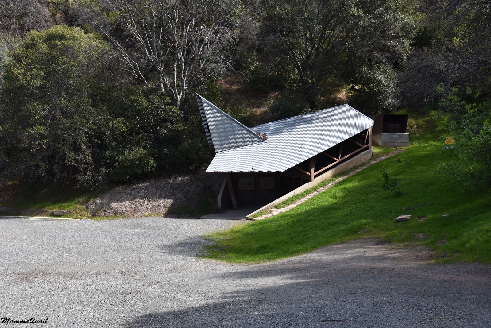
I hurried down the trail past the Eureka Sloe mining tunnel. On summer weekends this would be open to the public.
 |
| Eureka Slope |
The last part of my hike I did in an almost dash, hurrying to the parking area. One final snapshot of a posing sparrow, and I was all but running to my car.
 |
| Lincoln Sparrow |
Needless to say, I was late picking up my chikas and had to listen to their runts all that afternoon. On the other hand, this was my last hike before the shelter in place begun. Just before the order came out however, our 4H Hiking Project did meet there to hike that trail but a rainstorm begun and we turned about at the Rose Hill Cemetery, without completing the beautiful loop I was fortunate to explore on my solo prep hike.
I have much more to explore in that park still. And I will go back there once the Covid-19 danger goes away.