Friday, November 30, 2012

On a different angle - To Mission Peak from Ohlone College

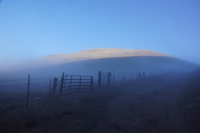
A view to the west from near the summit of Mission Peak.  In bight blue is the sky. Below it in dark blue is the peninsula hills. The light brown is the slope of Mission Peak. Everything in between - Fremont, Silicon Valley, the peninsula cities and the Bay itself- is hiding under a thick layer of fog.  
Place: Mission Peak Regional Preserve, Fremont, California
Trailhead coordinates: 37.5262, -121.9068
Date: October 29, 2012
Difficulty: strenuous

Mission peak is right there, so close to my home. It is only natural that I would ascend it as often as my time allows. I already posted here about my first conquest of the Peak, ascending from Stanford Avenue staging area. This time I took a different trail - the one that begins at Ohlone College. This trail is a bit shorter - less than 6 miles round trip - and is not as steep, but still gives a good work out and, what's more important, a different scenery on the way to the top.


It was a very foggy morning. So foggy, that I found myself wondering about the necessity of my having brought the camera along. To justify the weight of the camera, I looked for near subjects to photograph. 
A spider, hard at work
I am fond of spiders. I find them interesting and beautiful. Also, they are on my side when it comes to dealing with mosquitos and other annoying bugs.
It was less than a week after the first serious rain of the season. Nature's response was quick to sprout:
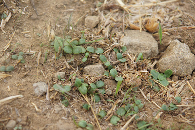
New growth near the trail

At the time of my hike, the spouts were barely visible beneath the dry grass. By now, of course, the hills are green with new growth.
The trail soon entered a groove between tall hills, where the sun was just beginning to send it's rays over the skyline.
I watched the patch of light slowly descending on the hill to my north, where it was diffused by the fog. Although illuminated, I could barely make out the hill top.


The hill to my east looked even more eerie. It felt almost like walking into one of these Halloween movie scenes.

About half a mile later the wide gravel road merged with a paved road and the Peak trail turned right and up along the road and into some woods. When I emerged on the other side of the wooded area I found that I have left the fog behind me.


The bright, sunny day awaited me on the higher elevation. It was gorgeous and warm. With renewed energies I hurried uphill. The scenery along this trail is mostly of open grass land, managed by grazing to control the wild oats and other invasive grasses and so reduce fire danger. I did spot a deer there, but the largest most common mammal there is the Black Angus.
It was calf season, meaning there were many young calfs about. They are so cute, I really cannot imagine turning them into steaks.


Their mammas were there too, of course. On a family hike a couple of years ago in Sunol Regional Wilderness we had encountered an aggressive mother cow that nearly charged us. Ever since I take more care when approaching cattle on the trails, making sure never to walk between a cow and her calf. That is not always easy, because often they stray from one another and are on opposite sides of the trail.
I passed peacefully near the cows and they didn't mind me.
Good.
I made it to the Peak's shoulder and looked to the west. Below me shined the golden grass on the slope of Mission Peak. The dark peninsula hills loomed darkly afar, underneath the bright blue sky.
In between ... the bay and its cities, east and west, were completely hidden under a thick white blanket of fog. It was there that I took the picture that heads this post. I then turned my back to the fog and continued ascending. Soon enough I met my friend the Horned Lark. So far, the high elevation of Mission Peak is the only place where I've seen this bird. But I see it every time I go up there. It is 100% reliable.


Birds were not the only winged beings there this time. Most ants are not winged, of course, but on this hike I came across a nest where the newly metamorphed royalty were going on their matrimonial flight, the only flight in their lives they'll ever take. After mating, the males die and the females loose their wings and dig up a hole where they lay their eggs and become queens of a new nest.

The last part of the ascend is the same one I did before. It is also the steepest part of the climb, and as always, I was both exhausted and elated when I reached the summit.
Below me it was still foggy. I could see a thin apparition of Fremont outskirts just at the bottom of the peak. That red-tailed hawk probably saw more than I.

Red-tailed hawk soaring above the fog
I ate my lunch in leisure. By the time I was done and ready to go back down most of the fog had cleared.


Going down was quick. I made only two short stops - one for a drink of water, and the other to photograph our state flower, a splash of color standing out in the sea of dry grass.
California poppy


* One small note - on this hike I tested a pair of hiking poles. While offering only a mild support on the ascend, they did make a real difference going down. The trail is steep an the poles added significant stability to my gait. I made it down considerably faster than I would have without them.
Sunday, November 25, 2012

Along the waterfront at Point Pinole


Place: Point Pinole Regional Park, Richmond, California
Coordinates: 37.99214, -121.35626
Hike date: November 6, 2012
Difficulty level: easy

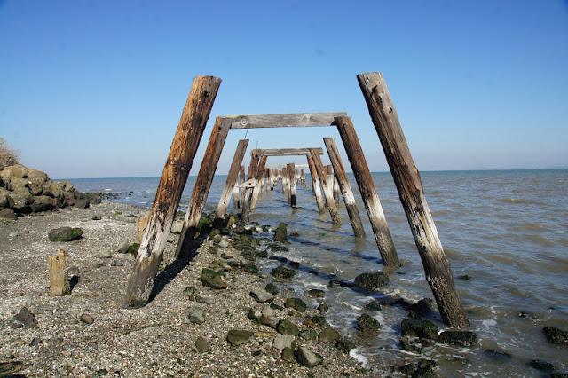
There used to be a dynamite factory in the cape of Point Pinole, in Richmond. Evidence for that violent past can still be seen in the grass-covered, decaying bunkers, the old red-brick pavement remains embedded in the hard-packed trail, or the rotting wooden poles sticking from the bay water where the old dock used to be.
Today, Point Pinole is a lovely place to go hiking.
I parked and walked across the railroad overpass that leads to the park. Looking down from the bridge I caught sight of a cute couple of California Towhees. The female came out prettier:
California Towhee, female
It can be wind-swept and cold most of the year, but on the fall day I was there, it was sunny and beautiful. Moreover - there was no wind at all, and the bay was as calm as a mirror. After crossing the pedestrian bridge I immediately turned left onto the Bay View trail.

It was a beautiful, calm day, but distance visibility wasn't all that great. On the other side of the bay I could barely see Mount Tamalpeis through the haze.
Across the bay: Mt. Tamalpeis looming
I continued north along the Bay View trail. Patches of salt marsh wetland extend between the shore and the water, painted rusty-red with late fall pickleweed and alkali grass. Numerous ducks an coots were swimming between the weeds.
The salt marshes at Point Pinole are not as extensive as the ones of the southern regions of the bay but they are no less important. They provide unique habitat for birds and other animals and function as a buffer and a natural filter for flood water running from the shore into the bay.

Salt marsh on the west shore of Point Pinole
The salt marsh coverage of the shore in Point Pinole is not complete. Where it was possible, I went down to the pebble beach. A thick line of drying seaweed marked the strandline. Lifting some driftwood, I saw many mudskippers scurrying away.

The low tide exposed the dark pebbles and mud flats, laying a feast for multitudes of shore birds.

There were many species of waders all along the shore. Some as familiar as this willet,
Willet
or the black-bellied plovers (in their white-bellied winter plumage):
Black-bellied plover
Some were new to me, like the black turnstone:
Black turnstone (middle) and Dunlin
It was quite challenging to photograph them from up close, particularly when an overly-excited dog came charging from behind me and scared them into flight.


I returned to the trail and photographed this cute little feller watching the world from atop its bush:
White-crowned sparrow
Away from the shore, the trail led me mildly up the hill an into the woods. The dominant tree in Point Pinole is the Eucalyptus - an immigrant from Australia that took root very successfully in the bay area. A rustle of leaves caught my attention and, after stalking a chickadee for a few minutes I was successful in photographing this downy woodpecker:
Downy woodpecker
Soon I came across one of the bunkers - a reminder of the park's history.
The old ruins were completely covered with weeds. Last year's dry weeds and this year's new growth. I liked the sight of fresh new shoots of fern bursting from underneath the crumpled, dry ones from the previous season.

I continued north, and almost without noticing I found myself on the edge of the cliff. Looking down I saw a large flock of coot resting on the calm water, all facing south.
Looking up, I saw this California gull hovering over me:

And looking to the east I caught sight of this pretty couple of Western bluebirds, sitting on a Eucalyptus branch:

Fall time isn't flowering season. Still, this bush displayed a nice splash of red color to the cliff edge. No, these aren't flowers, but the red berries of the Toyon bush.
Toyon bush carrying berries
Near the Point there is this beautiful, single eucalyptus, standing big and tall like a landmark.

The cliff extends all the way to the Point. The Marin peninsula across the water was completely invisible in the soupy air.
From the cliff, the trail climbs steeply down to the dock. There were a few anglers sitting there, waiting for fish. I passed on walking all the way to the end. Instead, I wend down to the shore again and looked for crabs under the rocks.

The dock
A ghost from the past: the ruins of the old dock protruding from the water next to the new dock, serving now as a bed for barnacles

and as a perch for birds.
Great egret perching on the old dock.
After exploring the dock area I continued east on Owl Alley trail and Marsh trail. The salt marsh on the north shore of Point Pinole is considerably more extensive. 


At the time of my hike there were some construction going on on the eastern side of the park. I turned south on Cooks Point trail and headed back to the park's entrance, stopping only to photograph this interesting fungus on one of the eucalyptus trees:


Out of the woods and away from the shore the view is of open grass land dotted with toyon and other bushes, to dispersed to be considered chaparral.


My entire hike was just 3.5 miles long, and very easy. Yet, it took me more than 3 hours to complete, as I walked leisurely, relishing every moment of that gorgeous day and taking in everything around me.
Less than a week after, I took the whole family for a hike there and Papa Quail caught this hawk on camera:
Red-tailed hawk
I will finish with a photograph from our first visit to Point Pinole three years ago, on a cold and very windy day, because I missed the terns this fall.


Friday, November 16, 2012

One hundred years after: Hiking Hetch Hetchy Valley

Place: Hetch Hetchy Valley,  Yosemite National Park, California
Coordinates: 37.9466, -119.7873
Date: July 2, 2009
Difficulty level: easy to moderate.


North of the famous Yosemite Valley there is another one - a valley deep in the Sierra Nevada mountain range, carved in the granite by the ice age glaciers. A hundred years ago it also looked like the Yosemite Valley: deep and rich with vegetation, with waterfalls pouring down the cliffs and collecting into the Tuolumne river, running on the valley floor.
This is not how it looks today. On 1913 the long time battle, led by John Muir,  to save the valley was lost. The congress passed a decision to build the O'Shaughnessy Dam.

The dam was competed on 1923. This is how Hetch Hetchy Valley looks today*. It is how it looked five years ago when we went hiking there.

Hetch Hetchy Valley at 2007
Hetch Hetchy Valley is not on the route of our usual Yosemite visits. We took the opportunity of our camping trip to Cherry Lake and so, after breaking camp after the second night, we drove south to the flooded valley.
Hetch Hetchy is only a short day's hike from Lake Eleanor, but it was not for us with the little chikas in tow. So we opted for the longer and quicker way of driving there. I must admit that the sight of the huge lake locked behind that deep dam is quite impressive:

The O'Shaughnessy Dam
We parked on the south side of the dam and looked around. To get to the north shore trail we had to cross the dam. To the west - it's really a long way down.

Rainbow in the spray over the Tuolumne river. 
North of the dam the trail goes through a tunnel curved in the hard rock. A violet green swallow was nesting there and we caught sight of the yellow-lipped fledgeling peeking outside.


Early July is springtime in the high Sierra Nevada, and everything was blooming around us.

Mariposa lily
Castilleja densiflora

Although there were many colorful flowers everywhere, those who got most of my attention were the local orchids, which were quite modest in appearance.


Spiranthas

Green bog orchid
The rocky cliffs of Hetch Hetchy Valley
Our original plan was to hike only to Tueeulala Falls, about a mile and a half east of the dam, but when we got there we saw that it was running but a trickle. So we crossed the little stream and continued onward, me carrying the younger chika, and the older one, who was only four years old, walking hand in hand with Papa Quail.


The trickle of Tueeulala Falls making it's way to the lake


We could see the Wapama Falls ahead and made our way over there.


The view of Wapama Falls from the trail
Unlike Tueeulala, the Wapama Falls were gashing with water. The trail goes on a board bridge over the stream and we were abundantly wetted by the spray. Like other falls in the Yosemite Valley, this one is just as spectacular.


Wapama Falls
Wapama Falls is nearly three miles east of the dam and we definitely pushed the chikas ability walking all the way there. Papa Quail carried the older chika on his shoulders part of the way back.

Going back west. The straight line at the end of the lake is the dam. 

We didn't encounter any major wildlife on this hike. Some birds, and this pretty lizard who stayed put long enough to be photographed:

Our hike, in and out:


We arrived back at the parking lot exhausted. This nearly 6 miles long hike was the longest we did with the chikas up to that time. The little one, who was under two, had to be carried (by me) practically all the way. The older one did most of the walk on her own young feet. On her next major hike she would ascend Cinder Cone all by herself!

There is a movement calling to demolish O'Shaughnessy Dam and restore Hetch Hetchy Valley to its natural state. The dam was built through a congress vote, is owned by the residents of San Francisco County and is built and operated on Federal grounds. It is part of a water system that supplied a major part of the Bay Area, myself included, with fresh water. A measure was put forth in the last elections, called for an 8 million dollar proposal to study alternative water supply to San Francisco, should a decision will be made to demolish the dam. That measure fell by a majority of 77%. People in San Francisco are just not ready to think of alternatives yet. It is easy to continue with what already exists.

This year is the 100 anniversary of that congress decision to dam Hetch Hetchy - the Raker act.  I don't know if it is possible to restore the valley to its natural state, and maybe there is no going back from here. It is, however, a striking evidence to the scale of the change that can happen in nature with a single voting stroke, to alter forever one of Nature's treasures in order to provide resource for people in a far removed place.
Here is a link to a Los Angeles Times news article discussing the measure's failure.
Here is a link to a Sierra Club web page with early 1900 photos of Hetch Hetchy Valley, before the dam was built.

And here's one last look on nowadays Hetch Hetchy, a view east taken on the trail:
Hetch Hetchy Valley: a look to the east from the trail. 

*August 30, 2013 update: The southeast side of Hetch Hetchy now burnt by a the huge rim fire that consumed over 180,000 acres of forest at the northeast part of Yosemite.