Date: December 2, 2016
Place: Sunol Regional park, Sunol, California
Coordinates: 37.533137, -121.832930
Length: About 6 miles
Level: moderate
On Friday, December 2, I realized that I had missed the deadline to turn in my East Bay Regional Parks Trail Challenge log. Oh, well. I know I had fulfilled the requirement, and that's what matters. So I went to celebrate my little achievement checking out a new trail - the Maguire Peaks Trail at Sunol Regional Wilderness.
I had wanted to hike this trail for some time now, ever since I had realized that the Maguire Peaks are within the boundaries of Sunol Wilderness. When recently the chance came I jumped on it and went on this hike.
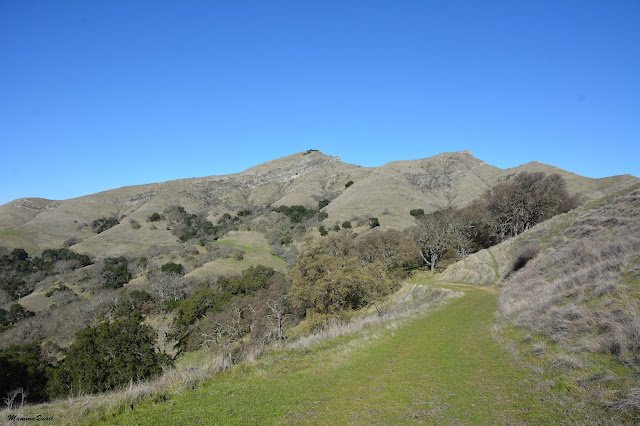
 |
| Upper Peaks Loop access trail |
The Maguire Peaks Loop Trail is accessible from three different trailheads, two of them are on Welch Creek Road outside of the park's gate. It is a narrow two-way one lane road running through the deep Coal Mine canyon. This road has very few pull outs and parking places, and any car that parks there has to have a proof of park entry payment (meaning the EBRPD parking tag or a receipt acquired at the park's main gate on Geary Road).
The lower access trail isn't marked and there is no obvious parking area near it, so I missed it completely and parked at the upper access trail. There is a small and very inclined pull out area and a gate marked as fire lane behind which started a wide gravel going uphill.
 |
| My hike, labeled yellow. |
I was a good 100 yards into the trail before I remembered to rush back down and display the parking tag in my car.
 |
| Upper Maguire Peaks Trail |
The air was filled with calls of acorn woodpeckers. It didn't take me long to spot them too. One I saw in action, stuffing an acorn into a hole in his family granary tree.
 |
| Acorn Woodpecker, male |
Some distance up the trail I saw a surprising sight - a couple of coast redwood trees. Surprising because these trees aren't naturally found separated from their grove, and the exposed hillside isn't a niche where this species thrive. The trees I saw didn't look more than a few decades old and while green and cone-bearing, they didn't look particularly thriving. While I cannot rule out the possibility that these two trees had sprouted there on their own I think it is quite likely that they were planted there, like other redwood trees I see growing in urban landscapes.
 |
| Coast Redwood, Sequoia sempervirens |
Supporting my hypothesis that these redwood were planted and possibly cared for by human settlers in earlier years I got from other trees that grew adjacent to the redwood. These were olive, tamarisk, and eucalyptus, all of which are introduced species brought hither by European-descent settlers.
 |
| Exotic Tree Grove |
Following the wet beginning of winter the hills were aflame with fresh green growth that didn't skip the trail. The cows didn't skip the trail either, and so I found my path blocked by three cows (the third is off to the left) with their young calves next to them.
I'll share here that throughout all my years of hiking solo, the only times I experienced hostility from anyone was from mother cows. I therefore took the situation seriously and left the trail, circumventing the cows while maintaining a safe distance between them and myself.
 |
| Free Ranging |
I rejoined the trail past the cows and sighed with relief. A few steps further and I felt reassured enough to stop and focus my attention on some juncos that hopped in and out of the trail side bushes.
 |
| Dark-eyed Junco |
The slope was mild but I constantly gained elevation. At some point the view opened up and I could how high I already was.
I went on and turned the curve. Around it I saw my first view of the Maguire Peaks from the trail.
 |
| The Maguire Peaks |
The trail stopped ascending, and then continued down into a small, forested valley. My eyes caught a slight movement on the slope above me and when I looked up I saw two deer that were observing me from a distance.
 |
| Black-tailed Deer |
In that small Valley the trail connected with the Maguire Peaks Loop Trail. I decided to walk it counter clock-wise, so without a stop I continued to the right into an avenue of wintering oaks.
On a lower branch of one of these naked oaks stood a Say's Phoebe. I managed to get a few photos from a distance, but as I advanced up the trail the bird flew away.
 |
| Say's Phoebe |
Striding along I slowly curved around the peaks, constantly gaining more height. Eventually I could once again see the taller of the double peaks, towering over me still.
 |
| Maguire Peaks |
And the view to the north opened up, revealing Mount Diablo and a glimpse of the San Antonio Reservoir in the Pleasanton Valley below.
 |
| Mt. Diablo |
As I continued circling the peaks more views opened up before me. I was especially fascinated by the ridge to the north, outside of the park's boundaries, that featured a lovely display of the East Bay hills' scene, where the convex surface is and open grassland and the concave densely wooded.
Those are the lines of runoff.
As I hiked the northern part of the loop the higher peak was now within my view constantly. I admired the cliff rocks, visible under the top soil and vegetation. The rocks had quite a few cavities - I assume that there are those beings who would call these home.

And right by the trail - a single coyote brush covered with tiny parachute seeds. A very pretty sight
 |
| Coyote Brush, Baccharis pilularis |
Presently I arrived at the northwestern tip of the loop trail and I found a bench there on which I had no time to sit - it was already getting late and I wished to go up to the peak too.
The map doesn't show any trail leading to the peak itself but there is a trail - a narrow and steep one that begins right at that bench. I started up the trail and soon found it wet enough still to be quite slippery and potentially dangerous. I continued slowly and carefully, but I wouldn't recommend it to anyone who isn't sure-footed.
Along the way I saw many rocks protruding through the topsoil. Here and there there were also some plants blooming, the most conspicuous of them was the red-flowered hummingbird trumpet.
 |
| Hummingbird Trumpet, Epilobium canum |
The Maguire Peaks are a prominent landmark, most noticeable when driving south on I-680 between San Ramon to Sunol. These would be the double points that stick out westward of the ridge east of I-680. Once seen, they cannot be missed or mistaken.
The higher of the double peaks is 1688 feet high and is prominent indeed. Standing there I had a magnificent view all around. I could only wish that the air was clearer.
 |
| View northeast from the upper peak. The three peaks on the horizon left to right are Mt. Diablo, the Morgan Territory, and Brushy Peak. |
It was also quite windy up top and as soon as I caught my breath after climbing I had to don my sweater.
 |
| View north and slightly west from the upper peak. The bulge in the center past the valley is Pleasanton Ridge. |
I decided that I could spare a few minutes to snack and so sat down to eat and enjoy the magnificent view.
 |
View northwest from the upper peak. Below are the Hayward Hills and past them are the city of Hayward and the San Francisco Bay. On the horizon - the San Francisco Peninsula with the peak off the center to the right being San Bruno Mountain.
|
I could see more distance to the north and east, where the ridges are lower. In the other directions the peaks are close and more prominent. They were quite a sight as well.
 |
| View west and slightly south from the upper peak. Under the antennas is Mission Peak. |
I walked around the peak a little bit, looking in at all four winds (and some more).
 |
| View to the south and slightly east from the upper peak. Somewhere at the bottom a bit of the San Antonio Reservoir is visible. The shadowy peak on the horizon belongs to the Mt. Umunhum, south of the city of San Jose. |
From the top of Maguire's higher peak I could see almost all the other prominent peaks of the Bay Area. I could even see (barely) Mt. Tamalpais. Interestingly, the one peak I couldn't see was that of the highest mountain in the Bay Area - Mt. Hamilton. That peak with it's distinct observatory dome was hidden behind the ridges on the southeast.
 |
| View to the east from the upper peak, featuring the rest of Sunol Wilderness. The tiny peak on the horizon is Rose Peak in the Ohlone Wilderness area. |
A crown of small live oaks decorated the upper Maguire Peak. Underneath the oaks I found some pretty mushrooms that had sprouted following the recent rains.
 |
| Mushrooms on upper Maguire Peak |
We had very good rains so far, but a pitiful mushroom show. I wonder if that's because there was so much mushroom bloom in the last three years and now these organisms are spent and need to put their energies into vegetative growth. Still, the few a saw I thoroughly enjoyed.
 |
| More ushrooms up upper Maguire Peak |
Eventually I checked the time and gasped. I might be able to be at school on time to pick up the chikas if I'd run all the way back. But there was no running that steep and slippery trail down Maguire Peak, not if I wished to get down in one piece. So I walked down as fast as I could with care, stopping only once to photograph another plant that was blooming on the slope.
 |
| Bristly Goldenaster, Heterotheca sessiliflora ssp echioides |
Once I reached the Maguire Peaks Loop Trail again I broke into a brisk stride. The trail was wide and convenient at first, but soon I had to slow down once more: I had reached a trail segment where cattle had trodden there while it was still muddy from the rains. The result were that the trail was completely plowed and hardened as a jagged surface were there was no hope for even steps and a steady speed.
At least the view remained fantastic.
I curved again around the peaks and was walking on the south side of loop, going in and out of narrow gullies covered with oak trees. The peaks, that towered over me, I could not see at all.
The trail improved some distance later and then the peaks came into my view again. At least their southern cliff side. What caught my eye was the grove of wintering oaks (possibly black oaks, but I don't really know), that covered the slope just below the cliffs.
Oak trees have a majestic quality to them, and are revered in many world cultures, including the native East Bay Ohlone people. Being key species in the area, oaks are an essential part of local habitats. They are also very beautiful and awe-inspiring.
 |
| Live Oak, Quercus agrifolia |
Throughout my hike I did not encounter a single human being. Ignoring the trail itself, it was easy to imagine I was walking in a complete wilderness. I was very dismayed, therefore, to see one of those accursed mylar balloons, partially inflated still, tucked under one of the oak trees I passed on my way. I don't know who that princess was, but she should have done a better job keeping it from escaping and desecrating the wilderness.
 |
| Yes, I did remove it. |
I was nearing the turning point to the Upper Peaks Trail that would take me back to Welch Creek Road when I saw the cows again. They were the same three cows that I met on my way up. Since I saw them they had moved up too and were now grazing to not too far from the trail on my right. Great, I thought. They're not blocking my way now. But then, where are their calves?
I looked around and to my horror I spotted all three calves in the trees left of the trail. The hills sloped sharply on either side so there was no going around this time - I had to stick to the trail - that run between the calves and their mothers.
I walked slowly, trying to keep eye contact with the nearest cow yet not ignoring the other two. The cows too eyed me suspiciously, and started moving towards their calves. The calves got nervous and were edging towards their mothers, so all of us were now converging onto the trail ...
At one point one of the cows started trotting towards me. I locked my gaze on her and raised my hiking poles. She stopped. Another cow was coming from behind and I waved my other pole at her. All the time I kept moving slowly, talking calmly to them, and stopping whenever it looked like the calves might reunite with their mothers. Eventually the cows crossed the trail and joined their babies and I passed through. It was a very scary experience, and it cost me some dear time too.
 |
| Down the trail back to Welch Creek Road |
It was exactly time for school release when I finally reached my car. I was lake picking up my chikas but finally the forth mother in this story was reunited with her young as well.
A note to myself - revisit this trail in the spring. I look forward to seeing the poppies bloom on the Maguire Peaks.


