Sunday, September 29, 2013

Black Beauty: Black Sands Beach at King Range National Monument

Date: July 4, 2013
Place: Black Sands Beach, Shelter Cove, King Range National Monument, California
Coordinates: 40.04525, -124.07852
Difficulty: easy

The 4th of July this year happened on a Thursday. Add the following Friday and you get a 4-days long weekend - a great opportunity to travel!
We had originally planned to go back to the Trinity Alps but an insanely long heat wave was going on and the forecast for that area wasn't very appealing, so we decided to take the coastal route to Willow Creek. On our way there we decided to check out another green area on our road map: King Range National Monument. So in Garberville we turned west and drove for an hour on a narrow and winding road until we got to the little town of Shelter Cove.
King Range National Monument is a magnificent coastal range and is designated wilderness. Like Carrizo Plain and the Santa Rosa and San Jacinto National Monuments, King Range too is managed by the BLM.
With some difficulty we found the parking lot for the Black Sands Beach and found that it was full: it is the parking place for backpackers who go into the wilderness from that spot. So like others, we parked along the narrow road leading to it and headed down to the beach. 
Black Sands Beach
A tiny creek was flowing alongside the beach access trail.

With lovely yellow flowers alongside it.
Oregon Gumweed (Grindelia stricta)
Once on the beach itself, there is no trail, just walking as far as one wills along the strand line. Those who wish to hike or backpack beyond the first four miles should keep track of the tide timing, as certain segments of the King Range coast are inaccessible during high tide. A map that outlines these areas is available for purchase at local stores.


Black Sands Beach didn't get its name for nothing:

 I was completely taken by the shiny black pebbles. The black sand is even more impressive when contrasting with the white ocean foam:

Rotting kelp was heaped here and there along the strand line, giving a very distinct aroma to the beautiful scenery.  When I lifted up the kelp, swarms of little sandhoppers jumped frantically to find new shelter.

We didn't walk very far along the beach. bit less than 1 mile out, although one can go up to 4 miles out without worrying about tides. At some point we sat down for a snack at a group of inviting rooks. Behind us, at the bottom of the hills, water was seeping out of the ground, creating a small delta where a few grasses grew, and disappearing once more into the sand.

At that point we turned around and went back. We continued walking south beyond the place where we entered the beach, toward a group of large rocks that protruded into the water, scaring a few gulls along the way.

The rocks in the water were overgrown with a pretty type of seaweed called 'sea palm'. I was mesmerized by the waves that washed again and again over the sea palm groves.

The big rock on the south side of the beach has a long cave that opens into the water. The waves were washing through the cave. Naturally, I looked inside and, attracted by the little spot of light in the back, I crept in a bit further.  On the cave walls were clinging groups of barnacles. A small hole in the ceiling lit in a ray of bright light, creating a small circle of illumination on the water. Really, all that was missing was a pirate's treasure chest :-)

Just outside the cave I found this little guy: an isopod that lives in rocky tidal zones. In fact, it wasn't all that little, about an inch long it was.
Ligia occidentalis
After exploring the wet side of the beach I turned my attention and camera lens to the dryer one. It was all bright-green and spotted with colorful flowers.

Some of them were easy to photograph,
Seaside Fleabane (Erigeron glaucus)
and some played hard to get :-)
 Bluff Lettuce (Dudelia farinosa)
The rocks there are highly porous and brittle. Water was seeping through many of the cracks and in turn, these wet cracks were covered with vegetation. 
Yellow Monkeyflower (Mimulus guttatus)
I risked climbing them to get a close-up of some of the more attractive ones:
Western Columbine (Aquilegia formosa)
A flashback from the by-gone past: horsetail is one of the oldest plant species on Earth. I am glad they are still with us today too.
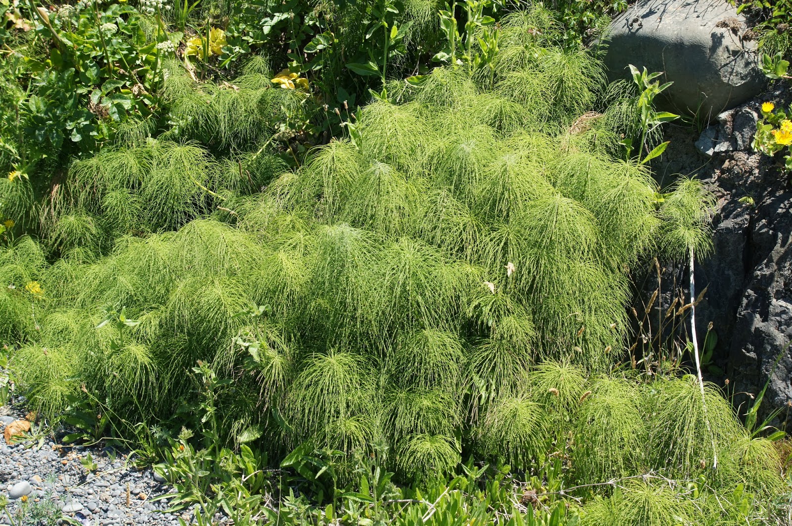
Common Horsetail (Equisetum arvense)
One of the most common seaside plants: the Seaside Buckwheat. They often are large shrubs but these were little plats that clung to the rock walls. I am not completely sure of the identification, but nothing else looked similar.
Seaside Buckwheat (Eriogonum latifoium)
After wandering about for some time, taking all of it in, we had to say goodbye to that lovely beach and move on on our way to Willow Creek. It was just a small taste of the place, and we left with a promise to return.


Many thanks to members of the California Wildlife Appreciators group for their help in identifying the rock Isopod.

Tuesday, September 24, 2013

The Last Day of Summer at Marin Headlands

Date: September 20, 2013
Place: Marin Headlands, Golden Gate National Recreation Area, Sausalito, California
Coordinates: 37.83225, -122.53899
Length: 3.2 miles
Difficulty: Easy to moderate

Last Friday I went to check out a possible trail for the chikas' 4H group. After a grueling drive through the Bay Area traffic and the road constructions at the Marin Headlands, I made it all the way to Rodeo Beach and parked there.


The weather that welcomed me was typical for the north pacific summer: chilly and gray with fog.
A lone surfer at Rodeo Beach
Almost immediately I spotted my first, and most exciting, wildlife: a small group of dolphin cruising northward along the coastline.
(Common) Dolphin
The dolphins disappeared behind the rocks and I ascended the bluffs due north.
The fog wasn't too dense but it did hang low and gave the landscape a hazy, dreamy appearance.  
A grove of cypress in the fog.
It being the last summer day, I didn't expect much to bloom. And sure enough, there was no spectacular display of colors. Some plants, however, did do their best to put up a show:
Coyote Brush (Baccharis pilularis), a common member of the coastal scrub. 
Some more than others:
Coast Indian Paintbrush (Castilleja affinis)
Seaside Fleabane (Erigeron glaucus)
 I continued north all the way to the vista point. The Northern California coastline is widely known for its spectacular beauty. Even shrouded with fog it is still breathtaking: 
Marin Headlands coastline
The numerous rocks protrude from the water along the coastline, like jagged gray teeth. For sea birds, they are a sanctuary. For boats it is a serious hazard. Indeed, throughout my entire hike I could hear the foghorns from north and south, warning seafarers so keep their distance.
Cormorants on a rock.
I turned about and went back to the trail that was going up to Battery Townsley. On my way I could hear many birds in the brush. The chaparral is a perfect hiding place for little birds but that nakes it very difficult to see them. Eventually, I did manage to photograph two of those little brown birds: A white crowned sparrow, it was.
White-crowned Sparrow, adult and juvenile
The only challenging part of the loop I hiked is the ascend to Battery Townsley, and even that is on wide and convenient road and is only 0.4 miles long.
Outside Battery Townsley, a view from Wolf Ridge Trail.
During the 1940's the coast of California was fortified against attack from the sea. Battery Townsley was one of the gun batteries that were placed to protect the Golden Gate. In a heavily armored bunker was installed this huge 16-inch gun that could shoot projectiles as far as 25 miles into the ocean and required a team of 35 men to operate. The guns were fired, but only for practice and never used in combat. Eventually, they were scrapped. (The gun in the picture above was brought from the USS Missouri at the end of the Korean War.)
Battery Townsley
Shortly after I left Battery Townsley the trail connects with the Wolf Ridge Trail, and turned east, taking it down back to the lagoon. There were a few pretty flowers along the trail:
Coastal Tarweed (Deinandra corymbosa)

Common Sandaster (Corethrogyne filaginifolia)


But mostly it was the green-gray chaparral, dense scrub filled with invisible, yet very audible, little birds.
A line of fern seeming two hills
I had expected the fog to lift up but it just seem to get denser. Wisps of cloud were hanging low over the valley and shrouding the hills.

The trail leads directly into the Headlands Institute. There's a picnic bench there, where I sat down for a quick lunch and admired the deer that were grazing right next to me without fear.

After my lunch break, I took the loop trail around the Rodeo Lagoon. The north portion of the trail is right next to the road with very little to see, so I strode it quickly and crossed the bridge east of the lagoon.
Cattails on the northern shore of Rodeo Lagoon
The lagoon was very calm, and overgrown with algae. The fog over the reflection made it look like a scene from some magical fantasy world.
Rodeo Lagoon
I didn't see any sword sticking out of the water. Just this heron who, right after I took its photo, got lucky at catching something.
Great Blue Heron
The trail along the lagoon's southern shore is hidden deep in the vegetation, green year-round.


I was particularly impressed by this gnarled Eucalyptus tree, branching out its colorful boughs, as if grabbing for something. I love trees with personalities.

The trail ascends mildly on the hillside, allowing a full view of Rodeo Beach and the large sandbar that locks the lagoon water, separating it from the ocean.

It was right there, before going down to the beach, thatI found the highlight of my hike: a wild orchid! Still in bloom, so late in the year, a coastal Piperia elegans.
Piperia elegans, coastal
And I was also very happy to meet this lovely California Wildrose along my path :-)
California wildrose (Rosa californica)
Downhill I left the trail and, taking off my shoes, I completed my loop along the ocean strandline walking properly barefoot all the way back to the parking lot.
Western Gull at Rodeo Beach
This entire hike took me about 2.5 hours of a very leisurely walk. And yes, I do know that September 20 isn't officially the last day of summer, but on the following day it was pouring rain.


Wednesday, September 18, 2013

Riders on the Storm

Date: March 8, 2013
Place: Death Valley National Park, California

Out in Nature, away from the shelter of home, one gets to experience its force in full. In Death Valley it is most commonly the force of extreme heat. But sometimes the desert flips and shows its thunderous side. And when it does, it is no less extreme ...
This is not a hiking post, just photographs taken on that stormy day on March, after our visit to Ubehebe Crater.
On Scotty's Castle Road, due south. 
The rain itself wasn't all that intense. Not in the valley below, were we were. On the surrounding mountain ranges though, it was a different thing.
Panamint Range donning white, view from Scotty's Castle Road. 
We reached Hwy 190 and continued driving south toward Furnace Creek. For some time, the hills to the east were completely invisible.

It is well known that prime desert hazards are heat stroke and dehydration. Flash floods, however, is a prime cause of fatalities as well. Better not get trapped in a canyon when the mountains above are getting a soak.


Most flash flood fatalities, however, occur in vehicles. It is easy to underestimate the power of running water. Having grown up in the desert myself, I've seen it too: upside down cars, even large trucks, stuck in the mud because their drivers thought they could cross the flowing wash.
This Jeep crossed just fine, no fatalities here:-) 
The storm didn't last very long. about two hours, maybe. The clouds still hung over the mountains, but late afternoon sun found its way to the lower slopes.

The contrast could not be any sharper: the Mustard Hills, bright yellow in the late afternoon sun, under the looming snowy and dark Winters Peak. My friend and I stood there at Harmony Borax Works and photographed this inspiring view again and again until the sun had hid itself again and both landmarks fell under the shadow.
Mustard Hills (in front) and Winters Peak.  
But it wasn't just eastward that I pointed my camera too. The low setting sun is particularly good in bringing out the contours of the mountain slopes.
Telescope Peak (or Wildrose Peak?) view from Harmony Borax Works.
The sun was setting fast. After some wandering about in the Mustard Hills we got back into the car and drove to Death Valley Junction, where we would spend that night, getting ready for the big hike we planned for the morrow.
Evening sky in Death Valley, March 8, 2013