
 |
| Rain, view northeast from Franklin Pass |
Date: June 17, 2021
Place: Sequoia National Park, Three Rivers, California
Coordinates (of the Franklin Lake Campsite): 36.419725, -118.557546
Length: 6.4 miles
Level: strenuous
The first night of my June 2021 backpacking trip in the Mineral King area of Sequoia National Park I slept in the higher campsite of Franklin Lake. It was a good night and I slept well. At dawn I drifted into wakefulness. I like this time of day, the time of peace and promises. I usually linger in the sack for a while, allowing my thoughts to roam aimlessly. This morning however, one thought invaded my consciousness. Last evening I pitched my tent without thinking it through right next to the area's only bear box - that strong metal cabinet where food should be stored to protect it (and the campers) from bears. There were other campers around the lake who stored their stuff in that bear box. It occurred to me that any moment my campsite might be crawling with people coming for their things. That thought brought me quickly to full wakefulness. I got out of the tent in time to see the touch of the first sunlight on the mountain peaks.
 |
| Sunrise at Franklin Lake |
I had my tea in peace, watching the line of light coming down the north-facing slopes on the other side of the lake. There was still no one else awake by the time I finished my breakfast. Only a single marmot that was busy with her own breakfast among the nearby rocks.
 |
| Yellow-bellied Marmot |
I grabbed my bottles, filter, and camera and climbed down the shady path to the lake. The sun was up in the sky now and the entire basin was filled with sunlight. The water glistened and the ripples shone back at me. There was no sound, not even of birds.
 |
| Franklin Lake |
I sat down to filter water and stared at the lake. Fish were swimming to and fro just below me. I knew there were fish in that lake from my previous trip there but now I got the chance to look at them better and to admire their beauty. Golden trout are native to the Sierra Nevada lakes. Those who fish them should return them to the water.
 |
| Golden Trout |
I finished my filtering and clambered up to the campsite. The wild beauty of the place shone through everything, even dead tree logs.

There were wildflowers all over the place. Not continuous mats of them but in most soil-accumulated crevices.
 |
| Mountain Butterweed, Senecio integerrimus |
The insects were also awake by then, already busy hovering between the flowers, taking care of their own breakfast.
 |
| Lewis' Flax, Linum lewisii |
When I reached back to the campsite I saw there the other campers that stayed near Franklin Lake last night. They arrived each from their tent site to the bear box to fetch their things and to have breakfast. We had a friendly chat while I was taking down my tent and packing my stuff. Both parties were at the end of their trips and were going to head down back to Mineral King. I was the only one heading deeper into the wilderness that day.
 |
| My hike to Little Claire Late as captured by my GPS |
My general plan was to go across Franklin Pass and stop for a couple of nights somewhere on the way to Black Rock Pass. When I shared my plan with the ranger on yesterday's morning when I picked up my permit he suggested that I'd stay at Little Claire Lake which was in between Franklin Lake and the Big Five Lakes complex. Little Claire Lake was only about 6.5 miles away from Franklin Lake and my first thought was that I could walk farther. After yesterday's hike though, and with an expected ascend to Franklin Pass, at the height of 11,760 ft, it seemed more reasonable to take it easy and enjoy the hike rather than rush myself in the sake of distance coverage. An important goal of mine for this trip was to spend as much time as possible in the high altitude and I wouldn't want to finish the trip too quickly.
 |
| Franklin Pass Trail |
After packing up I scrambled back to the trail which was high above the lake. The trail stretched to the southeast, toward the granite walls of the Franklin basin. I could sort of tell where the pass was, but I didn't see the trail leading to it. I trusted my map and navigator and started up the trail.
 |
| Monkeyflower, Erythranthe sp. |
The trail remained level as long as it followed the line of the lakeshore below. I passed occasional tree stands on my way, and paused only to take photos of wildflowers and other sights.
 |
| Brewer's Mountain Heather, Polydoce breweri |
Near the southeast end of Franklin Lake the trail started curving east and the slope steepened. I was also starting to feel again the effect of the high altitude. I was walking slowly on an uphill slope which wasn't all that steep but I was breathing heavily already. I could also see the treeline ahead. Here there was a very real and sharp boundary above which no tree grew.
 |
| Franklin Pass Trail |
Vegetation was more scant up here, and the plants that did grow there were small. Even the trees near the treeline were small versions of their species. I was therefore surprised to see a blooming checker lily, the same checker lily species I saw yesterday at a much lower altitude. Now I was seeing it above the lake at about 10500 ft elevation.
 |
| Pine Woods Checker Lily, Fritillaria pinetorum |
The checker lily was growing in a moist spot, underneath a group of bushes. Some wild currant bushes were in that spot and I spotted a ladybug on one of them. I love ladybugs.

A few steps further the trees were almost gone and the vegetation became sporadic. Little, flat shrubs poking through the granite gravel or shying below large rocks. From a distance the area looked almost barren.
 |
| Franklin Pass Trail |
From a closer view however, all the little shrubs and wildflowers were very visible and lovely. And there was wildlife too - a busy alpine chipmunk hopping here and there, munching on heather flowers, eyeing me carefully as I walked by and photographed it.
 |
| Alpine Chipmunk |
Tiny shrubs of Nuttall's sandwort, like clumps of little starlike white flowers, were visible only on proximity, they blend so well with the granite gravel. The bees have no problems seeing them, of course.
 |
| A bee visiting Nuttall's Sandwort, Minuartia nuttallii |
Further up the trail I could finally see the Upper Franklin Lake, the one I knew about only as a blue dot on the map. The upper lake was off to the south and the pass trail was veering to the east. If I wanted to take a closer look at that lake I would have had to leave my trail for a special detour. I could have done that I guess, but the thought didn't come to my mind at that time. Off trail exploration can be very exciting and I might do it on my next trip in the area.
 |
| Upper Franklin Lake (left) and the south end of Franklin Lake (right) |
Almost as soon as the trail begun ascending in earnest it also became harder to walk on. When climbing a slope of small, loose gravel, much of the energy of each step is absorbed in the gravel sinking under the feet rather than pushing the body uphill. It reminded my the ordeal of going up the Sawtooth Trail above Monarch Lake, on my Mineral King trip of 2016 with my friend. Here at least, the slope was fairly mild and despite the increased effort I made good progress. That is, when I wasn't pausing to take photos almost every step of the way.
 |
| Pine Violet, Viola pinetorum |
Some of the gravel seemed to be moving. It wasn't my imagination and not the effect of thin air on my brain - these were many blue butterflies linked in mating, part hopping, part almost flying, and part fighting one another. Fascinated, I watched the spring scene for some time before moving on.
 |
| Blue Butterflies, Mating |
I came by a large boulder that was close to the trail. On both sides if that boulder a river of greenery flowed down the slope, following the moisture that was left there by a recent flow.
 |
| Franklin Pass Trail |
From a distance I could make out mainly the shooting stars but when I came closer I saw that there were many other wildflower species there, some I remembered from previous trips in the area that I know to be unique to the high mountains.
 |
| Alpine Ivesia, Ivesia gordonii |
The ledge stonecrop that I met yesterday was becoming a regular friend on this trip. It looked like it was just beginning its bloom, too.
 |
| Ledge Stonecrop, Rhodiola integrifolia |
And then there were the carpets shooting stars covering the entire moist area. Some of them were growing individually off to the side, blooming prettily against the granite background.
 |
| Alpine Shooting Star, Primula tetrandra |
On the other side of the boulder I actually did see some surface water trickling down the gravely slope. Most of the trickle was well hidden by the crowding vegetation, including low bushes of mountain gooseberry.
 |
| Mountain Gooseberry, Ribes montigenum |
A few more steps past the boulder started the switchback section of the trail. It was difficult for me to follow with my eyes the thin line on the light gray gravel slope. After the first switchback it was no longer clear where the trail was going. I simply had to trust that it would take me to the Franklin Pass and not divert me into an unplanned destination as happened to me on the day on my 2016 trip with my friend when we tried going up Sawtooth Pass but ended up going through Glacier Pass.
 |
| Franklin Pass Trail |
The trees were left behind, far below me. The little shrubs and the annual plants were few and far between now. I knew that I was walking on earth that until recently was covered with snow. Even after the snow melted, the conditions up there are harsh - winds, radiation, shortage of accessible water, and of course the cold. These conditions are not supportive of growth and all the plants that do grow there had evolved specific adaptations to survive, even thrive, in these heights. These were the alpine plants that I was so eager to see. That I would have to take these long trips to visit their own world.
 |
| Frosted Buckwheat, Eriogonum incanum |
The day started with clear sky and bright sun but as the morning progressed clouds started gathering above me and the sunlight dimmed. There was no rain in the forecast for this area for the days I was there but unpredicted rain, even hail and snow, is not uncommon in the mountains. The wind also picked up and I pulled my wind breaker from my backpack and wrapped it around myself.
The clouds took time to cover the sky and high above the horizon I got to see the light shining on the high peak to the northwest.

The patches of sunlight, lit through holes in the cloud cover became more scarce. Most of my photos from that art of the trail appear more gloomy although I did get some nicely illuminated ones just before reaching the pass.
 |
| Tidy Lupine, Lupinus lepidus |
Almost all the way up I wasn't able to see the trail more than a few yards ahead of me. The contrast with the granite was very poor and the dim light made it difficult to tell the exact place where I would cross the ridge. I was reassured however, that I was walking to the right place, not only because of the direction I was walking in but also because of a man that was descending down the trail towards me. He came down quickly and nodded to me as he passed me on the way down. As soon as he passed me the rain begun. It wasn't a strong rain but I tucked my camera inside my windbreaker anyway, pulling it out only for brief moments to take photos of unique sights.
 |
| Franklin Pass Trail |
One excellent reason to pull my camera out of its protection were beautiful, intensely pink flowers that bloomed in small clumps at the foot of granite rocks. It was the first time I was seeing this species of flowers and I tried to get as many photos of them as I could. I was surprised to find out later that these were of the same genus as the very familiar shooting star that I saw earlier near the lower parts of this trail. This plant blooms very early in the summer at the high elevations of the Sierra Nevada, and this was the first time that I hiked there in June. Had I been there a month later they would have done blooming.
 |
| Sierran Primrose, Primula suffrutescens |
I also found there the mountain parsley, that I only seen before on my trips to the Golden Trout Wilderness and the Patriarch Grove at the White Mountains. This tiny plant blends almost perfectly with the granite gravel it grows on. Small and flat, it's easy to miss and hard to capture.
 |
| Clemens' Mountain Parsley, Oreonana clementis |
The rain intensified for a few moments. There were some large boulders by the trail near the top and I found shelter from the rain under an overhung ledge of one of them. Fascinated, I watched the rain drops land on the granite gravel and almost immediately disappear between the little stones. I was amazed at how dry the top layer looked still, despite having been rained on for some time.
I also had a great view of the Franklin basin where I just ascended from. Far below me was Franklin Lake where I have camped last night. The upper lake was off to the southwest, nestled between the reddish peak and the gray granite of Florence Peak, out f my view. Directly below me was a small pond, which I was sure was a large snow patch not that long ago.
 |
| Franklin Lake (and pond) |
I was hoping to stop for long break at the pass but it seemed that sitting under my rocky shelter was becoming my long stop, so I pulled out my lunch fare and relaxed, enjoying the light rain, the stunning view, and the tiny wildflowers that bloomed under the rocky shelter where I was sitting.
 |
| Granite Draba, Draba lemmonii |
Eventually the rain eased up and I got going again, the last few yards to the top of the pass. By the time I reached the top the rain had moved on.
 |
| Franklin Pass, 11,760 ft |
I was surprised to see other people at the pass. There were three young men, sitting on one of the large rocks off to the side. I didn't see them in the Franklin Lake area so I assumed they were coming up from the eastern side. I didn't go near them but made my way to the middle of the pass' saddle and took in the grand view that laid before me.
 |
| View south from Franklin pass |
The first thing I noticed was the snow patch at the top, the leftovers of what should have been a complete coverage this time of year.
There was a clear blue lake almost directly below me. On the map it is nameless. It looked very pretty though and I regretted that the downhill trail would not go by that lake.
A deep gulch, cut by the Big Arroyo Creek, opened up below that nameless lake, leading eastward, to the Kern River. I remembered visiting the mighty Kern, descending to it from the east on my trip in the Golden Trout Wilderness. I was in awe at the depth into which the river and its tributaries cut into the mountains.
 |
| View southeast from Franklin Pass |
Across the valley from that nameless lake was Forester Lake, easily identifiable by its tooth-like shape. Forester Lake was one of my options for a night stop. On the map it looked to close for a stop that day but looking down on it from Franklin Pass it seemed to be at a respectable distance. It had taken me longer than I anticipated to get to the pass, and the possibility of stopping for the night at Forester Lake seemed more than plausible now.
 |
| Forester Lake |
Little Claire Lake was behind a dip in the eastern slope of the mountain I was facing, and it was out of my view. (It would remain hidden until the I got there).
It was no longer raining over Franklin Pass but it looked like a big rain event was going on northeast of where I was. The trail I begun descending on started by veering from the pass to the northeast.
 |
| Rain in the Northeast |
I paused at the edge of the trail and gazed down. I zoomed in on a large slanted plateau before which cut the deep gulch of Rattlesnake Creek, another tributary of the Kern. Far on the horizon I could see the shapes of rugged peaks. This was the general direction of Mount Whitney, but I am not certain that that's the mountain I was looking at.
 |
| Plateau Northeast |
The trail curved back to the south and steepened considerably. I slowed down again to maintain my balance on the loose granite gravel.
 |
| Franklin Pass Trail, east side |
Around the curve I had a better view of the peaks southeast of Franklin Pass. I didn't recognize any of the rugged peaks on the southeast horizon, but I guess one of them might be Sherman Peak.
 |
| Rugged Peaks in the Southeast |
Still on the high part of the east side Franklin Pass, the trail curved one last time to the north, and before plunging below the ridgeline I saw another pretty lake below me. This lake too was nameless on my map, and I knew that I'd have to get on a large off-trail detour in order to see it up close, which would not be on this trip. I wasn't the only one who had these kind of thoughts for sure, because I could definitely see a lightly used path leading down to that lake.
 |
| View (more) Northeast |
The rugged, castle walls-like peaks on the horizon above that nameless lake captured my attention and I took a closeup image of them. I believe this is the ridge of the Kaweah Peaks.

From there the trail really steepened. There were no real switchbacks on the long way down and I felt sorry for hikers who would be climbing this slope on the path of unstable loose gravel. There weren't many wildflowers on the higher east side of the trail but i quickly descended below the elusive 'treeline' and got to see some nicely shaped, bonsai-like pine trees.

The steep gravel slope started taking a toll on my legs, and my toes in my new heavy duty boots. This, I guess, was foreshadowing the agony of the scree descent from Mount Shasta a mere week later. I had no reason to hurry though, so I slowed down and took frequent stops to ease the pressure on my toes and to look at the wildflowers, now that I descended enough to see more of them.

The eastern slopes of Florence Mountain was much steeper and seemed more arid and with generally harder conditions than the western side, what explained the relative scarcity of vegetation. As expected, most of the few wildflowers I saw on that side were tiny creepers.
 |
| Pussypaws |
Protected by rocky nooks however, trees could grow to real tree sizes.
 |
| Franklin Pass Trail, east side |
The further down I descended, I saw wildflowers in bigger numbers and diversity. Some of them I saw on the west side already but I was glad to see them here as well.
 |
| Dwarf Alpine Paintbrush, Castilleja nana |
The sky remained overcast and gloomy although the rain had ceased a while back. Daylight remained dim due to the cloud cover and I was happy to see some strong colored flowers which added gayety to the gray scene.
 |
| Wavy Leaf Paintbrush, Castilleja appelgatei |
Here and there though, the clouds begun breaking up, revealing patches of blue sky above. I welcomed every hint of a switchback on this otherwise straight downhill trail.

Closer to the bottom of the trail I noticed two elderly hikers making their way uphill. We had a brief chat when we met on the trail - they were planning to make it back all the way to Mineral King that evening. A worthy feat that would be, even if most of the way would be downhill.
 |
| Ladybug on immature male pinecones |
I took the opportunity of our chat pause to sit down and remove bits of gravel from my shoes. I also has a small snack, my first since the rainy lunch hp the west side of the pass, and I finished my drinking water. I trusted I could refill at the creek below me.

As it turned out the trail didn't take me all the way down to the cute meadow that I saw below with the creek running through it, but veered off to the left.

It looked like the sky was clearing a bit more. I reached the bottom of the big descent but the trail had bypassed the meadow and I wasn't at the creek yet. There was much more vegetation all around me however. Large, full size trees and lots of wildflowers.
 |
| Sierra Beardstongue, Penstemon heterodoxus |
A chipmunk crossed my path and quickly disappeared among the rocks off to the side. I stalked it quietly for a few minutes and eventually found it and took its photo before it disappeared again. That was the biggest wildlife I saw all day.
 |
| Alpine Chipmunk |
A bit further down the trail I finally got to the creek and immediately sat down to filter water and fill up my bottles to the brim.
 |
| Rattlesnake Creek |
By the time I reached the creek the sun had come out to stay, at least for the rest of the afternoon. It was disturbed only by a straggling cloud every now and then. I enjoyed the relaxing walk along the creek, much easier than the harsh drop from the mountain pass. It was nice to breathe the sweet smell of rhododendrons that bloomed near the water.
 |
| Western Labrador Tea, Rhododendron columbianum |
I didn't walk for too long along the creek. Rattlesnake Creek goes downhill all the way to the Kern River and I needed to go uphill to Forester Lake, which is one of the sources of Rattlesnake Creek. My trail separated from the creek, not before is saw a sole tent hidden in the bushes a bit off trail.
 |
| A forest clearing |
The way to Forester Lake splits off the Rattlesnake Creek to about half a mile of relatively easy uphill slope that cuts through a loose conifer forest of pines and firs. I was starting to get tired but I not yet fatigued, and my spirit was high.

I was making good progress on the way to Forester Lake. One treason being the relative ease of the trail compared with what i walked on before, and the second was the almost complete absence of wildflowers from the forest floor. There were lupine patches here and there but that was about it. Lupines, and an occasional pine lousewort, with is a challenging plant to photograph, being si low to the ground with its flowers blooming underneath the foliage. .
 |
| Pine Woods Lousewort, Pedicularis semibarbata |
I was toying with the idea of stopping for the night at Forester Lake all the way down from the pass. When I finally reached it however, I immediately knew that I didn't want to stay there. It looked very pretty, but as soon as I got near it I saw that the shore was very muddy, making it difficult to access the water. Then there were the mosquitos. Not hoards of them, but very present. Finally, it was still early and Little Claire Lake wasn't far away. There would be more uphill walk to get to it, but it didn't look long or particularly steep.
 |
| Forester Lake |
I didn't stay even a little bit at Forester Lake. I snapped a few photos of the calm water and then turned my back to it and started across the meadow toward the little ridge that separated me from Little Claire Lake.

When I reached the uphill part I felt my knees and feet very well indeed. I was tired. I hoped that Little Claire Lake would be a good campsite because I knew I wouldn't go any further that day. I walked slowly uphill, and the clouds started gathering overhead once more. It wasn't sunset time yet but the day was getting dimmer once again.

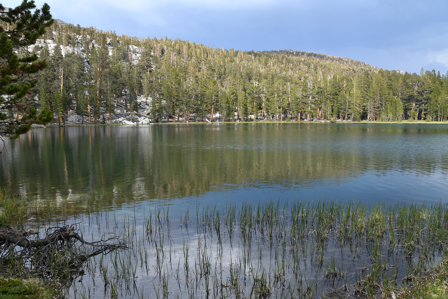
I reached Little Claire Lake and found myself all alone there. This would be the only night on this trip that I would be all alone in the area with no other campers within sight or earshot. I welcomed the solitude.
 |
| Little Claire Lake |
I strolled a little along the lake shore until I found a good place to pitch my tent. A few droplets of rain prompted me into a quicker action of pitching the tent and cooking my dinner, but the few drops didn't develop into real rain and soon I lulled back into quiet reverie.

All fed and rested and with no one to tend to or talk to but myself, I sat by the lake and watched the sun sinking behind the ridge. It was a good day and I walked as far as I intended. I was alone in tghe wilderness of the High Sierra, just as I love it.
 |
| Sunset at Little Claire Lake |