Coordinates: 37.99214, -121.35626
Hike date: November 6, 2012
Difficulty level: easy
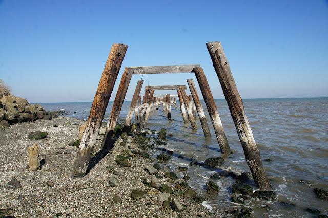
There used to be a dynamite factory in the cape of Point Pinole, in Richmond. Evidence for that violent past can still be seen in the grass-covered, decaying bunkers, the old red-brick pavement remains embedded in the hard-packed trail, or the rotting wooden poles sticking from the bay water where the old dock used to be.
Today, Point Pinole is a lovely place to go hiking.
I parked and walked across the railroad overpass that leads to the park. Looking down from the bridge I caught sight of a cute couple of California Towhees. The female came out prettier:
 |
| California Towhee, female |
It was a beautiful, calm day, but distance visibility wasn't all that great. On the other side of the bay I could barely see Mount Tamalpeis through the haze.
 |
| Across the bay: Mt. Tamalpeis looming |
The salt marshes at Point Pinole are not as extensive as the ones of the southern regions of the bay but they are no less important. They provide unique habitat for birds and other animals and function as a buffer and a natural filter for flood water running from the shore into the bay.
 |
| Salt marsh on the west shore of Point Pinole |
The low tide exposed the dark pebbles and mud flats, laying a feast for multitudes of shore birds.
There were many species of waders all along the shore. Some as familiar as this willet,
 |
| Willet |
 |
| Black-bellied plover |
 |
| Black turnstone (middle) and Dunlin |
I returned to the trail and photographed this cute little feller watching the world from atop its bush:
 |
| White-crowned sparrow |
 |
| Downy woodpecker |
The old ruins were completely covered with weeds. Last year's dry weeds and this year's new growth. I liked the sight of fresh new shoots of fern bursting from underneath the crumpled, dry ones from the previous season.
I continued north, and almost without noticing I found myself on the edge of the cliff. Looking down I saw a large flock of coot resting on the calm water, all facing south.

Looking up, I saw this California gull hovering over me:
And looking to the east I caught sight of this pretty couple of Western bluebirds, sitting on a Eucalyptus branch:
Fall time isn't flowering season. Still, this bush displayed a nice splash of red color to the cliff edge. No, these aren't flowers, but the red berries of the Toyon bush.
 |
| Toyon bush carrying berries |
The cliff extends all the way to the Point. The Marin peninsula across the water was completely invisible in the soupy air.
From the cliff, the trail climbs steeply down to the dock. There were a few anglers sitting there, waiting for fish. I passed on walking all the way to the end. Instead, I wend down to the shore again and looked for crabs under the rocks.
 |
| The dock |

and as a perch for birds.
 |
| Great egret perching on the old dock. |
At the time of my hike there were some construction going on on the eastern side of the park. I turned south on Cooks Point trail and headed back to the park's entrance, stopping only to photograph this interesting fungus on one of the eucalyptus trees:
Out of the woods and away from the shore the view is of open grass land dotted with toyon and other bushes, to dispersed to be considered chaparral.
My entire hike was just 3.5 miles long, and very easy. Yet, it took me more than 3 hours to complete, as I walked leisurely, relishing every moment of that gorgeous day and taking in everything around me.
Less than a week after, I took the whole family for a hike there and Papa Quail caught this hawk on camera:
 |
| Red-tailed hawk |


Very nice bird photographs.
ReplyDeleteIt's good to see that such ares can recover so nicely from the ghosts of the past...
Thank you! It's not quite what it used to be but it's given back to nature.
Deletegreat pics..loving your blog
ReplyDeleteThank you very much!
Delete