
 |
| The Mercury mining display at the Hacienda entrance of Almaden Quicksilver Park |
Date: April 22, 2021
Place: Almaden Quicksilver County Park, San Jose, California
Coordinates: 37.174078, -121.825080
Length: 9.6 miles
Level: moderate
When people of my family hiking group requested a more rigorous hike
than those I usually lead I immediately thought of taking them to
Almaden Quicksilver County Park in San Jose. Almaden Quicksilver is one
of my favorite parks in the Bay Area, rich in nature and a fascination
history. It also has an extensive trail system of which I only explored
little until recently. Now I had the opportunity to check out more of
that beautiful park and it's treasures.
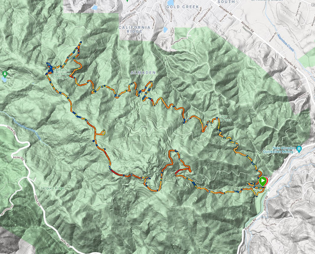 |
| My hike as captured by my GPS |
On a cool, overcast morning I begun my hike at the Hacienda entrance, going up Mine Hill Rd.

I've been up this trail many times before and even posted about it here. I already knew the sights there well and I had a good idea of what wildflowers I'd see growing along it. Sure enough, I saw a nice field of lupine on the hillside right of the trail.
 |
| Lupine, Lupinus sp. |
There was a movement up slope just below the oaks. A deer. It looked at me me briefly then slinked away into the brush.

Morning glory, one of the later-blooming species, marked my way up with its large, white-glowing flowers. Despite the clouds the flowers were fully open, as if anticipating the lated burning of the fog.
 |
| Western Morning Glogy, Calystegia purpurata |
Another very common wildflower along the trail was the pacific pea, a nice, lilac-colored legume that likes the forest's shade and thrives in the undergrowth.
 |
| Common Pacific Pea, Lathyrus vestitus |
Mine Hill Rd used to be one of the main roads for the mining facilities, and also the main route connecting English Town with San Jose. A few abandoned vehicles, now old and rusty, can be seen down the hill slope from the trail, half or almost completely buried in the soil with vegetation growing on and around them. I have posted photos of these old cars as well as view photos from Mine Hill Rd on my previous blogpost on Almaden Quicksilver Park.
 |
| Mine Hill Road |
Poison oak is prevalent along the Almaden Quicksilver trails. I hardly photograph it anymore. I just notice it and avoid touching it. Except when it is decorated with blooming clematis, of course.
 |
| Clematis sp. and Poison Oak, Toxicodendron diversilobum |
There were different colors on the more open, less shaded parts of the trail. Indian paintbrush- another later bloomer species dotted the hillside with red.
 |
| Indian Paintbrush, Castilleja affinis |
Little by little the clouds started to break and the day became brighter. I was very glad to see the globe lilies by the trailside. There were many of them, too.
 |
| White Globe Lily, Calochortus albus |
I turned right on Randol Trail, which is level for a good distance. This trail runs generally east-west. It is on a north-facing slope and os very well shaded. It also offers some really nice views of the Santa Clara Valley, aka Silicon Valley.
 |
| Randol Trail |
In the shade of the forest I saw some Indian warrior flowers. It surprised me - these are of the early bloomers and are usually done by the end of April, yet those I've seen there were at their peak bloom.
 |
| Indian Warrior, Pedicularis densiflora |
In a short time I reached the Day Tunnel site, where there used to be one of the cinnabar mining tunnels and a drainage of flood water from the mine. The tunnel s blocked today but the water still seeps out of it into a small pond where the local newts come to mate and lay their eggs in the winter.
 |
| The pond at the Day Tunnel site |
When I hike the shorter loop trail I turn left from the Day Tunnel to get directly to the English Town site. This time I was walking the long way round, so I continued on westward on the Randol Trail. As I was making my way beyond the Day Tunnel site I saw a pair of California quail roaming on the trail. They kept scooting away as I approached, and eventually slipped off into the vegetation, so I didn't get a good photo of them.
 |
| Randol Trail |
It was along the Randol Trail that I saw the first iris blooming. After that I saw many more of them on the hike.
 |
| Fernald's Iris, Iris fernaldii |
Shortly after I made a surprising encounter - a sole California newt, all alone, on the dry trail. It seemed healthy and alert so I assumed it was just making its way from one place to another. I'm not used to seeing them so exposed and on dry earth, though.
 |
| California Newt |
Randol Trail makes a detour to the north, going by one of the more recent mining shafts. There is a shortcut which I later took while leading the family group, but on this hike I went down Randol Trail to take a look at the shaft's remains.
 |
| The Randol Trail detour |
On the way there I got to see some collinsia flowers. There were few of them in that location, a bit unusual for a species that usually carpets entire slopes.
 |
| Chinese Houses, Collinsia sp. |
I sat down for a short snack break on one of the cement blocks, the only above-ground remains of the mining shaft. The site was another scar on the beautiful terrain here, a leftover mark of people who came to take what they wanted, then left damage and ugliness behind. From an historic point of view it is interesting, but I ended up not leading my family hiking group there.
 |
| Buena Vista Shaft |
I reconnected with the Randol Trail and continued on westward. The day was getting hot and I welcomed every bit of shade along the way. This usually came in the shape of thin-canopied live oak trees.
 |
| Randol Trail |
Although the Randol Trail is on the north-facing side of the mountain, it meanders so much that it has segments that face nearly every direction. West of the mining shaft I had visited, the majority of the Randol Trail is exposed to full sun (now that the fog has lifted completely). In accordance, I saw a very different slew of wildflowers on that part of my hike.
 |
| Sticky Monkeyflower, Diplacus aurantiacus |
It was there that I started seeing another species of the morning glory, one that's more common in open, exposed areas in the Bay Area hills.
 |
| Hill Morning Glory, Calystegia subacaulis |
Randol Trail is one of the longer (if not the longest) trail in Almaden Quicksilver Park. More than a third of my hike was on this trail, yet the scenery and variety of sights and plant life along it was simply wonderful to see. Having had more time I would have hiked its entire length. Maybe one day I will.
 |
| Randol Trail |
As it was, I needed to turn uphill to start looping back. I planned to do so at the Prospect #3 trail which I was coming to soon, but right at that trail junction there was another trail, a short one, leading to a vista point at the edge of the hill, looking east. Naturally, I had to go and check it out. There was a picnic table at the vista point, which wasn't visible from the Randol Trail, and also a staggering view of the Santa Clara Valley and the Diablo Range of the East Bay. Floating on the remnants of the morning's clouds was the peak of Mount Hamilton, easily recognizable by the white domes of the Lick Observatory on its summit.
 |
| Mount Hamilton |
I marked this point as a place to have lunch break when I'd bring over the hiking group, then I turned around and started going up Prospect #3 Trail.
 |
| Prospect #3 Trail |
Prospect #3 Trail is a narrow foot path, one of the few that connects the wide dirt road that is Randol Trail with the wide dirt road that is Mine Hill Road, which runs higher along the ridge of the hill. It is much less used than the main trail. Theoretically that means more chance of encountering wildlife. In reality I didn't see all that many, and all of them were either elusive birds or invertebrates.
 |
| Trap Spider holes |
Plant life was a different matter altogether. On that trail I saw the fritilaries in bloom, which was very exciting.
 |
| Checker Lily, Fritilaria affinis |
Except for the bottom part, Prospect #3 Trail was mostly shaded, tucked deep within the vegetation. It was a nice relief from the day's heat, especially on the uphill grade.
 |
| Prospect #3 Trail |
The moment I connected with the Mine Hill Road I had to stop and gasp: on the other side of the mountain, across the deep valley towered Mount Umunhum, crowned by the old Air Force radar building, a landmark seen from far and wide.
 |
| Mt Umunhum |
Mine Hill Road is also one of the longer (perhaps the longest) trails in this park. I started hiking on it, going uphill from the Hacienda entrance, then left it to go on the Randol Trail. Now I was back on Mine Hill Road, up on the ridge, going east. There were much fewer trees along this part of the trail, and since it was about midday, there was also hardly any shade.
 |
| Mine Hill Rd |
Thick cushions of hairy vetch decorated the side of the trail. Hairy vetch is one of the most aggressive invasive species in California. I don't normally photograph it. The intense color however, did win me over this time.
 |
| Hairy Vetch, Vicia villosa Non-native, invasive. |
The high part of Mine Hill Road follows the ridgeline, which means it isn't flat, yet the elevation changes are fairly mild and walking down that trail was easy and I made good progress, enjoying sweeping views all around.
 |
| Mine Hill Rd |
I was making my way uphill and just before entering a forested segment of the trail I saw on the side, on a thin-soil area of exposed land a patch of wild onions.
 |
| Jeweled Onion, Allium serra |
I took some quick photos of the onions and was about to move on when I noticed a pretty plantago plant right on the trail next to the onions. Most plantains that I see are non-native and not very pretty either. This one looked nice so I photographed it too and moved on. Late I found out that this plant is one of the few native plantain species and I was glad to have not dismissed it as uninteresting.
 |
| California Plantain, Plantago erecta |
I was happy to get in the shade, but it didn't last very long. The forested area that the trail went through wasn't very big and soon I exited the tunnel of trees on the other side. There, however, another type of tunnel was waiting for me to check out.
 |
| Mine Hill Rd |
I remembered having seen this feature before, arriving to it from the other direction on another hike, a few years ago. Then I was pressed for time and didn't stay very long but this time I approached the tunnel to check it out. The Catherine Tunnel is man-made but I'm not sure it was a mercury-mining tunnel. There isn't a trail on the other side so I don't think it was a connector of any sort. I wonder what it was used for.
 |
| Catherine Tunnel |
I did go through the tunnel to the other side, and I saw a madrone tree in full bloom- a very pretty sight!
 |
| Pacific Madrone, Arbutus menziesii |
I also had a great view to the northeast, of the Santa Clara Valley, aka the Silicon Valley. Aware of the stellar view from this point, the park's authorities installed a bench there. The bench cannot be seen from the other side of the tunnel and those who sit there are guaranteed privacy (or a surprise if someone sneecks up on them unawares.
 |
| Santa Clara Valley, aka Silicon Valley |
There is also a narrow bypass trail around the tunnel and I used it to get back to Mine Hill Road. A short distance after I was facing a choice - to continue on Mine Hill Road to English Town and head directly down from there or to continue in Castillero Trail and explore a bit more of the park before hitting the ghost town. I chose the latter.
 |
| Castillero Trail |
That choice proved to be a good one. Castillero Trail, named after the fellow who first identified the mercury deposit in this place, has some awesome views to the southwest, including another view angle of Mount Umunhum.
 |
| Mt Umunhum |
There were also many California poppies blooming along that trail, making beautiful color combination with other wildflowers.
 |
| California Poppy, Eschscholzia californica, and Blue Dicks, Dichelostemma capitatum |
Castillero Trail goes by the old site of Spanish Camp where the laborers of the mining company used to live/ It also goes by the rotary furnace site which was the more modern facility where mercury was released from the cinnabar-containing rocks.
 |
| Rotary Furnace |
Naturally I had to go down to the furnace and take a closer look. On the way there I also spotted a blooming elderberry tree which is always a lovely thing to see.
 |
| Black Elderberry, Sambucus nigra |
The rotary furnace was left unsalvaged and is mostly intact, albeit rusty and in eaten by time. The structure is fenced off so I couldn't get close to it, but I did manage to hold my camera lens at the fence in a way that the fence wire doesn't show.

Winged creatures don't mind that fence, of course. I was focused on the scrub jay that perched on an abandoned piece of machinery when a turkey vulture entered the picture frame. It was far from the jay and the smaller bird didn't react at all to its presence, or to my attention.
 |
| A Scrub Jay and a Turkey Vulture |
After checking out the rotary furnace I went back fo Castillero Trail and from there I turned onto the Yellow Kid Trail, which leads to English town. The Yellow Kid Trail is named after the messenger service that used a logo of a blonde Irish child carrying a mail bag.
 |
| Yellow Kid Trail |
The manroot vine, an early bloomer, was fruiting at he time of my hike. The thorny fruit was well hidden in the foliage, tucked away from would-be foragers.
 |
| California Manroot, Marah fabacea |
Along that trail I also found the California gilia, another wildflower that is unassuming and easy to pass by but it's nice not too because it is very delicately beautiful.
 |
| California Gilia, Gilia achilleifolia |
I took my final break in English Town, which hasn't been populated since the Quicksilver Mining Company had ceased its operation of the New Almaden mine. Since all the residences there were leased from the company to begin with, the town's inhabitants simply moved away and left the town to crumble and become a ghost town.
 |
| English Town site |
From English Town I headed back down via the Deep Gulch Trail, which is the trail I usually come down on on my hikes in Almaden Quicksilver Park. I know this part of the trail very well, vell enoug to know which plant blooms where. I don;t post many photos of this trail here because I already posted about it in the past, and this blogpost is already quite heavy. I did add the blooming salfry here because I never posted it before - it too is a common invasive species, but a pretty one.
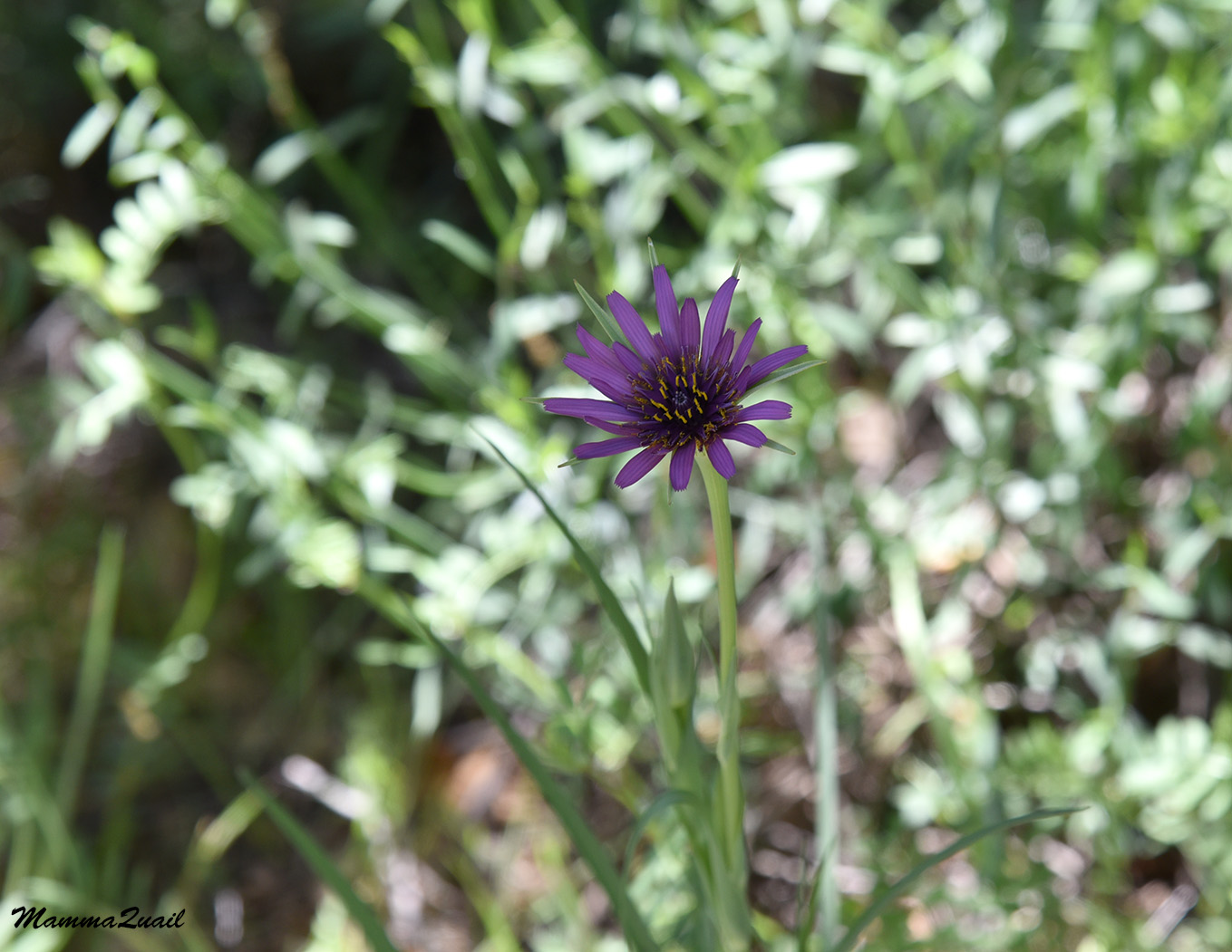 |
| Salsify, Tragopogon porrifolius |
I also couldn't resist another photo pf the larkspur blooming near the bottom of the Deep Gulch Trail. There's a nicve patch of them there and I expect to see them when I come around the rocky corner at that spot.
 |
| Larkspur, Delphinium decorum |
At the very end of the trail, right before it opens into the great big lawn with the educative display of mining machinery (photo in the header) there's an exposed rock face showing beautiful layers, none of which is cinnabar but they are gorgeous nonetheless.

Almaden Quicksilver is one of my favorite places to hike. It has rich nature and a fascinating history. I also love taking others to hike there, and indeed, the family hike that I led there a few weeks later was a very enjoyable one. So far I have only explored the eastern side of the park but there's a lot more to see on the western side, and I hope to get there in the near future too.