Address: 680 Point Lobos Ave. San Francisco
Level: easy
The county of San Francisco is all city. Here and there, however, there was left an undeveloped area with an almost wild feel to it. One such place is Land's End, today a part of the Golden Fate National Recreation Area.
While Land's End isn't on the absolute must see list of SF tourists, it still attracts many people, and often it is difficult to find a parking spot at the main lot by the visitor center.
Up until the date of this hike I, like many other visitors, was satisfied with viewing at the ruins of Sutro Baths, and enjoying the beach below.
 |
| View of the Sutra Baths |
The green cliff area however, beaconed me, so I added it to my hiking wish list and eventually to the Redwood 4-H Hiking Project schedule. The photos here are from my solo preparation hike and the following 4-H hike.
Awareness of the California native nature has increased in recent years, and with it the efforts to preserve and also rehabilitate the native vegetation in many places. A good job of that was done at the
Lobos Dunes of the neighboring Presidio of which I posted here before.
The area near Land's End visitor center has been repopulated with native coastal plants, some of them were even blooming.
 |
Seaside Fleabane, Erigeron glaucus
|
A wide path meandered between the coastal bushes and I walked slowly along it, paying attention to the new growth and the beautiful colors. On the day of my solo hike the parking lot was nearly full yet the trail was almost deserted. On the day of the group hike the lot was surprisingly vacant, yet the trail was full with bikers, joggers, and some hikers too. I presume that at no time this place would be found human-free.
 |
| Common Yarrow, Achillea millefolium |
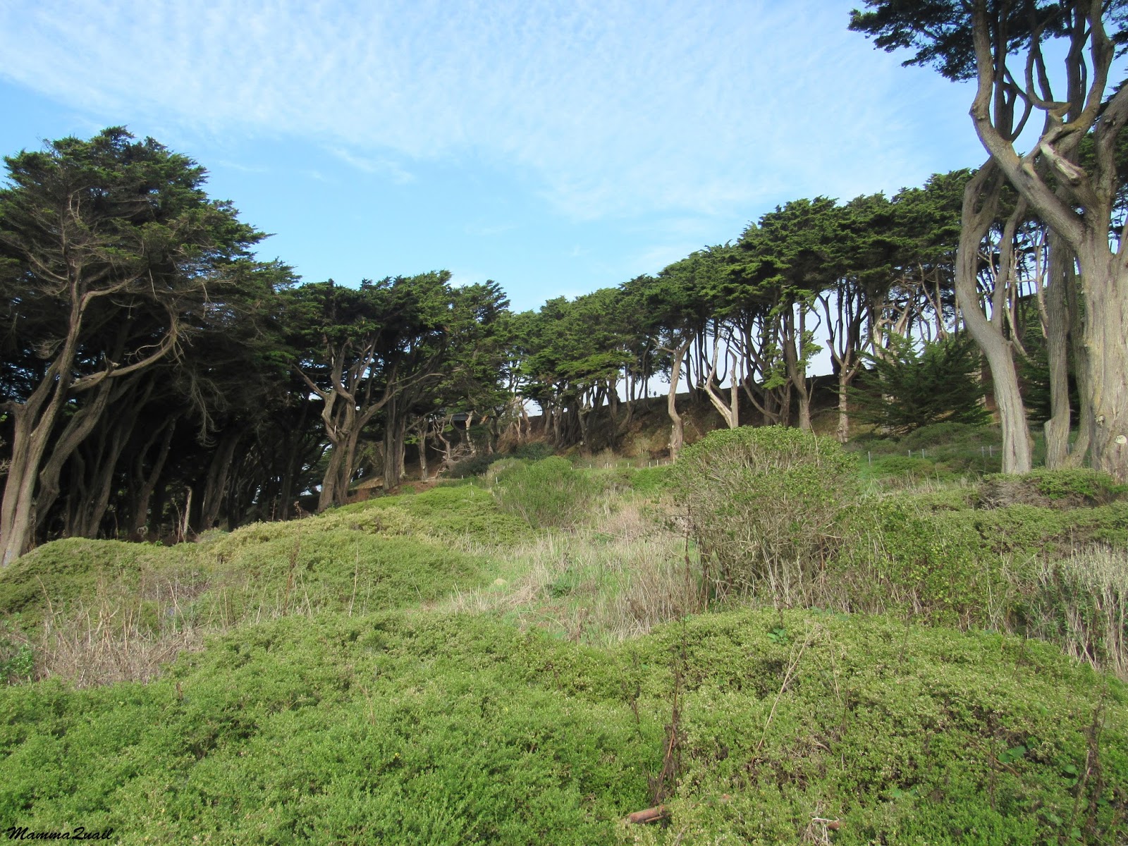
Above the parking lot the path becomes a trail that stretches northward through a lovely grove of cypress trees.
I spotted a hawk perched on a brach of one of these trees and pointed it to the group. Both Pappa Quail and my elder chika trained their camera at the bird. It didn't seem to mind one bit.
 |
| Cooper's Hawk |
In the nearby bushes Pappa Quail had spotted a towhee.
 |
| Orange Moon |
Further down the trail there is a staircase leading upward, connecting to a higher trail through the park. Between the stairs and that trail there is another parking lot and south of it a memorial to the USS San Francisco - a battle ship that fought and was damaged during WWII.
 |
| The USS San Francisco Memorial |
Many sparrows were active all around me. some were hopping on the cement ledges. I saw one sunning itself, looking nonchalantly at the passers by.
 |
| White-crowned Sparrow |
The view form up there was spectacular. Partially overcast on my solo hike but I could still see a long way out.
After admiring the USS San Francisco memorial I found the upper trail at the edge of the parking lot and commenced walking, now east bound. Before long I was engulfed in vegetation. The sound of the crashing waves below drowned the sounds of the city above and like by magic, I felt like I was out in the wilderness, away from society.
But not far enough from al the escaped cultivars that populate this park. Many of the plants I saw there were immigrants, brought from overseas to the yards and gardens of the city. Some just took off and set their roots out in the wild.
 |
| Plume Acacia, Albizia lophantha |
They were all very pretty. It was easy to see why these plants were introduced into gardens here. Still, in gardens they didn't remain confined. California's climate is very welcoming.
 |
Passiflora tarminiana
|
While these pretty garden plants do catch the eye, there were plenty of California native plants still to give a wild appearance to Land's End. During my solo hike I had an easy time taking trail photos that didn't include any people. It was easy to forget that the city was just a few yards away.
Wildlife too we encountered on this hike. Birds, mainly.
 |
| Anna's Hummingbird, male |
But also other creatures.
 |
Banana Slug
|
Nearing the eastern end of Land's End the trail changes altitude, going up and down with many stairs. I took it slowly, stopping to breath and to admire the fresh, green ferns that were growing on the thin topsoil that covered the rocks.
At that part of the hike the trail is a bit more inland and not right over the cliffs. But I did get occasional glimpses of the ocean. And then I had a peep of the Golden Gate Bridge, making sure I would not forget where I was :-)
There too were areas of native vegetation rehabilitation. The blood currant was in bloom, just as pretty as any of the imported garden plants. Indeed, it is now used to beautify many a California yard, including my own.
 |
| Blood Currant, Ribes sanguineum |
Eventually I emerged at the north side of the park, where the trail once again goes right over the coastal cliffs and a nicely landscaped vista point with an observation platform and benches, and a terrific view of San Francisco's iconic landmark.
There was also a view of the neighborhood that's between the Presidio and Land's End, and beyond it in the background sticks up the new monster skyscraper in downtown San Francisco.
While I was admiring the geographical features Pappa Quail was looking for birds. And he found many of them, ocean side.
 |
| Glaucus-winged Gull |
And right over the water, gliding through the spray.
 |
| Western Gull |
This place is truly a birder's heaven. On my solo hike I've met a few near the Sutro Baths. For the group hike I brought two of my own :-)
 |
| Surf Scotter, male |
Pappa Quail also aimed his camera at the Golden Gate Bridge, but as it turned out, it was the bird he was looking at. A beautiful red-tailed hawk was suspended in mid-air, balanced on the wind without flapping a wing.
 |
| Red-tailed Hawk |
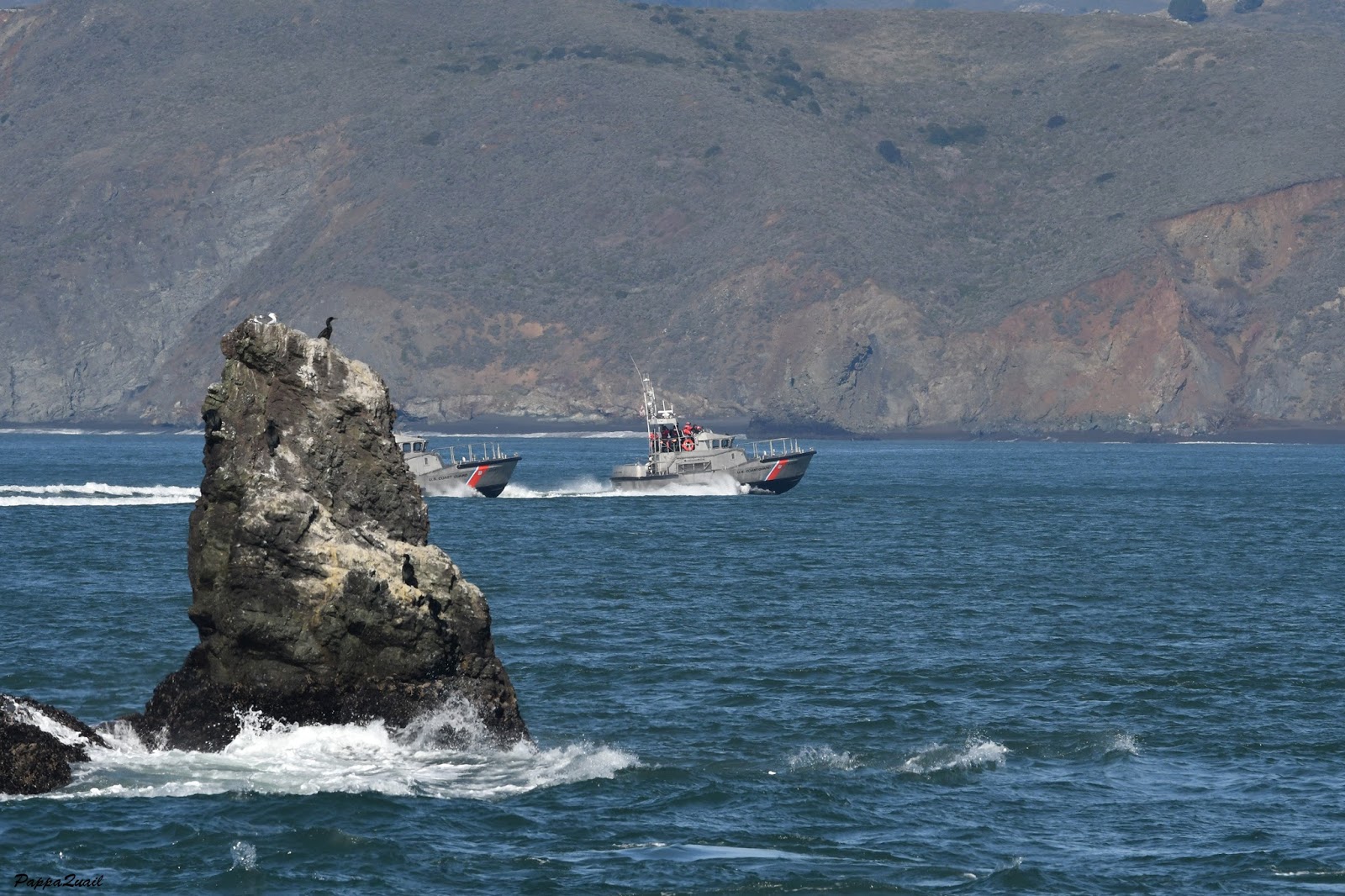
Pappa Quail also captured some niece close ups of the cormorants on the rock, but I liked this image of the boats cruising to the Golden Gate.
From the north end of Land's End we took the sidewalk up along El Camino Del Mar, the road that will eventually bring us back to the upper trail. It was a bit unusual to have our hike turn into a city walk but that was the quickest way up and back on our planned loop trail. And it too provided some interesting sights. Like this bump I thought was a bird on the lower branch of this tree below. (A close up revealed it to be the stump of a branch.)
 |
| Yes, I fell for it. |
San Francisco is a city of monuments. Sure enough there were plenty of monuments to see along the way. I liked this one - a monument for peace inscribed in Japanese with translation to English on the side. During the group hike all the children gathered around the inscribed stone, admiring its smooth and graceful appearance.
 |
| Monument for Peace |
We moved quickly on the sidewalk until we reached the Legion of Honor where we reconnected with our park trail. At first, however, we had to cross the park's golf course.
 |
| It's nice to see green in winter. It would hurt in summer. Either way, this isn't public grass to run and roll on. |
We crossed the golf course, found the trail connector, and went right away to the lower trail. Turned west and found the steep, multi-steps path to Mile Rock Beach.
On my solo hike I didn't go all the way down to the beach itself, but enjoyed the nice coastal sight from above. There were very few people there and the sound of the sound of the waves drowned all other sounds.
On the group hike I had to exercise my will to get the children to the labyrinth first but after that we all went down and enjoyed a good time at the beach among a gazillion other people. The waves were higher and stronger but the dominant sound was that of humans talking, shouting, and laughing.
 |
| Mile Rock Beach |
Just above the beach, at the end of a little side trail, was another monument - an unofficial one - the Labyrinth of Land's End.
The first time I encountered a labyrinth of this type was during my hike at
Sibley Volcanic Regional Park. Later I have found the one at the top of
Mori Point, along with its numerous (and still multiplying) little 'offsprings'. When I learned that Land's End has one I had to include it in my hike plan, and I wasn't disappointed.
Built by the artist Eduardo Aguilera, this labyrinth is much more interesting and complex than the simple spirals laid out in other places. It has become a well loved landmark and its location is prime, no doubt. It was almost impossible for me to get a people-free photo of this monument.
I prompted all the 4H hikers to go through the labyrinth. Meanwhile I scouted the horizon. I didn't see any whales that day, but it was impossible to ignore the huge liner that was making its way slowly to the mouth of the Golden Gate.
 |
| What goods do you bring from far away? |
We had a good time at the beach and I wish we could have stayed more, but eventually it was time to move on. With some effort I managed to gather everyone and urge them up the stairs and back on the trail.
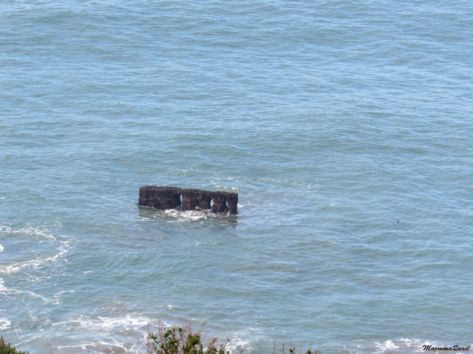
We continued west on the lower trail. For some time we were once again walking in an almost wild setting but soon the path widened and became paved. We reached the cemented vista point just below the stairs leading to the USS San Francisco Memorial. Below, just off shore were the remains of an old shipwreck, sticking out of the water.
I looked back east. There was the Golden Gate, and the magnificent bridge in full view. I took yet another photo of this iconic sight (heading this post). Then I turned my attention to the place we just left - the rock ledge over Mile Rock Beach, and the labyrinth. A fitting landmark for San Francisco, more moving than any of its official monuments.
From there, it was a matter of five minutes walk back to the visitor center and the parking lot. Any thoughts I had of going down to the beach by the Sutro Baths were dismissed - the children had already their beach time and were ready to go home. None of us had any thoughts of remaining in the City for further exploration that day.
This loop trail is fairly short and can be walked quickly if fitness is the only thing on one's mind. Taking the time, however, is very rewarding because a large art of this trail still has a very wild feel to it, and provides wonderful opportunities to immerse in Nature. In an urban block such as San Francisco, that is priceless.