Friday, June 21, 2013

Between Seasons at Trinity Alps: Rain on the Trail to Boulder Lakes


Date: May 25, 2013
Place: The Trinity Alps, Trinity Center, California
Coordinates: 41.065365, -122.783185
Length: Both lakes in and out, about 4.5 miles.
Difficulty: Moderate to strenuous.

Getting to Boulder Lakes trailhead requires a 7-mile drive on unpaved dirt road. It is passable for non AWD cars but does have some challenging places along the way and requires careful and slow driving. It took us about an hour to get from the campsite to the trailhead. 
This trail is within the Shasta-Trinity National Forest. The NF map is of too small a scale to be of any use in navigation. We had, in planning, acquired USGS topographic maps of the areas where we planned our hiking, and such was the map we used. The trail, as we found out, is obvious and well marked, and there was no need for any map consultation. 
The trail is nice and wide in the beginning. There are many shrubs and bushes along the trail and most of them were in full bloom. This one I liked most: it looks like a little ornamented tree.
Ribes roezlii
It was overcast and the cloud cover grew darker with each step, but we went on. The trail descends slowly through the forest and the shrubbery. We didn't see many anumals. Just some chipmunks here and there. This one posed for Papa Quail:

The Trinity Alps are carved from a mass of igneous rock that's different in origin from the coastal range. Weathering shaped it into ragged peaks that loom above the forest, threatening and alluring.

These peaks are popular among mountaineers and I could only wish I was one of them. Maybe in the future, when the chikas grow up.

The chikas started the hike somewhat reluctantly, but got very excited when we arrived Boulder Lake. We had encountered there a group of people, one of which was busy fishing. He offered the chikas to try casting and they were very excited to do so.
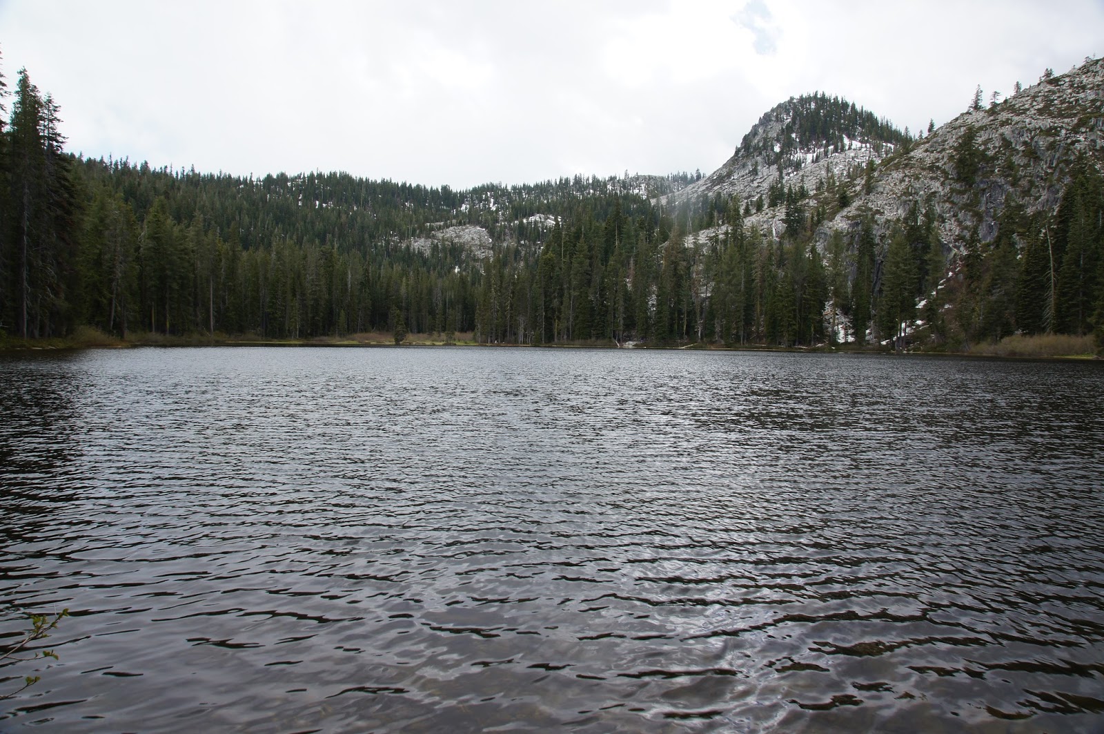
Boulder Lake
The people we met at Boulder Lake were getting ready to leave quickly, and their reason hit our heads soon enough: rain.
They did recommend us not to skip Little Boulder Lake though, so we walked back up on the trail and by the time we arrived at the branching of the trail to Little Boulder Lake the rain had ceased, to we took the advice and turned on that trail.
While the trail to Boulder Lake is relatively mild grade, going to Little Boulder Lake involves a steeper ascend. It didn't help the general mood of Papa Quail and the chikas when the rain returned, and stronger. We didn't bring any rain gear on the trail with us so I had to shove my camera down my shirt to protect it, taking it out only for quick shots.
Rain on Little Boulder Lake
Right by the trail were evidence of the not so long ago winter: snow patches on the ground.
Little Boulder Lake
We looked at the lake for maybe five minutes then hurried right back under the May shower. A few minutes after we left the lake the rain stopped completely and the clouds separated.


And the blue sky appeared! 

And I could take my camera out of hiding once more and photograph the pretty Manzanita flowers.
Manzanita sp.
Actually, we didn't get all that wet. The rain wasn't strong enough to discourage me but the rest of the Quails decided it was time to go back to the campground and make dinner.
I didn't make it easy for them, though. There were so many beautiful flowers along the dirt road that I stopped the car frequently and got out to photograph them. I was particularly impressed by the Pacific Dogwood that reminded me of brides and wedding decorations:
Pacific Dogwood (Cornus nuttallii)

It's even more beautiful from up close:


Ans the Beargrass, which lighted up the roadside with its incredible inflorescence torches: 
Common Beargrass (Xerophyllum tenax)
But one time it was Papa Quail who stopped the car. He saw a movement in the trees and went out to explore. It turned out to be a woodpecker of a species we've never encountered before: 
Hairy Woodpecker
So we didn't make it back to the campground too early after all. The campground, being in lower elevation, was completely dry. By the time we finished our dinner it was almost dark. Although the trail  we did was not too challenging, we were all ready for the sack. 


Thursday, June 13, 2013

Camping by Trinity River

Date: May 25-27, 2013
Place: Trinity River Campground, Shasta-Trinity National Forest, California
Coordinates: 41.10844, -122.70617

For a long time I would stare at this region of the California map and dream. This time it was coming true. This past Memorial Day weekend we went hiking at the Trinity Alps.  Doing so, we also entered Trinity County, the last remaining California county in which we'd never before set foot.
This post is just a short one about our camping experience at the Trinity River campground, which was our base camp for the hikes we did in the area on that weekend.
Trinity Lake
Trinity Lake, is the northwest part of Shasta-Trinity lakes system. It is in the area of the Shasta-Trinity National Forest and it is a popular recreation area. Most resorts and campgrounds are right at the lake shores. Because I selected our destination only a week before, every campsite that could be reserved was already reserved. Our choice, therefore, was limited to the first come first serve campgrounds. I originally chose the Goldfield campground by the Coffee Creek Road, but when we arrived at the area on noon Saturday, Papa Quail suggested we try for the Trinity River campground.
Trinity River, north view
The Trinity River feeds into Trinity Lake. The campground is a few miles north of the lake, right by Hwy 3. I was concerned about traffic noise but that was not a problem.
There was only one occupied site when we arrived and by the time it took us to build our tent they were already packing theirs. We had the campground to ourselves and we had the choice of the best site: right by the river.
Trinity River, south view
The reason Papa Quail favored the Trinity River Campground was that at the Shasta-Trinity National Forest website it is said to have potable water (and as of writing these words, this information is still not updated). It was only after we pitched our tent that we discovered that the water has been disconnected a couple of weeks before our arrival. We had, however, our 7 gallon container, which we filled with drinking water at the visitor center, and the Trinity River provided for all of our washing needs.
So we stayed.
Darmera peltata, on the river bank.
Camping at Trinity River Campground was fantastic. On our first night there, there were only two other campers, both on the other end of the campground. On our second night, we were completely alone. There was no traffic at all during the night. No sounds of talking, singing, fighting or RV generators. The only noise was the the river water, running along. A very soothing sound.
There were no lights. The moon was almost full, but a thick cloud cover darkened it. There were no other campfires, no electric lights on all night at the toilets, no vehicle headlights passing randomly along the tent. The moment I quenched the last embers of the campfire and switched off the flashlight I was surrounded with blissful darkness.
And it was not nearly as cold as the weather forecast had said. At least, it didn't feel like it.
Evening falls.
It was my best camping sleep in a very long time. Just as wilderness should be.

We on the Saturday of our arrival we hiked to Boulder Lakes and on Sunday we hiked along the south fork of the Salmon River. I wanted to hike some more on Monday morning but it was raining enough to discourage the rest of the family from any additional hiking in the area. So we broke camp and drove out, stopping only for a quick visit at Crystal Falls by Whiskeytown and a lovely birding walk at the Sacramento NWR. These hike stories will soon be posted separately.
I won't recommend this campground to anyone because I want it all to myself next time ....


Friday, June 7, 2013

A Hidden Treasure: The Carrizo Plain and Soda Lake

Date: January 1, 2013
Place: Carrizo Plain National Monument, San Luis Obispo, California
Coordinates: 35.24169, -119.90700
Difficulty: easy

The morning of the first day of this year was a bit glum for me. We were on our way back home to the Bay Area. Papa Quail was ready to go straight home but I wanted to get just a little bit more nature into our last vacation day. So after some convincing we pointed our car to the Carrizo Plain National Monument, which was on our way. Sort of.
Our first port of call was the Overlook Hill (35.239594, -119.907884). It's very short walk to the top and the view is impressive.  The sheer empty vastness of the place can make one dizzy. The wind was blowing strong and I just felt like flying over and high into the clouds.
The Carrizo Plain is a large basin nestled within the Transverse Ranges in eastern San Luis Obispo County, between the Elkhorn Hills and the Caliente Range. The runoff water from these ranges collect at the bottom of the basin in Soda Lake. Soda Lake is seasonal and, having no outlet, has high salts content. When its water evaporate, a thick salt plain is left behind.
A view from the Overlook Hill to the southeast across Soda Lake
Our second stop, very close to the first, was at the Soda Lake Trail (35.24168, -119.907393). The trail, a little less than a mile in and out took us to the lake  where we could closely observe this fascinating habitat, look at the vegetation and look for birds.
Alkali shrubs and weeds grow on the salt-crusted plain surrounding the lake
We were there at the dead of winter and the place bore no resemblance to the lovely pictures of colorful pastures of wildflowers that I saw on the monument's website.
The bleak grayness was broken by the birds. There were many little birds chirping happily all over the place. Mostly sparrows. Some of them of species we have never encountered before. Big check mark for Papa Quail :-) 
Sage Sparrow
Here's a bug eater: the Loggerhead Shrike. It also catches larger pray such as lizards and impales them on thorns.
Loggerhead Shrike
A splash of bright color: the bright yellow Meadowlark. It is quite difficult to photograph these birds in a shrubby area. They don't like to be exposed for long.
Western Meadowlark
The Soda Lake of Carrizo Plain is an alkali wetland, one of the few in California that's left in natural condition. Its water support brine shrimp which in turn support the bird population there, both regular and migrant.
The salt crust left after the lake water evaporated.
The area is managed by the Bureau of Land Management and at their web site there is a warning to visitors not to rely on satellite navigators. I totally agree with that - heed this warning! better to rely on updated paper map and, unless you have a high clearance AWD, stick to the main road.
We didn't know that at the time (and even if we did I'm not sure it would have stopped us from trying), so we headed along a dirt road (subject to flooding) with our 2WD to the northeastern area of the plain.
There was a flooded area near the path, but the road itself was dry.
Reflections along the road. In the background: the Elkhorn Hills.
Our third and final stop was at the Wallace Creek Trail (35.267494,-119.827143). There Papa Quail photographed this cute sparrow:
White-crowned Sparrow
The Carrizo Plain is another place ripped by the San Andreas Fault. Wallace Creek os offset to the fault and information boards along the trail explain the geological history of the area.
A view of Wallace Creek
There, at the top of the hill that overlooks the creek, Papa Quail met another new one (for us): The Lark Sparrow. Later he also spotted a roadrunner that was a bit too quick to be in focus. By the time I got my eyes to the place where he was pointing too there was only a cottontail rabbit there, running quickly away.
Lark Sparrow
The squirrels, however, didn't run away.
Nelson's Antelope Squirrel
This trail is also pretty short. It doesn't end anywhere, just sort of disappears. At that point the chikas, who were at the end of a long road trip, were also at the end of their tether. We turned about and headed back to the car, stopping to photograph the only plant we saw that was actually flowering: a Milk Vetch, which turned out to be a pretty rare one.
Salinas Milk Vetch (Astragalus macrodon)
On our way out we saw this raptor hovering above us. Papa Quail was quick to pull his camera and scored another new one (for us): the Ferruginous Hawk.
Ferruginous Hawk
This brief visit to the Carrizo Plain National Monument was our concluding hike of our big desert winter vacation, during which we've been to places we've never seen before and seen many birds we've never seen before, and imbibed in the beauty and splendor of the Southern California deserts.
And also the Bighorn Sheep :-) 


Sunday, June 2, 2013

Winter and Spring at The Big Morongo Canyon Preserve

Dates: December 13, 2012 and March 13, 2013
Place: Big Morongo Canyon Preserve, Morongo Valley, California
Coordinates: 34.0504, -116.5698
Difficulty:  West Canyon and Yucca Ridge trails are moderate. Everything else: easy.

The Big Morongo Canyon Preserve is one of the places we found out about by having some time to check out a green spot on our road map. Is was close to our way north and we had the time so there we went.
The preserve isn't large and the entire trail system can be easily done in a short time. The thing is, though, it is far better to take it slow, because then one gets to see what's growing there. On our December visit we spent about three hours in the preserve and in that time walked all the loops except for the Yucca Ridge Trail.

The map is downloaded from the Big Morongo Canyon Preserve site.

We were there on the last day of the year, that is, in the dead of winter. Except for the conifers, all the trees were naked. We didn't expect to see any wildflowers at that time of year and indeed, there were none. Even the shrubs looked still and dry.

It was nice to walk around and take in the scenery. It was fairly cold when we started, but the sky was clear and the sun soon made us take our jackets off.
The different loop trails go through a number of different sections, including low brush, forest, marsh, the canyon itself and the hills above. Each of these sections is a different habitat and walking through all of them is getting to know and appreciate the diversity that can exist in a single, fairly small area.
A pair of Yucca on the hill. 
Big Morongo Canyon is nestled between sedimentary hills that border Joshua Tree National Park from the northwest. While the hills themselves are dotted with low shrubs, the canyon itself is thickly forested.

There is water in Big Morongo Canyon. Spring water that sustain all the canyon vegetation. Tall trees and all.
We've also seen the remains of a fire that was there some time ago. Many burnt trees were standing or lying fallen along the Desert Willow Trail.

This preserve is a home for numerous bird species and a stopping point for many more migrating ones. It was the birds that we were looking for, but it was not a good time to see the migratory species and the locals didn't readily present themselves.
California Towhee standing on the remains of a burnt tree. 
We kept on walking, looking for the birds. It was on the last loop we did: the West Canyon Trail, that we saw a group of bluebirds hopping and chirping happily on the hillside.
Western Bluebird
At that point we were in some hurry. The sun was setting and we still had quite a bit of driving to do. We were headed to the town of Mojave were we would stay for the last night of our winter vacation.
Sunset light in the trees at The Big Morongo Canyon Preserve
I was fortunate to return to Big Morongo Canyon Preserve a couple of months later, this time with my botanist friend. although spring was just in the beginning, the transformation was very impressive. All the photos below were taken on March 13, less than three months after my winter visit there.
A Western Side-bloched lizard , basking in the late morning sun
We arrived at Big Morongo Canyon at the end of a cold wave, looking for spring wildflowers. We were lucky to have started our hike at the hillside of the West Canyon Trail (wanted to see if the bluebirds were still there. They weren't.) because that's where the flowers were.
Suncup (Camissonia pallida)
There were not many, and all of them very small. But still, lovely dots of lively color on the bare desert ground.
Mojave Lupine (Lupinus soarsiflorus)
And we ere happy to see them all.
A mat of tiny poppies between bare shrubs
The trees were a different story. All the deciduous trees that were bare two months before were now bursting in lively flames of bright greens.
Budding trees in the Big Morongo Canyon
Coming down into the marsh area of the preserve we saw no more flowers, just a lot of green vegetation. We did get to see all those birds that eluded us during our winter visit :-)
Nuttall's Woodpecker, female
The tiniest of them:
Costa's Hummingbird, male
And the awe-striking raptors too:
Sharp-shinned Hawk
The amazing change I've seen in this place in less than three month has once again reinforced my desire to  revisit the same places, because each time its like being the first time there.

Being so close to the famous Joshua Tree National Park this little preserve might be overlooked by most visitors of the region. I would strongly recommend visiting there. But then again, it might be just for the best to not overrun the place with too many people.

Many thanks to Papa Quail for his help in identifying the birds, to my friend עננת for identifying the lizard, and to members of the California Native Plants Society for their help in identifying plants!