Wednesday, May 31, 2023

Catching the End of Season at the North Table Mountain Preserve


Date: May 27, 2023
Place: North Table Mountain Preserve, Oroville, California
Coordinates: 39.596029, -121.541825
Length: 2 miles in and out 
Level: easy on top, moderate with the base of the waterfall
 

Last weekend Pappa Quail and I had the opportunity to go away for the weekend, just the two of us. Pappa Quail was too busy to weigh in on the planning and so I chose to go to Oroville, hoping to see some wildflowers there. The North Table Mountain Preserve is one of the best hotspots for wildflowers in California. The photos I've seen posted by others on this superbloom spring were absolutely spectacular. Not only that, but the waterfalls were running high and strong. Now, peak bloom there is in early to mid-April and the end of May is way too late to see either superbloom or waterfalls. I knew all that of course, but I didn't get the chance to go there in season, and I hoped that I could see some leftover bloom after the wet winter we've had.

I remembered having seen on my previous trip there mariposa lilies blooming by the roadside near the trailhead. My hope increased when I saw that they were blooming still on this trip. We didn't stop by the lilies on the way to the trailhead. This photo is from the way back after the hike).

Yellow Mariposa, Calochortus luteus

When we neared the preserve I sighed. Most of the table mountain top was already bone dry. Some greenery remained in the are of the trailhead near the giant oak tree. There was a patch of yellow flowers in the center of the green mat. It was the sight of spring hanging on for just a little longer.
Near the trailhead
 
Right by the trailhead there is a huge oak tree. As soon as we started down the trail Pappa Quail saw a few little birds flying into the tree and stopped. I walked further down the trail to the yellow patch and found that it was of mainly yellow monkeyflowers - a very water loving plant. In between the monkeyflowers were other wildflowers, mostly the modest variegated clover. Underneath the plants the earth was moist - water was still seeping from the earth at that place. 
Seep Monkeyflower. Erythranthe guttata, and Variegated Clover, Trifolium variegatum
 
I waited for Pappa Quail for a few long minutes during which I saw him walk back and forth between the oak tree and the frying grass field on the other side of the trail. Eventually he motioned me to come over and when I did he told me that the little birds that he saw were Lowrence goldfinches, which apparently, are an uncommon sight.
 
He was very pleased to get some nice photographs of these rare goldfinches.  
Lawrence Goldfinches, male (top) and female (bottom)
 
It was late in the afternoon, on the end of our drive from home that we arrived at the North Table Mountain Preserve. It was pretty hot still, and there were only a few other people about. We started down the path along the narrow creek line. 
Our hike as captured by my GPS
 
The creek was well marked with the yellow line of the monkeyflowers, the thin line of surface water shining in the middle. Only a yard away from that life line of water the vegetation was dead and dry and the volcanic rocks bare and baking in the sun. 
 
Well, almost dead and dry. Here and there, I could see on the rocks some annual plants that were still in the process of completing their life cycle, like the jewelflower  that I usually note when it's blooming but is just as fitting its name when it fruits the line of hanging seed pods and the drying round leaves assume the color of gold coins. 
Jewelflower, Streptanthus sp. 

The trail followed closely the thin creek. I was glad to see that it was flowing still, even if a trickle. This creek is fed entirely by the little spring near the trailhead. It also supports that huge old oak there. I assume it dries out at some point. The vegetation near the creek was all green and lush, and looked like as if it never knew drought. Most of of the flowers here too were the monkeyflowers still but other species seemed more and more common the further down the trail we walked.      
Checker Mallow, Sidalcea sp. 
 
In some places the moisture spread somewhat farther away from the thin creek, supporting a wider belt of greenery. The distinct lines of color between the dry and bare to the green and blossom was very clear.

 
We contemplated going to see Phantom Falls, which we never had the chance to see before. Phantom Falls are at the north of the preserve and is the waterfall that usually stars on the online photos of the North Table Mountain Preserve. As we came upon the trail junction however, we met two hikers that were coming back from there. They told us that the waterfall was completely dry and that there was very little bloom left. Pappa Quail and I decided to save that hike for a different trip. Instead, we continued straight to Hollow Falls, where we went on all of our previous visits to the preserve.

 
The little creek and whatever water saved underground supports a few trees along the way. In turn, these trees support wildlife, including birds.   
Ash-throated Flycatcher

While Pappa Quail was looking for the birds I was looking for the flowers. Here and there between all the monkeyflowers I found other species of wild flowers.
White Meadowfoam, Limnanthes alba 
 
The trail isn't long and soon we were at the top of Hollow Falls. The thin trickle of water stretched all the way to the brink so we decided to go down to the base of the fall.

 
The trail down has always been a bit precarious and this time was no different. I walked very carefully on the less than foot-wide path that was at times very close to the precipice. Way below I could see one plant species that was certainly at its peak bloom - the California Buckeye tree. 


Pappa Quail was already descending down while I appreciated the view. When I caught up with him I saw that he was focused on one of the trees near the trail. I waited patiently until he was satisfied with the photos he got of that little brown bird. 

Western Wood Pewee

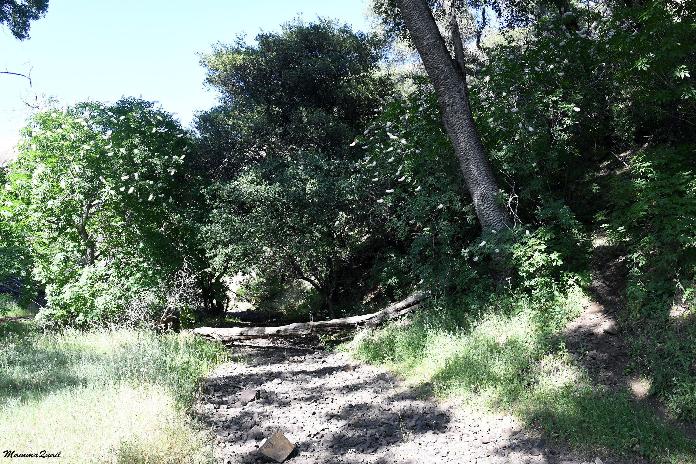
The lower part of trail downhill was more manageable and less scary. It was also more protected area, and much richer in vegetation. The west-facing side of the canyon cut by that little creek (which does run strong after powerful systems) was full of trees. Most were buckeye and oak, but I also spotted a few madrones. 


Trail
 
Below one of the trees I spotted a single straggling clarkia blooming. All of its friends were already done with that phase. 
Woodland Clarkia, Clarkia unguiculata 
 
The buckeye however, were at their peak bloom. I love the chandelier look of these trees when in full bloom, all covered with the flame-looking inflorescences.

California Buckeye, Aesculus californica 
 
The trail drops to the canyon bottom a bit downstream of he base of the waterfall. The 'stream' was nonexistent, though.

 
We walked to the base of the waterfall. A thin film of moisture glistened on the waterfall chute and the pond at the bottom was the size of a small puddle. We sat down on a fallen log in the shade of a luxurious buckeye tree, ate our snacks, and enjoyed the quiet solitude.   

Hollow Falls
  
The North Table Mountain is made of volcanic rock that eroded with time and weathering. Looking up at the lip of the canyon at the place we descended from. There were pillars of basalt there, not completely formed into hexagons, but they did remind me of the Devil's Postpile National Monument. I was mesmerized by the moon floating above the rock pillars formation.

 
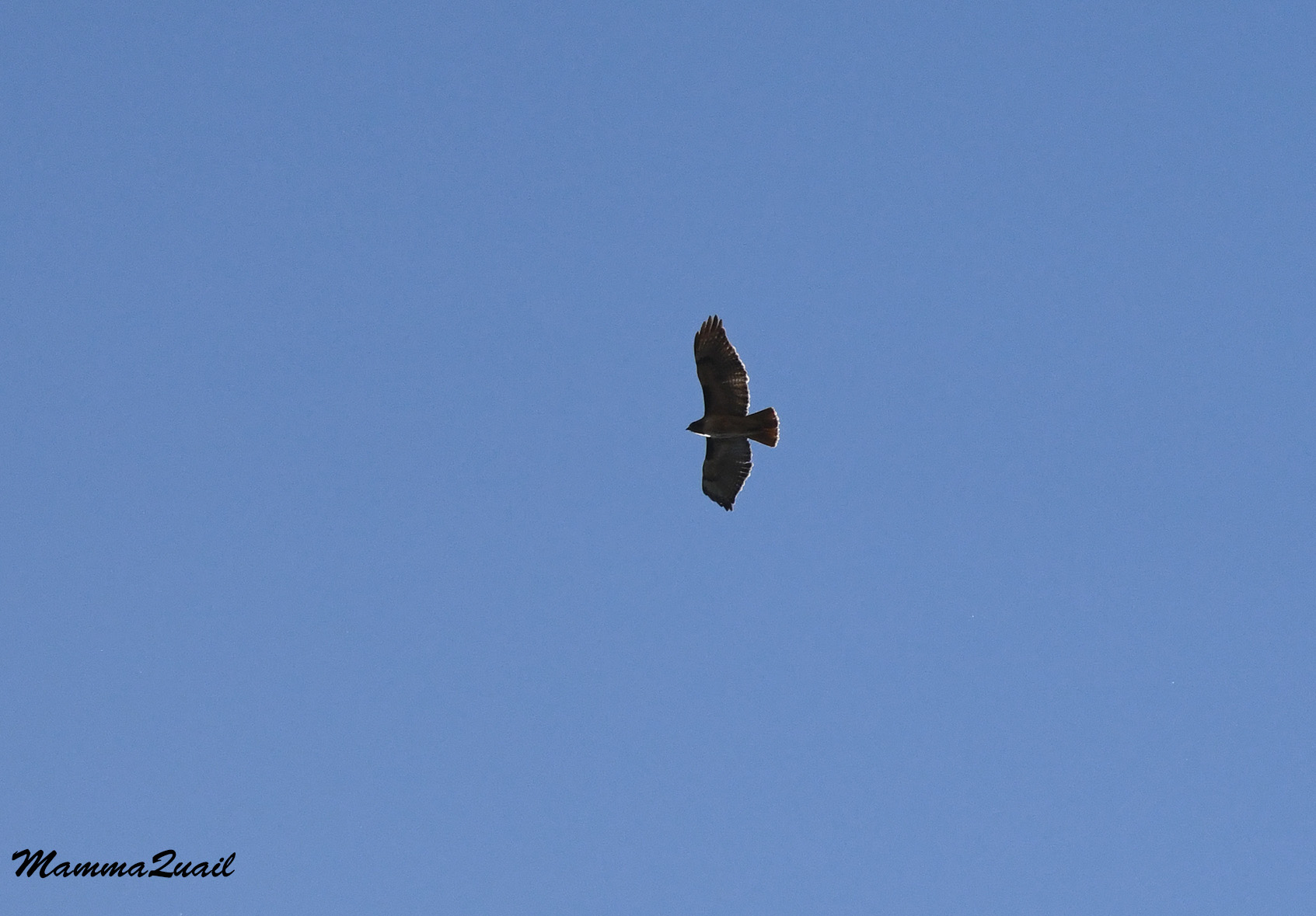
Above us floated also a red-tailed hawk. Pappa Quail didn't bother to point his camera at it, but I did. I wanted to remember it was there. 

Red-tailed Hawk
 
Eventually it was time to get up and go back. At the bottom of the canyon I noticed a weird looking buckeye tree. When I got closer I realized that the tree was covered entirely by wild California grape, and had only its blossoms poking through the vine cover.
Grape-covered buckeye tree
 
Pappa Quail started ascending but I had to get closer to check that grape-buckeye chimera.  I wonder how can the tree get enough sunshine underneath the grape.     
 
 
Near the tree bloomed some thistle plants of an invasive species. A swallowtail butterfly was enjoying the thistle flowers. It was heavy and flew slowly despite the heat. It didn't seem to mind my presence so close.

Pipevine Swallowtail
 
Back on the canyon lip I found a safe spot and gazed down to the base of the waterfall. I was impressed by how much thicker the vegetation was just below the table mountain top. Such a big difference that the angle makes.
Hollow Falls
 
We were returning on the same trail but going back I did notice some things that I had missed earlier, like this really tiny lupine, the only one I saw there that day.  

Lupine, Lupinus sp. 
 
We had a quiet walk back. There were even fewer people around now. A couple that found a romantic spot under a tree was there still. We passed them quietly and I thought to myself that this was a lovely spot to pass a few romantic hours.


We approached again the stand of trees that thrived on the little creek. Pappa Quail spotted another bird there and hurried over there to find it with his camera while I paced slowly along the creek.  

 
Pappa Quail found the bird. It was a flycatcher, possibly the same one he saw there earlier.   
Ash-throated Flycatcher
 
I found something even more interesting (in my opinion, of course): a little garter snake that was swimming in the creek. I called Pappa Quail over and he came in time to see the snake too.  

Mountain Garter Snake, Thamnophis elegans
 
All the other wildlife I saw near or on the water were bugs. Like this water walker that I frequently see in creek waterholes.  

 
There were quite a few damselflies by the water as well. So little water, and so much life it supports! I wonder what do all these animals do when the water dries up in summer. It occurred to me that I don't know that the spring by the trailhead actually dries up, I simply assumed it does. I need to check it out.

Damselfly
 
We competed the rest of the hike and knew that we won't be back there tomorrow. We saw what there was to see, which was not much but also quite a lot, considering how late in season we were there. We decided to head up to the mountains on the morrow, for a change in scenery and to escape the heat.
 
On our way back to Oroville we stopped so I could take a photo of the mariposa lilies that I spotted earlier. On the other side of the road behind a fence was a pond with a few ducks. While I was giving attention to the mariposa lilies Pappa Quail looked at the ducks. The little pond looked lie a lot of water compared to the thin creek we just hiked alone.
 
Proximity to water is everything in the plant world. The grass near the road was too far from the pond, and very dry already. I was happy to see some brodiae flowers blooming in the dry grass and a snapped a quick photo before getting back into the car.
Brodiae sp.

The North Table Mountain Preserve is one of those places that have an incredibly short season in which the pauper becomes a prince. In recent years it had gained much popularity among flower seekers, and the crowds can be dangerous to the delicate beauty of this place. I was there before during a super bloom year so I don't feel sad about coming again at the end of the season, as the prince slowly returns back to his pauper sleep. It has its serene beauty still, but without the crowds.  


Saturday, May 27, 2023

Carrizo All Around, 2023 Superbloom Spring

Tremblor Range, April 8, 2023
 
 
Date: March 4-5, and April 8, 2023
Place: Carrizo Plain National Monument, Paso Robles, California


I was fortunate to visit Carrizo Plain National Monument twice this spring, just over one month apart. That one month made all the difference in the world.  On my last blog post I wrote about the Overlook Hill and the Soda Lake Trail. This post has no hike but a narrative with photos of the drive around I did after that hike, which my accounts of these visits would not be complete without.

On my March trip to Carrizo Plain I was alone and I intended to camp at the Shelby Campground in the park. There was plenty of daylight still after my Soda Lake hike so I decided to go up to Caliente Ridge Trail and check out the conditions there. I wanted to be sure that the dirt road leading up to the trailhead was passable. In addition, there was still snow up the ridge and I thought it would be nice to see it up close. 
Caliente Ridge, March 4

Something small and brown was moving across the green field. I looked through the lens and saw it was a fox. Of all the photos I took of that fox, the best image was when it paused to do its business. I'm glad that foxes don't read my blog. 
Fox, March 4

The contrast of the looks of those fields with what I've seen only a month later was stunning. There was no fox, but there were lots and lots of people. And flowers as far as the eyes could see. 
April 8

Early on March there was snow still at the heights of Caliente Ridge. The road was not gated but it was very difficult to drive. The dirt road, which was not the best even on my previous visit there, was now muddy and in many places rutted deeply. It was an exhausting challenge to ascend all the way up to where the trailhead was. I tried going a bit further, but on the ridge there were also snow patches on the  road and the mud was very deep and slippery, and I decided it wasn't worth the effort and turned around. 
Snow on Caliente Ridge. March 4

I didn't drive back down however. Along the dirt road there were a few pull out areas which improvised disperse campsites. On my way uphill I saw some campers in the lower sites and I decided that I too, should stay and camp up the ridge. That'll save me the grueling drive uphill again tomorrow, or so I thought. I settled in one of the higher disperse campsites and used the fading daylight to  pitch my tent and to gather some firewood. I cooked dinner and ate solemnly while watching the glorious sunset. 
Sunset. March 4

Sometime during the night the wind started blowing, and by dawn it was whipping so hard that the tent kept flattening and bouncing back, hitting me each time. I worried that my tent would eventually break so I dressed up quickly (a real challenge inside a tent that keeps dropping every few seconds). I gathered my things and got out into the morning chill and a fog so dense that I couldn't see more than a few yards ahead. I quickly took the tent down, shoving everything into the trunk without even folding  the tent or rolling up my mattress. The wind was so brutal that I had to struggle to keep upright myself. Without any delay I started my drive downhill. There was no Caliente Ridge Hike for me that day. 
An hour later I stopped at the KCL campground to roll my sleeping pad and fold my tent. A soft hoot from the nearby eucalyptus grabbed my attention, and I was very excited to find an owl there, staring down right at me! 
Great Horned Owl, March 5

I didn't get to hike the Caliente Road Ridge on my April visit either, but that was because my chika was still in a bad mood after the Soda Lake hike and didn't want to hike. We did however, drive up to the Ridge Trail and continued a bit north to the dirt road. The view northeast from the ridge was wonderful. The entire soda lake and the blooming Tremblor Range behind it took my breath away. 
View Northeast from Caliente Ridge, April 8

Although no longer muddy, the road up Caliente Ridge was still pretty damaged, forcing me to drive very slowly and carefully. There were also many other cars going up and down that road, and more than once we had to find a creative way to pass next to each other. Occasionally we stopped so I could take a closer look a wildflowers by the road side. 
San Joaquin Blazing Star, Mentzelia pectinata, April 8

Right on the ridge I stopped to look down the other side. To my amazement, I could still see some snow on the top of the Sierra Madre Mountains on the west. The foothills below were burning yellow with wildflowers. It was simply spectacular. 
View West from Caliente Ridge, April 8

Perhaps some of that yellow were the flowers of the Ericameria bush. I suspect though, that the yellow carpets were most likely the hillside daisies. 
Interior Goldenbush, Ericameria lineariflora, April 8

My chika said she was hungry. and I found a place with enough pullout space to get park the car of and we sat down for a light picnic lunch. All around us bloomed desert candle plants. I've only seen these lovely flowers in Carrizo Plain National Monument. 
Desert Candle, Streptanthus inflatus, April 8

The road continued down to the valley on the west. Another time I might have tried going down there, but our time on this visit was limited and the chika wasn't too open for explorations so after our lunch we turned around, back on the Caliente Ridge Rd. I was driving very slowly, taking in the tapestry of flowers covering the west-facing slopes. 
Caliente Ridge, west-facing slope, April 8

Going down the road on the east side back ti Carrizo Plain was a very slow business, not only because of the road condition and the incessant uphill traffic, but also because of the multiple flowers blooming right there by the road. Whenever I could I would pull over to give them due appreciation.
California Poppy, Eschscholzia californica, April 8

Most of the wildflowers I already knew but occasionally I'd see something different. I'm not sure which species is the Phacelia in the photo below.
Phacelia sp. April 8

Even very common wildflowers that I seen every spring in many places in California seemed more festive here in this desolate National Monument.
Sky Lupine, Lupinus nanus, April 8

I stopped for a bird hopping by the road. It was a horned lark, one of many I've seen in this park before, even earlier that day. This one, however, seemed unbothered by us, perhaps because we were inside the car. 
Horned Lark, April 8

Back on March 4th there were very few people around. On the other hand, there were plenty of wildlife. Besides the fox and the owl, I also saw a herd of elk on my drive south on Soda Lake Road.
Elk, March 5

They weren't very close to the road but on that trip I had also the strong lens and I could zoom in better from a distance.
Elk, March 5

When alone and without time pressure, I like to explore side roads. I did so also on my March trip, trying to avoid any seriously muddy roads. On one of those instances I came close to an early blooming field of Great Valley Phacelia.
A Patch of Great Valley Phacelia,  March 5

The individual plants are not very large but when they all bloom together they create an effect in such a magnitude that it can be seen from space.

Great Valley Phacelia, Pgacelia ciliata, March 5

A month later the purple carpets covered great areas of the plain. Not having an aircraft I could only appreciate it from a sharp angle.
Great Valley Phacelia, April 8

A bit further south I came close to a patch of hillside daisies at the beginning of their bloom. These flowers too make huge patches of color when they peak.
Common Hillside Daisy, March 5

They are great companions of the Great Valley Phacelia. The combination of purple and yellow is one you'll never catch me wearing but I love seeing it in flowers.
Common Hillside Daisy, Monolopia lanceolata, March 5

Both the Great Valley Phacelia and the Common Hillside Daisy were at peak bloom on my April visit at Carrizo Plain. There were huge carpets of them as far as the eye could see. It was marvelous.
Great Valley Phacelia and Common Hillside Daisy, April 8


On the south east side if Carrizo Plain, just below the Tremblor Range, there's a ridge of low hills called Elkhorn Hills. Between Elkhorn Hills and Tremblor Range there's another dirt road that stretches north to south, called Elkhorn Grade Road. Numerous traverse dirt roads, some marked and some not, connect Elkhorn Grade Road with Soda Lake Road. On my March trip, many of these traverse roads were too muddy to go on, so I crossed over on one of the roads near the south end of the National Monument. On my April visit I chose to go on that road again, despite the others being dry. I remembered  there was a nice viewpoint on the way, and sure enough - I had  great view of the bloom on the usually very arid Elkhorn Hills. 
Elkhorn Hills April 8

The traverse dirt road that I crossed on goes up the Elkhorn Hills and down the other side. This road, like many others in the park, is not very good for regular cars. My chika dropped har eyes to the floor as I charged up the steep grade with my battered SUV at the top of the hills. At the top was another nice vista point, looking over Tremblor Range and the plain in between. I had to stop there and take that sweeping view all in. 
Tremblor Range virewd from Elkhorn Hills. April 8

I was glad that no other car was making its way west as we dropped down the steep road to the east. All the way down I saw a few milkvetch shrubs and I had to stop again - I've seen them before, but never at peak bloom. They were simply gorgeous. 
Diablo Lockweed, Astragalus oxyphysus, April 8

I turned left on Elkhorn Grade Road and started driving north along the Tremblor Range. Back in March there was very little bloom but the Tremblor Range all green, a very unusual look for it. A thick cloud was hanging over the mountains, allowing only an occasional ray of sunlight through. 
Tremblor Range, March 5

The looks of the that normally very arid mountain range was completely turned when I saw it again in April. Finally I could leave behind all the bad feelings I had from seeing the people trampling the flower fields earlier that day by Soda Lake. I let go of everything, looked with admiration at the mountain bloom and breathed in their ethereal beauty. 
Tramblor Range April 8

The intensity and composition of the bloom changed as we moved north along the road. Occasionally I'd stop or go toward the mountains on one side road or another to take a closer view.  
Tremblor Range, April 8

Back in March when I drove along Elkhorn Grade Road I had to go through mud puddles and over many holes. One of the holes was too big for even my car to go across, and there was no way around it. I pondered what to do for a few moments. I didn't want to go back but there was no going forward as the road was. Eventually I remembered my snow shovel in the trunk. I took it out and spent about 15 minutes filling the hole with dirt and gravel that I dug out of the sides of the road. When it was filled enough for my car to go across I was all sweaty and panting. I took a few moments to recover, and to look at the few early wildflowers that bloomed near the road - the very first goldfields. 
Common Goldfields, Lasthenia gracilis, March 5

When I came upon that same place on my April visit I saw that others have done work to full that hole, and there was no issue driving across it that time. I did stop however, because there was a large patch of cream cups blooming right by the road. 
Cream Cups, Playstemon californicus, April 8

Tucked inside a deep gulch was an old ranch with a rotted corral and a few half collapsed buildings. I drove there because the mountain right above it had a lovely bloom of Phacelia and poppies. I thought I heard people walking there but I couldn't see them. There was a barb wire fence between the road and the blooming mountain. I admired the bloom but then turned around and went back to the car where my chika was waiting patiently, and drove back to Elkhorn Grade Road. 
April 8
 
Elkhorn Grade Road goes roughly along the the line of the San Andreas Fault. Near the north end of Carrizo Plain National Monument there is a lovely geological site where the fault's action is vividly seen and that's the bend of Wallace Creek. It's a location I visited a few times before and even wrote about it here. On my March trip I stropped there and hiked that trail again, including a walk all the way up to the base of the mountain. I compared the photo of the creek's bend from this trip to the one I took in January of 2023 from the same spot (in the link above) and I'm amazed at the similarities and the differences.
Wallace Creek, March 5
 
Right by the creek bend I found some early blooming wallflowers.
Wallflower, Erysimum capitatum, March 5

I thought to hike there also on my April visit but by the time my chika and I arrived there we found the parking area full and overflowing. A busy line of people stretched from the parking area to Wallace Creek bend. A at one my enthusiasm was deflated. The chika too preferred to move on. I did take a chance while we were there to take a close up look at the fiddleneck plant at the edge of the huge and vibrant field of these little orange flowers.
Desert Fiddleneck, Amsinckia tessellata, April 8

The short distance between Wallace Creek and the 7 Miles Rd outside of the north boundary of the park has the Tremblor Range right in the front view. It is very tempting to stop at every curve and look.
Tremblor Mountain Range, March 5

Needless to say, we also stopped there in our April trip.
April 8

Already outside the park's area, on 7 Miles Road, I had to stop again for a final appreciation of the developing superbloom. All that wet winter it was anticipated, and at the timer of my March trip I was not sure I'd be able to see it at its peak. As it turned out, I did go, but I also had to deal with the anxiety of the human crowds. Carrizo Plain is a magical place. I love it when it's dry and the geology is bare, but when it's green and blooming, it is a place to write fairy tales about - inspiring.
March 5


After my March visit I tried hiking around Avenal but the building storm erupted and I went on to the Pinnacles National Park instead. At the and of the April visit my chika and I continued on our way to Mammoth Lakes. The day after we got to see the magnificent desert super bloom at Red rock Canyon State Park, an awe-striking event of its own right.