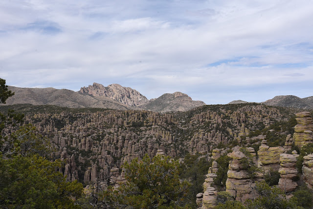
The Chiricahua National Monument is engulfed by area of the Coronado National Forest. We saw a pullout with a sign and stopped to look. There were a few wildflowers nearby, of species the I didn't see later inside the park.
 |
| Five-eyes, Chamaesaracha sp. |
There wasn't any evidence of any major bloom but I was happy to see even the few flowers that were blooming there.
 |
| Desert Marigold, Baileya sp. |
It was just late in the morning when we finally arrived at the park. We stopped at the visitor center to get recommendations for hikes. Having planned a longer hike today, we also needed to get more water bottles.Following the ranger's suggestion we drove up the road to the second highest trailhead right above the Echo Park site.
 |
| Our hike as captured by my GPS |
The the Echo Park Parking we were faced with two options: hiking a 7-miles in and out trail to the Heart of Rocks loop, which was the
best featured rock formations area, or an 8.5 miles large loop that
would also go through the Heart of Rocks, but would return up the Echo
Canyon trail. Pappa Quail was skeptic about our ability to hike the second option in the time we had. We were
late in the park and he didn't think we'd have enough daylight for the
longer loop. We decided to decide on that later and started down the Ed
Riggs Trail.
 |
| Ed Riggs Trail |
The view up at the high plateau didn't indicate much of what we were about to see. It was beautiful but only one seal-shaped rock represented the type of formations that hid below the canyon lip.
Even before we started descending into the canyon I was already seeing wildflowers. I didn't expect many flowers. After all, there wasn't much bloom on the eastern side of the mountains where there was water. Yet here, despite the complete dryness, there were many more flowers blooming.
 |
| Gilia sp. |
It wasn't anything close to a super bloom, not even patches. Just blooming shrub here and there. It was enough though to please me.
 |
| Hassayampa Milkvetch, Astragalus allochrous |
The trail steepened and started some switchbacks. When we turned the corner the hoodoos came into view. There were lots of them - like an army turned to rock on the slopes.
Hoodoos are those pillars of rock, separated from the mountain's bedrock by erosion, The most famous hoodoos are those in Bryce Canyon National Park where they are formed from red rocks and their beauty attracts visitors from all around the world (including me, I just haven't written about it yet).
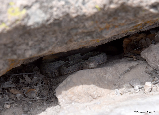 |
| Rock Rattle Snake |
We didn't linger there long. After taking a few quick shots of the snake (which turned out to be a lifer species for us), and of a pretty blooming thistle with a butterfly visitor, we went on down the trail.
Further down, at the crossing of a dry side creek we found a nice shaded corner with ricks that were comfortable to sit on and no snakes rattling, we stopped for a lunch break. Almost as soon as we sat down a jay bird flew down and started hopping around us, getting very close at times. So close, that I got better photos of the bold bird than my family birders whose camera lenses were too powerful for a short distance photo. The bird was clearly used to human feedings. We didn't feed it, of course. This isn't good for wildlife to depend on human food.
 |
| Mexican Jay |
The trail continued on the east side of the creek, some distance above it. It was a nice day so far with partially clouded sky and a nice breeze. So far the walking was easy and we made good progress. I was optimistic about our ability to do the entire large loop, but I kept my thoughts to myself.
 |
| Ed Riggs Trail |
I found flowers that I remembered from our hikes on the eastern side of the Chiricahua Mountains, at Cave Creek Canyon. The mock verbena I recognized right away, it has such a distinct look.
 |
| Mock Verbena, Glandularia sp. |
For a good while we were walking inside a deep canyon on a trail surrounded by trees, and didn't see any hoodoos. Then we came across a sign saying 'balanced rock' with an arrow pointing up to the top of the other side of the canyon. We actually had to walk a few steps forward to see what the arrow was pointing at.
 |
| Balanced Rock |
There were more flowers along the trail. Some looked familiar, being close relatives of plants I know from California, like this pretty groundsel in the photo below, which probably was the most common wildflower along that trail.
 |
| Wooton's Ragwort, Senecio wootonii |
And there were other plants there too, of species that were completely new to me. Unlike my family birders, I wasn't counting 'lifers', though. This entire trip was a discovery journey for me.
 |
| Oregon Boxwood, Paxistima myrsinites |
The wildlife were a different story. Nearly every animal we saw there was new to us, including the lizards. When we reached the bottom of the dry creek we started seeing many of them. They liked that area and we saw numerous lizards sunning themselves on the rocks.
 |
| Yarrow's Spiny Lizard |
We crossed the dray creek and continued along its west side, still heading south in the downstream direction.
The creek bottom was devoid of water at the time of our visit, but it was full of groundsel flowers. There were even a few butterflies fluttering among them.
The creek curved west and continued downhill toward the visitor center and eventually to low desert plateau. west of the mountain range. Our trail curved west too but was now ascending uphill north of the creek.
We were out of the tree zone. At list out of the live trees zone. All the vegetation around us was now comprised of bushes, most of them manzanita. A few years ago this would have been a forested area. All that was left in evidence of the forest were charred logs, only few of them still standing. And there was a small stand of trees that had survived the fire, by their tops.
Higher on the hills I no longer saw the herbaceous wildflowers. The manzanita bushes were in full bloom however, and that was more than enough compensation.
 |
| Pointleaf Manzanita, Arctostaphylos pungens |
We reached a trail junction with an in-and out spur leading to a place called 'Inspiration Point'. Given more time we might have gone there to check it out, but it was it was clear without any discussion that this wasn't an option if we wished to return through Echo Canyon. We did stop there for a short break, and had a nice chat with a pair of hikers that were coming down after having hiked the Heart of the Rocks loop.
From there we continued on a nearly level trail on top a high plateau with many manzanita bushes and a very nice view all around. On the time it took us to get the high plateau the wind had picked up and was beating on our faces. The clouds now covered nearly the entire sky with the sun only poking through small cloud breaks here and there.
From our location on the high plateau we could see westward all the way to the flat desert below, as well as the peaks of the next range over. We also saw a large field of hoodoos that was not too far to our northwest, and stretched all the way to the edge of the mountain.
We were about to get much closer to the hoodoos. There's a short trail spur that connects the main trail of the large loop with the Heart of Rocks loop of the most notable hoodoos in the park. As usual, I made the turn last and purposefully lingered behind so I could take photos of the trail when apparently 'empty'. The photo below is posted with Pappa Quail still in the frame to have a size reference of the rock formations.
We took another short break between the rock formations that adorned the trail connector. There was another one there that bore the imaginative name of 'Balanced Rock'. Thankfully, this hoodoo was far enough from the trail and not in a place where people might test the rock's balance.
 |
| Balanced Rock |
These rock formations, other than being beautiful they also provide shelter to the littler life forms. There, between the hoodoos, I was seeing once again some herbaceous wildflowers.
The trail was no longer level. We descended between the hoodoos and, while loosing the wide view, we got really close to the fascinating rocks.
After a short descent we reached the beginning of the Heart of Rock loop, which was at the bottom of a dry creek. It was easy to see where one arm of the loop was continuing but a bit more difficult to determine where the other arm was going to because it was going at a steep slope curved between some big boulders with a couple of 'pirate' alternatives nearby. Not wanting to make a mistake in choosing the right trail we started up the most obvious loop arm, going counter-clockwise on the Heart of Rock loop.
 |
| 'Hive'-like Rock |
The Heart of Rock trail is anything but level. It goes up and down, around and between the rock formations, each of which gorgeous and very unique. It didn't take me long to find that the trees growing among these rock formations are also very unique in their appearance.
 |
| Twisted |
The cracks and gaps between the formations were also fun to explore. Whenever it was possible I actually took a step into a gap to see what I could see through it.
I must say that our own imaginations led us to suggesting different names ... d I'm not sure that they would have been accepted as official park-labeled names though.
 |
| Old Maid |
I admired the trees that thrived on the precious little soil that was trapped between the rocks. The species balance shifted here in favor of the oaks and a couple other broadleaf species. I saw only very few pines on the Heart of Rock loop.
I wonder if the person naming this rock has ever seen a camel in real life. I have, and the resemblance is weak. To me it looked like an anvil, possibly dropped there by Wile E. Coyote.
 |
| Camel's Head |
The biggest challenge for me in writing about sights-packed hikes like tis one is choosing photos from the gazillion that I take on these hikes. Most often those would be wildflowers photos, but on this hike these were definitely the hoodoos. Each of these rock formations had its own unique looks and groups of hoodoos together had their own fantastic shape and impression, and from more than one angle.
 |
| Unnamed Pillars. I would call these, "Samson's Last Stand" |
Cutting photos from these post was truly painful, but I wanted to keep this post at a reasonable length. Besides, these photos convey only a tiny fraction of the true impression they give in real life. One just must go there in person to get the full experience of walking between these rock giants.
 |
| I would name these 'Claws from Nether' |
Every now and then we would have a wide enough opening between the rocks to see the vast flat desert below. Later we would drive through this flat desert in total darkness, seeing none of it up close.
I'm glad that Marvell Studios had a more vivid idea of how the mighty Mjolnir looked like, because the rock in the photo below doesn't inspire this particular name in my mind.
 |
| Thor's Hammer |
Under one of these immense rocks I found a blooming hedgehog cactus. It was the second one I saw on the hike but this one looked the prettiest. I love the contrast between the harsh, spiny cactus body and the very delicate and fragile-looking flowers.
 | |
|
At the north tip of the Heart of Rock loop we had a great view of the hoodoo army below us. It was the north side of Echo Canyon. It's amazing to think that only this mountain was thus carved and all the surrounding mountains remained round and smooth.
Hoodoos don't stand forever. The erosion process continues and eventually topples them over. I saw one of them that reminded me of a too high pancake stack.
 |
| A Collapsed 'Pancake Stack' Hoodoo |
I couldn't get enough of the view of hoodoos all over us. This photo below nearly became the header for this post.
Finally, a rock formation with a fitting name! I can imagine this duck going swimming and goes straight to the bottom.
 |
| Duck on Rock |
At the highest part of the loop there were no large formations but there were two saucer shaped clouds floating low and standing out of the higher clouds background. It looked unusual enough to me and I wanted to remember it.
The trail begun descending again, and for a minute or two it seemed liked we saw all the special features on the Heart of Rock loop.
But we were wrong. There were a few more neat formations on our way down to complete the loop. The Kissing Rocks, for example. Pappa Quail thought there's a word missing in the middle of the formation's name ...
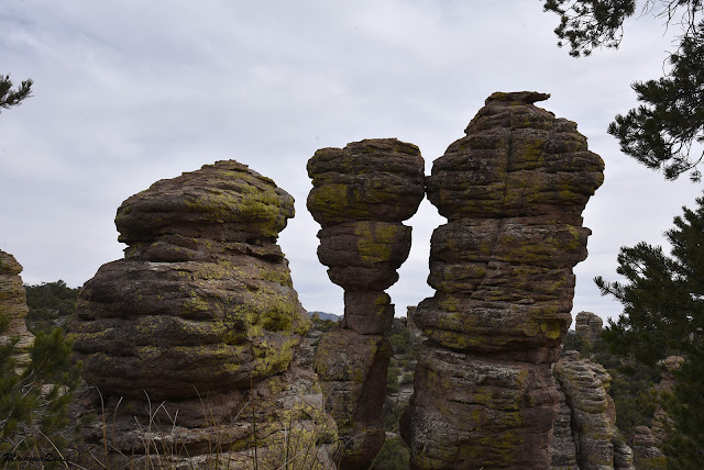 |
| Kissing Rocks |
We descended again between large pillars of rock. Soon we closed the loop and without any break we returned up the short connector trail to the main trail interaction. There we did sit for a short break. We also needed at last to solve our dilemma: should we continue down Sarah Deming Trail to return by Echo Canyon, or should we backtrack our steps, returning on Ed Riggs trail whence we came?
It was around 4 pm when we were back at the main trail intersection. To complete the wide loop via Echo Canyon meant about 4 miles more, the last part of it being uphill. Pappa Quail was seriously doubting hat we could complete that before sunset and he was adamant about not getting stuck there in the darkness, a sentiment which I absolutely agree with. I did think however, that walking these 4 miles in the three hours of daylight we had was totally within our ability, also considering that sunset doesn't mean immediate darkness, especially on the west side of the mountain.
I wanted to go on but I left the final decision to Pappa Quail, and resigned to the option of turning back. To my surprise Pappa Quail decided to go on too. As soon as he made up his mind we got up and started down the Sarah Deming Trail.
It was a long descent to the bottom of the canyon. The view was great but I didn't take many photos on that trail segment. Pappa Quail and the chikas were charging down the trail at a quick pace and I didn't want to hold us back so I resisted the urge to pause too frequently for snap shots.
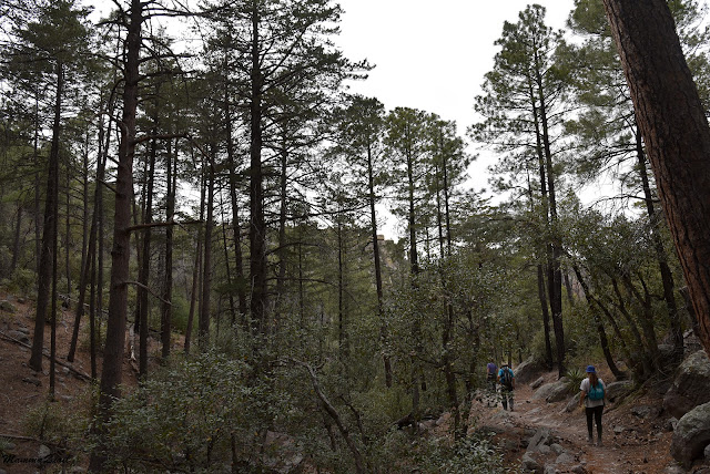
down in the canyon we were back inside the forest. The trees on this side of the creek were really tall. The creek here too was completely dry. We followed it along the trail in the downstream direction.
At some point the trail dipped down to where it crossed the dry creek. Just before crossing Pappa Quail noticed a little gray bird on a low branch near the crossing. He and the elder chika spent the next few minutes circling that spot and taking the bird's photos from every possible direction. To me it looked like any other little gray bird but this one turned out to be a lifer for them, the only lifer bird that they saw on in Chiricahua National Monument. That's a +1 for choosing the longer route.
 |
| Dusky Flycatcher |
There were very few people on this side of the park. In fact, after coming down the switchbacks we only saw two or three other hikers. The peace was very much to my liking. It was just us and the silent hoodoos.
Other than the ceanothus there were a couple other bushes blooming in white by the trail side. It was difficult to take a clear photo of these because by then the wind has intensified considerably. By the time I was done photographing the dancing bush I had to almost run in order to catch up with the rest of my family.
 |
| Lewis' Mock Orange, Philadelphus lewisii |
We basically galloped down the last downhill trail segment, which was made easier by a nice flight of stairs that were at a reasonable height, for a change. We reached the main trail junction of the park and there we had another little dilemma, because I suggested that Pappa Quail, who was still concerned about running out of daylight, would take the chikas left and head down the Lower Rhyolite Canyon trail all the way to the visitor center, while I go up and bring the car down to pick them up. The chikas were all for that plan but after a short debate it was shot down, and after a brief water break we all headed up the Upper Rhyolite Canyon Trail, which would connect us with the Echo Canyon Trail.
Now we truly were racing the clock. Thankfully the trail, which was a constant incline, was not too steep and we could keep a good pace. Still, there was a good distance to traverse yet.
Half a mile into the incline we connected with the Echo Canyon Trail. I didn't take very many photos on most of the ascent because I wanted to keep up with the rest of my family. After being pointed at as the slowest hiker in the family I was motivated to not be the one who'd be blamed if darkness caught us still on the trail.
Still, I couldn't resist a camera click here and there, especially If I didn't have to stop to take them.
A steep section of switchbacks brought us high above the canyon to a great view to the west and the early evening's pink clouds.
Almost all the way up with only a little uphill ascent left we finally reached the Echo Park rock formation area, indicating that we were nearing the parking lot at the end of the loop.
But it was at Echo Park that we all slowed down. Not that we got tired of the ascent. On the contrary, we all felt renewed energy seeing the gorgeous hoodoos and formations as we walked through Eco Park.
This time it wasn't only me who stopped to explore and appreciate the pretty formations. Even Pappa Quail and the chikas went on and around rocks and peeked through crevices and up rock chutes.
It was fun going through narrow sections, and calling out loud to hear the echo, as this part of the trail was indeed named well.
The trail switchbacked tightly and steeply through part of Eco Park, and looking down or up the rock chutes to see who is on the next switchback over was both fun and scary at the same time.
Eventually the trail leveled again. Almost leveled, but the remaining incline was barely noticeable. But we were not out of the stone woods yet - there were still narrows and hoodoos to walk through. We did pick up our pace there however, because the sun was already setting and the clouds made it darker than if would otherwise been. .
Outside Echo Park it was brighter but we knew is wasn't for long. We walked quickly but I was trying to capture everything, or at least seeing each hoodoo on our way.
It is my opinion that the hoodoos of Chiricahua are no less beautiful than those of Bryce
Canyon. They are not red and they are tucked inside canyon and not
standing in a wide open amphitheater as in Bryce Canyon National Park,
but they are just as gorgeous and awe-inspiring. I with I could spend more time there.
A bit of an uphill trail brought us to a point where we could see the parking lot. At that sight the chikas just about doubled their gait and disappeared from view, leaving Pappa Quail and me in the dust. Pappa Quail remained behind with me this time. I think he had relaxed after seeing the car, and how close we actually were to the end of the hike.
Coming in facing north I noticed the Sugarloaf Mountain peak ahead. The trail ascending it was one we considered when we were looking at possible hikes earlier that day. Going up that peak would have to wait to another visit in Chiricahua National Monument, whenever that will be.
 |
| Sugarloaf Mountain |
Pappa Quail and me were both walking slowly now. Our previous fast pace has taken its toll and Pappa Quail complained of knee pains. We enjoyed a quiet talk and the beautiful surroundings. Pappa Quail recounted all the lifer birds that he and the elder chika had seen, and I found this little bonsai like tree near the trail.
We made it to the parking lot just as the sun finally made it out of the clouds, only to sink behind the slope of Sugarloaf Mountain. We found the chikas already sitting in the car, snacking on whatever they found in the back. We promised them dinner in Wilcox, the first town on our way to Tucson, and started our long drive down and out of the Chiricahua Mountains in the dark.
This hike concluded our three days visit to the Chiricahua Mountains. I do believe we could have spent the entire week there and not see everything this place had to offer. Perhaps we will go back there again. Now we were ready for the second part of our spring break, which would center around Tucson.
