
 |
| Windswept Interior Live oak, Quercus wislizeni |
Date: June 14, 2023
Place: Pacheco State Park, Hollister, California
Coordinates: 37.063158, -121.214922
Length: 7.5 miles
Level: strenuous
Earlier this month I went to Pacheco State Park to scout a trail for a possible collaboration event. I've hiked in that park before - it is has a lovely wildflowers display in spring. I was dubious about hiking it in summer though. I anticipated it would be very dry and hot. I was convinced to go and check it out anyway, and although I was correct about it being both dry and hot, I didn't regret the hike one bit. Being on my own, I hiked a longer loop than I would have taken families on. The views were stunning. and there were some wildflowers still blooming in small numbers. It was hot all right, but not scorching. Although my conclusion was as I suspected - that this park would not be a good destination for a group of hiking families in the height of summer, it is still a very nice destination for more seasoned hikers.
 |
| My hike as captured by my GPS |
I planned to reach the park early but I was delayed, so it was already mid-morning when I stood at the trailhead and looked at the golden hills. Last time I was there those hills were green. The seasonal transformation here is striking.
 |
| Spikes Peak Trailhead |
At first sight it looked like the bloom was all gone for this year. A little into the trail however, I saw some blooming plants. Not in large number or in wide species diversity , but some nice late bloom nonetheless.
 |
| Hill Morning Glory, Galystegia subacaulis |
The summer bloom in the California interior is dominated by numerous species of tarplants. These (often yellow) composites look green and lush even in the driest conditions.
 |
| Rosin Weed, Calycadenia truncata |
The true botanical royalty of this hike was the interior live oak. Individuals of this species assume the strangest shapes, each more incredible than the other. I photographed them all and had a really hard time choosing what to post. I chose one, very windswept-looking, to head this blog post. In the photo below a group of interior live oak trees flank a California buckeye in full bloom. It's been a good year for the buckeye.
 |
| Interior Live Oak, Quercus wisnizeni, and California Buckeye, Aesculus californica |
I took the turn to Pig Pond Trail, crossing the county line From Santa Clara to Merced County. Overhead a hawk flew by, shouting loudly, I don't know at what, or about what.
 |
| Red-tailed Hawk |
This park was once the area of Pacheco Ranch. Although a state park today, the area is still used for cattle grazing. Here and there were cattle fences and cattle feces, but I haven't seen the cattle yet.

Park of the Rancho legacy are the man-made ponds built to collect the rain runoff water to supply the ranch's needs during the dry season. One such pond is Pig Pond. The trail only goes by it's short end but I walked all the way to the other side where the earthen dam was. I found a sole and crumbling picnic table there, so I sat down for a quick break and munch, and gazed at the calm water.
 |
| Pig Pond |
There were no waterfowl in the pond. Not a single mallard or coot. and why would they, when a short flight away was thee large San Luis Reservoir? On the far shore however, I did spot a couple of killdeer. They were so well camouflaged that I only spotted them because they kept calling loudly.
 |
| Killdeer |
There were also little white flowers blooming in the pond - an aquatic buttercup. I couldn't get a good shot of the tiny little flowers without risking sinking in the muddy waters.
 |
| White Water Buttercup, Ranunculus aquatilis |
On my way back to the trail I met a little fence lizard that didn't mind posing a bit for me before ducking into the nearest crevice.
 |
| Western Fence Lizard |
I started up the trail on the other side of the pond. The hillside was all rutted by ground squirrel holes - a very good reason to stay on trail . One of the squirrels was bold enough to forage on the trail while eying me carefully as I walked by.
 |
| California Ground Squirrel |
Pretty much the entire park is an oak savanna, meaning open grassland
hills dotted with oak trees, individual or stands of them. Knolls are a
very common sight there. Today's grasses are nearly all invasive,
brought intentionally or as hitch-hikers with the Spanish missionaries
and later European-descent or educated settlers. These grasses are
mostly annual and go dry each summer, painting the hills gold, then
brown. Because they're highly flammable, sometimes the hills turn black.When I was there however, it was golden time, and very beautiful.
 |
| Pig Pond in the Oak Savanna |
I also saw some other late spring - early summer bloomers, such as the purple clarkia (here in a paler form). No large patches of them, only individuals here and there.
 |
| Purple Clarkia, Clarkia purpurea |
I reached the trail junction with the Tunnel Mountain Trail, which I planned to loop back with. By the intersection was a large oak and below it, another crumbling picnic table. I wasn't hungry anymore, but it was a perfect spot to sit down and remove all the thorns that got into my socks.

Pig Pond Trail continued on south. From the high point where the trail junction was, I had an excellent view of the mountain south of Pacheco State Park. I don't know what is the name of this mountain. Apparently it is also in private lands, so I doubt I could check it out more closely.
 |
| Pig Pond Trail view south |
I turned on Tunnel Mountain Trail, wondering if I'd see any tunnel. The trail was overgrown with wild oats and other grasses. I did my best to remain in the clear area but as much as I tried, the oat spikes and other thorns kept getting under my socks. Going up that trail became a nuisance of having to stop every few steps to remove the spikes before they got too deep into my shoes or climbed up the inside of my jeans.
 |
| Tunnel Mountain Trail |
Between the oats bloomed the gorgeous Harvest Brodiaea, a common and very pleasing California native member of the oak savanna plant community.
 |
| Harvest Brodiaea, Brodiaea elegans |
By the trail side I spotted the first blooming lupine on this hike. I've seen the lupine bushes earlier, but theose had already done blooming. It was nice to see some stragglers.
 |
| Chick Lupine, Lupinus microcarpus |
I saw a few butterflies too. Interestingly, they didn't seem interested in the flowers, but most tried to find a good resting spot on the trail itself.
 |
| Fritillary Butterfly |
Wildflowers and butterflies aren't the only colorful thing on this hike. Lichen-covered rocks also added decorative flare to the scenery.

Up and up the trail led me, toward the ridge and the Spikes Peak Trail. The closest thing to a tunnel I saw on the way were two oaks touching canopies over the trail.
 |
| Tunnel Mountain Trail |
A little further up the trail I saw the best sight of these hike - dancing oak trees! A row of gnarled, windswept interior oak trees looked as if they're holding hands (boughs) and dancing. The breeze in the grass contributed to the sensation that the trees are actually moving. It's hard to describe the sensation of seeing this. It was quite
 |
| Dancing Trees. Interior Live Oak, Quercus wisnizeni |
I stood there for a while, admiring the dancing trees. Eventually I did move on, however. My footfall disturbed a little fly that found rest on the trail. the fly kept moving ahead a couple of yards up the trail, only to be disturbed again by my walk.
 |
| Fly |
When I reached the ridge and the Spikes Peak Trail, I found a trough with scuzzy water overgrown with pond scum. I was glad I wasn't a cow, having to drink this water.
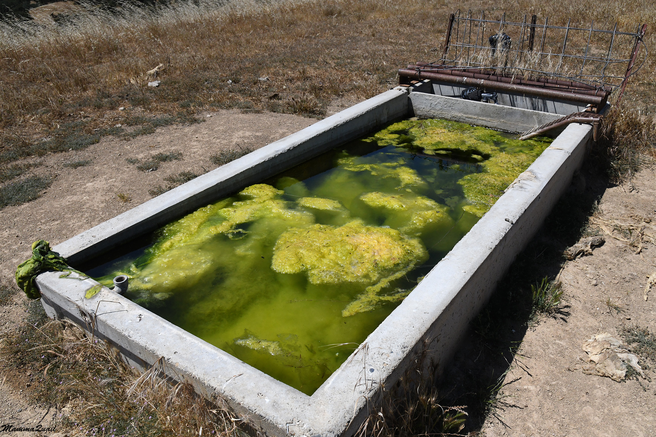
I went near the trough and looked inside. There are creatures that like this kind of standing water. In fact, I was surprised not seeing there mosquito larvae.

I sat at the edge of the trough and removed spikes from my shows, wondering what to do next. I had the choice of looping back right there, which is what I would have done had I led families on this hike. By then however, I came to the conclusion that this place would be unsuitable for a family hike in July. I looked at my watch and decided I had plenty of time to make this a longer, personal hike. Instead of turning north to loop back I turned south on the Spikes Peak Trail and resumed walking towards Spikes Peak.
 |
| Spikes Peak Trail |
From the heights of that ridge I had a very nice view of San Luis Reservoir. Like a blue gem it shined between the golden hills.
 |
| San Luis Reservoir |
There were more wildflowers along the Spikes Peak Trail. Many of them in the DYC category - damn yellow composites, which I've already given up on identifying.

But the best wildflower sighting there was the butterfly Mariposa lily. There were quite a few of them, actually, each one more beautiful than the other. These flowers were at their peak bloom. All of a sudden I no longer minded the thorns in my socks.
 | |
|
Ahead of me was a cattle gate, and behind it - the cattle. Cows were the only animal species from which I've experienced hostility and threat during my hikes. I learned to respect them and give them space. Here they were right on the trail though, blocking the gate. I approached carefully, sending them positive thoughts and talking softly. They didn't give me any problem and I moved on.

It was later that I realized that I missed the turn on the Up and Over Trail that I planned to take down off the ridge because the cows blocked my view of the trail sign. Thankfully, the next downhill trail wasn't too far ahead. Anyway, I didn't want to go back and push my away again through that herd.
 |
| California Poppy, Eschscholzia californica |
This was an excellent year for the California buckeye. They were fewer than the oaks in the park, but they stood out brilliantly with their chandelier bloom look.

In the dry grasses I saw another lupine species - the bicolor lupine. It's a common one, but usually blooms much earlier. I must have found the last blooming plant in the park that day.
 |
| Lupine, Lupinus bicolor |
Not to far up the trail I saw an entire patch of bush lupines in bloom. They were already past their peak bloom, but they still had many open inflorescences, and it was lovely to see.
 |
| Silver Bush Lupine, Lupinus albifrons |
My high place on top of the ridge gave me a view point not only east to San Luis Reservoir and the Central Valley, but also west to the other peaks of the Pacheco area, including Pacheco Peak, which isn't part of the park.
 |
| Pacheco Peak |
I reached the junction with Shadow Springs Ridge Trail which was the trail I needed to take down in order to loop back. By then however, I was quite close to Spikes Peak and it seemed a shame if I didn't make it to the top before heading back so I passed the trail junction and continued toward the summit. A vulture circled over my head for a bit, then flew away.
 |
| Turkey Vulture |
At the summit I found yet another picnic table and I sat down for another snack break. The table was in the shade of a large oak tree. The wind was quite strong up there and soon I had to pull my jacket out of my backpack and don it. I had a nice view there of the mountain in the south, the one I'd probably never visit.
 |
| View south from Spikes Peak |
After a short and surprisingly chilly break I turned back north on Spikes Peak Trail. It didn't take long, walking in the sun, before I took my jacket off again. I found there other blossoms of the purple clarkia, this time truly purple flowers, fitting their name.
 |
| Purple Clarkia, Clarkia purpurea |
Back at the trail junction with the Shadow Springs Ridge Trail I paused and looked down in the direction I was going to go. I noticed another little body of water there - Nun Lake. A quick check of the map showed me that I won't be going near that pond so I settled for a long distance shot.
 |
| Nun lake |
The trail downhill was very overgrown with weeds, even more so than the Tunnel Mountain Trail. The thorns in my socks upgraded from nuisance to a serious pain in the rear, and there were fewer spots where I could conveniently stop to clean my shoes. I gritted my teeth and tried to ignore the spikes, focusing on the beauty around me.
 |
| Pacheco Peak viewed from Shadow Springs Ridge Trail |
Sure enough - the beauty was there. I came across another nice patch of the butterfly mariposa lilies and lingered there for a few minutes, appreciating their beauty and perfection. The little bugs that pollinate the lily were also very appreciative of its perfection.
 |
| Butterfly Mariposa Lily, Calochortus venustus |
At some point I crossed the county line again and was back in Santa Clara County. A bit further down I saw a different kind of perfection - a patch of chamise in full bloom. This common chaparral bush looks ordinary most f the year but when it blooms it fills up with gazillion of little cream colored flowers that give it a very cloud-like fluffy looks.
 |
| Chamise, Adenostoma fasciculatum |
This has been a very good year for the chamise as well. After I passed the chamise patch I turned around and looked at it from below - the color contrast with the golden hills and the dark oaks was simply stunning.
 |
| A patch of blooming Chamise, Adenostoma fasciculatum |
near the bottom of the Shadow Springs Ridge Trail I finally found a place to sit below a large oak tree. I took my shoes off and cleaned my socks thoroughly, hoping that I won't have to do it again on this hike.
 |
| The Interior of a live Oak, Quercus wisnizeni |
Across the trail on the remains of a less fortunate oak, a family of squirrels looked at me and kept shouting their warning calls. After cleaning my shoes and resting for a bit, I relinquished back their territory and moved on.
 |
| California Ground Squirrel |
I turned north on Whisky Flat Trail and found it wide and flat, and I was glad that for some time I didn't have to worry about the thorns.
 |
| Whisky Flat Trail |
Very quickly though, the trail was no longer flat. I came upon a tiny springs pond near the trail. The water wasn't enough to truly flood the trail, but there was a short muddy section there that I needed to jump across.

There were tadpoles in that pond. Not many, but enough to continue the next generation of frogs there. They were hiding in the vegetation but I managed to capture one.
 |
| Tadpole |
A third of a mile up Whisky Flat Road I had to pass a cattle gate after which the nice dirt road continued in an off limits private land and the trail I was hiking on remained a very narrow foot path inside the barbwire fence that marked the park's boundary on the west. Sure enough, I had thorns in my socks again.

The strong winds that kept me cool on top of the ridge were non-existent here and the day grew hot by the minute. I estimated my water and decided I should better limit my hydration to stretch my water to the end of the hike. I also started looking for shade along the path where I could take short, refresher breaks.

As if to annoy, it was a good, hot distance before I found a suitable place to take a break. Even there, I was surrounded by thorny plants and had to be really careful as I moved through the vegetation. On the other hand, there was enough leftover moisture there under the trees to support some late monkeyflower bloom.
 |
| Seep Monkeyflower, Erythranthe gutatta |
Whisky Flat Trail is the classic way back trail. It wasn't very interesting, not featuring anything special, and not providing any grand views because it was deep in the valley. On top of this, I had the ugly barbwire fence on one side, and a nice, weeds free dirt road that I couldn't access on its other side. Unfitting its name, Whisky Flat Trail wasn't even flat. In fact, it was undulating up and down and I followed the curves, leaving a trail of sweat drops which dried almost instantly.
 |
| Whiskey Flat Trail |
On the other hand, there were numerous beautiful or otherwise interesting trees growing along the trail. California buckeye trees in full bloom and strangely-shaped interior live oaks. There were also some wildflowers here and there, but nothing new or prettier than what I saw earlier on the hike. I was hot, tired, and thirsty, and ready to complete the hike.

One of the problems I sometimes encounter on my hikes is the appearance and inconvenient disappearance of makeshift trails. usually I'm good telling the main trail from the rogue ones, but this time I did end up going down the wrong path and I found myself pushing again through thorns, path finding my way along the park's boundary, until I eventually made it back to the place where the formal trails came together near the park's entrance.

When the main park's road was in sight I pulled my water bottle out and ceremoniously finished the last drop. I them made it quickly back to the trailhead where I took a great pleasure in switching to open toe sandals. Later at home, I would spend a long time picking out all the remaining thorns from mt socks and shoes.
 |
| Back to the trailhead |
Pacheco Park has some of the prettier landscape views of the California Coastal Range, and some of the prettiest oak trees I've seen. In spring time this park has a great wildflower scene, and some gorgeous, family friendly walks. Summertime hiking there though, is more for the hardcore. Much water should be carried, and high boots are highly recommended if you do.