

 |
| Sunrise at Guyot Creek |
While going through my morning routine I saw the first hiker coming up the trail. I recognized him as one of the older men who were relaxing at Rock Creek camp when I made my way through. He didn't even grant me a glance and perhaps he didn't even notice I was there at all. He was going fast and seemed to be carrying very little - a minimalist backpacker. I thought about how much non-essential weight I was carrying as I packed my things and got ready to move in the same direction the other hiker went - to the north and up Guyot Pass.
 |
| My hike as captured by my GPS |
From Rock Creek camp to Guyot Pass is nearly 1000 ft of elevation gain, and I ascended about half that height on my last push yesterday. Now I needed to continue up and over Guyot Pass.
 |
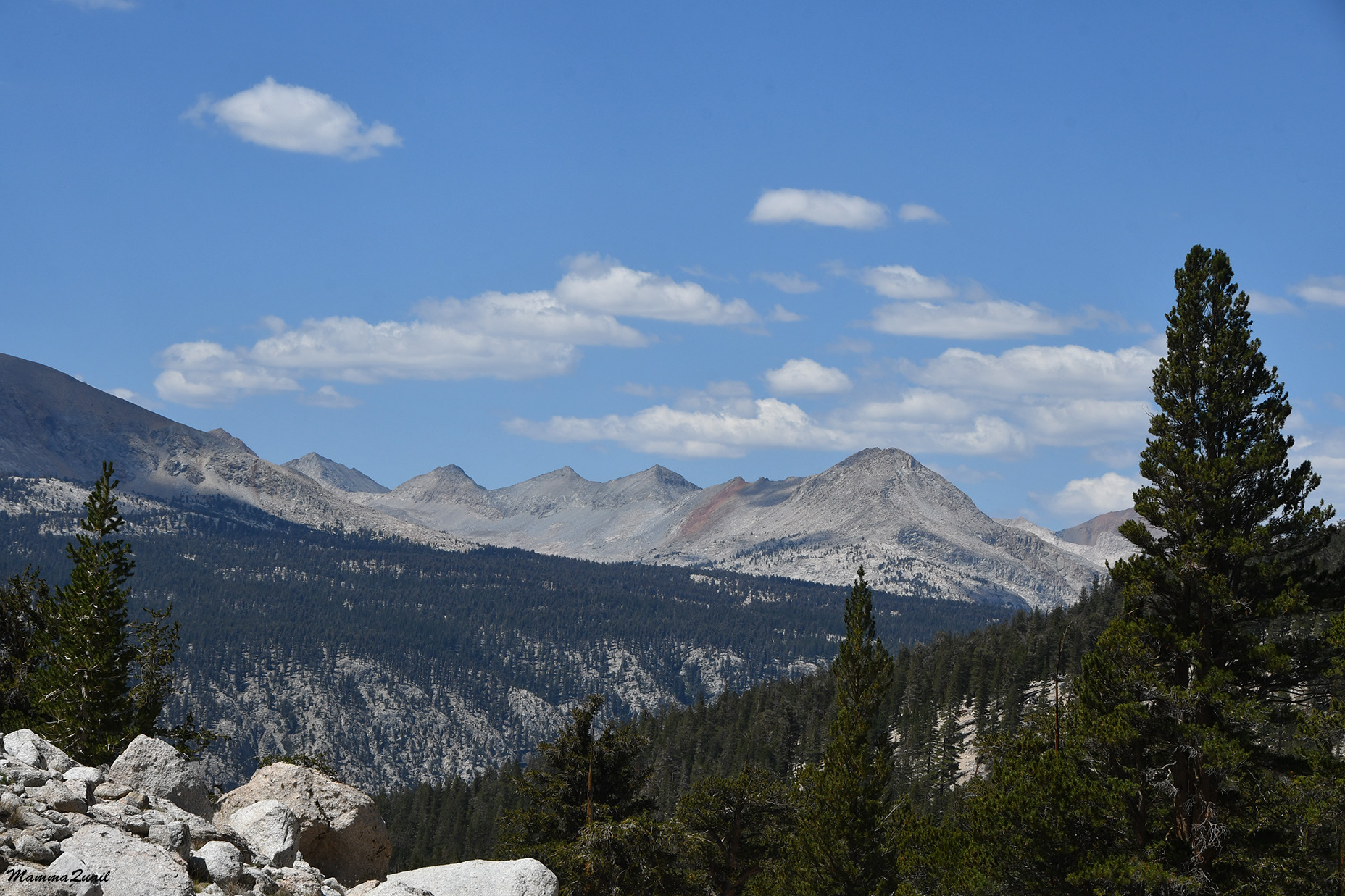
| John Muir Trail, north bound |
The trees, all foxtail pine, were fewer and there was more distance between them. Guyot Peak to the west was fully visible and very beautiful in the morning light.
 | ||
| Guyot Peak |
after a straight and relatively mild uphill stretch the slope became much steeper and the trail turned to switchbacks. This trail was made suitable for mules and horses so at no place was it very steep. With a good morning energy I made it up at a good pace.
 |
| John Muir Trail, north bound |
I took my first break at Guyot Pass. Looking south to where I came from I saw that round peak across the valley of Rock Creek.

To the northwest was a fast, forested valley crowned with rugged peaks. I still had no view to the northeast where Mount Whitney was.
 |
| View northwest from Guyot Pass |
All the peaks surrounding the valley were in various shades of gray but one of them, which had a large line of red rock running from top to bottom. It really stood out against the gray granite. 
On my descend down the north side of the pass I met the next hikers on this trail. They were going south and there was a big gap between the first two and the last one. They used loud howls to communicate their position and while I understood the need, it did hurt my ears.
 |
| John Muir Trail north bound |
The trail was descending on the western side of the slope and remained high above the valley floor and the meadow even after the slope eased and leveled. The meadow looked drying and I couldn't see any wildflowers there from where I was. I did see many young pines striving to be a forest.

West of the valley there were some really rugged, pointy peaks poking through behind the trees. I was sure I've seen them on last year trip from Black Rock Pass but I didn't recognize them by name.

The two backpackers that I talked with the day before described to me the trail between Rock Creek and Crabtree, which was where I originally planned to camp on my forth night. They told me that the area would be dry and that I should fill up on water before heading out. They also told me that the way was forested with 'red-barked cedars'. Thus didn't sound right to me but since I didn't see the trees yet, I didn't argue. Nw that I was walking between these red barked trees (occasionally sipping from the water I collected at Guyot Creek before heading out) I knew that I was right - these were no cedars at all but the familiar High Sierra kings - the foxtail pine.
 |
| John Muir Trail, north bound |
As the trail undulated mildly along the mountain side I got to have a better view of some of the peaks surrounding the valley through occasional openings in the forest. I also saw more hikers, almost all of them were going south on the trail. Some stopped to chat a bit but most of them merely nodded to me and continued walking without stop. A couple passed me from behind on their way north, the same way I was going. Way exchanged hellos and they continued on at a faster pace than mine. There were a few solo hikers too, like me, and nearly all of them were women. I didn't ask but I wondered if that was the case because women preferred to go alone, or that women have a harder time finding a backpacking partner, as was the case with me.

I was due to go over a small ridge before descending into the valley of Crabtree creek, and I decided to stop for a break before getting up there. I found a fallen log off the trail and I sat there to snack and to rest. The day was getting hot and I checked my water - I still had plenty. It was nice to relax in the shade but eventually I had to get up and go. I was prompted by the sound of humans coming from behind me and I wanted to get going before they catch up to me.
 |
| John Muir Trail, north bound |
The broad view photos show dry, empty soil between the pine trees but there were plants growing there in the granite gravel. Tiny plants that blended in the gray background. Some were blooming too, but I needed to stoop low to get a good look at these tiny beauties.

Other were a bit larger and easier to see and to identify. It was nice to recognize plants that I've seen on previous trips in the area. It was like meeting old friends.
 |
| Sierra Beardstongue, Penstemon heterodoxus |
I walked slowly up the short switchback trail to the ridge. There were too many trees there to see the view but as I was making my way downhill the trail curved east and through the trees I saw a bit of Mount Whitney! I was very excited, although I couldn't get a good clean photo of the mountain, there were too many trees in the way. At a bout that point the group that came up behind me caught up with me. There were about 8 men in that group. most of them looked in their 30's or 40's, one looked young adult. They were chatty and energetic and when I told them that I would be going up Whitney they said that that was their plan too. They passed me too, going fast down the trail.
 |
| Squirrel Tail Grass |
Further down the trail I finally got a clear view of Mount Whitney, visible through the opening of the Whitney Creek canyon.
 |
| John Muir Trail, north bound |
I zoomed in on the creek's opening to get an enlarged view. My heart raced with excitement and apprehension. I wanted to go up there but upon seeing it, so steep and high, I felt a wave of panic coursing through me. All of a sudden all my self doubt returned.
 |
| Mount Whitney (left) |
Either way I'd have to go up, at least to the Whitney Crest in order to exit the wilderness. The crest was at 13,500 feet. My final decision whether to summit or not would be there, and it would not be today. I took a deep breath and continued down hill toward Crabtree Meadow.
 |
| John Muir Trail, north bound |
After a morning of them being quiet, on the way downhill I started to feel my blisters again, despite having the special blister band aids on. So although I was going downhill on a mild switchbacks trail I had to slow down to minimize the friction of my feet with the shoe fronts.

 |
| Sargent's Campion, Silene sargentii |
I also had a nice view at a different angle of the red-streaked mountain that I saw on my way down from Guyot Pass.
On my way down I also came upon the couple that passed me earlier on their way north. They were having their lunch break sitting in a nook under a large pine and looking at the horizon. This time it was me who stopped to chat. We talked a little more and they told me that they had started at Horseshoe Meadow where they'd spend a night to get acclimated to the altitude and they were going north on the JMT. They were debating if to make an excursion and climb Mount Whitney. Unlike me they would make it an in and out day hike leaving their camping gear behind while I'll need to carry everything over Whitney's crest to the eastern side. They too had their reservations about their ability to ascend all the way up.
 |
| Agoceris sp. |
I moved on first but it didn't take long for the couple to pass me on their fast way down. As they passed me I told them that we'll see each other again at Guitar Lake's campground. I think it was the point where I was finally committed to go all the way to Whitney's western base camp at Guitar Lake that day.
 |
| Naked Buckwheat, Eriogonum nudum |
 |
| Crabtree Meadow |
Because I arrived Crabtree Meadow at lunch time and I felt fine I knew right away that I would not camp there that night.
 |
| Fleabane, Erigeron sp. |
It was lunch time and I looked for a place to stop. The best spot south of the creek was occupied by the group of men that had passed me earlier. I looked around but didn't see the other couple that I've met on the trail and I assumed they have moved on. I crossed Crabtree Creek and I sat on a nice plat granite slab that was well shaded, and pulled out my daily food bag.
 |
| Crabtree Creek Crossing |
From where I was sitting I had a nice view of the creek and the drying meadow near it. I thought about how the impeding ascent of Mount Whitney has taken over my mind and about how stressed I was because of it. Unlike previous trips where I was relaxed and felt free to go wherever I wanted, to push on or to stop whenever I felt like, on this trip all my thoughts and my energies were focused on the Whitney ascent. Nearly all my decision making during this trip was skewed by the summit goal. I didn't like that feeling, it affected my enjoyment of this trip.
 |
| Crabtree Meadow |
I could have turn around and hike some other loop trail that would take me back out of Horseshoe Meadow. Why not? I wouldn't be less of a hiker for it, right? But logic has nothing to do with it. Inside my mind I was already committed to ascending Mount Whitney and I would feel worse if I turned away for any reason other than physical impairment or altitude sickness.
 |
| Groundsel, Senecio |
The John Muir Trail overlaps the Pacific Crest Trail for a good length of the Sierra Nevada Range through Yosemite to Sequoia National parks and the area in between. Less than a mile north of Crabtree Meadow there is a spur of the JMT that juts east to Mount Whitney, all the way up the crest and to the summit. Backpackers going on the JMJ can hike up Mount Whitney with their JMT permits as long as they go back down the west side. I needed to get on that trail myself but I took the shortcut Crabtree Meadow Trail rather than sticking with the JMJ.
 |
| Crabtree Meadow Trail |
Sometimes I see things along the trails that have me raise an eyebrow, such as this old, rusty horseshoe hanged on a horseshoe-like piece of wood like an omen of sorts.

I don't know an omen of what it was, but when I resumed my walk after lunch break I felt suddenly tired. More tired than I should have been after a nice, long break. The trail was going uphill along what was now Whitney Creek, but at a mild enough slope and I was walking slow enough to not push myself too hard.
 |
| Whitney Creek |
There weren't too many wildflowers along the trail and the flowers that I did see were blooming mostly near the creek. I did see a butterfly resting on the rock by the trail side.

Crabtree Meadow Trail starts in the meadow along the north bank of Whitney Creek. Abouth half way to the Crabtree ranger station where it connects to the JMT Whitney spur the trail crosses to the south bank. At that point I was overtaken by the group of men that I met earlier on the trail above Crabtree Meadow and that I saw last eating lunch and resting by Crabtree Creek. Now I could tell that they had a leader to the group, perhaps he was their guide. Neither of us stopped but he did slow down and fell behind his group because when I realized that he was experienced with Mount Whitney I kept asking him questions about what awaited me there.
 |
| Whitney Creek |
He reassured me that I should have no problem finding a camp site at Guitar Lake despite it being the western base camp for many who climb Whitney from the west. He also reassured me that the trail up Mount Whitney was clear and easy to see and follow in the night's darkness. That was an important point because I had planned to start my ascend in the wee hours of the night. He also warned me about the marmot that was nibbling the backpacks that people were leaving unattended at the summit junction. Naturally, that was exactly what I was planning to do - to leave my backpack there while going for the summit. I learned that I should remove the bear canister and leave it outside the backpack.
 |
| Cinquefoil, Potentilla sp. |
The group continued on, leaving me behind to walk at my slow pace. I caught up with them again at the creek crossing by the connection with the JMT spur. I sat down to filter some water and to rest a bit before moving on east, and they were going back and forth from the creek to the location's camp site. They were planning to stay right there and start for the mountain at around 1 am. The group leader suggested that I should make it to the summit by sunrise, to which I replied with a good lough. There was no way I was going to make it up there that fast, not while carrying a heavy backpack, even if starting from Guitar Lake.

I thanked the group leader for all the info and good advice. We said farewell and I hoisted my backpack and started east on the JMT/Mt. Whitney Trail.
 |
| John Muir Trail, Whitney spur, east bound |
At first I walked through a pine forest. A mixture of foxtail pines and another species which I didn't recognize. Some distance later I stepped out into an open bare granite plateau. The mild slope suited me because I was getting tired. I had about 2.5 miles of an uphill walk left, and I knew that some of it will be steep. I saw the big granite wall of mountains ahead of me and once again felt the pang of fear. I pushed it away and continued on.

For the most part I was alone on the trail but I could tell that many people had walked the same path recently. There were many, many holes at the sides of the trail, holes made by countless hiking poles, a silent evidence of this trail's popularity. I was adding my own set of pole holes in the ground.
 |
| Traffic Marks |
Not wanting to carry too much weight, I filled only one bottle at the creek crossing and by the time I neared the creek again my bottle was nearly empty, so I stopped to fetch and filter some more water and the nearest creek access point.
 |
| Whitney Creek |
At Guyot Creek where I stayed last night were lots of pine bolete mushrooms dotting the forest floor. The bolete in the photo below however, was the only one growing in that spot by Whitney Creek, and the last one I saw on this entire trip.
 |
| Pine Bolete |
Another small ascent and I was walking through a small, beautiful meadow, nestled between bald peaks. Light clouds were drifting across the sky and each time one of them blocked the sun the temperatures dropped.

Still ahead of me and south of the trail was a low ridged mountain with an interesting erosion pattern. Just below it was a high rocky ledge and I realized that soon I'll be ascending it.
 |
| Mount Hitchcock |
Ascending that ledge was slow. I was getting weary from the day's walk and the altitude, while not making me sick, did make my tire easier. I paused frequently to catch my breath and on one of these pauses I turned around to look behind be at the pretty meadow I just walked through.

A few hikers were descending down the trail, nodding to me as I stepped aside and let them pass me. Many of them carried only a light day pack but some had a full backpack load on. They all looked weary and very few of them smiled, which worried me a little.
 |
| Woolly Groundsel, Packera cana |
I moved higher up the ledge and once again into a grove of trees, which were now only foxtail pine. The day was no longer hot and a light, chilly breeze started picking up. As long as I was walking I was okay and didn't feel the need to wear another layer, but on each pause I took I felt the goosebumps form on my exposed skin.

There were more wildflowers on this part of the trail. I was getting close to 11,000 once more and for the plants of these heights it was still the height of the bloom season. Some of them stood out really nicely against the granite backdrop.
 |
| Wavyleaf Paintbrush, Castilleja appelgatei |
Other wildflowers blended with the light gray background, making it harder to see and photograph them.
 |
| Naked Buckwheat, Eriogonum nudum |
There were also more butterflies abound in that area, and the developing chill was affecting them too because many of them were flying sluggishly and when they landed they were less quick to fly away when I photographed them.

The trail followed Whitney Creek upstream. Sometime close and sometime further away. At one place the creek and the trail were one and I needed to carefully avoid the mud.

A flash of color ahead got me excited enough to almost run. Well, not exactly run, I don't think I could have done that even if my life depended on it at the time, but I sure forgot my fatigue for a moment. It was a mountain pride penstemon that I saw. Two small bushes of that penstemon, the only plants of this beautiful species that I saw blooming on this trip.
 |
| Mountain Pride, Penstemon newberryi |
The slope steepened and I continued huffing and puffing uphill. On the granite outcrops the hiking poles were useless and I merely dragged them behind me. More clouds collected in the sky and the air had a real chill to it now.

I reached Timberline Lake, a small lake close to the trail. There was faded sign there stating that camping was prohibited there. The sign was stuck at the place most suitable for pitching a tent. I had no plans to stay there and I didn't need to refill my water yet, but I did sit down for a short snack break, hoping that the energy intake would help me make better progress.
 |
| Timberline Lake |
I was over 11,000 ft in elevation now and I still had a thousand feet more to ascend, and that on a trail stretch of about 1.5 miles. More and more clouds were coming from the west and they were bigger too.
 |
| John Muir Trail, Whitney spur, east bound |
As I was getting ready to move on a little butterfly passed in front of my eyes and landed on a nearby tree. The butterfly hanged below the branch and didn't move when I approached to take a photo. It must have been too cold to fly away.

I was feeling the chill as well but I figured I'd keep warm by walking. Past Timberline Lake I met two young women making their way east, carrying full backpackers load. They told me that they had stayed last night at Guitar Lake and climbed Mt. Whitney earlier today carrying only a light day pack. Upon descending back to Guitar Lake they packed the rest of their gear and now going further east to camp at Crabtree.
 |
| Whitney Creek |
That was a strategy I have thought about too. To stay at Guitar Lake for two nights, leave my gear at there and hike up Whitney as a day hike. The problem was that I would have to go up the crest again to 13,500 ft because I had to go east eventually. So either way I'd have to howl my backpack up most of the Whitney trail. I quickly dropped that idea.
 |
| Grayswamp Whiteheads, Angelica capitellata |
The two young women were weary but looked happy and satisfied. I envied their youth and the ease in which they walked. I knew these thoughts wouldn't get me in any better state of mind so I tried pushing them away and enjoy the beauty surrounding me.
 |
| Sierran Woodbeauty, Drymocallis lactea |
I was passing south of Hitchcock Mountain and now I could pay closer attention to the interesting erosion pattern of its south-facing slope. It looked like sharp horizontal fins that stick out of the mountain's south side. I think it might be the effect of snow and ice melt.
 |
| Mount Hitchcock |
It was getting late but I still needed to go up about 500 feet more. On my way up the rock ledge above Timberline Lake I came upon a group of people descending from the mountain on their way west. They were all carrying light day packs and I assumed they camped somewhere down stream Whitney Creek. Most of them were older than me. People in their 60s or 70s even. All of them looked thin and fit and I could only wish that I'll be this fit when I'm at that age. What surprised me was to see that they all wore short sleeve pants and shirts. I was already cold enough to wear my wind breaker and I was the one going uphill. It occurred to me that I was feeling cold because I was also very tired.
 |
| Mount Whitney on the right side of the photo |
The chill didn't affect the high altitude wildlife. A busy ground squirrel granted me a curious look and continued foraging without letting me interrupt him.
 |
| Golden Mantled Ground Squirrel |
I was very tired by now. I was short of breath because of the altitude and the exertion, and I was going very slowly, pulling myself up the trail by will. But then I looked back to see how far up I got and I saw three backpackers way below the ledge, making their way up in my direction, I got suddenly fueled by new resolve and started striding up the last lag of the trail to Guitar Lake. In my mind I wasn't about to let them gain on me and take what was possibly the last good camp site by Guitar Lake. Silly, I know, but for a short time this thought did boost my energy enough to move forward at a better pace.

A patch of large, lush groundsel plants on full bloom decorated the upper part of the trail and made me smile. Despite my sudden urgency to get to the campground I paused to appreciate their beauty.
 |
| Fremont's Groundsel, Senecio fremontii |
Tiny meadows matted the alpine valley I was walking through, and marmots strolled in the grass, munching at the vegetation. One of these marmots was very close to the trail and just like the squirrel, was completely undisturbed by my presence there. I guess these animals are all too used to seeing humans walking through their territory.
 |
| Yellow-bellied Marmot |
Clouds were coming and going still and for a brief moment a hole in the cloud let the western sun illuminate the side of the mountain ahead. It looked like the mountain was frowning at me. Good thing I'm not prone to superstitions.

Where was that lake? I felt like I was walking forever, and still no sign of Guitar Lake. According to my navigator I should be seeing it at any moment. I was making my way up the last few yards between small and stunted whitebark pines, a high altitude tree that hardly gets any taller than human height at these elevations.
 |
| Whitebark Pine, Pinus albicaulis |
Finally! Guitar Lake came into view. This lake is named so because of its guitar-like shape. On the map it's pretty obvious but from my stand point it looked like a simple, round lake. The lake area looked barren at first sight, but then my eyes detected the colors and movements and I gasped - the entire lake shore was like a tent city. There were so many people camping there!
 |
| Guitar Lake |
Half stumbling I made my way down to the lake. I crossed Whitney creek on my way - so small and narrow it was here, at its source. I could cross it with a single hop.
 |
| Whitney Creek |
As the leader of the men's group that I met earlier said, there was plenty of space to pitch a tent there by Guitar Lake. What wasn't there was any possibility of privacy. The tents were pitched very close to one another. There were also very few places around the campground that provided a hideout for toilet, which worried me a little, before I realized that once darkness fell, finding the perfect hideout didn't matter anymore .
I pitched my tent and cooked ate dinner. I wanted to be fully prepared for the climb so when I wake up I wouldn't waste any unnecessary time in preparations. When I went to fill my bottles at the creek I recognized the couple I had met earlier that day above Crabtree Meadow and I came over to say hello. We chatted a bit, and they told me that they planned to start hiking around 4 am. I had my alarm set for that time too. I was hoping to get a good night's sleep that night but I doubted that I'd get it because there were so many people around. Just as I was ready to get inside the tent another backpacker arrived and pitched his tent right next to mine and he was noisy with his evening routine much after I was already inside my sleeping bag, attempting to sleep.
 |
| Sunset at Guitar Lake |
But there was something else keeping me awake. I tossed and turned, troubled by thoughts about the feat awaiting for me tomorrow. I admitted to myself that I was afraid. What if I couldn't make it? What if my body failed me? Would this be a downhill slide toward senescence? I calmed myself by quietly thanking my body for carrying me so far and expressed my trust that it would carry me up the mountain, all the way to the summit. Before I went out on this trip friends have wished me to successfully 'conquer the mountain', but now I had a very different state of mind: I wasn't going to conquer Mount Whitney. I was going on a date with that majestic mountain. I was going to meet it, meet myself, at the summit tomorrow. And with that thought I drifted to sleep.