

Date: August 29, 2022
Place: Golden Trout Wilderness, Lone Pine, California
Coordinates: 36.459808, -118.163577
Length: 4.7 miles
Level: strenuous
The academic year of 2021-2022 was rough for me. There were too many things going on, and too many injuries I've sustained that prevented me from keeping in shape. My summer was very busy too, with family visits and road trip which were a lot of fun but filled all of my time and took most of my energy. Knowing that I won't have time this summer for a long backpacking trip I tried to sneak in a short one just as summer started. I went with a friend to Snow Mountain to what was planned to be a two-nighter trip that ended up to be only one night because of weather. And I resigned to the thought of not doing a Sierra Nevada trip this year.
But when all of my summer travels where over and the school year started I noticed a week long 'hole' in my schedule. I included the Labor Day weekend but after this busy summer none of my family members wanted to do anything special on that weekend. I jumped on the opportunity and on the day I made up my mind to go, I booked a permit and started planning the route.
A booked my permit to the Golden Trout Wilderness - to the same entry area of Horseshoe Meadow/Cottonwood Lakes where I started my first solo backpacking ever, on 2017, only this time I the permit I had was for the Cottonwood Lakes Trailhead. At an impulse, I booked the exit point to be the Whitney Portal, and from that moment on, my thoughts and energies were enslaved to the idea that I was going to summit Mount Whitney, the tallest peak in the contiguous USA.
Having planned my trip with a different exit point from where I was beginning, I needed to plan also how to complete the loop. This was salved by parking my car in Lone Pine (the Film History Museum rents out parking spaces) and taking the shuttle of Lone Pine's Chamber of Commerce to the trailhead.
 |
| My hike as captured by my GPS |
The shuttle driver was a very experienced woman who knew every bit of road in the Eastern Sierra. She was also very busy that day and I could book my ride only for 2:00 pm, which gave me a couple of hours in town to eat lunch and finish getting ready. It also meant that I was starting my hike much later than I had thought I would. My original plan was to get to Cottonwood Lake #1 for the first night but given the time I had and the uphill walk at an already high altitude, I figured I'd stop sooner, and I hoped I'd find a suitable place for that.
 |
| At the Golden Trout Camp Trailhead |
My trail begun at about 10,000 ft and as soon as I begun walking I could feel the altitude. I would go up about a 1000 ft more today, and I hoped that wouldn't be too much to start with. I soon found some late summer wildflowers and put the worry thoughts out of my mind.
 |
| Oval-leaved Buckwheat, Eriogonum ovalifolium |
On ,y previous trip at the Golden Trout Wilderness I entered at the Horseshoe Meadow trailhead. My current permit was for the Cottonwood Lakes trailhead which is in the same area, with the trail going over Cottonwood Pass, the one I returned on on my last trip. This time I had the shuttle driver drop me off a but earlier on the road, at the trailhead of the Golden Trout Camp Trail, which follows Cottonwood Creek. The trailhead was not marked but there were a few cars parked near it The trail was clear to follow though, but I did need to bypass a few fallen logs though.
 |
| Trail |
I was glad to see wildflowers along the trail. At the end of August, and on the second severe drought year in a row, I didn't expect so see much bloom. There were no carpets or large patches of wildflowers, but there were some, most of them perennial shrubs.
 |
| Wavyleaf Paintbrush, Castilleja appelgatei |
A wood sin nailed to a pine tree trunk heralded my entering the Golden Trout Wilderness. On my previous trip here I had to deal with some mental issues, some having to do with that trip being my first solo backpacking trip, and some having to do with altitude effects which I took a bit too long to recognize and mitigate. This time I was going solo once again, but after having that experience a couple more times since. I was also more experienced now in identifying the altitude effects and I had a good strategy to deal with that.

What I didn't have on this trip was proper fitness. Because of my recurring injuries last year I had fallen out of shape, and although I was working out to get fit, I was nowhere near the condition I was at on the previous summer, when I went hiking up Mount Shasta. And I could feel that with every step uphill.

I was glad to see wildlife along the way. Squirrels and chipmunks were out and about and occasionally one even sat still long enough for a photo.
 |
| Golden Mantled Ground Squirrel |
Wild flowers gave me less trouble when photographing them. It was nice to see them and they gave me an excellent reason to pause and catch my breath.
 |
| Frosted Buckwheat, Eriogonum incanum |
The slope wasn't steep but the incline was steady and I needed to find the right balance between a quick enough pace so I'd make it to a suitable cap site before nightfall, and a slow enough pace so I won't wear myself down too soon.
 |
| Green Rabbitbrush, Chrysothamnus viscidiflorus |
It was about half a mile into the hike when the trail I was on finally coincided with Cottonwood Creek. The creek was running well but not high, and I was relieved because I would need to cross it soon. It was too soon to worry about filtering water yet so I continued along the trail, looking for the junction that will take me across.
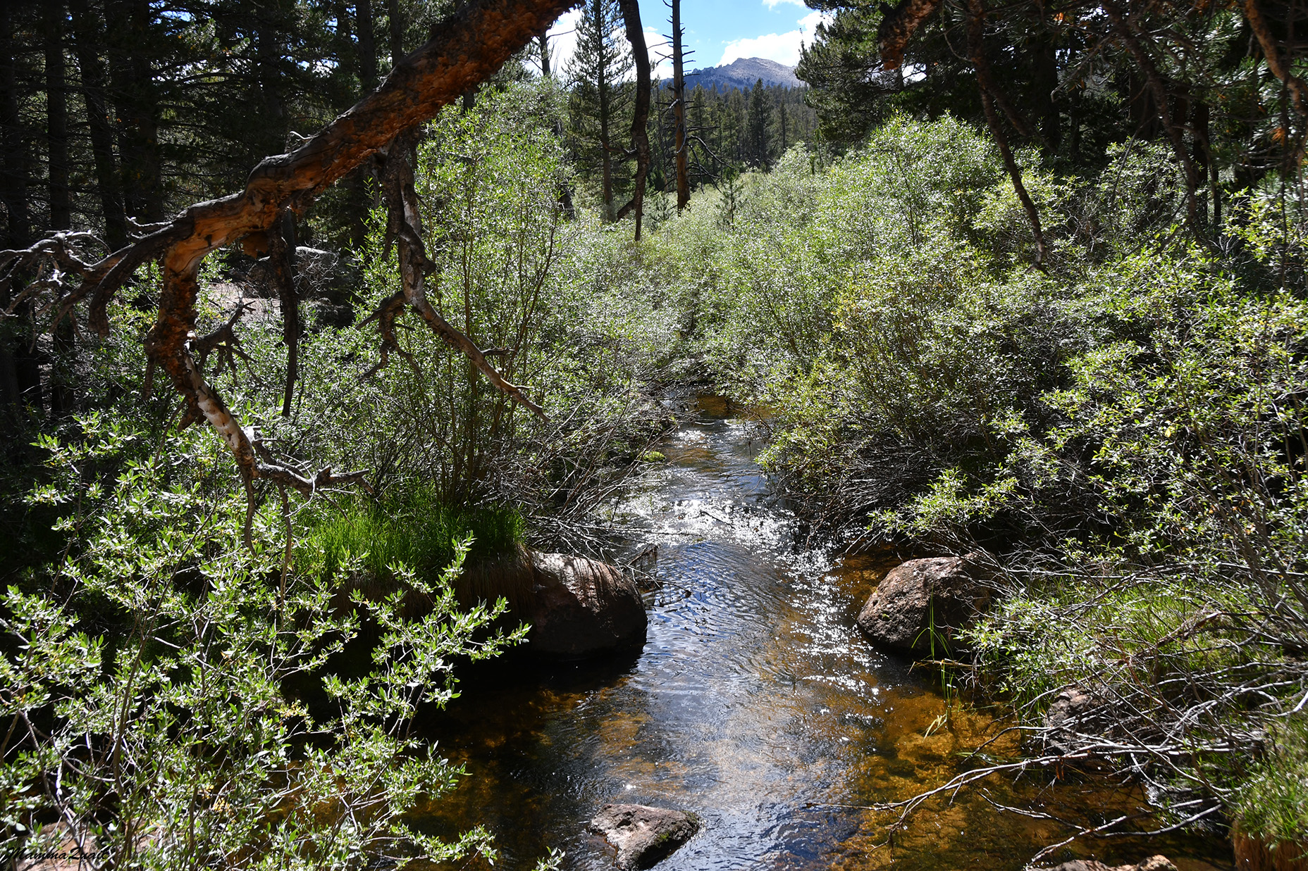 |
| South Fork Cottonwood Creek |
This was an easy part of the hike, walking on an almost level terrain, enjoying the beautiful weather and the solitude. The only time that day when my solitude was interrupted was when to backpackers crossed my path on their way down hill. We nodded to one another, then they vanished down the trail, and I haven't seen any other human for the rest of the day.

The shuttle driver who had brought me up to the trailhead mentioned the past week's thunderstorms in the mountains. The ground was completely dry when I was there, but everywhere around me there were mushrooms, most of them fully grown but haven't yet released their spores.
 |
| Amanita sp. |
I reached the trail junction I was looking for. The junction wasn't marked and I found it only because I reached the place where the creek had forked into its north and south tributaries and the Golden Trout Camp trail was clearly curving to follow the north, whereas a narrow foot path diverged west to follow the south fork of the creek, which was the trail I wanted to hike.
 |
| Cotoonwood Creek riparian zone |
It was a bit challenging to find a crossing point where I wouldn't have to take off my shoes. There were very few places where the creek was accessible through the willow thicket thriving on its banks.

After the creek crossing I was walking in a thin pine forest. The trail became much harder to follow: apparently it was a path rarely used and it wasn't obvious at all where people went before me. It is very likely that whatever foot prints that might have been laid there throughout the summer were washed away by the past week's thunderstorms. Thankfully there were a few cairns here and there, but more often than I was comfortable with, I found myself actively pathfinding, relying on my GPS and compass to head in the correct direction.

The disappearing trail slowed me down considerable, especially at a fairly level area where I could have made a quicker progress. I hope that at some point the trail would improve. Meanwhile I admired the huge bolete mushrooms that grew in that forest in great numbers and to an unbelievable size. Pine bolete mushrooms are edible and are actually quite good. I was tempted to pick one for dinner but decided against it because I didn't bring the proper cookware and seasoning, and I didn't want to carry a big mushroom with my on top of everything else I was carrying.
 |
| Pine Bolete |
The path opened into a small meadow and disappeared altogether in the grass. I aligned my GPS in the direction of the next trail junction, which was north, and headed straight in that direction.

At the edge of the meadow were a few wildflowers blooming, which at that time I didn't think much of, but when I got to identify them at home they turned out to be almost endemic to that area.
 |
| Twin Arnica, Arnica sororia |
So my off trail experience, while unintentional and distracting, had its bonuses too.
 |
| Field Ivesia, Ivesia campestris |
I was back to going uphill on a pathless slope, adhering to the north direction and to he narrow line of a tiny dry brook, until I finally reached the Cottonwood Lakes Trail, which was very clear and wide. I met it not very far from the north extension of the South Fork Cottonwood Creek Trail, on which I needed to continue.
 |
| South Fork Cottonwood Creek Trail |
The north side of the trail was obvious and easy to follow, thankfully. I tried to make up for the lost time by picking up my pace. That also meant taking fewer photos.

Unless of course, there was something interesting along the way, like this sinking log cabin without any mark of when it was built, who it belonged to and what it was used for.
 |
| Log Cabin |
Behind the cabin run the creek and I followed it on the trail. When the trail crossed a side creek it was in a flooded area of a small meadow. There were step stones placed across on which I hopped. I looked for frogs but I didn't see any.

Sun-exposed meadows are a great place to see wildflowers. The bloom wasn't strong this summer and I was hiking at the end of it too, but there were flowers blooming still and I enjoyed seeing them. Even the most common ones.
 |
| Angelica |
Another patch of forest with some uphill climb, and after that another meadow, this time bigger. It was a pattern that repeated itself several times on this day's hike: an uphill climb through a pretty conifer forest interrupted by flat or nearly flat meadows. And all of that was along the south fork of Cottonwood Creek.
 |
| Meadow |
At the higher meadows I begun seeing gentian flowers. I especially love the blue Sierra gentian, a lovely flower that I only get to see on my Sierra Nevada backpacking trips. There were only a few of them this time, whereas in previous years I've seen carpets.
 |
| Sierra Gentian, Gentiana holopetala |
Under the forest canopy were the little silver cushions of lupine, showing mostly foliage with very little bloom.

I was now going west and whenever I cleared the trees the sun got in my eyes - it was already descending. I was alarmed because I had at least two miles more to get to the first Cottonwood Lake, and that included a steeper uphill section. I quickened my pace a bit.
 |
| South Fork Cottonwood Creek Trail |
The trail curved again and the next time I emerged from the woods I was going north once more and the sun seemed brighter and higher than I thought it was. I couldn't keep up the faster pace for too long. It has already been a long day, stating early in the Hogdon Meadows at Yosemite after a short night, continued with a long drive to Lone Pine and a late start of the hike, and hiking high altitude with a heavy backpack. I was getting tired and ready to make camp.

The next meadow I got too was a long one and the last before the steep uphill rise to the lakes area. For a good long mike I walked at the edge of that long meadow, some distance from the creek. Occasionally the trail would draw nearer to the creek and delved into the trees again. Having set out with all my water containers full, I didn't need to filter any new water yet.
 |
| Long Meadow |
My breaks were short and consisted of a sip of water, and light 2-3 bites snack. I took care not to push myself too fast and hard on that first day. I knew I wasn't yet acclimated to the altitude and I didn't want to trigger any sickness, so I walked at ease. Still, I didn't want to have to look for a campsite in the dark. I already resigned to not getting all the way to Cottonwood Lake #1 for this night's camp, and the camping options I liked at as alternatives were either Cirque Lake or one of the South Fork Lakes which came up sooner. Cirque Lake required a bit of a detour so I decided to aim for the nearest of the South Fork Lakes.

I heard bird calls all through the hike but got to see only glimpses of them as they flew in and out of the vegetation. On the forested side at the north end of the meadow I finally got to meet a less skittish bird and even photograph it - a mountain chickadee, known also for its unique call that sounds like a 'cheeseburger'. This particular bird was silent as it eyed me. It didn't seem to be bothered by my proximity but it didn't sing either,
 |
| Mountain Chickadee |
A small nameless lake was marked on my map at the north end of the long meadow. I briefly considered camping there but when I reached that area I didn't see the lake from the trail. It was separated by a wide stretch of grassy bog area which wasn't suitable for camping. ahead of me was less than a mile to reach the first South Fork Lake so I continued on, and up.

When I started climbing I was still in the sun but the sun was already touching the ridgeline to my west and would disappear soon. I resolved to not have any more breaks until I reached my night's destination. This resolution didn't include pausing to take photos of wildflowers though.
 |
| Mountain Monardella, Monardella odoratissima |
The sun was sinking faster than I could walk and a few minutes after starting my final ascent I was alread in the shade f the mountain. Had I stayed there I wouldn't have seen in again until it rose again in the morning. I could see the line of sunshine moving away from me, progressing faster along the trail and, playing a game with myself, I increased my pace a bit in what I thought was a futile attempt to catch up with it.

My pace wasn't so quick that I hadn't noticed the change in the trees though. I didn't identify the pine trees in the forest I walked through at the lower elevations before reaching the long meadow, but the pines I was walking by now were foxtail pines, which are the signature trees of the High Sierra. I smiled broadly when seeing them for they heralded my passing into the alpine zone of the mountains.
 |
| Foxtail Pine, Pinus balfouriana |
I couldn't believe it but at the top of the ascent I caught up with the sun and enjoyed direct light once more, and also the soft warmth of the evening.

I looked behind me to the long meadow that I left down below me. It was completely engulfed by the evening's darkness by now. I was glad of my decision to climb out of it.

There was only a short distance left to walk to the nearest lake, and it was on a level, narrow trail. I was very tired by now and all I wanted was to find a suitable place near water and make my camp for the night.
 |
| South Fork Cottonwood Creek Trail |
A narrow trail split west from the South Fork Cottonwood Creek Trail toward Cirque Lake. On the way there it would pass by the first of the South Fork Lakes. I took that trail and headed right into Cottonwood Creek, which sparkled beautifully in the angled evening sunlight.
 |
| Cottonwood Creek, south fork |
The creek was much narrower here but I still couldn't cross it in a single hop, not while carrying my backpack. I balanced on a downed log that was placed across the creek and continued to where the lake was expected to be, hoping that it would make a good camp site. While walking I eyed some rocky areas above the meadow as possible alternatives in case I wouldn't find the lake suitable for camping. It was clear to me that I wouldn't go any further than this area today.

I made it to the first South Fork Lake just in time to see the sun touching the ridge line north of Cirque Peak and to capture its setting reflection in the water.
 |
| Sunset at the first South Fork Lake |
I didn't have time to admire the sunset because the light was now fading quickly. In the wilderness it isn't allowed to camp close to a body of water (not that I'd want to - the soil there was too soft and wet) so I went up to the rocky area above the lake in search of a good place to pitch a tent. The best real estate there was already taken by a marmot and I didn't want to spook it so I went a bit further.
 |
| Yellow-bellied Marmot |
If I had some more time and daylight I probably would have found the already established camp site a bit more to the west (I saw it in the morning) but at the time I settled for a flat area near two large boulders and with a big sigh of relief I put down my backpack. My first action was to pitch the tent. It was a new tent which I have used for the first time on the night before in Yosemite. It was fairly easy to build but I still preferred to not do it in darkness.

The next thing was to gather water from the lake. I still had one full bottle of tap water that I carried all the way up from the trailhead but I needed to fill up and filter or boil some lake water. I took my empty bottles and my filter down to the lake where I saw beautiful little clouds trapped in it. The sun continued setting and when I finished collecting and filtering water the lake-trapped clouds had turned gorgeous golden.
 |
| First South Fork Lake |
My camera was sensitive enough to capture my tent as I howled the water back to the camp site, but to my eyes it was almost completely dark by now. It was also getting cold. I pulled out my jacket and head lamp and sat down to cook a quick dinner.

I was completely alone there in the wilderness. From time to time I thought I heard people, perhaps there were campers at Cirque Lake, but I wasn't sure that my mind wasn't playing tricks on me.
I finished up eating and cleaning my cookware, and stashed everything safely away from the tent. I was cold and tired and I needed a long rest so I didn't linger outside after finishing my evening tasks. It was a relief to get inside the tent, to take off my shoes and air my toes, and to lie down stretch. It was almost 9:00 pm when I finally tucked myself in for the night. Tomorrow I'd be going over New Army Pass, which would be the highest point of this trip save for Mount Whitney, and I needed a good night's rest.
You're very brave to take these solo hikes... I would be afraid to do that. The huge bolete mushrooms are very impressive! and the blue Sierra gentian is beautiful
ReplyDeleteOh, I don't think I'm particularly brave. Many do this and It's wasn't my first time either. With good preparation this is quite safe :-) Yes, I love the High Sierra wildflowers, they're very special!
DeleteDear Mamma Quail, I'm a devoted follower of your blog and would like to give you some books and maps related to California hiking. I'm 74 and live in Georgia now, but my kids and grandchildren aren't interested. If I mailed them to the 4H club, would you receive them? I'm not sure how this comment thing works. Can you email me direct?
ReplyDeleteThanks, I'm glad you're enjoying my blog. Thank you for your offer. However, you didn't identify and left no contact info ....
Delete