Monday, December 12, 2022

High Water Celebration of Winter at Sunol Regional Wilderness

Alameda Creek
 
 
Date: December 12, 2022
Place: Sunol Regional Wilderness, Sunol, California
Coordinates: 37.510165, -121.829799
Length: 2.7 miles (1.8 miles without all the diversions)
Level: easy

Not to jinx it, but it looks like we might have a real winter this year. So far at least, the rains were good and I hope they continue like that through April. One of the most pleasing outcomes of the past weekend's rains was that the Alameda Creek got gorgeous flow now. This morning I put off everything I needed to do and went to Sunol Regional Wilderness to check out the flow in its natural path. I walked to Little Yosemite, the short, easy trail that features so much beauty year-round, but particularly so on good winters.
My hike as captured by my GPS

It wasn't all that early when I arrived at the parking lot but I found it empty of cars. As I made my way to the bridge that crosses the creek I saw a number of vans getting through the Ohlone Camp Road gate, which is closed to the general public. The vans belonged to the San Francisco Water Company which manages the reservoir upstream of the park area. One of the men told me that they were going to check the dam. After they passed me I paused on the bridge and gazed down at the fast flow of water below.

Alameda Creek

The morning was overcast but the rains have ceased for the time being. I started up the familiar gravel road but as soon as I passed the first cattle guard I veered right on the first footpath stream access.

Ohlone Camp Road

At the end of the footpath there's a waterhole. Not a hole really, but a wider and flatter part of the creek where at warmer days people like to come to and enjoy the water. Now the usually calm 'pool' was flowing fast and furious.

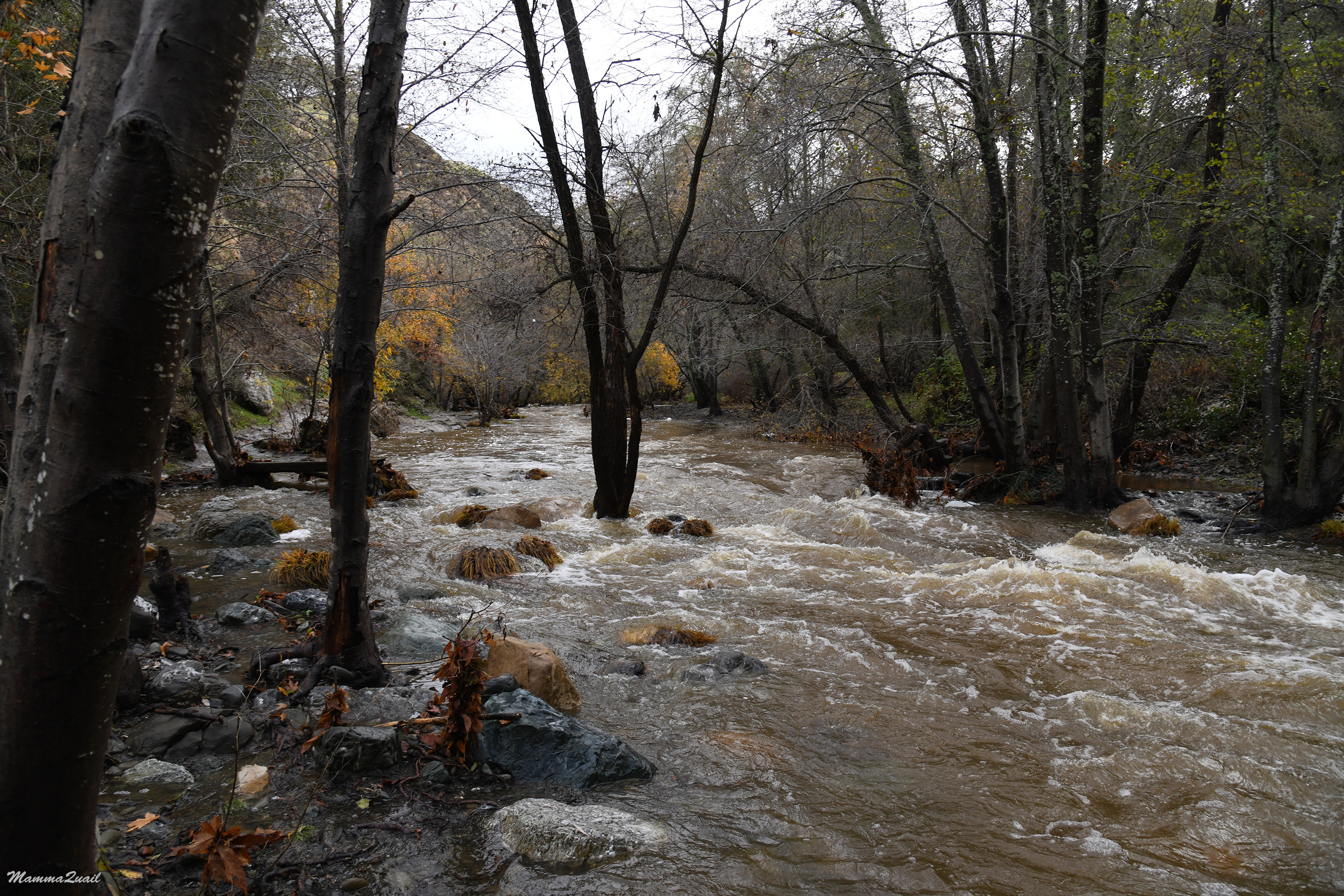
I looked with awe at the gashing whirlpools formed downstream of the waterhole. Running high, this creek could be dangerous. 

At the creek bank in that location there are rocks loaded with fossils of seashells. I walked over to check them out. After being washed well by the rains the fossils looked as if they were embedded there recently. They are about 5-20 million years old though, a Miocene Briones formation.

Fossils

From that location it is possible to walk upstream right along the bank when the water is lower and calmer. Now of course, the water covered the path and I wouldn't have risked it even if I was tempted to step into the cold water.

Alameda Creek

I returned to the Ohlone Camp Road and continued walking up the trail. Most of the trees along the road are oaks and many of them are Valley oaks which are deciduous. Nearly all of them have dropped their leaves already but a few were still hanging on, displaying late fall colors. The other common deciduous trees there, the California Buckeyes, were completely bare for quire some time now. They are the first to drop their leaves.

All around me I heard the loud, raspy calls of acorn woodpeckers. There are many of them in the area, and they were very active. None of them was close enough or stayed put long enough for me to get a decent photo but I did manage to capture one of these beautiful birds as it hanged from the side of a branch. That's the little red dot in the middle of the photo below. Better click on the photo to enlarge it.

Acorn Woodpecker

More water company vans were coming up the road and I started planning in my mind escaped routes in case the dam breaks ... I was mildly surprised that I didn't see any other hikers though.

Ohlone Camp Road

Shortly before the Little Yosemite area there's a bench and a view point near a large rock protrusion. I didn;t stop at the bench but I did go over to the view point and looked up the gulch. The valley cut by Alameda Creek used to be the main path of commute between Livermore area and the Bay communities in the early days of modern settlement. This narrow rocky area of the creek valley was also a place where bandits used to ambush the passer by people and rob them.

I wasn't looking for any wildflowers. I didn't expect to see any this time of year. The bright red color belongs to the ripening berries of the Toyon bush. When they are ripe I like to chew on them when I see them on my local hikes.

Toyon. Heteromeles arbutifolia

Coffee Fern (no relations to true coffee) is a dry-resistant fern that adorns many exposed slopes in the East Bay. Even this dry-tolerant fern enjoyed the longed for rains. 

Coffee Fern, Pellaea andromedifolia

I passed the second cattle guard and immediately turned to the right on another footpath leading to the bottom of the Little Yosemite area. There's a series of cascades there that spill into a large waterhole. That waterhole too is a very popular hangout place on the summer. Now it was nearly impossible to tell all the cascade drops from one-another, and the waterhole wasn't visible at all. It wasn't the highest I've seen this creek, but it was close to it.

Alameda Creek

I focused on the main 'waterfall' in that cascade series. The previous time I hiked there was in September, and the water trickled so thinly that I wasn't able to see where it came down the rocks. I now stood there for a long time just enjoying the sight of that luxurious flow.

Coming back from the lower view point I continued up the gravel road to the Little Yosemite area.  On the way I saw a pretty coyote brush that was still hanging on to its snow-white seeds. 

Coyote Brush, Baccharis pillularis

People who've seen the real Yosemite scoff at the name given to this part of the Alameda Creek. This local rocky canyon does not match the grandeur of actual Yosemite but it does stands out on its own as a gorgeous natural feature by its own right.

Fall Colors at Little Yosemite

Here too the flow was strong and impressive. I watched from above for some time but didn't go down to the water.

Even the waterhole here was fully covered and invisible under the high current. In the hot summer days it is fun to wade to that small waterfall and sit underneath for a good back massage. Now of course, that would be insane to do so.

I continued a bit more upstream to where the water come from a flatter, calmer stretch of the creek and then funnel into the narrow drop of upper Little Yosemite. That was quite a sight to see.

But even the flatter area, where I usually do go down to the water on my hikes there, was flowing rapidly.

Alameda Creek

That was where I turned around and started returning down the road. The road is packed gravel but here and there some of the local big rocks show through, including this beautiful deep blue rock which I was told was blueschist. I know this rock from my previous hikes but I loved seeing it all washed up and glistening.

Blueschist

On my way down the road I also realized that the trail wasn't devoid of wildflowers despite the season. The sagebrush shrubs were blooming. Strings of small, unassuming inflorescence heads were extending from the grayish shrubs. The recent rains have also intensified the aroma of these bushes and I was very tempted to pick some for my tea (but I didn't).

California Sagebrush, Artemisia californica

The clouds were breaking up and by now I also started seeing other hikers coming up the trail. Singles and couples, mainly. The day was already beautiful and was turning even more so. It was great to see the bright blue sky without the air pollution we take as normal these days.

Ohlone Camp Road

Most of the oak tree trunks there are holed into acorn granaries by the acorn woodpeckers. This year was a mast year for the oaks in the area and the granaries were full to the last hole.

Woodpecker Granary

There were heavy clouds lingering still over Flag Hill but they too were receding. I hiked there a while ago. Perhaps it is time to revisit that trail now that the hill was greening up.

Flag Hill

There's a large oak tree hanging over the road near the bridge and that oak is loaded with mistletoe - a semi-parasite plant that like the oak, feeds many animal species (birds in particular) with its berries. When a valley oak drops its leaves in the fall, the mistletoe balls are the only green on the tree until springtime.

Mistletoe, Phoradendron leucarpum, on Valley Oak, Quercus lobata

The large oak standing right by the gate was still holding on to its leaves. Not for much longer, I suppose. The winter we waited for for three years now has finally arrived, and I hope it would stay for a long while.


Many thanks to members of the California Geology Forum for their help in identifying the rock formations!


Wednesday, December 7, 2022

Mono Lake Extended: A Winter Hike at the South Tufa and the Navy Beach


Date: November 26, 2022
Place: Mono Lake South Tufa Area, Lee Vining, California
Coordinates: 37.939077, -119.026976
Length: 1.7 miles
Level: easy


Mono Lake is a pilgrimage site for me. No matter how many times I've been there already, I never miss an opportunity to visit there again. Any time of year it offers magnificent sights and calming feeling. On our last Thanksgiving break at Mammoth Lakes, it was the elder chika who came first with the request of going to Mono Lake. Needless to say, I didn't argue. 
This was the second day on the break that we dedicated for hiking. Yesterday we hiked to the Inyo Crates and then went to stomp around the snowy streets of the ghost town of Bodie. Today was Mono Lake day. We set out late that morning. We stopped briefly at the vista point south of Mono Lake to take a look. The sky was cloudy and a chilly breeze blew in our faces. A large blanket of fog covered the lake. 
Fog over Mono Lake
 
When we reached the South Tufa Area parking lot we saw that we weren't alone. A number of cars were already parked there, and two people were standing quietly by the trailhead. The chill was penetrating and I was glad I convinced my chikas to wear their ski base layers on like I did. The place was eerily quiet and we couldn't see and animals. This wasn't my first time seeing Mono Lake in the snow, and still I find it amazing how completely the area transforms into an outworldly magical scenery.
Trail to the waterfront

All of our previous visits we only did the short loop trail, to the lake and back. Now we had the chance to extend our exploration and go on the (somewhat) longer loop and also visit the Navy Beach site. The chikas didn't argue. 
Our hike as captured by my GPS

This time I didn't take many photos of the tufa formations as in previous times. As I already noticed on my most recent visit there last July, the formations have deteriorated significantly. I don't know what's the reason but the widespread deterioration suggest a powerful storm damage. The remaining tufa is still quite impressive though, and as we neared the lake we also started to see little animals here and there. 
Chipmunk

On our way down to the lakeshore however, the elder chika noticed some movement in the tufa to the east. These were wild horses! Four of them. It was the first time we've seen wild horses in that area. I wondered how close the horses were to the Navu Beach trail that I wanted to continue on. The lake shore, which in warmer seasons is crawling with brine flies and shorebirds that feast on them, was quiet and serene. The very few birds in the water didn't do much to stir as much as gentle ripples, and the surface was calm. The cloud cover was beginning to break up, irregularly lighting sunny spots in the scenery. 
View northeast

The one shorebird that we did see by the waterfront was a killdeer. This usually noisy bird strolled along the water line in silence. 
Killdeer

While the elder chika was counting (on one hand) the birds that she did see, I squatted by the water, trying to capture the surreal image of the clouds reflection in the mirror like Lake's surface. The water's clarity made the underwater features blend with the sky's reflection, creating the effect of an ethereal world. 
Reflection

In the west the clouds cover was still pretty thick, but a hole was beginning to form and I could see some Sierra Nevada peaks 'floating' through the hole in the clouds. 
View northwest

Directly to the north a hole n the cloud let the sunlight through and Paoha Island was lit beautifully. The low fog that covered Black Point on the north shore of Mono Lake was also illuminated and looked like a fluffy cotton layer, almost indistinguishable from the white snow. 

In the warmer seasons Mono Lake is teeming with life and there are many birds that come to feast on the local brine shrimp, brine flies, and other critters. Some bird species also nest on tufa and on the lake's island, protected from land predators. Now most of the birds we are used to seeing there were gone. No phalaropes or gulls in the water, no blackbirds roaming on the shoreline, no raptors in the air. The lake wasn't completely abandoned though. There were a few ducks and grebes in the water. They were floating so peacefully that they hardly disturbed the surface at all.  
Ruddy Duck

We meandered slowly east along the shoreline, following the thin path of footprints in the snow. We encountered a few other people among the tufa pillars, all of them quiet, huddled in their coats. It seemed to me that we were the only people there who were visibly and audibly happy. It might have contrasted with the serene air of the place that morning. 
Tufa 

In one of my previous posts about Mono Lake I mentioned that I love naming the formations. Now we were approaching the one I named 'The Sunken Ship'. The reflection was so perfect that I couldn't stop clicking my camera at it. The header photo is of this formation from a different angle after the clouds separated a little more.

Meanwhile the elder chika was appreciating the brave grebes that remained in the lake in such cold weather. I don't know if they over-winter there. If so, what they eat.
Eared Grebe

There were also a few ducks on the rocky shore. Click on the photo to see them - they blend very well with the broken tufa background.
Green-winged Teal

The tufa pillars are perfect for osprey nesting. Mono Lake is devoid of fish but there are numerous fresh water lakes in the area for the osprey to feed. In the winter of course, the lakes are frozen and the ospreys migrate to where they can hunt, leaving their empty nests behind. I asked my chika to photograph the empty nest too.
Osprey Nest

We moved out of the main tufa area with the large formations and started moving east towards navy Beach. During the Cold War the Navy held experiments in that area, including explosions. Nowadays the beach is an access point for kayaks and SAPs going on the lake. There weren't any that day, not surprisingly. In fact, in all of my visits to Mono Lake, only once did I see kayaks in the water there.
View to Navy Beach

The wild horses were very close to the trail leading to Navy Beach. They were so close that even I could take decent photos of them with my wide view lens. I feared that they might be blocking the trail but they were a bit off to the side. My young chika was a bit stressed by their presence but the horses appeared to be completely chill about us walking near them.
Wild horses on the Mono Craters background

Nearly all the tufa around the Navy Beach was broken off, I assume because of the navy's activity there. It was sad to see the broken tufa but also interesting to see the inside of this formation, which precipitated while still under water before the city of Los Angeles started diverting the lake's water sources.
Broken Tufa

The Navy Beach has a viewing platform at the line where probably the lake's level was in the 50's. By the time we got there most of the fog and clouds were already burned off and we enjoyed the new warmth of the direct sunlight. The water looked very calm but my elder chika detected some movement on the shore and walked down to see what it was. 

That gray bird that hopped on the shoreline was flashing red in its wings when it flew, just a short distance away, and settled atop a tufa pillar, one of the few that remained standing at the edge of the Navy Beach. It was a northern flicker. 
Northern Flicker

While the elder chika was busy stalking the flicker I remained on teh viewing platform with my younger chika. We chatted and enjoyed the great view all around us.  
Broad view west to the South Tufa Areas

The massive Sierra Nevada mountains looked smaller from where we stood. They are no small by any means of course, Mono Lake itself is on a high plateau. More so was the angle of my photograph, focusing on the large field of snowy brushland and the vast sky, leaving the mountains as a thin divider line. 

I zoomed on the 'Sunken Ship' formation. This was the first time I was in Navy Beach and it was nice to see the South Tufa area from this direction. Now the mountain loomed tall and impressive over the lake. 
Mono Lake

The elder chika returned and we started walking back to the larger loop trail that would take us to the parking lot. The wild horses had moved while we were at the Navy Beach and now they were clearly right at the trail. My younger chika voiced once more her concerns about going near the horses. I understood her concerns, horses are large and majestic and can be dangerous if threatened or spooked. This group of horses however,  looked very much at ease. I told my chikas to walk gently and refrain from loud voices and jerky movements and anything that might spook them.
Wild Horse

We actually got very close to the horses before they started moving away from the trail, and even that they did very slowly and nonchalantly. A large mare that appeared pregnant remained on the opposite side of the trail from the other three and eyed us as we walked by. She was at home there, and she knew it.

After passing the horses we turned on the loop trail and quickened our pace, going back to the parking lot. It was just about lunch time and the chikas made sure to notify me that they were hungry.
Trail

We had lunch in June Lake, then drove north to Bodie Hills where we planned to do some more exploration after our too short a visit there the day before. As we drove past Mono Lake on our way north I had to stop at a large enough pullout to properly appreciate the fantastic reflection of Black Point in the lake's mirror surface.

This was the last complete hike we did on our 2022 Thanksgiving break. We did some strolling around Bodie Hills, more of scouting a potential hike rather than actual hiking. There's much to see in that area and I'm sure we'd go there again. As for Mono Lake, that too will call me again, like a magnet, next time I visit the Eastern Sierra.