Date: May 23, 2021
Place: Ohlone Wilderness Trail, between Sunol and Livermore, California
Coordinates: 37.530754, -121.707233
Length: 7 miles
Level: Strenuous
On the morning of our third and final day of the Ohlone Wilderness backpacking trip I woke up relaxed and energized, after having a good night sleep. My companions also had a better sleep than the night before. It is not unusual that the first night of a backpacking trip is the least restful one.
No one else had shown up, we were still all by ourselves in the morning. Although we weren't in any particular hurry, we didn't dally. As before, I was the first one out of the tent, taking out the breakfast supplies and heating water for the morning tea. As soon as my companions were out we had our breakfast and quickly broke camp and packed everything.
Our trail for today was a little shorter than that of Day 2 but no less strenuous. In fact, it turned out to be the most challenging day of this trip.
 |
Our hike from Stewart's Camp to Del Valle Regional Park as captured by my GPS
|
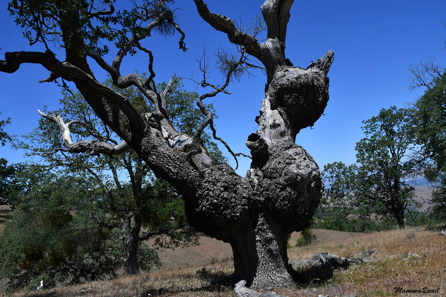
We started with ease, going downhill a very mild slope under the patched shade of a live oak forest. When we passed the tree in the photo below I was compelled to peek inside that hole. There were no surprises in there though.
 |
The Yawning Tree
|
A short distance downhill from Stewart's Camp was a small reservoir, still full. It looked like a nice spot the hang by but all we did was take a look and a few photos, then move on.
On the slope down to the reservoir was a nice patch of blooming lupines. I didn't get off the trail for a closer look but I enjoyed the color added to the dry grass.
Away from the reservoir the scenery was more like what we've seen earlier on the Ohlone Wilderness Trail: beautiful oak savannah of smooth, rolling hills.
Stewart's Camp is off the main Ohlone Wilderness trail, on a detour loop that adds more than two miles and one extra uphill section to this trek. I chose to add it because it passes close to Murietta Falls and, although I knew for sure that these seasonal falls would not be running, I still wished to see it.
We crossed the creek that was supposed to feed into the waterfall. The creek was dry, as I expected (can't deny that I did have a tiny hope that there would be water there). I couldn't see anything resembling a waterfall where the map marked it should be. None was visible from the trail.
Disappointed, we continued uphill some, when three young women came down the trail towards us. They too, were looking for the Murrieta waterfall.
From a higher place we had a better vision of the area and I saw a rocky place off the trail and figured that the waterfall must be there. We didn't get too far way from it so I wanted to go back and take a look. One of my companions decided to stay up and rest and the other joined me.
We left our heavy backpacks in care of our third companion, and galloped downhill toward the rocky place we saw from above.
A narrow path diverged from the main trail toward the rocks. we followed it to the edge and around a rocky protrusion and got a skewed view of a sheer drop smoothed by water.
The creek leading to the waterfall was really inconspicuous. No wonder I had missed it. We got around the rock protrusion and into the dry creek bed just above the waterfall.
From the top of the falls I could see how impressive the drop was and I wished I could see this waterfall in flow. I didn't dare getting all the way to the very edge so I don't have a photo of the full height of this waterfall. There was a thin trail leading to the base of the falls but we decided not to get down there.
 |
Murietta Falls, dry
|
A small cavity above the waterfall still held some water in it. The water was old, warm, scuzzy, and full of bugs.
Little plants grew in the cracks of the rock. It added a nice splash of color to the gray stone face.
Below the waterfall the creek continued on and on, eventually opening up into the Livermore valley. There's a trail there, and maybe another way to access the waterfalls, although on the map it looks much longer than the Ohlone Wilderness Trail from Del Valle.
We explored the Murietta Falls area for a few more minutes, then went back up the trail to where םur companion was waiting near the backpacks. She asked about the waterfall, we had a sip of water, and then we hoisted our backpacks and continued on.
We needed to reconnect with the Ohlone Wilderness Trail. It was an uphill stretch but not a very long one, and there were more mariposa lilies along the way.
 |
Yellow Mariposa Lily, Calochortus luteus
|
At the junction with the Ohlone Wilderness Trail there was a small cattle pond that perfectly reflected the blue skis and the surrounding oak trees. I felt compelled to check out that pond and this time my companions joined me on the short diversion to the water.
There were fish in that pond! Likely brought there to mitigate the mosquito larvae. They were not easy to see or photograph through the murky water.
There were patches of aquatic flowers on the surface of the pond. The first grabber of attention was the water lily, a non-native beauty. It's Latin name indicates it has a nice smell too but the flowers were too far from me to detect any fragrance.
 |
Water Lily, Nymphaea odorata, Non-native
|
On the muddy sides of the pond bloomed the much smaller but no less beautiful, water buttercup. It was much harder to get any decent photo of these little guys.
 |
White Water Buttercup, Ranunculus aquatilis
|
Blue butterflies swooped to the muddy pond sides, resting briefly, possibly sucking in moisture and minerals. I could watch them for a long time but we didn't have the time. After a few minutes of exploration, we got back on the rail and resumed our hike.
From the trail junction we had a fairly short uphill segment. When we reached the top we had the entire Livermore valley below, and Mount Diablo floating above it. Way down below we could see Lake Del Valle - our final destination.
 |
| Mount Diablo View |
We took a short break at the top, admiring the crooked trees and enjoying a snack. We talked a little about the incredible life story that one of my companions had shared with us yesterday. A few back and forth questions and answers had revealed that my other companion had quite an interesting tale to tell too.

We had a long way down. We were at the top of the longest and steepest slope of the Ohlone Wilderness Trail, the one that is called "The Big Burn". People who walk this trail from the east must climb it. We were going downhill.
 |
Indian Paintbruss, Castilleja affinis
|
Downhill is usually considered easier, or at least less physically demanding. Long and steep downhill slope are in fact, much more problematic in more than one way. I down think it's less physically demanding - the effort of stopping one self from sliding and slipping is very taxing. On top of that, it's the knee and hip joints that take the punishment rather than the muscles. To top it all, long and steep downhill slopes are where a hiker with less than ideal shoes is most prone to develop blisters.
My companion who had it hardest the first two days was now having the best time. Wearing sneakers rather than hiking boots, she had no blisters at all. She had also filled her socks with wads of petroleum jelly and was surprised that neither me nor our third companion knew about the effect of that jelly in preventing blisters.
 |
Coyote Mint, Monardella villosa
|
My other companion had arrived at the top of The Big Burn with some blisters already and as we were descending, they were causing her considerable pain. She walked very carefully, trying to place her feet down with as little roll as possible, and was moving very slowly because of that. She told us to go ahead and not wait for her but neither of us did. I too had some tender spots on my feet, foreshadowing the blister agony I'd have a month later coming down Mount Shasta.
All three of us stayed together. We walked slowly, me and my pained companion listening with much fascination to the life story of our third companion, who was now in a very cheerful mood and was able to distract our minds from the pain in the feet, at least somewhat.
 |
Chinese Houses, Collinsia heterophylla
|
The Big Burn is a north-facing slope, which made it the greenest and shadiest part of the entire Ohlone Wilderness Trail. It also had the biggest display and species diversity of wildflowers along that part of the trail.
 |
| White Globe Lily, Calochortus albus |
This time I didn't need to any excuses for walking slowly. Our progress was slow enough so I didn;t need more than a slight pause to get the photos I wanted.
 |
| Crimson Clumbine, Aquilegia formosa |
Down, down, down we went. It felt endless. We started slow and the further down we went the slower we got. It was good to have our unaffected companion tell her life story. It was so interesting that i was able to forget completely my discomforts. It was more challenging for our blistered companion but she too was able to engage in the conversation and didn't let much of her pain show.
At the bottom of The Big Burn was a creek and to my great delight it was flowing! We sat down to rest and filter drinking water. A California Sister butterfly flew by and sat on a nearby rock, undisturbed by my attention.
We took a long, restful break by the creek but then we needed to get up and move on. The next bit was an uphill again - a relief for the blistered feet. A dead sycamore holed by woodpecker marked the continuation of the trail after leaving the creekside.
The uphill part was all too short. South-facing, that slope didn't have too many wildflowers blooming by the trail, but there were some. Accustomed to the uphill walk by now, we climbed that segment in a short time.
 |
| Morning Glory, Calystegia malacophylla |
Once again we sat to rest. My companion who had it well today, and was sharing her own incredible story with us, persuaded the other one to smear petroleum jelly on her feet. She encouraged her to put lots and lots of it so it'll remain lubricated even after much is absorbed into the socks. I watched and retained the information in my memory for future use.
 |
Western Thistle, Cirsium occidentale
|
We were at the top of the last downhill lag, the one that would carry us all the way down to Lake Del Valle, where I parked Pappa Quail's car three days before. It was less high than The Big Burn, but it stretched along a longer distance. What was worse was that this part wasn't a solid earth switchback type of trail, but a gravel road, making it less stable under the feet. I had my poles to help with my balance but that terrain proved to be seriously damaging for my companion with the blisters. Her blisters were fully formed and bloated by now, beyond the aid of any amount of petroleum jelly, and she was suffering with every step.
There was no alternative but to go down. We walked slowly, taking frequent stops. Chatting and discussing common interests. I kept pointing out nature's curiosities to my companions, such as the mistletoe balls which decorated almost every tree along the way.
 |
| Mistletoe, Phoradendron leucarpum ssp. tomentosum |
Although we were going down a north-facing slope again, this one was more exposed and considerably drier than The Big Burn. Still, there were quite a few wildflowers to enjoy.
 |
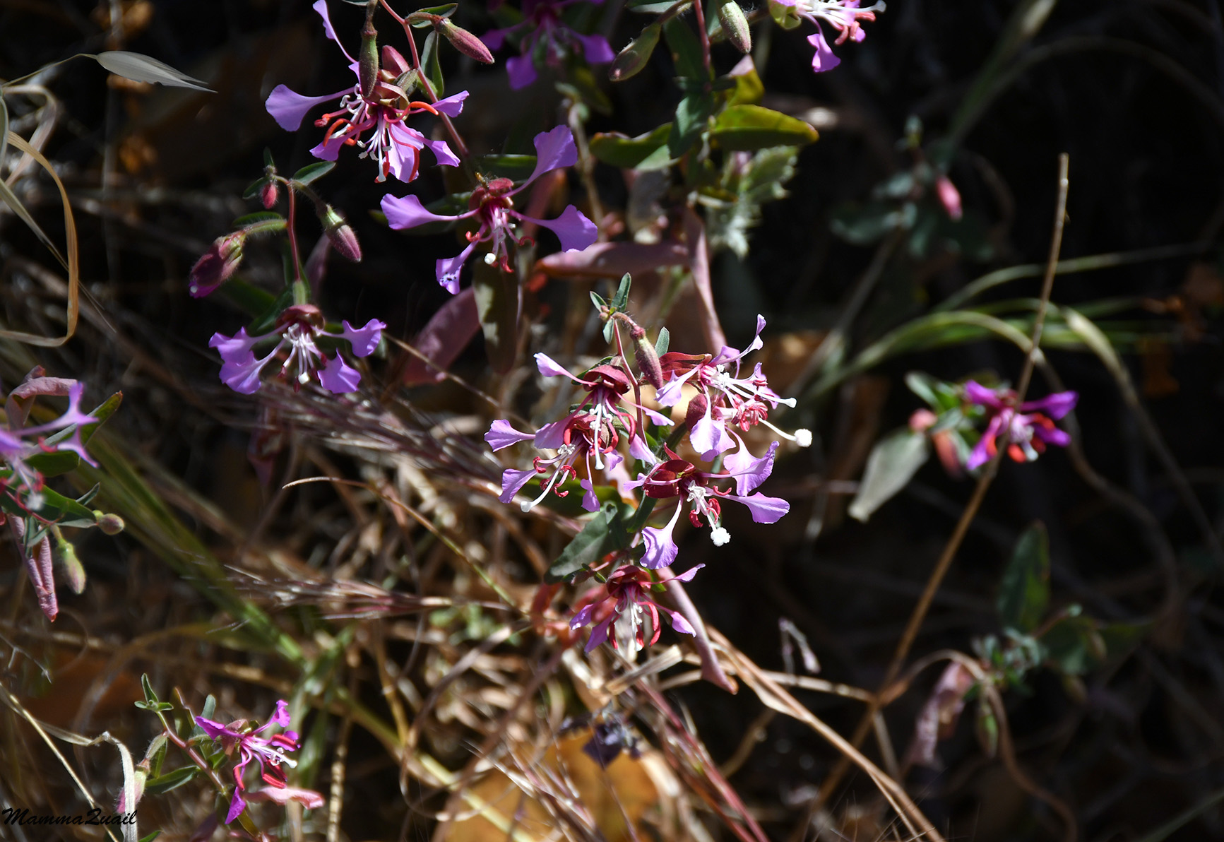
| Graceful Clarkia, Clarkia gracilis |
Mistletoe is a parasitic plant. Dispersed by means of birds poop, it sprouts on tree branches and digs into their vascular system for water and nutrition. It does photosynthesize, but relies mostly on its host's vitality. It's an evergreen too, and would be the only green thing on a wintering deciduous host, such as the Valley Oak. We were there in May so the trees were with full foliage, but it was still easy to tell where the host ended and the mistletoe begun.
 |
An oak tree (Velley Oak?) with mistletoe
|
There were many, many mariposa lilies along the trail. At some point I stopped taking their photos. There were just so many of them, both yellow and white, and each was perfect. This one however, had a butterfly inside it, so of course I had to stop and take a closer look.
 |
| Yellow Mariposa, Calochortus superbus |
We were descending continuously now. My hurting companion refused any more stops, arguing that stopping won't make the pain go away, and that she wanted to go on and finish the hike. Her words and demeanor were etched in my psyche. A month later I would say those very same words to the guide that stuck with me all
the agonizing way down Mount Shasta.
Unlike the forested slope of The Big Burn, this slope's greenery was nearly all high chaparral: a thicket of bushes, in this case quite tall. The few 'real' trees that grew on that slope were sticking out like the redwood Hyperion in the midst of normal trees. The tall pine in the photo below definitely was a giant among dwarfs, although it was probably an average size pine.
One of the most common chaparral bushes was the manzanita, with its shiny dark red and very smooth bark and coin-like gray-green leaves.
Turkey vultures circles the sky above us. I didn't take many bird photos on this trip, my camera isn't suitable for birding. This vulture however, was modeling nicely right overhead. Perhaps it was checking to see if we're dead yet.
 |
| Turkey Vulture |
May is the best time to see buckeye trees in bloom, and I was very excited to see a blooming one on the trail. It was sad to see that its leaves were already drying out however. We had practically no winter last year.
 |
California Buckeye, Aesculus californica
|
Further down the trail we got to a shadier area that was also greener, with lush coyote brush and poison oak, fully green still, decorated by the white puffballs of the pipestem seed heads.
 |
Clematis sp.
|
Another common chaparral member is the sticky monkeyflower. It too was at peak bloom, adding beautiful color to the dusty greenery of the slope.
 |
| Sticky Monkeyflower, Diplacus aurantiacus |
We slowly made our way around the final curves of the trail and the view of Lake Del Valle grew larger and larger. We were getting down later than I had expected but we were in no rush other than wanting to relieve the aching feet.
 |
| Del Valle Reservoir |
We reached the border of Del Valle Regional Park and signed out of the Ohlone Wilderness Trail at the signing board that was posted there. From there it was less than a mile to the parking lot. It was then, and only then that we encountered the first mosquitoes on this trip. The bug repellent that I packed was deep inside my backpack and I think it was the same with my companions. Instead of taking the backpacks off and searching for the bug spray we simply took off and started to (almost) run. All the aches and pains and discomforts were temporarily pushed aside - we were escaping an onslaught of mosquitoes!
 |
| Woodland Clarkia, Clarkia unguiculata |
Pappa Quail's car in the parking lot was a very welcomed sight. I reached the car first and dropped my backpack on the asphalt. My companions arrived on time as I pulled the key out and unlocked the car. Without delay we shoved our backpacks in the trunk, got inside and drove off, leaving the cloud of mosquitoes behind.
We had to go to Sunol first, to retrieve the car that we parked there on the first day of the trip. There we hugged and said goodbye to our companion with the blisters. She was very relieved to finally change her shoes. Then me and my other companion drove back to my home where she had parked her car. We stopped momentarily on the way to buy a watermelon and to text Pappa Quail that we're on our way.
I had a great time. I finally backpacked the Ohlone Wilderness Trail, and I felt that I was coming along well with my training for the Mount Shasta expedition that was coming up next month. It seemed that my companions also had a good time all and all, despite the lack of showers, the cold nights, and the blisters. The only thing that I was sorry for was not seeing Murietta Falls when flowing. That was corrected on a very strenuous day hike last Sunday, a hike I will write about separately.