Tuesday, January 29, 2013

An Unexpected Hike - the Quartz Vein Wash

Date: December 26, 2012
Place: Anza Borrego State Park, Borrego Springs, California
Coordinates: 33.13142, -116.30057
Difficulty: moderate

Not owning a hand-held navigator, I still find my way about using the old-fashioned method of consulting a paper map. In Anza Borrego State Park, one can acquire a 1:160900 map of the park with detailed roads, dirt roads, and more or less detailed foot trails. It isn't a topographic map though, a feature I missed greatly during our time there.

After finishing our hike in the Slot Canyon our next destination was to be the city of Brawley. I insisted on taking the long route there - via S-2 road and the town of Ocotillo and so to get a glimpse of the southern part of the park, which we didn't get a chance to explore on foot. We thought we had time for one short hike more in Anza Borroego before departing the park, and Papa Quail suggested the tiny Narrows Earth Trail loop that was marked on our map, just behind a bend on hwy78.
We estimated the stopping place as best as we could. When we exited the car we were welcomed by the wide and shallow mouth of a white-colored wash. Without much debate we started walking into the gaping wash.

Quartz Vein Wash
We didn't see any sign posts, but we did see plenty of vehicle tracks marking the white graveled wash bed. Expecting to hike a loop trail, we turned right into the first tributary we saw. It was barred to vehicles by a line of metal posts. We slipped easily between these posts and went into the tributary, expecting to pick up the hiking trail at any moment.
Acacia trees decorating the Quartz Vein Wash
One of the things that impressed me about Anza Borrego is how diverse the landscape is, even within a relatively confined area, and how each wash we hiked looks completely different and unique, like each having their own personality.
The Quartz Vein Wash certainly looked unique. It was so white that where it wasn't shaded, sunlight reflected off its pale walls almost as intensely as bouncing of snow. This whiteness comes from the quartz, which is the most abundant rock mineral in the Pinion Mountains, where the wash originates.
We hiked slowly up the wash. Looking for the path that will connect us back to the main wash we kept pulling towards our left.
A pretty rock garden
Agave pillar


Unlike the Palm Wash and The Slot, the Quartz Vein wash gets canyon-like only in short segments and even then its walls aren't very tall or particularly straight. But either gently sloping or sheer, they provide an excellent growth turf for many agave, cacti, creosote, and other desert vegetation. Always very artistically set.


At some point we realized that we have walked quite further than we were supposed to, even when allowing for the most permissive interpretation of the trail length, if to judge by our large-scale map. All that time we kept going up and up the side tributary, without seeing any signs of a hiking path or any place where we could easily have climbed over to the main wash. I kept expecting to eventually run into the watershed's boundary, but every time it looked as if we've reached the creek's origin, we'd turn the corner and there it would continue, on and on.

No end in sight.
At points, the wash would appear canyon-like.


What we did see, however, were droppings of Bighorn sheep that were relatively fresh. This sighting fueled our motivation and we kept on going up the wash, hoping to meet the elusive mammal that had left the incriminating evidence behind.


Although there was no 'real' hiking trail in this wash, for the most it was very convenient to walk. A bit of rock scrambling, but for the most it was walking in soft gravel, in a very gentle slope.
All and all, it felt as if we could continue at ease for a very long time. We couldn't, however, go on for much longer. Having planned on only a very short loop we didn't have enough water with us, and had no food at all. What we did have instead, were a pair of tired and whiny chikas, which at that point, had had enough of hiking for that day.  So I left Papa Quail and the chikas to rest for a few moments and went on by myself for a hundred yards more to a spot where I could take a photograph of the mountains from which the wash has originated.

Pinion Mountains
With the understanding that unintentionally we've made an intriguing discovery and the sadness that we did not have the time and were in no condition to explore it through and through, we turned around and backtracked our footsteps to the place where we left our car.
This was the last hike of our winter vacation in Anza Borrego State Park. They say that 2/3 of the Bighorn sheep population in California live within that park, but I didn't see any on them. They proved to be just like Yosemite's bears - everyone else sees them but me.

But we did see this golden eagle circling above our heads as we got back to the car :-)
Golden eagle
We got back into the car and started driving once more. About fifty yards round the bend we saw the post sign and parking bay for the trail we intended to hike originally. We shared a good laugh that lasted for sometime. By then, we were well on our way to Ocotillo and Brawley.

Thursday, January 24, 2013

Through Nature's Playground - The Slot Canyon

Date: December 26, 2012
Place: Anza Borrego State Park, Borrego Springs, California
Dirt road entry coordinates: 33.1591, -116.2188
Trailhead coordinates: 33.1907, -116.2231
Length: 2 miles
Difficulty: moderate

The badlands of Anza Borrego State Park are of sediment sandstone. Sand and small rocks that had eroded from the mountains were packed and hardened over the years to create the badlands material.  This semi-soft terrain is easily carved by flood water into spectacular canyons that provide fantastic hiking experience for adults and children alike.
Of the numerous canyons in Anza Borrego the most known one is the Slot Canyon and that's where the park's ranger had recommended we'd go. We went there with the friends we made at Palm Canyon and had a great time.
The upper, still shallow  part of the Slot Canyon
The way from the California hy 78 to the trailhead is 3 miles of a passable dirt road. The ranger had directed us to go to the end of that dirt road and go up the canyon. Instead, we parked in an area where we saw several other cars, and found ourselves near the upper part of the canyon.

There isn't an actual trail there, but what the ranger had called, 'a social trail' that's marked by the many feet that had passed there before us. The problem with that, of course, is that there's often more than one possible trail and, having to chose one of the few we saw caused us some confusion. Eventually we followed the most apparent path and entered the wash to our left, and started going down stream.
The deepening walls
At first, the wash was nothing but a shallow depression in the gravely ground. Before long, however, we dropped deeper into the earth. The softly packed gravel was replaced by hard-packed sandstone.
Layers of sandstone, lain by olden floods.
 The canyon walls, made of soft sandstone, are easily eroded by rain. Dried mud 'stalactites' decorate many areas of the canyon walls.
Dried mud dribbles.
We continued down the wash. At some point we could see far behind and above us the parking area. One last glance at our car and we plunged into The Slot.
The Slot


The canyon walls got really high indeed. Inside The Slot it got shady and cool. At some points it got very narrow too.
The Slot


Unlike Palm Wash, here we didn't need to do any rock scrambling. The wash bed kept being soft, flat gravel throughout, making it an easy walk. 


In some parts, large boulders that fell on top of the narrow canyon created a natural ceiling. 


Boulder ceiling


The Slot part of the canyon goes on for nearly half a mile before its walls widen enough to allow vehicles. We did see tracks of vehicular use there, up until the narrow part. 


On the other side of The Slot we encountered a flowering desert holly. It was a nice cheerful color to the otherwise brown-gray terrain.
Desert Holly (Atriplex hymenelytra)
On the other side of The Slot we saw red and green sediment layers. It made me wonder about the origin of the eroded soil that had made this canyon. I made a point to read about the region's geology by the next time I visit there.
Sediment layers
Eventually we saw a wide path leading uphill on the left side of the wash, where its sides were no longer sheer walls but manageable hills. We scrambled up and met the dirt road and an area where, I presume, we were supposed to park had we wanted to hike up The Slot.
The view from uphill included a Swiss cheese-like rock, similar to the one we saw at the Calcite Mines, but reddish in color.
Swiss-cheese rock
We hiked a bit down the dirt road. At some point the children sat down to rest. Me and one of our friends went on to get the cars and all of us had a nice picnic before separating and driving each family to its next destination.
The Slot Canyon is definitely a not-to-miss hike for anyone visiting Anza Borrego State Park.


And no, we did not see any Bighorn sheep there either.

Wednesday, January 16, 2013

Up the Calcite Mines and down the Palm Wash.

Because of a spammer robot that got hooked on this post I have taken it offline and now I am reposting it, hoping to shake that thing off.


Date: December 25, 2012
Place: The Calcite Mines Trail, Anza Borrego State Park, Borrego Springs, California.
Trailhead coordinates:  33.2811, -116.0964
Length: 3.6 miles
Difficulty: strenuous

After completing the Cactus Loop trail we stopped for a breakfast picnic at the park's visitor center, and got trail recommendations from the ranger on duty. Following the recommendation, we went to the Calcite Mines, in the north-east region of the park.


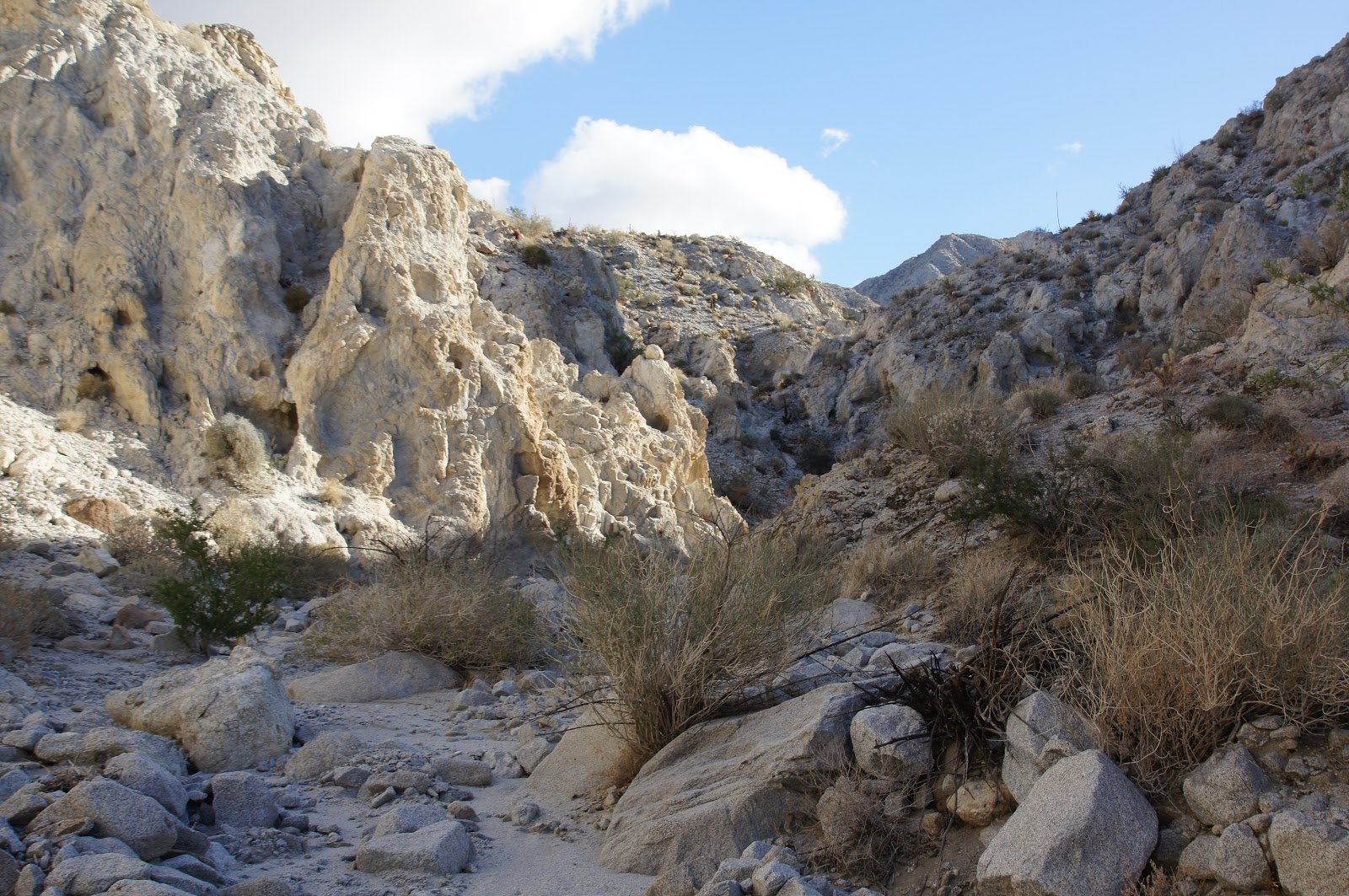
The calcite mines trail in the badlands at the north-east region of the park. There is a dirt road that leads all the way up hill to the mines but it is in very bad condition and would be challenging even for a high 4X4. We parked by the trailhead and hiked all the way up.

Sandstone formation
Badlands, in Anza Borrego as in other places so named, is an area of sediment soil and rocks that have eroded from the mountains. The entire area is carved by wind and flood water. Canyons and gullies run deeply across the land, making it difficult to traverse.
It is also very beautiful. Badlands - maybe for farmers. But for hikers and wilderness lovers it is a shrine of nature. A place where its raw power is lain naked before the eyes.


The trail starts by crossing the Palm Wash northward. On the roadside there were many sandstone formations such as the one to the right. I can imagine it was formed by eddies of long ago floods but I cannot tell what caused these to be exposed in this manner.


Palm Wash, the south fork.
Going up the dirt road gave me some great views of the deep ravine of the middle fork of Palm Wash. At the time I took these photos I did not know I will soon be going down through that very same rock slot. 

Palm Wash, the middle fork.
I didn't see much vegetation on the way to the mines. The intense radiation and the quick water runoff could be very limiting indeed. The shrubs I did encounter were well rooted inside rock cracks.


We saw interesting rock formations all along the trail. Some were very intriguing indeed.

The two-headed sentinel, a view from below


I liked this one so much that I photographed it from the trail below and also from the several view points.


The two-headed sentinel, a view from behind


I even gave it a name - the two-headed sentinel.


The two-headed sentinel, a view from above.


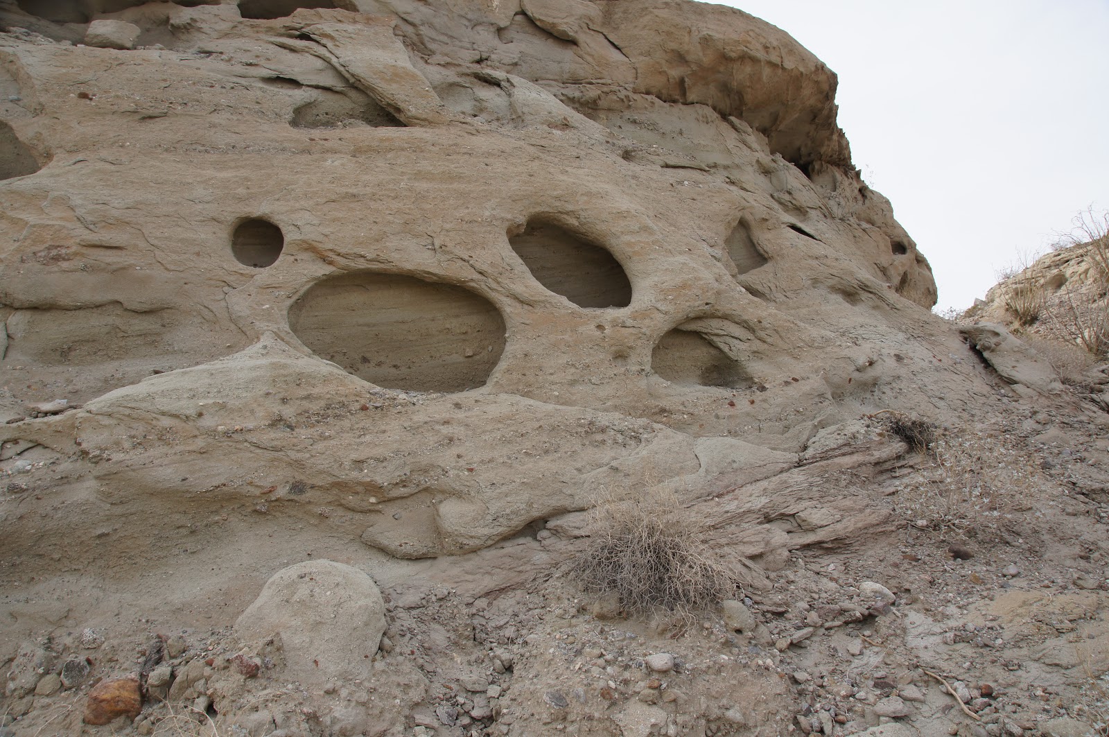
Early on the hike we saw a large rock far up the trail that looked like a huge chunk of pale swiss cheese.


The Calcite Mines trail goes up constantly with no let-up. At some point, quite high up, it crosses the middle fork of Palm Wash. A look upstream revealed some green bushes, hidden inside the wash where they are protected from winds and can rely on extra water during floods.

Wash shrubbery. 
At that point the chikas insisted on having a rest stop. Papa Quail sat with them while I went on to scout ahead.
The swiss-cheese rock
This rock is, in fact, right in the calcite mines area. We got really close to it but didn't climb there. I could, however, get a good close up view of its holes.


I called the chikas and their father and they joined me in appreciation of this geological wonder.


After the attach on Pearl Harbor, calcite was mined in this area to make gun sights. The trail we were walking on was once the road that serviced the mines.
At first we thought that these holes in the rock were man-made: the scars of mining. Thinking about it more, I now believe these are natural. Human mining is considerably more abrasive.

Some carvings, right by the trail, did appear to have been made by chisels. They reminded me of old runes or petroglyphs.


The trail ends at the Calcite Mines sign. A short distance to the south-east rises a reddish butte that  provides an excellent view of the entire area. A narrow foot trail leads to the top so naturally, we all ascended it.


The view from up there was spectacular.

To the east - the Salton Sea.
Salton Sea
To the south - the entire badlands spread before us.

The badlands of Anza Borrego State Park
To the west - the San Ysidro Mountains. In the overcast lighting they reminded me a bit of Mordor.


The most common plant up there is the Creosote, or 'stink' bush. I didn't think it smelled that bad. It grows all over the park, but it was in the Calcite Mines area that we first saw its flowers:

Creosote flowers


Many of the Creosote bushes bore brown ball-shaped galls, induced by the Creosote gall-midge fly.
Creosote gall


Upon descending from the red butte Papa Quail suggested that we return via the canyon. There were two factors to consider. One being that we didn't know whether the canyon is passable, and the other being that the canyon continued eastward towards Salton Sea, crossing the road some distance east to the trailhead where we've parked our car. 
We figured that we had enough time to backtrack in case we run into a problem. Looking down the canton with the binoculars we could see a trail climbing on the hillside to the east and thought it might connect us back to the Calcite Mines trail. So when we reached again the place where the trail crosses the middle fork of Palm Wash, we left the trail and headed into the wash.

Pigmy-cedar bush growing from a crack in the canyon wall.
The upper part of the wash is fairly wide and shallow, and easily traversed. That soon changed. Before long we dropped into a deep, narrow canyon.
Narrow canyon walls
I'd like to pause here for one very important warning for anyone who considers entering such a canyon - keep in mind that once inside, one must go through all the way. There is no other way out. Not unless you're an expert rock climber who can climb sheer rock without equipment.
Most of the year that would not be a problem. In winter time, however, it is crucially important to heed any warnings of flash floods for the area. It doesn't have to rain directly where you're hiking. Any rainfall within that watershed can create a flash flood, and desert watersheds can be very large.
It is not a common event but it does happen often enough. The flash flood is very sudden and very powerful. For anyone caught withing such a canyon, it is deadly!
This isn't an idle warning copied from some desert hiking instruction book. Growing up in the desert myself I have seen plenty of such floods and had the sad experience of witnessing casualties of such a flood in the wash near my childhood home. Please don't take lightly any warning of flash floods.

Okey. Now that that's been said, I can also tell you that hiking through such a canyon is a lot of fun!  It involves a lot of squeezing, climbing, rock scrambling, sliding down rock chutes and such. No theme park can match the unpredictability and uniqueness of Nature's playground. Needless to say, the chikas (as their parents) had a great time!
Boldly going where flash floods have gone before
In some sections, the canyon got so narrow that Winnie the Pooh would never have gone through after a honey feast at Rabbit's. We did ok, though. We had to help the little chika down some of the chutes, but my older one climbed them like a true Bighorn sheep.

Desert trumpet (Eriogonum inflatum)

Being the place where the precious rain water collects, the canyon bed can support more plants than the surrounding area. Quite a few of them were, in fact, blooming at the time.


Pigmy-cedar (Peucephyllum schottii)


Desert lavender
I didn't recognize this one


Inside the canyon we also saw interesting rocks. This boulder fell sometime ago from the canyon wall and split along the layers. It reminded me a bit of a smashed piece of layer cake.

This one looks like someone's hand print. It is called desert varnish and is similar to the red coloring of the observation hill above the calcite mines.
Desert varnish on a rock
Eventually the canyon grew wider. We could even see tire tracks on its gravel bed, indicative of vehicular use. Then we saw the trail that goes uphill to the west and ascended it. Sure enough - we were right back on the Calcite Mines trail, a short distance from the trailhead. We have successfully competed the loop.
The view into the canyon from the top of the exit trail.
I took one last farewell photo of the Palm Wash canyon, going on towards the Salton Sea. I really love the colors of the desert rocks there.
All and all, the entire hike took us about 3.5 hours. We saw interesting geology, wonderful views and many plants.The only wild animals we encountered were ants. No Bighorn sheep there.
Palm Wash
That night we camped in the park next to our new friends that we made at the Borrego Palm Canyon. The sunset was very pretty indeed:
Sunset in Anza Borrego
And the full moon that followed was no less enchanting. I really do love the desert.