Saturday, August 25, 2012

Redwoods In the Rain: A Wet Hiking at Limekiln State Park.


 Place: Limekiln State Park at Big Sur, California
Coordinates: 36.0085, -121.5181
Date: November 24, 2012
Difficulty: easy.

On 2011 Thanksgiving break we planned to visit the coastal redwoods up north at Redwood National Park but the weather forecast made us change direction, so we traveled south to sunny Santa Barbara. On our way we did a lot of sightseeing as well as some hiking. We spent half a day hiking all of the two-miles trail system of Limekiln State Park in a nearly constant drizzle and had a great time. 
Limekiln State Park is in the south region of the Big Sur - that mountainous landmass looming between Monterey and San Simeon. The Big Sur slopes steeply into the Pacific Ocean, creating the owe-inspiring coastline of the famous highway 1 scenic route. 
Most of the Big Sur is part of the Los Padres National forest. There are, however, several state parks in that region along highway 1. Linekiln State Park is near the south part of the Big Sur, close to San Simeon. It is a small park with only three trails, all of then easy and all of them combined are just under two miles.

It was overcast and drizzling when we arrived but we were already tired of sitting in the car so we went hiking despite the rain. Naturally, I kept my camera hidden under my poncho most of the time. I did, however, use it often, so do forgive the droplet spots that appear on some of the photos.
My first and strongest impression of the place was: 
Red!  Green!

Redwood trunks and red-littered forest floor.
A lush redwood forest is exactly that: the bottom forest floor red with fallen redwood foliage and thick red trunks supporting a distant canopy. In contrast, the hill slopes are green with mosses, ferns and other small vegetation. 
Dark forest floor carpeted with red fallen redwood leaves
We didn't expect to see any wildflowers in November, we did see a different type of bloom - fungi.

Mushrooms are the fruiting bodies of fungi: organisms that exist as filaments underground and within rotting vegetation and live of the dead organic material.

Fungi make a crucial link in the forest life cycle. They are essential to the process of disintegrating dead wood and other organic matter and releasing the nutrients back into the soil, thus making them once more available for living plants.
 There are so many kinds of fungi, and all of them are beautiful. The wet season is, of course, the best time to see them. That is when they form the above-ground fruiting bodies and release their spores.
 Our older chica is fascinated with mushrooms. She insists on us photographing each and every one we encounter on our hikes. After this particular hike we got her a camera of her own :-)
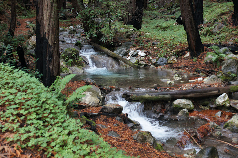
The main trail leads directly to the lime kilns - the historical part of this park. We, however, first took the second branching trail southward towards the falls. The creeks were all flowing strongly, and we had to ford the water more than once, often wetting our feet.


The trail was crawling with bright yellow stripes - banana Slugs - the only animals we've encountered the entire hike. We had to take great care not to step on any.
Banana slug
Banana slugs are quite large - we've seen some as long as an adult hand. They need the wet conditions to move around, eat and mate. They are common throughout California, but in many places they are already mixed with the invasive gray European slug. It was nice to see the bright colors of this California native.

Cute, isn't it?
We encountered many fallen trees across our path and we had to climb over or crawl under them.


Most of the time it felt like walking an obstacle course but some time the fallen logs came in handy when we needed to cross the creek.


My impression was that the trail was not being maintained. Not well, anyway. This has added some interesting challenges to our hike but also gave the entire area a more wild appearance, and a great deal of excitement for the chicas.


The trail leading to the falls is only 0.2 mile long, but the obstacles slowed us down considerably. Eventually, we did reach our desired destination:

Limekiln falls


There wasn't much room to stand near the falls and we crossed the creek once more to reach a small graveled area where we could sit and eat our snacks, and enjoy the view and the misty spray of the falls.


After we took our rest we backtracked to the main trail, which was much better kept and continued east to the kilns. There were more redwoods along the main creek. The little chica enjoyed sneaking into the hollow ones:


The big trunk's bottoms painted green with lichen and moss:


We also seen the evidence of a past fires:


And eventually we did see a real flower! 

Redwood Sorrel
The main trail leads to the lime kilns that give the park its name. These kilns are the only remains of a short-lived lime mining industry that operated there from 1887 to 1890. Excavated limestone was fired in these kilns to purify the lime. 
The lime kilns
Naturally, the wood used to fire these kilns was logged right there. Fortunately for the redwoods, the limestone bed was quickly exhausted and the mine abandoned.


I can testify that the forest has recovered nicely since :-)

The limekilns trail does not loop so we headed back the same way, enjoying the water flow in the creek. It is amazing how the wetness brings out the forest colors in the strongest.


Upon returning to the first branching trail the chicas were already tired so I left them with Papa quail to continue to the parking lot and I went to explore that side trail by myself.

A fallen tree cascade
There weren't any new sights along this trail. Creek, woods, water. Pretty. Very pretty. Actually, let me take it back - I saw this pretty emerald pool:

I might have appreciated this trail more if I wasn't conscious of my waiting family. The trail dead-ended in a pile of fallen logs and forest litter and I turned around and hurried back.
By that time the rain has intensified. We had a quick, wet lunch and returned to the car. Limekiln State Park also features a beach and a campground but we have decided to save those for a drier visit.
We enjoyed the hike very much. Rain or shine, this beautiful park is definitely on our 'visit again' list! 


Friday, August 17, 2012

A Little Volcano in a Big Desert: Ubehebe Crater.

Place: Ubehebe crater, Death Valley National Park, California
Coordinates: 37.01420, -117.45356
Date: October 12, 2011
Level: easy. 

Death Valley National Park is one of my favorite places in California and if it hadn't been a full day's drive away from my home, I'd probably visit it more often. Ubehebe crater is located at the north region of the park, a bit removed from the more visited parts of Death Valley. I don't know how many people would drive all day just to see Ubehebe, but if you do travel to Death Valley National Park, it is definitely worth visiting. I have visited Death Valley National Park three times already, and Ubehebe twice. The photos presented here are from our latest visit, in October 2011.
Ubehebe is a large crater in a volcanic field. Its age is unknown but estimated to be no older than 8000 years. There are several adjacent, smaller craters, but Ubehebe is the largest of them, about half a mile in diameter.
There is a 2-miles loop trail that goes all around the crater's rim, with and option to go down to the bottom of the crater. 

Ubehebe - an almost full view
Despite the barren appearance, the area does get some precipitation. Little salt flats are what left when collected water evaporate.

A small salt flat on the slope of Ubehebe
Desert weathering creates a jarred-looking scenery. The big crack on the valley floor is a deep wash. Normally it is dry, but when rain comes it can flash-flood. 
I just love to see the colorful rocks and the light-shadow patterns of the cracked landscape.
A dry wash jarring the arid valley floor.
The top part of the crater wall, beautifully patterned with little run-offs, like an artistic knit-work hem.
A close-up of the crater wall.
Ubehebe is deep in the desert and we visited there in October, after a long summer and before the rains. We didn't expect to see much greenery there, and sure enough, there wasn't a lot. But there was some.

A brave desert survivor.


The dark soil was dotted with small, leathery leaf rosettes.The reddish-pink color is that of carotenoids and flavanoids that protect the plants from excess radiation. Naturally, desert plants would have more of these pigments. Enough to override the chlorophyll's green.


Hairy leaves

These leaves are also pretty hairy. The white hair cover serves to reflect back excess sunlight and also to limit transpiration and conserve the plant's precious water.
It being October, we didn't expect to see any flowers, but we did! Here is a pretty composite bush - a velvet turtleback. It is small and its flowers are tiny. Still, it added a jolly splash of color to the dark volcanic soil.

Velvet turtleback (Psathyrotes ramosissima)

As did this pretty pink: 

Bigelow's monkeyflower (Mimulus bigelovi)

Animals are found there year-round but what we've seen mostly were shy lizards, too quick to photograph. We were lucky to come across a red-tail hawk lurking in the bushes. This is the darkest form of this species that I've seen. 


Soon enough it got tired of our attention and took off. 
Taking flight
There are several craters in the area of Ubehebe. Here is a smaller one.

One of Ubehebe's neighbors
The walk was easy. There are no major height changes on this trail and the circular path allows a wonderful view of every corner of the crater. There is a trail that leads inside but the chicas were already tired so we didn't get to the bottom of it.
If, no. When you go there - make sure to bring lots of water and sun protection.  I will also add that although our visit was in mid-October, it was still (not very surprising) very hot. The best time to visit Death Valley is in late February - early March, when the temperatures are more welcoming and, if it is a rainy year, the desert will be carpeted with wildflowers.
So don't forget your camera! 


Monday, August 13, 2012

An Underground Anecdote: the Subway Cave

Place: Subway Cave, Old Station, California
Date: 10/17/2011
Cave at 40.680876, -121.424136. 
Length: about 0.5 mile in and out
Level: easy (requires flashlights). 

We've had frequent visits to Lassen Volcanic National Park but only recently became aware of the Subway Cave - an ancient lava tube just a quarter mile north of the 89/44 junction in the town of Old Station, less that 15 miles north of the entrance to Lassen Volcanic National Park.


If you are in the area, particularly if you have children with you, make sure to visit this place. It is very cool :-) 

Venturing into the darkness. 
This cave is part of the Lassen National forest, which offers guided tours there on summer weekends. On our first time there, we joined this tour and enjoyed it much. The ranger had extra torches (we brought our own next time around) and pointed out to us the earthquake cracks in the cave wall, a lava bubble that solidified upon popping, plant roots emerging through the cave ceiling and talked about the area's geological features. 

This cave was formed during an eruption 20000 years ago, when the edges of a lava flow crusted and solidified, while inside the lava remained hot and fluid. When the inside flow emptied out, the cave walls remained. 
This cave is wide and fairly tall. There is only one spot were we needed to stoop a bit, but most of the time we could walk erect with ease. Also, the bottom reasonably even, without any surprise holes or drops. 
Because it is underground the cave is fairly cool too. A very refreshing coolness on a hot summer day. However, it is not a bad idea to bring a sweater or a shawl. 
Waiting for the subway to arrive. 
This cave is pretty long but only part of it, about 1/3 mile, is open to the public. Because there are no ceiling holes or vents, it is very dark throughout, so be sure to bring flashlights.

A single ray of light piercing darkness.
There is an exit on the other side and one can chose to either go back through the cave or along the above-ground trail (from which, sadly, I have no photos. Nice shrubbery, though.)
All and all, it is a wonderful 30-45 minutes stop, and the children absolutely love it!

Credit where credit is due: the photos in this post were taken by our friends who joined us on this trip. 


A Beautifully Disturbed Land: Cinder Cone, at Lassen Volcanic National Park


Place: Cinder cone, Lassen Volcanic National Park
Time: almost every year since 2000 :-)
Trailhead at 40.5687, -121.2977
Length: about 4 miles
Level: Moderate to base of Cinder cone. Strenuous including the climb.

The photos in this post were taken during several trips there and, therefore, they show different seasons and lighting patterns. 

Lassen Volcanic National Park is one of our hottest places for camping and on-foot exploration. We also love to show off this part of beautiful California to our numerous visitors from across the continent and from overseas. We hiked many regions of this park and are never tired going back there, again and again. One of the hottest spots for us in this park is Cinder Cone, located near Butte Lake, in the north-east part of the park.

Butte Lake, view to the east. Photo taken by a friend who was hiking with us.
The trailhead is near the boat launch of Butte lake, in the day use area of the Butte Lake campground. Getting there is by a 6-mile long dirt road (forest route 32N21) turning south from hy44, outside of the park.

Fall colors along route 32N21. Photo taken by a friend who was hiking with us.
The trail stretches southwest with an easy ascend, beginning alongside the Fantastic Lava Beds, then diverging into the woods. It is easy two miles to Cinder Cone, walking on soft, sandy cinders between neatly spread out Ponderosa pines.


An easy walk. And then the trees open up to reveal ...
"Are we going to climb that???" were the words of my father-in-law on our first visit to Cinder Cone.

Standing 750' tall over its surroundings - Cinder Cone. 
This is the most perfect cinder cone in California. It is thought to be the product of two successive eruptions during 1650. This lava vent spewed enormous amounts of lava, causing devastation in an area that stretches between Butte lake in the north and Snag lake in the south. This area, now named the Fantastic Lava Beds, can be seen in all of its majestic beauty in this satellite photo I took from Wikipedia:

Cinder Cone and its lava beds as seen from space. Photo taken from Wikipedia
Yes, we did climb it. Back then in 2001 and four more times since, the last one in October 2011. The steep slope and the soft cinders gravel make the ascend a really gruelling one. It is so strenuous that it is truly surprising to find out that all in all, it takes just about 45 minutes to get up there. In fact, both our quail chikas have made their first way up on their own two feet at age five. It does help to have older friends along, though, for the moral support :-)

Cinder Cone trail. Photo taken by a friend who was hiking with us.
Making the slow turn around Cinder Cone during the ascend reveals the snowy Lassen Peak to the east.

Lassen Peak, 10462 ft tall. Last eruption: 1917.
The first thing I do after finally getting up there is to sit and recover. Then it is time to look around. The view is absolutely stunning. Looking south-east one can see all the way to Snag Lake and the peaks beyond. Just before Snag Lake there spreads the devastation area, covered with the crusted Fantastic Lava beds. It is interesting that even though the eruption happened nearly 400 years ago and that volcanic soil is a very fertile one, there is almost no vegetation growing on those lava beds. The reason is, of course the harsh weather conditions in this area, which slow down forest recovery to a crawl.


At the foot of Cinder Cone there are The Painted Dunes: low hills of fine cinders spotted with circles of mineral-containing soil. The dunes are dotted with pine trees that look almost bonsai-size from above. This is the place to mention that although very tempting, it is absolutely forbidden to leave the trail and go climb these dunes. With the extremely slow weathering happening in this area, every foot print or tire mark remains there for a very long time indeed. Lesson learned the hard way: on the dune face near the trail there are tire marks over 30 years old, like a mark of Cain.


The devastation area stretching all the way to Butte Lake to the north-east.
North-eastern view from Cinder Cone.
After looking at the view I take a closer look at the rim. Cinder Cone has a double rim and a simple crater (and not a caldera, as I previously thought, because it was created by a simple eruption).

The double-rim crater of Cinder Cone.
There are some pine trees growing on the rim, small and stunted as bonsai.

A small pine tree on top of Cinder Cone.
There's some other vegetation there, sparse and small.

Fall colors on top of Cinder Cone. Photo taken by a friend who was hiking with us.
On my first trip up there at 2001, and also on the last one ten years later, I found the energies to go down the little trail that leads into the crater. There, at the silent maw of the volcano, there is a pile of rocks. I laid on my back and looked up at the circle of blue skies surrounded by the crater walls and thought about Jules Verne :-)
The crater of Cinder Cone. Photo taken by a friend who was hiking with us.
There's no need to take the same trail down because there's a second trail on the southern side of Cinder Cone. Last October we took the southern trail down and circumvented Cinder Cone to its north on our way back to Butte Lake (which does, by the way, provide nice swimming on a hot summer day).
West Cinder cone trail. Photo taken by a friend who was hiking with us.
This hike is about 4.5 miles long, and the only strenuous part about it is ascending Cinder Cone itself. The entire hike took us (with young children and lots of time taken to appreciate the view) about six hours (not including the drive there). I've hiked Cinder Cone five times now, and I'd just as readily do it again. It's worth every drop of sweat, trust me.