
 |
| Human Stupidity Has No Limits, 1997 |
Date: December 18 2023
Place: Surprise Canyon Wilderness, Inyo County
Coordinates: 36.112598, -117.175423
Length: 3.5 miles
Level: extreme
Seven years ago I went on a fantastic road trip with a childhood friend of mine in the deserts of California. One of the hikes we did was up Surprise Canyon in the Panamint Range. It was a strenuous and very exciting hike, and although we toyed with the idea of backpacking up to the ghost town of Panamint City we were not prepared for it, so we settled for a day hike up and down the running water part of the canyon. Ever since that hike I kept the desire to go back there again, and to climb up all the way to Panamint City. When the opportunity presented itself recently, I immediately grabbed it and started planning this trip. I invited a friend (who allowed me to refer to him as A.S. here), who has been wanting for a while to go on a backpacking trip to join me, and he accepted my invitation. When the day came we left the Bay Area early in the morning and drove a full day to Panamint Valley.
The dirt road to Chris Wicht Camp Parking (used to be Novak Camp last time I was there) has deteriorated considerably since the last time I was there. It takes a high clearance 4WD to get all the way to the trailhead now. Good for us, I have such a vehicle.
 |
| At Chris Wicht Camp Parking |
We camped at the Chris Wicht Camp on the night of December 17. We passed a nice evening by the campfire, chatting and discussing our upcoming adventure. A.S. had done some reading about the place, I had my memories from my previous hike here. Just before darkness fell I noticed a low plant blooming near our campsite. It was too dark to photograph it then, but I did remember taking some photos of this plant in the morning before we set out on our hike up Surprise Canyon.
As we were packing up and getting ready for the hike we saw three young men striding up from below toward the trailhead. I don't know where they had parked but they seemed very surprised that we drove a car up to Chris Wicht Camp. We wished each other a good hike and they swooped speedily by us and disappeared up the trail. I sighed. I hoped to have the canyon all to ourselves.
 |
| Silky Dalea, Dalea mollissima |
My backpack was quite heavy. Unusually, it wasn't the water that weight me down, but the winter gear. My plan was to get to Panamint City on the first day and set camp there for two nights, and the forecast was of very cold, sub freezing temperatures, and possible snow on the second night. I therefore packed a heavy duty sleeping bag and an insulating sleeping pad, both heavier than those I take on my summer trips. I also packed heavier clothing, including a warm hat and a pair of gloves. Fearing an icy trail I packed shoe chains as well. We also included muck boots for the wading part of the hike, which turned out to be much longer than I expected. All and all, on the morning we set out on the trail, when I heaved my backpack on my shoulders I thought this was the heaviest pack I ever carried on a backpacking trip. (In hind sight, I do think that the pack I took up Mount Whitney on the summit day was heavier, but that's because I was carrying a lot of water, a weight which does diminish throughout the day).
 |
| Our Day 1 Hike as Captured by my GPS |
At the canyon mouth stand the old remains of a mining structure that was operated at the Chris Wicht Camp. The structure was ruined by floods but the remains still dominate the view of the canyon from the trailhead. It is on the north side of the creek though, and the trail starts on the south side, so we merely looked at the structure but didn't visit it. Not that day, anyway.

I signed us at the trailhead log box and realized that the trio ahead of us were going only for a day hike. They'll return down today and we'll be there on our own for the rest of the trip. We started walking up the trail, and right on the beginning I saw some flowering plants, one being a familiar California desert plant - the brittlebush.
 |
| Brittlebush, Encelia farinosa |
Next I noticed the apricot mallow. I was familiar with this pretty desert plant from other hikes in the California deserts and I love the intense color of its flowers. I was surprised however, to see it, and other plants, blooming in mid-December. Then I remembered the hurricane that swept through southern California last August. The accompanying downpour explains the uncommon winter bloom in the desert.
 |
| Apricot Mallow, Sphaeralcea ambigua |
The trail started ascending the canyon side, which at the lower side was made of packed gravel. After a short ascent we run into a dead end and had to walk back down. Two steps down I slid and fell down, scraping my hand, which started bleeding. I decided that the scrape was minor enough, got back on my feet, and continued walking.
 |
| Cress |
Surprise Canyon is a rare gem indeed and well worth its name - it has a short year-round running creek that originates in springs up the mountain and disappears underground, before reaching Panamint Valley. This flow of water is singular indeed in a vast desert that is mostly devoid of ant surface water, and is only seen by those who venture into the canyon. After the 2023 August hurricane the flow of Surprise Creek was particularly high and long. The creek was considerably higher than what I remembered from January 2016. We hardly got any distance into the trail when we had to switch to our muck boots because there was no avoiding wading in the water.

The flowers were pretty but the dominant vegetation colors were those of fall. All the riparian trees and large bushes were changing their leaves and the fall colors effect was stunning. It looked in places like a line of gold running through the canyon.

Very different plant community was growing on the canyon walls, only a short distance away from the water. Naturally, there were fewer plants. Of these plants the dominant was the California barrel cactus.
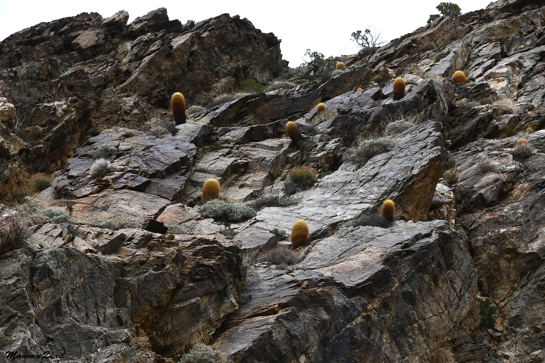
None of the barrel cacti were blooming, nor did I expect to see any of them bloom. The cacti however, were too affected by the August rain - they all looked very healthy and plump.
 |
| California Barrel Cactua, Ferocactus cylindraceus |
Between the rocky canyon walls and the creek was an intermittent strip of gravel ground. There were plants growing there too, and some were also blooming.
 |
| Desert Trumpet, Eriogonum inflatum |
As I said earlier, very early on we had to start wading in the flowing creek. Besides the higher flow level, another very big change since my last hike here was that the trail was not obvious at all. There was no one clear trail to walk on, but numerous paths trampled through the vegetation.
 |
| Surprise Creek |
Moving through the creek was very slow, because it took time to figure out the path of least resistance, and managing the resistance that we met even in these paths. The slow movement allowed me also to notice more details in our surroundings. Whenever I raised my eyes from the terrain we walked on I would look at the slopes looming over the canyon. Ahead, just before the next curve of the canyon I saw a dark, vertical line running down the canyon wall. I pointed it out to A.S..

It took some more struggle up the creek to get closer to that dark rock line. This was a dike - an igneous rock that rose as magma through a crack in the existing rock and solidified there.
 |
| Dike |
The canyon narrowed. This made the pathfinding much easier - there were much fewer options in the narrow width of the canyon. On the other hand, the water wading was almost a must throughout this entire section of the hike.

The vegetation we were walking through became a bit easier to negotiate too. It comprised mainly of horsetails. The few willows and other trees that we did encounter were actually useful as handholds and support islands.

We were rising up the canyon. Most of the uphill was not too difficult, but then there were also the cascades and the waterfalls. There are three distinct waterfalls in Surprise Canyon and a number of cascade streaks in between.

The lower waterfall is relatively small and we were able to bypass it and ascend through the vegetation on the side.

The vegetation in the 'splash zone' of the waterfall was very lush and very sleek. I felt very sorry for any trampling that we did, trying to minimize the damage as much as I could. The easiest way was to walk in the footsteps of people who walked through ahead of us.

We reached the middle waterfall shortly after we walked around the lower one. The middle waterfall was wide, from the south canyon wall to the north. There was no bypassing the water on this one. There was also a pool at the bottom of the waterfall. We poked at the pool with our hiking poles, trying to assess how deep it was. There was a good chance the the muck boots would not be enough to keep our feet dry. I was worried that the rocks would be too sleek and risky to ascend.

After a few minutes of looking and assessing, A.S. took the lead and pointed out what looked like the optimal route up the waterfall. I was glad to have him try it first - I didn't trust my balance very much. When he made it up the waterfall safely and reasonably dry I followed suit. I waded carefully through the bottom pool on the south side and pondered the bit of wisdom that was etched in the rock, saying: Human Stupidity has no limits". This writing was dated to 1997. I noticed it on my previous hike in 2016. It seemed a little harder to read now.

I too made it safely up the middle waterfall. There were more cascades higher up the canyon and we walked up them slowly and carefully.

The next cascade section was in a much narrower part of the canyon. We were able to walk up it mostly dry by climbing the rocks on the side, and switching back and forth between the south and north sides.

Above the higher cascades section the canyon widened and we found ourselves once again struggling with the vegetation, and with figuring out which was the best path to walk on.

As soon as we got out of the vegetation snag we came upon the next series of cascades, which we had to ascend through the water again. It was beautiful and not very hard, but it was tiring. It was time for lunch, but we were not yet in any place suitable for taking a break.

At the top of the cascades we saw a very strong and beautiful colorful growth of, I'm not sure if bacteria or algae. We avoided stepping on it, it looked very sleek.
 |
| Microorganism color mat |
We were getting pretty tired and there was one more waterfall, one which I didn't remember existed, coming up. The three hikers that started up before us were now coming down and they told us that the trail becomes easier once we ascended that third, higher waterfall. That was a big fat lie but they didn't know it because they didn't continue much further above that waterfall. Anyway, we decided to have our lunch break on top of the higher waterfall.

The third waterfall cut through a very narrow part of the canyon and it wasn't really visible from the bottom because it was all plugged with thick riparian vegetation.

We found a reasonably dry path to ascend on on the north side of the waterfall. When we reached the top we slumped on the rocky ledge there and dropped our backpacks down. I was too hungry and tired and I forgot to take a photo of the top of the waterfall. I did so on our way back, two days later, though. We ate, filled our water bottles, and rested for a good while before we were ready to get going again.

There used to be a road that went all the way up Surprise canyon from Panamint Valley to Panamint City. That road no longer exists - Nature had claimed back her canyon since, but evidence of human vehicular travel were present in various places throughout the canyon. One of these, an old pickup truck, is fairly close to the top of the higher waterfall.

For a short distance it seemed as if the hiker trio we've met were right - the trail did seem somewhat easier. All too soon however, we found ourselves once again neck-deep in hostile vegetation, having to figure out where the path of least resistance was. Of all the things I didn't pack, I think I missed most a long and sharp machete.

Some of the vegetation I was happy to see though, especially the plants that were in bloom, and even more so the plants that didn't get in our way up the canyon.
 |
| Emory's Rock Daisy, Perityle emoryi |
We were done with the waterfalls and the cascades section of the canyon, but we were certainly not done with wading in the water. We were glad we remained in our boots rather than change back to our regular hiking shoes. At least we didn't have to worry abot getting our shoes and socks wet.
 |
| Creek Clematis, Clematis lingusticifolia |
The canyon itself was much wider now, and the slope was much more gentle. Going up wasn't a problem anymore. The real challenge was finding a continuous path to progress up the canyon on. Many times we thought we were following the trail when it turned into yet another dead end, forcing us to retreat and search for an alternative path.
 |
| Surprise Canyon |
Throughout our struggle through the vegetation I kept pointing out plants to A.S., not questioning even once if he even wanted to know. He did ask me a couple of times about plants he was curious about, though.
 |
| Jimsonweed, Datura wrightii |
Some of the wildflowers I encountered, I had no idea what they were. Especially those of the aster family.

Our progress up the canyon was very slow and very tiring. We didn't stop all too frequently, but our pace was almost crawl speed.

There was more wading in the water still, and a lot more bushwhacking, before we found ourselves facing yet another apparent dead end, having to scout again for a possible route up the canyon.
 |
| Surprise Canyon |
We ended up scrambling up a scree path up the side of the canyon. This was the only possible, the only passable option. The path led us by an old brick structure that looked like it's been used as a sheltered campsite at some point, and quite possibly what it was built for. By whom? I had no idea.

We didn't dwell on the ruins. I snapped a couple of shots of the structure and of the blooming plant which I thought was an Ericameria bush next to it, and we moved on - back down to the creek and to bushwhacking.
 |
| Ericameria? |
It didn't take long and we had to climb the scree canyon wall. This time we were more sure of ourselves because the path was marked with cairns. I wondered if it was the park rangers who marked the path - we weren't yet within the the national park's boundary. I could only hope it was someone who knew what she was doing. The trail up the canyon wall was clear enough, but it was also pretty steep. Going up it was ok enough, but I already saw in my mind's eye having to butt-slide this path downhill on our return. I don't hold my balance well on gravel slopes.

I went first up the path. A.S. waited for me to confirm that this was indeed the way to go before following me up the canyon wall. As the trail leveled above the creek I came upon a sprawled California grape. I usually love seeing this plant on my hikes. It certainly surprised me to see it here, in the middle of the deep desert. I didn't know then how I'd hate this plant before the day's hike would be over.
 |
| Wild California Grape, Vitis californica |
The shadows were deepening. It was getting late in the afternoon, and for the first time A.S. and I started openly discussing the possibility that we won't get to Panamint City that day. Certainly not if the trail remains as difficult as it has been so far. On the northern canyon wall ahead of us I saw a large triangle of brown vegetation. Far as it was, I recognized the vegetation to be fall-foliaged California wild grape. The intensely thick grape growth was hiding beneath it Limekiln Spring, the major source of water supplying Surprise Creek.

I trained my camera on the creek below and zoomed in. the creek didn't seem to flow very high but there might have been more channels of flow besides the one I was seeing. Some of the flow was probably going beneath the thick pebbles of the creek bed.
 |
| Surprise Creek |
The trail started descending slowly back towards the creek. I feared that the trail above the creek, which so far was quite ok to walk on, would become difficult again once we were at the bottom by the creek bed once more. I didn't voice my concerns though. I focused on getting down the gravel slope without slipping, and on the plants I saw along the way.
 |
| Eriogonum sp. |
We followed what seemed to be a clear enough path to the north side of the canyon. We had to cross the flow on our way there, and once again I was glad to have my boots on rather than the hiking shoes. On the other side we stopped for a short break, and while munching our snacks we discussed our options. Part of the problem was that I wasn't sure exactly how far ahead the ghost town was from where we were. What was worse was that we had no reason to believe that the trail would actually get any better higher up the canyon.

Before embarking on this trip I did what I usually do before heading out on trips of this sort - I called Death Valley National Park with questions about the location. One of the top questions on my mind was how far up the canyon will water be available. The ranger who answered me said joyfully that she'd been up at Panamint City merely two weeks before and that there will be no water above the spring. She said there was certainly no water by the ghost town itself - we'll need to haul all of our water needs with us from the spring.
 |
| Limekiln Spring |
I'm not sure what it was the ranger said that had me focused on, but I came out of that conversation believing that Limekiln Spring was the last place where we could stock on water. Based on that I led us into the thicket of California wild grape, attempting to reach the spring. Pushing through what looked like a path through the incredibly knotted vines, attempting to reach the spring. I've actually seen the water flowing from the spring beneath all the vine mesh, but it was clear that there was no reaching it. I motioned A.S. to get back down to the trail and look for the actual path.
 |
| Wild California Grape, Vitis californica |
We continued up the trail, our shoes, clothes, and hair full of dry leaves. Ahead of us the tall vegetation thicket continued, changing from wild grape to willows. Putting aside the bushwhacking struggle, it was a very beautiful sight, seeing all the willows wearing their autumn yellow, marking the creek line.

I kept listening for the water. When the sound of water flow silenced we retreated a bit, looking for a place to fill up all of our containers. We had to return down the trail a couple hundred yards, lamenting every foot descended before we found access to the water and filled up on water. All of a sudden both of us were laden with five to six kilograms more and the backpack was almost unbearable. We moved slowly uphill, feeling every additional gram. The weight-generated ache is what must been the reason I thought the Penstemon bush I saw in full bloom was a sage plant.
 |
| Death Valley Penstemon, Penstemon fruticiformis |
At home I identified from the photos that this plant, a lifer bloom for me, was a rare species of Penstemon - the Death Valley Penstemon. I was fortunate indeed to se it there, blooming in mid- December.
 |
| Death Valley Penstemon, Penstemon fruticiformis |
A bit further up the trail I was ready to dump some of the water I was carrying. There was no way I was able to haul this weight much further without causing myself damage. A.S. didn't look like he was faring much better than me. I was just beginning to share these thoughts with him when my ear caught a familiar sound below - flowing water! Soon we were seeing it too - a thin flow in the creek below us. A.S. gave me two thumbs down and I shrugged and took off my backpack. Soon both of us dumped all the water we had collected near Limekiln Spring. We had lost nearly an hour collecting the water we were dumping now on some very fortunate plants.
 |
| Surprise Canyon |
Moving on seemed miraculously easy now that our backpacks lightened up all those kilograms of needlessly carried water. It didn't salve our dilemma though - where we would stay for the night. It was clear by then that we won't get to Panamint City that night. In fact, I wasn't sure that we would even get into the perimeter of Death Valley National Park, which was still up ahead. I started looking for possible places that would be suitable for camping, hoping that the creek would still be flowing nearby when we find it. I did find a blooming Phacelia on our way.
 |
| Notch leaved Phacelia, Phacelia crenulata |
One good thing was that the trail became easier to walk. For a while now we didn't have to struggle with thick vegetation or with scree slopes. The trail descended mildly to the creek where we crossed it easily with a short hop, then started up the south side. Just a little above the creek crossing I spotted a camp site - A previously used are with spaces cleared for two tents and a used fire ring o0f stones. I pointed it to A.S. who was thrilled to stop right then and there. We had enough daylight left to pitch our tents and collect some firewood. We were still on BLM land, thankfully, because campfires aren't allowed in Death Valley NP backcountry.
 |
| Last sunlight up Surprise Canyon |
Due to a combination of the canyon's orientation and depth, and the clouds that overcast the sky most of the day, we haven't been under direct sunlight at any point today. As we made our camp we watched the line of sunlight ascending the eastern mountain slope above us until it vanished. I used the last light of the day to photograph the canyon below us. We ascended about 3.5 miles today, a relatively short distance but which intense effort which included pathfinding, waterfall and cascade ascending, and lots and lots of bushwhacking. Both of us were exhausted and ready for the night's blessed rest.
 |
| Surprise Canyon, view down after sunset |
The daylight disappeared shortly after 5 pm and the temperature dropped almost instantly. We sat by a lovely campfire which we kept small because of the evening breeze. We cooked and ate our dinner and chatted away. Both of us were in light spirit now, despite not having reached our planned destination. Now our plan was changed to leaving our tents where we camped and go up to Panamint City as a day hike. With a much more optimistic outlook than we had before the sunset, we quenched the fire and went each to her and his tents.
Many thanks to members of the California Native Plants Society for their help in identifying pants!