
 |
| View southeast from the New Army Pass Trail |
 |
| South Fork Lake |

My plan for today was to go over the New Army Pass and camp at Soldier Lake. According to my map the distance would be only about 6.5 miles so I decided to take it easy. To walk slow and allow my body the time to acclimate to the altitude. At 12,310 ft, New Army Pass would be the highest point of my trip before Mount Whitney. I figured that if I'd got over the pass without getting sick then I'd probably be good going up Whitney.
 |
| My hike as captured by my GPS |
First I needed to get back to the South Fork Cottonwood Creek Trail that I left last evening in order to camp at the South Fork Lake.

I walked back across the lovely meadow east of the lake, taking note of the lovely wildflowers along the way. Despite my restless night I was feeling great. It was a beautiful morning, and I was walking through a gorgeous scenery of my lovely High Sierra.
 |
| Clubmoss Ivesia, Ivesia lycopodioides |
Last evening I didn't have the time to truly enjoy the lovely meadow and the creek that run through it. In the morning light I also found a better log to cross the creek on.
 |
| South Fork Cottonwood Creek |
The water was crystal clear and the algae growing in it was clean and brilliant green and didn't look anything like pond scum. A small alga spiral floated on the surface like some ancient cultural symbol. I took it as a good omen. The water looked so good that even though I didn't think I needed to carry much water for the first part of the day I decided to fill up at this creek.

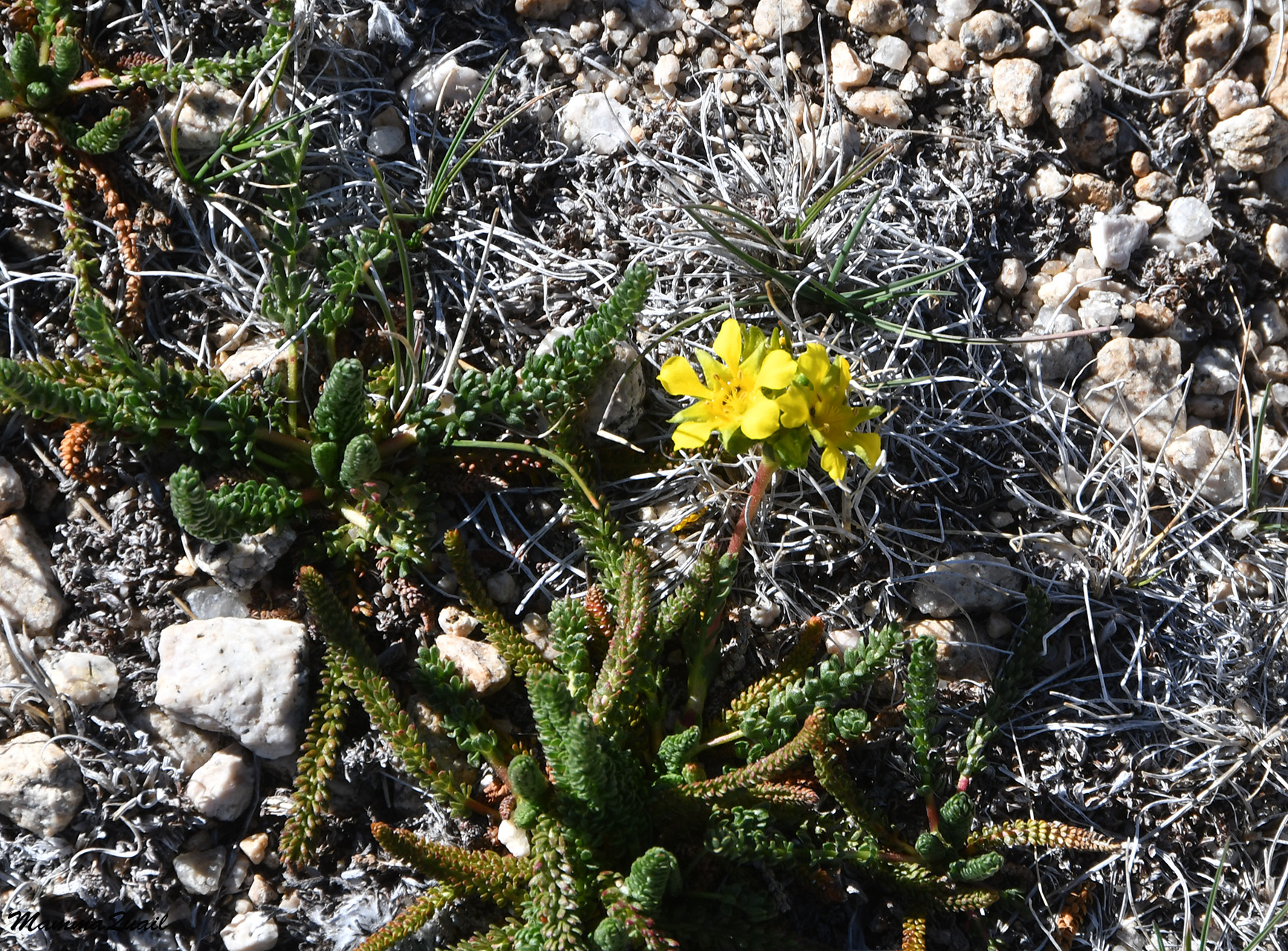
Now I also had the chance to see just how many gentian flowers were embedded in the green meadow grass.
 |
| Sierra Gentian, Gentiana holopetala |
Across the meadow and the creek I rejoined the South Fork Cottonwood Creek trail and followed it up and the low rocky ridge that separated the South Fork Lake from the group of Cottonwood Lakes. The slope was populated with foxtail pines, dense enough to be considered a forest yet separated enough so that only their shadows touched one another. Some of the pines had very interesting shapes, working my imagination.
 |
| The Kissing Tree |
Going up that ridge was much easier than I predicted it would be when studying the map. The trail however, didn't go directly to the Cottonwood Lakes basin but continued north a little dipping a bit into the down the eastern slope of the ridge.

The view from the eastern slope was of a beautiful green valley, a valley created and fed by the north fork of Cottonwood Creek. Had I chosen to take Cottonwood Creek Trail yesterday, I woud have come through this valley. 
It was there that I met the New Army Pass trail and took it westward, and right up that same rocky ridge, going toward Cottonwood Lakes. 
There are five numbered lakes in the Cottonwood Lakes basin, and a few other lakes that bare names rather than numbers. This basin is a popular backpacking destination by its own right - many people come up here to set their camp and chill there for a few days. I was merely passing through.
The New Army Pass Trail goes by lakes # 1 and #2. When I reached Cottonwood Lake #1 I was glad that I didn't insist on pushing my first day's hike to get there for the night. The water level was low and the area looked drier and not as welcoming as the South Fork Lake where I did stay. I didn't linger there, but kept on moving.
 |
| Cottonwood Lake #1 |
It didn't take me long to change my first impression of Cottonwood Lake #1 into a much more positive one. Despite the low water level the area of the lake was teeming with life. Despite the ease of the level trail I found myself slowing down to enjoy the wildlife activity.
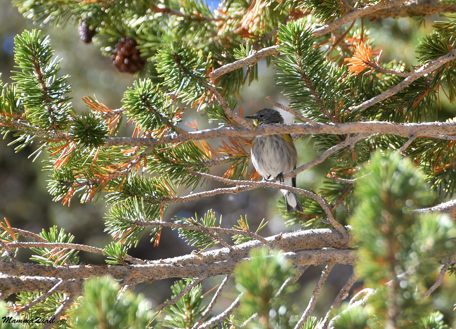 |
| Yellow-rumped Warbler |
There were many birds all over the place and I did my best to capture as many of them as I could on camera. I didn't have a birding lens, so even with my strongest zoom the more distant birds remained undocumented.
 |
| Mountain Bluebird, male |
Other birds were more considerate of me and stayed near the trail, making it easier to photograph them and harder to chose a photo from the many that I took.
 |
| Dark-eyed Junco |
Gazing west I could see the outline of the ridge where New Army Pass was. I passed the full part of Cotton Wood Lake #1 and continued along the dried out area, which was overgrown with grasses. That area too was full of wildlife activity.

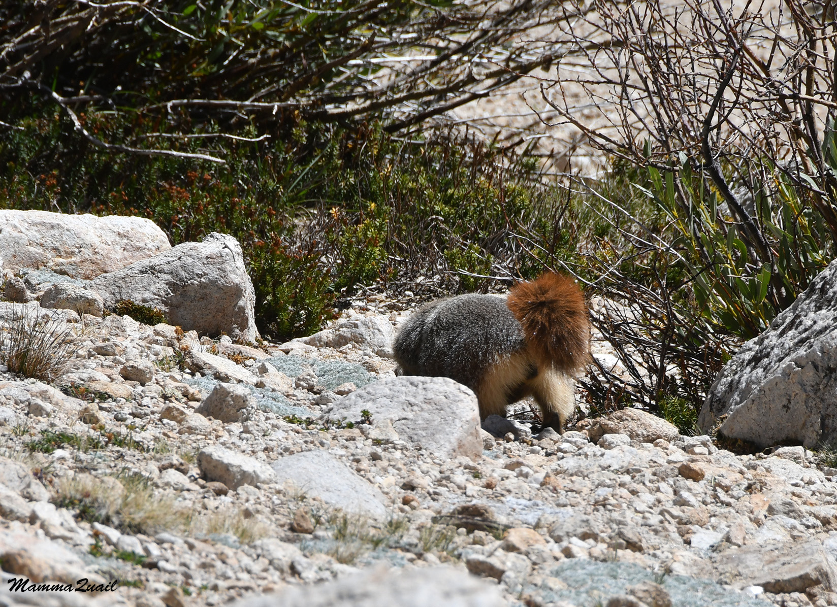
A bit off trail, on as rocky 'island' in that low meadow were a couple of busy marmots. I wasn't very close to them but I was the only human in the area. When they noticed my presence they ceased their action and after a short pause they both went underground, perhaps to resume their activity in privacy.
 |
| Yellow-bellied Marmot |
 |
| White-crowned Sparrow |
Although it wasn't visible yet, I knew that I'd be arriving at Cottonwood Lake #2 soon, so I increased my pace a bit. A chipmunk that was foraging near the trail darted off as I approached and paused momentarily on a rock before diving behind it and out of my sight.
 |
| Alpine Chipmunk |
When I came into view of Cottonwood Lake #2 I saw that it too was fairly low and that the water line was distant from the trail. I had plenty of drinking water still and I didn't want to walk into the grassy area so I continued further up the trail, looking for a spot where I could sit comfortably, preferably in the shade.
 |
| Cottonwood Lake #2 |
There were foxtail fines all over the place, and I counted on finding a shaded spot beneath one of them. I also loved the looks of many individual pines along my way. These pines are truly magnificent beings.
 |
| Foxtail Pine, Pinus balfouriana, framed by Cirque Peak |
The trail curved around the west side of the lake and after ascending a bit I found a nice place to sit in view of the lake. I took the time to rest and snack, and drink more water. While sitting there I heard the unmistakable sound of human speech. There were three backpackers coming up the trail at a fast pace. I don't know if they were aware of how loud their voices sounded to me, but after a morning of solitude and peace, the sound of their voices was harsh on my ears.

The backpackers nodded to me as the passed me on their way up without stopping. They marked the end of my day's solitude. From then on I saw a fair number of people, both backpackers and day hikers, who passed me on their way up to the pass. The day hikers I also met a second time as they were descending back, along with backpackers for whom Cottonwood Lakes was the wilderness exit point. 
After a satisfactory break I moved on. The trail was uphill, but for the most part the ascent was at a mild slope. Away from Cottonwood Lake #2 the trail cut through a large scree area that from a distance looked barren. At a closer distance however, I saw many wildflowers blooming between the rocks.
 |
| Fremont's Ragwort, Senecio fremontii |
The trail curved around the mountain side and the lake disappeared from my view. There were two more lakes up ahead, and I counted on them to fill up on water before going up the pass.

 |
| Mountain Coyote Mint, Monardella odoratissima |
Whereas yesterday the wildflowers were past their peak bloom season, here at the higher altitude they were blooming with maximal vigor. There weren't too many, though. Drought did slow down everything. But the pants that were blooming, were at their peak.
 |
| Indian Paintbrush, Castilleja sp. |
A movement between the rocks caught my attention - it was a squirrel, and it was getting away from me. I took it as a good sign that this squirrel was still completely wild, untainted by accessibility to human food.
 |
| Golden-mantled Ground Squirrel |
A bit higher and around the curve the trail neared a happy little brook. The sound of flowing water was music to my ears. According to my map the trail would cross the creek a bit further away. When I approached that spot I met a pair of backpackers filling up their bottles. These backpackers were coming down from the pass and when I asked them, they told me it was best for me to fill up on water here rather than later because the lake water ahead wasn't all that good.


The solo hiker moved on up the trail at an impressive speed while I stayed by the creek a bit longer after filing my bottles to snack some. But the day wasn't getting any younger, so eventually I got up and hoisted my pack on my back. It felt so heavy now, that it was fully loaded with water! And yes, it did slow me down.
 |
| Fleabane, Erigeron sp. |
When I reached Long Lake, the first of the two lakes that I had yet to pass before going up to the New Army Pass, I groaned with dismay. There was nothing wrong with that lake's water! There was absolutely no need to fill up at the creek's crossing. I felt stupid for listening to the backpackers couple but there was nothing I could do about it now other than massage my sore shoulders and adjust the heavy pack to distribute more of the weight on my hips.
 |
| Long Lake |
I considered stopping fr a break but decided to wait until I've reached High Lake, the next lake up the trail and the last one before the final ascend to the Pass. While I couldn't see High Lake from where I stood at the west end of Long Lake, I could see exactly where it was located - at the high end of the green slope. That greenery was fed by the spillway water of High Lake.

The trail didn't go there in a direct line but ascended left of the greenery. The slope was mild at first and then it steepened and I slowed down once more. The creek coming down from High Lake was mostly hidden in the vegetation but in a couple of places it was exposed to view.

I reached the top of the ledge where I expected the lake to be and found that it was actually somewhat further away, and to the north. To get to the lake the trail cut through a small forest of stunted pine trees. 
For the second time that day I saw a marmot. This marmot was completely nonplussed by my presence and didn't even lift its head to regard me.
 |
| Yellow-bellied Marmot |
When I reached the stunted trees I recognized them as whitebark pines, a high altitude tree that usually grows stunted and curved like bonsai because of the extreme mountain conditions.
 |
| Whitebark Pines, Pinus albicaulis, along theNew Army Pass Trail |
As I slowly made the last ascent to High Lake I noted as few more wildflowers along the way. They gave me a good excuse to pause for a short breather for I was panting heavily under my heavy pack. The day was getting hotter too, and it was already past lunch time. I decided to stop for a long break at High Lake.
 |
| Brewer's Lupine, Lupinus breweri |
By the time I reached High Lake I was so tired and sore so I seriously considered staying there for the night and not go on over the pass. I noted wryly that the water of High Lake was also perfectly fine for filtering as well, but this time I didn't beat myself more over listening to that couple by the creek. I ate, drank a lot of water, and tried napping a little bit. There was no good shade near the lake however, and no good place to even lie down. The one place that seemed to be suitable for camping there was already taken - a yellow tent was pitched at the east side of High Lake.
 |
| High Lake |
 |
| New Army Pass Trail |
It was there that the altitude finally caught up with me. Worried still about the possibility of getting altitude sickness, I limited my pace to keep my heart rate at a reasonable aerobic range. I Realized too that I probably wouldn't have the time for any more long breaks, but I was good with taking short breaks when needed, to drink, snack, and look at pretty flowers, miniature as they may be.
 |
| Nuttall's Sandwort, Sabulina nuttallii |

The wetter area on the spring side of the trail did support more plant life, and there I was seeing wildflowers that I didn't encounter earlier at a lower elevation.
 |
| Davidson's Beardstongue, Penstemon davidsonii |
After gaining some altitude I had a nice view of the entire High Lake, a view I didn't have while level with the water. From this standpoint I saw how limited the area of vegetation by the lake was, and that the entire lake circumference was very exposed with very little shelter. Good thing I didn't stay there.
 |
| High Lake |
Well above the tree line and with little other plants or wildlife, interesting rocks and stones attract more of my attention. They are very beautiful too.
 |
| Quartz |
I didn't see many butterflies that day. In fact, I saw very few insects on the entire trip. The best thing about it was the absence of mosquitos and f annoying flies, but other insects and invertebrates I actually like to see. They are interesting and important wildlife, and many of them are quite beautiful too.

Of the insects I did see, the vast majority were grasshoppers, at various stages of their life cycle. The one in the photo below is at its nymph stage, before maturing into a winged adult.

But probably the most beautiful insect I saw on this trip was a green sweat bee, a small solitary native bee that looks like a precious gem.
 |
| Green Sweat Bee |
The trail took me up the south-facing side of a large U-shaped valley. Facing me from south was Cirque Peak, looking oblong and not very peaky from my point of view. It looked barren and I assume that in years with better precipitation this mountain is snow-covered for the better part of the year.
 |
| Cirque Peak |
Facing south meant also that I was completely in the sun. I forgot to pack sunscreen with me and I realized that my left arm was getting red. I was glad when I reached the switchbacks part of the trail because it gave me some relief from the burning sun.
 |
| Oceanspray, Holodiscus discolor |
Another hour passed and I still had some ways to go before reaching the pass. I sat down for a short hydration and snack break, and for viewing the local grasses, which are hardy little beings, able to withstand the harsh mountain climate.
 |
| Squirrel Tail Grass, Elymus elymoides |
While I was sitting there munching away, the hiker that passed me at the creek crossing before Long Lake was coming down the trail. He stopped when he saw me and we renewed our chat for a few minutes. I had made it to the pass only and spent some time there before going back. He also commended on the nice progress I've made since the creek crossing, an observation that didn't fit my own feeling of being way too slow. We wished each other good hiking wishes then he continued downhill, fast and light as a rabbit and I rose to my feet and hoisted my pack while repressing a groan, and resumed my snail speed progress uphill.
 |
| Rockfringe Willowherb, Epilobium obcordatum |
Some of the alpine zone flowers I saw on my way were quite festive and beautiful, like the pink-flowered rockfringe willowherb in the photo above. Some were more modest in size and color, but that was compensated for by their pollinators. It occurred to me that the native solitary bees of the Sierra were quite colorful and beautiful.
 |
| Silverleaf Phacelia, Phacelia hastata, with a visitor bee |
I was getting closer to the pass and although I felt like taking another break I decided to push through and have my break all the way up. Having wings would have been nice, but I had to settle for only seeing wings, on a rock wren that's probably a local resident at that height.
 |
| Rock Wren |
 |
| Rock 'pancakes' |
 |
| View east from New Army Pass |
Once on the ridge I looked for a place to sit for the break I promised myself. There were no trees there, I was well above the tree line. While many of the rocks were good as seats, they were all well baked by the sun, and hot. There was very little vegetation up at the pass, not that I expected much at that height. There were the squirrel tail grasses and some really flattened lupine and buckwheat plants, but that's about it. Perhaps a month before I would have seen some annuals as well.
 |
| Oval-leaf Buckwheat, Eriogonum ovalifolium |
I don't know why but expected to have a grand view to the west, but there wasn't such a view from the height of the pass. Not that the scenery on the west wasn't pretty but my view was obstructed by the shoulder of the mountain. I looked around to find where the trail continued from there and followed it until I reached a sign that marked where the pass was. I continued a few steps down the trail and sat down for a break, a much shorter one than I had originally planned.
 |
| View northwest from the New Army Pass |
As I munched my snack I eyed with concern a trail on the opposite slope to the north of me. I knew that the west part of the New Army Pass Trail would drop into the deep valley of the south fork of Rock Creek, but I couldn't see where exactly. For a few moments I worried that I might have another uphill bit before going down, but then I remembered - New Army Pass was named this way because there was an (Old) Army Pass just north of the new one, rising from the other Cottonwood Lakes. The trail I was seeing was descending from the old pass.
 |
| Wallflower, Erysimum sp. |
There were very few wildflowers on the west sloe of the pass too, but they were different. They too however, were small and close to the ground.
 |
| Drummond's Cinquefoil, Potentilla drummondii |
It was some distance into the descending trail that the view opened up and I could see the the kine of faraway peaks that I knew were all west of the Kern River. I also had a good view of the valley below me, where I was about to go down to. To my dismay I saw that the creek below was completely dry. On the way up to the pass I had drank most of my water and was down to less than a liter. I would have to be economical with the water I had left. From the pass I had about 3.5 miles left to reach Soldier Lake where I planned to camp for the night. I expected to find water closer than, definitely on the main fork of Rock Creek.

I took a small sip of water and continued downhill. Going directly west I had the sun in my eyes. This also reduced by far the number of photos I took, and the number of those that turned out good. I was also a bit more pressed for time now, because it was getting late in the afternoon and I still had a good distance to cover to Soldier Lake. But I couldn't resist looking at yet another marmot on the way. They are so adorable (when they don't chew on cars and unattended backpacks).
 |
| Yellow-bellied Marmot |
Although coming downhill was considerably faster, it did create some new issues for me, the most problematic one being blisters. They weren't forming yet but I could feel the friction points forming and hoped that my skin would hold until I reached the camp site because I really didn't want to spend time on bandaging myself on the way there. The faster pace in the direct sun also got me thirsty and I paused frequently to take a sip and wet my mouth. I wanted to drink more but I haven't seen surface water yet. I kept looking though. When I reached the creek bottom I looked back at the pass I just descended from. The entire basin looked barren and dreary, a stark contrast with the forested and lakes-bejeweled slopes of the eastern side.
 |
| View east onto New Army Pass |
There was a forest ahead of me though, and I reached the place where the creek bottom was green. I was optimistic about finding water soon so I sat for a quick break, had a snack and drank nearly all of my water, leaving a sip's amount to swirl inside the bottle.

It was a much easier walk from there on, about time because the sun was getting low fast. I was getting tired and my muscles were sore. Once again I thought about how little prepared I was for this trip, physically.
 |
| New Army Pass Trail, west |
There was none happier than me when I finally reached the part of the creek that was running. I threw my backpack under a nearby tree and wend down with my bottles and filter to the water. I filtered, drank, filtered some more, and rested in the much welcomed shade. It would have been a good spot to camp too, and I seriously thought a bout it, but then decided to go on to my planned camp site at Soldier Lake. It was only a mile away.
 |
| A south tributary of Rock Creek |
A short distance down the creek I reached the Siberian Pass trail junction and turned north toward Soldier Lake.

A lovely meadow, now mostly shaded, welcomed me to the Soldier Lakes basin. My map had a yellow square mark just before the lake - the sign of a bear-proof food storage box. I followed the trail in that direction and I saw the box a bit off the trail, some distance from the lake itself.

I spent precious daylight time looking for a suitable site to pitch my tent. The west side of the lake which I originally thought to camp at, was closed for camping now, so I had to go back to the east side. Moving between the east and the west sides meant also crossing the little creek that cut through the meadow in between. I couldn't stay low by the creek - not only it is prohibited to camp by the water but the soil was soft and wet and unsuitable there. Eventually I found a suitable spot above the meadow, a couple hundred yards from the bear box and I made my camp there.

I cooked my dinner in the last of the day light, and after cleaning up and arranging the campsite I debated with myself whether I should go and place my bear canister in the bear box/ I was very tired by then and thought that simply setting the canister away from the tent as I do in places with no bear box would suffice, but eventually the more cautious voice inside me convinced me that if a bear box was placed there it means that bears are active in the area. So in near darkness I carried my food, stove and cookware over and secured them in the storage box. I was so tired when I finally entered the tent that I expected to fall asleep quickly and have a good night's rest. As it turned out, nature had other plans in store for me that night, but that's for the next blog post.
Link to the post of Day 3 of this trip
That was a very interesting day with a lot of great views. The green bee is very special
ReplyDeleteSome of the best views were that day :-) I love this area of the Sierra Nevada.
Delete