 |
Lower Rock Reek Trail
|
Date: August 31, 2022
Place: Golden Trout Wilderness, Lone Pine, California
Coordinates (of my campsite at Soldier Lake): 36.500913, -118.271001
Length: 6.5 miles
Level: moderate
On the second night of my 2022 backpacking trip I camped at Soldier Lake, and I was completely alone there. I was worn out after a long days hike which included going over New Army Pass at 12310 ft, and I expected to sleep well that night. What actually happened was that I had to get out of the tent twice after I already settled in (and as a special bonus I got to once again be awed by the super starry night sky). Then I finally fell asleep only to be woken up a short time after by the unmistakable sound of a bear shaking the metal food storage box about 200 yards away where I had stashed my food and cookware for the night. I heard that sound before when camping in Yosemite, and that's one of the sounds that once heard, it never leaves your system. In Yosemite I was surrounded by other campers who got to bang on their pots and pans to scare the bear away. Now however, I was alone and there was no chance in the world that I would go outside the tent and challenge the bear. I had to trust that the storage box will hold (it did) and that the bear wouldn't come to check out my camp site (thankfully he didn't). Needless to say, I got very little sleep the rest of that night.
Eventually I did fall asleep again, and not planning to cover too much distance on my third day, I allowed myself to sleep in a bit longer. The valley I was camping at had its opening to the west so the sun was taking its time to clear the mountain ridges around. I was already up and about by the time the sunlight hit the meadow at the valley floor.
 |
| Morning at Soldier Lake |
After yesterday's effort I decided to take it easy today. I took my time eating my breakfast and breaking camp and washed my clothes. It was well after 9:00 am, pretty late for me on backpacking trips, when I finally set out on my way.
 |
| My hike as captured by my GPS |
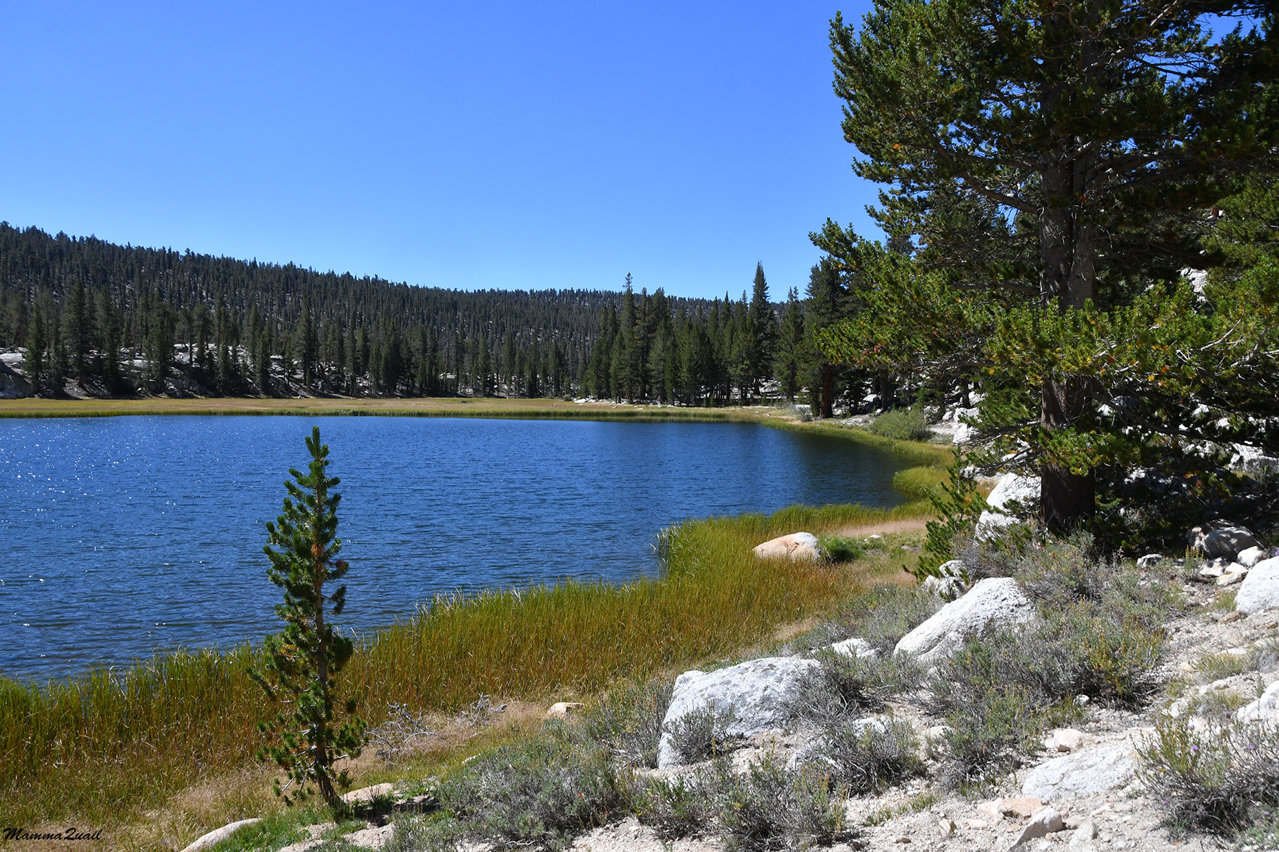
This was supposed to be an easy day. A day of mostly mild downhill walk for a distance of less than 6 miles. I planned it as a lazy day to let my body recover from yesterday's effort and give it time to adjust to the altitude. With that mindset I started my hike by crossing the creek and the meadow and waking north a bit to look at Soldier Lake. My campsite was not close enough to see the lake and I had arrived there last evening too late to enjoy the location and now I had the time. I found a nice spot by the lake, spread my washed clothes on the rocks to dry and my solar charger to charge, and enjoyed the morning sun. While gazing across the water I noticed an orange colored tarp moving between the trees and heard some faint human talk. I guess I wasn't completely alone in the area after all. These people however, were too far from where I had slept, and for sure they didn't keep their stuff in the storage box. I wondered if the bear had visited them as well.
 |
| Soldier Lake |
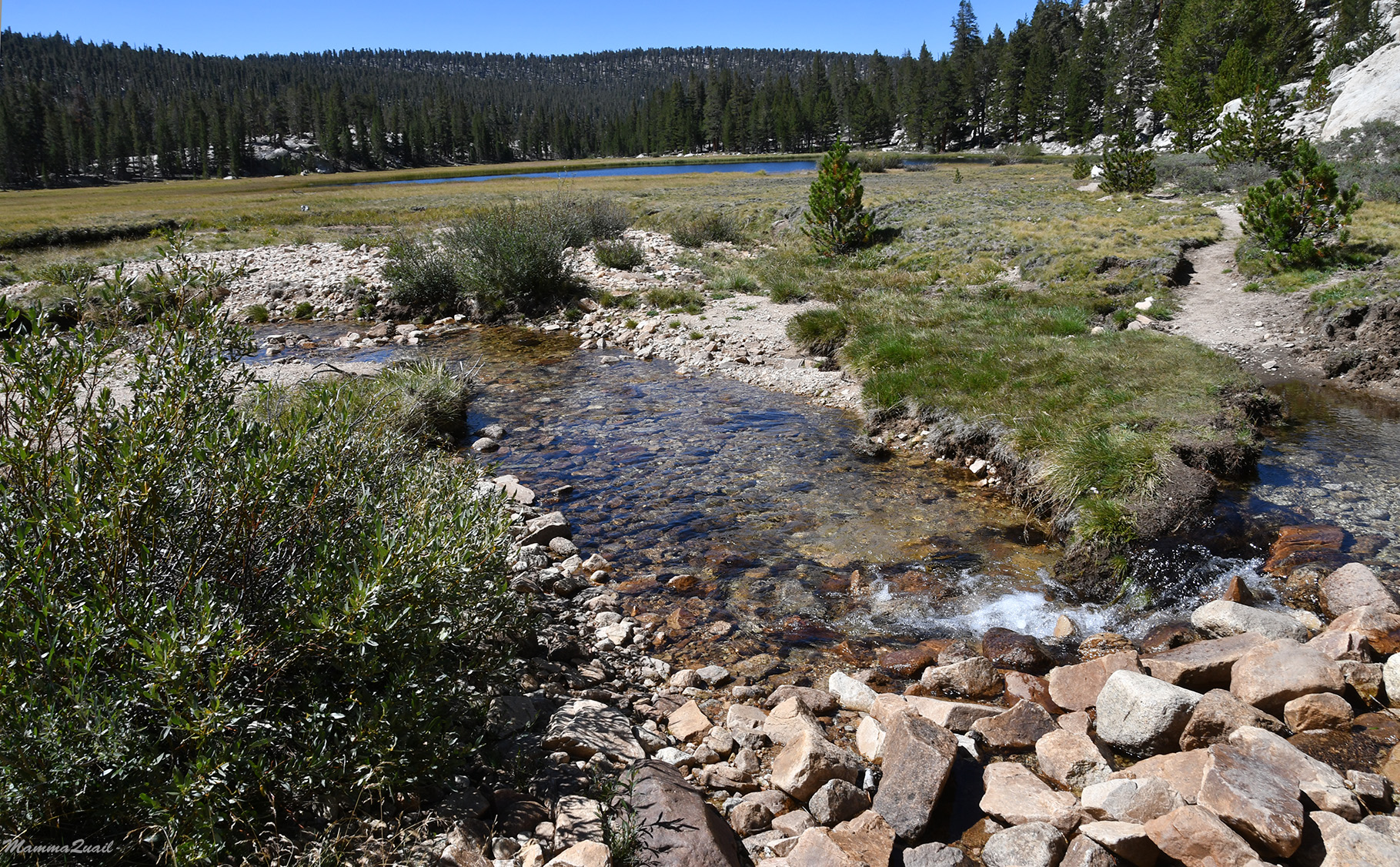
When I was ready to get going again I stayed north of the meadow, taking the Lower Rock Creek Trail. This trail would take me for 3.5 miles down Rock Creek to connect with the John Muir Trail (JMT) on which I would go north.
 |
| The meadow below Soldier Lake |
Leaving the upper meadow the trail soon plunged into the forest, and became rocky and steep in parts. It was there that the friction points in my feet notified me of their existence again, but since I was on the roll with my walking, I didn't feel like stopping to take care of these, which turned out to be a mistake.
 |
| Lower Rock Creek Trail |
One of the things I miss most when I go on backpacking trips is fresh produce. My daily diet consists of copious amounts of vegetables and fruit which weigh a lot, and on these trips I live on dehydrated, concentrated food that is light to carry and packs tightly into the bear canister. I was therefore very glad to come across ripe wax currant. On my early trips to the High Sierra I didn't know if these were edible to humans but since then I had educated myself and now I was enjoying some fresh berries on my hike.
 |
| Wax Currant, Ribes cereum |
I heard some voices ahead of me and sure enough, there were two backpackers coming up the trail I was descending on. They were on their way to the Army Pass (they had yet to decide whether they's go on the New or the Old pass trails). I told them where was the last spot to fill up on water before going up the very dry pass trail and they told me how beautiful the scenery was going to be for the next mile or so. Because I was hiking at a good pace so far I inquired about camping options after the JMT camp at the Rock Creek Crossing. They said that Guyot Creek, which was under a mile north and about 500 ft higher than Rock Creek Crossing camp had little water still flowing in it, but they recommended that I'd stay at the main JMT camp by the crossing. I thanked them and we separated our ways.
 |
| Lower Rock Creek Trail |
The two backpackers were right - the next trail segment was absolutely gorgeous. Large flat meadows, wildflowers, and the lovely Rock Creek whenever the trail came close enough to see it.
 |
| Alpine Gentian, Gentiana newberryi |
It was also shortly after I crossed paths with the two backpackers that I had my trail crisis. I was going downhill at an easy enough trail, and although I didn't get enough sleep (for the third night in a row now, including my pre-trip camping night at Yosemite), I didn't feel tired or sleepy. I was also going lower in altitude, so I'm not sure what had triggered it. It was like all of a sudden all my energy was drained at once, and I had to drop my backpack and sit down. My mind was immediately thrown back to my first solo backpacking trip, also at the Golden Trout Wilderness, only a bit more to the south. Then too, I had a crisis point. Then too, it happened on an easy downhill stretch, on my second day into that trip, the morning after going over a high mountain pass - the Mulkey Pass. Then it took me a while to understand what was going on and to properly take care of myself. With my current experience I knew this was the first warning sign of what could develop to altitude sickness.
 |
| Agoseris sp. |
Past the pass my options were three - to go on, to turn back, or to remain in place. Turning back meant going uphill again, and I wanted to avoid that. Staying in place was a nice enough option. I could find a place to pitch a tent nearby, and the creek was close so I'd have water. But going on would bring me even lower in elevation, and the trail was easy enough. Besides, one on the JMT there was a much better chance to run into other people who might be able to help in case things got worse. So I ate a high sugar snack, and I rested, and eventually felt better and ready to continue down the trail.
 |
| Sierra Gentian, Gentiana holopetala |
The two backpackers that crossed my path were right about the next section of the trail. It was indeed gorgeous. The trail stretched along a long and wide meadow which was green still and even had some wildflowers blooming between the grasses. For the most part is was a flat, easy walk, and I took the time to walk slow and recuperate, and to enjoy the hike. I crossed a large side creek spilling into the meadow by balancing on strategically placed rocks.
After crossing I paused and looked back, noting to myself the direction of the pass I came across yesterday. I also filled up my bottle with the creek's clear water before moving on. I didn't fill all
of my containers because I knew that for the most part of the day I'd be
close to Rock Creek.
There were fewer wildflowers than I'm used to seeing in these High Sierra regions. I was later in the season than I usually go, but I was also at the tail of two years with very little precipitation, and that might have had much more effect on what I was seeing.
 |
Wavyleaf Paintbrush, Castilleja appelgatei
|
There were also much fewer butterflies all around. Fewer insects in general. There was less for them to feed on and to pollinate.
 |
Checkerspot Butterfly
|
The trail passed near a shallow nameless pond at the north side of the meadow. I had already filled up my bottle so I didn't stop by the pond other than to look and to take photos. It was a very dreamy scenery there, very calm and beautiful.
I would have enjoyed the hike much more if not for my altitude-affected tiredness and the pain that was developing in my feet. I could feel the blisters forming despite the relatively flat terrain, but it was more than that. The soles of my feet felt hot and burning and points of pressure pain were forming in my heels as well.
 |
| Groundsel, Packera sp. |
I passed the large meadow and once again I was in the forest. The pain in my feet intensified on the sloped sections, and it was the downhill walk that was making it worse. I walked slow, made the best use I could of my hiking poles, and tried focusing on nature's beauty all around me to distract me from the pain.
 |
| Lower Rock Creek Trail |
One way I could take my mind off of my sores was to look fr wildflowers. There weren't many in the forested areas but I kept looking for the plants that were blooming.
 |
| Brewer's Lupine, Lupinus breweri |
The trail neared the creek again and I thought it might be nice to take my shoes off and dip my feet in the water. I decided to do just that when I take my lunch break.
 |
| Lower Rock Creek Trail |
But as soon as I begun harboring thoughts of lunch and a foot bath the trail rose away from the creek. I actually welcomed the small uphill section. Although I was altitude-tired and slow, my feet thanked this change in slope direction.
 |
| Lower Rock Creek Trail |
I came upon a large wood gate and a sign that prohibits grazing beyond that point. I knew I was due to cross from the Golden Trout Wilderness into Sequoia National Park and I wondered if that was the park's boundary.
 |
| Lower Rock Creek Trail |
Shortly past the gate I was going downhill again. A movement in front of me grabbed my attention - it was a little tree frog, the only frog I've seen on this entire trip. The frog was hopping across the trail, away from the water. It had something in its mouth - a butterfly. I wondered why didn't the frog swallow the butterfly. I don't recall ever seeing or hearing of frogs carrying their pray away from where they've caught it.
 |
| Tree Frog with lunch |
The trail neared the creek again but stayed above it. I wanted to find a good spot for a long break but in the meanwhile I settled for a short snack break. It felt good to be off my feet for a few minutes.
 |
| Rock Creek |
The forest seemed to open up a bit and with the intensified sunlight there were more wildflowers along the trail.
 |
| Wandering Fleabane, Erigeron glacialis |
I crossed another side creek on my path, a tributary to Rock Creek. This one was interesting because it cut its path through a sandy area, the first I've seen on this trip. It was fairly fine sand too, and the creek flow revealed the nice orange color of the pebbles underneath the sand.
I yellow butterfly of a kind I don't see often fluttered before me and settled on a blooming rabbitbrush. I It paused there for a split second before taking to the air again, but I managed to take a photo.
I was pleased to see more and more wildflowers along the trail although for the most part I didn't make the effort to take better photos than what I could shoot on the go from standing position. I was to fatigued to stoop down or squat for a better photo angle.
 |
| Sierran Woodbeauty, Drymocallis lactea |
Parts of the trail were lined with flat stones to make it stable, and possibly easier for mules and horses to walk on. I knew this type of tiled trails from Yosemite. Personally, I don't care much for this trail lining. I find it easier to walk directly on the soil.
 |
| Lower Rock Creek Trail |
Parts of the creek were lined with a thicket of willow bushes. I was surprised to see a group of willows that were yellow. Willows don't senesce like that and I think this was the effect of stress, possibly of drying up after a shift in the course of the creek.
 |
| Stressed Willows |
The lovely mint aroma told me of Monardella plants nearby. Sure enough, I found some lush Monardella, or coyote mint plants in bloom near the trail. I was tempted to pick a few leaves for my evening tea but decided against it and left the plants untouched.
 |
| Mountain Mint, Monardella odoratissima |
The forest opened up and once again I was walking in a meadow. The day had grown hot, I was tired, and my feet were screaming in pain. It was prime time fr a long break. My map indicated that I should cross the creek and there were nice shading trees on the other side so I looked for a place to cross. Ahead of me , across the meadow and some more forest was a stand-alone peak. I didn't pay too much attention to it at the time, but that was my first view of Guyot Peak.
 |
| Rock Creek and Guyot Peak |
It wasn't clear where the creek crossing actually was. I could see many little paths where people might have crossed and in one place there were logs lined up across the creek but they didn't look stable enough and I was too fatigued to try and balance across, even with the help of my hiking poles. It appeared to be that wading was my best option, so I found a spot where it seemed to be less muddy and I sat down and took off my shoes.
 |
| Northwest Cinquefoil, Potentilla gracilis |
The moment I placed my feet in the water I felt my pain wash away with the chill of the creek water. It's hard to describe the sense of overwhelming relief that I felt. The cold water quenched the burning that I felt in my soles and numbed all the sore spots. For a few long minutes I simply sat there, enjoying the cool feeling of my feet in the water. Eventually though, the direct sun on my head and face prompted me to get up and walk across the creek. Barefoot, I climbed the low grassy bank and waddled along a narrow foot path into the nearest shade where I found a rock to sit on. I remained barefoot throughout my lunch break, enjoying having my feet free of constraints and allowing them to dry in the warm air. Before wearing my shoes again I did what I should have done in the morning before setting out of my camp - I pulled out my blister treatment kit and I bandaged my sore toes. I was surprised that I had only two blisters - It sure felt like I had many more.

I didn't feel like wearing my shoes again but it was time to get going. I was surprised at how good I felt when I finally got up to continue my hike. The crisis I had since mid morning was completely gone - I felt invigorated and energized, and my pains have subsided. I resumed my walk at a much faster pace than I've had all day.
 |
| Lower Rock Creek Trail |
It didn't take me long to arrive to the JMT/PCT junction. I paused briefly to look around and took the turn to the north and continued striding.
 |
| John Muir Trail |
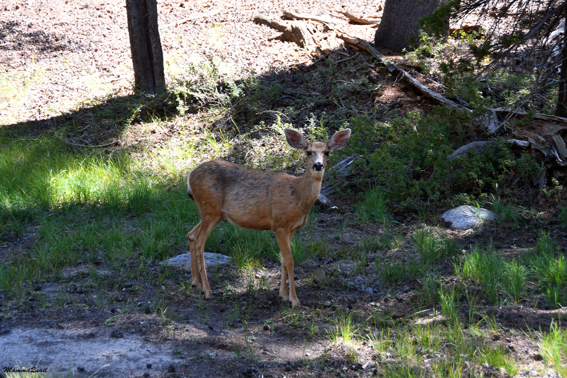
As I was walking down the trail I felt that I was being watched. Sure enough - by the side of the trail stood a large deer, the first I saw on this trip, and eyed my as I walked by. He didn't look alarmed but he wasn't relaxed either.
 |
| Black-tailed Deer |
When I was having my crisis I was sure that I'd stop for the night at the Rock Creek Crossing camp area. Now I realized that I would get there sooner than I anticipated. Having felt much better now, I decided that I should push on the extra mile or so uphill to Guyot Creek.
 |
| John Muir Trail/Pacific Crest Trail, in sight of Guyot Peak |
I crossed Rock Creek Meadow, looking for the creek crossing and the camp area. It was still a bit ahead though. There was a sign pointing toward a ranger station off to the right but I didn't go there to check it out.
 |
| MountainRagwort, Senecio integerrimus |
The trail neared Rock Creek again. The crossing would come up soon but meanwhile I was walking along the creek and enjoying the sound of water flowing.
 |
| Rock Creek |
I spotted a larkspur flower near the creek, the only one I saw that entire trip. It was quite late in the season for larkspur to bloom.
 |
| Larkspur, Delphinium sp. |
Another deer was gazing at me, a bit further away from the trail this time. When I looked in his direction I saw two more deer sitting in the vegetation further uphill. Those deer were the last I saw on this trip.
 |
| Black-tailed Deer |
When I reached the Rock Creek Crossing I saw there a number of tents already. All the people I saw there were men, most looked older than myself. All of them were in various positions of relaxation. One was sitting with his feet in the creek (I could relate to that!), another lying in his half-opened tent reading a book (now, that's dedication - carrying a book on a backpacking trip!), another was enjoying a hot beverage. Rock Creek Camp is a campground regularly used by JMT/PCT backpackers and I expected that more would arrive before nightfall. There was plenty of daylight left and after checking with myself that I was fit for the feat, I crossed the creek and moved on.
 |
| Rock Creek Crossing |
The last lag for the day was to hike up about 500 ft more and get to Guyot Creek. Once again I trusted the word of others, the two backpackers that crossed my path earlier that day. I trusted that Guyot Creek will be running. I therefore filled only one bottle at Rock Creek before beginning my ascent.
 |
| JMT/PCT north bound |
I walked uphill in a very calculated manner. My navigator watch also measures my pulse and I decided to walk only up to a certain pulse level so I would not get winded. This worked just fine - I was walking slowly but continuously with very few pauses. Most of my pauses were to take photos of interesting sights along the way. 
The trail between Rock Creek and Guyot Creek is about 3/4 of a mile of mostly switchbacks on a steep forested slope. As I got higher a nice round peak became visible to the south, and getting more and more exposed with each switchback turn I took.
Despite my slow pace I did gain elevation quick. The view to the east also opened up revealing the high, tree-less ridge that was the boundary of the Horseshoe Meadow area. The direction that I descended the pass from was hidden behind the trees to the left.
There were very few flowers along the path. Of the plants that did bloom I recognized the Sierra Chinquapin bushes, more by the distinct semen odor of their male flowers. The smell wasn't as strong as I had experienced on previous hikes, and the presence of developing fruit indicating that these bushes were too past the peak of their bloom.
 |
| Sierra Chinquapin, Chrysolepis sempervirens |
At about half the way up (height rather than distance) I sat down for a short snack break. A squirrel eyed my from afar, then hid in the rocks. I was glad she didn't show any sign of being habituated on human foods.
 |
| Golden-mantled Ground Squirrel |
Rested a bit, I resumed my hike. Going uphill was easier on my feet but it was demanding on my energies and I was still experiencing the effects of the high altitude. In fact, one of my reasons to wanting to push it to Guyot Creek was to not spend the night below 10,000 feet. The last lag of that day had brought me back to the 10K+ height zone. As I ascended the last few switchbacks the forest thinned and opened up more. The trees were now nearly all the red-barked foxtail pine and the earth was dry. I was nervous about the possibility of not finding water in Guyot creek. I knew that if there wasn't any water there I would have to turn back and spend the night at Rock Creek.

I didn't see Guyot Creek until I was almost upon it. No sound of running water heralded its presence. When I was right at the creek though, I did see water, a mere trickle, flowing silently between the smooth rocks. The water was clean and there were water holes large enough to dunk a bottle in for easy filling. A big stone rolled off of my heart, I was relieved and relaxed.
 |
| Guyot Creek |
There were a few places near the creek where it was obvious that people had camped before and there was no one else around so I could take my pick with no hurry. I built my camp and prepared dinner. This time I arrived my camp site with enough time before nightfall to eat and arrange the camp area and enjoy some quiet time before sunset. There were plenty of giant bolete mushrooms there but I didn't feel like cooking any of them.
 |
| Pine Bolete |
While I was getting ready for the night I saw a few people coming down the trail from the north. Only two of them stopped to say hello and to ask if Rock Creek was a better camping area to which I answered that yes, Rock Creek was better suited - more flat areas for tents, a storage food box, a great water source, and naturally, more people. They didn't ask me why did I choose to go to the isolated spot at Guyot Creek but I answered that question to myself in my mind - I wanted to be at a higher elevation, and I preferred to not have company too close.
 |
| Sunset at Guyot Creek |
Worn out but relaxed and glad for having met my day's goal without pressure I entered the tent shortly after the sun disappeared behind Guyot Peak. It was early still and I thought I'd read a bit some material I prepared on my phone, but after a few minutes my eyes became sore from the phone's bright screen and I turned it off. I spend a little more time studying my map even though I already knew the route ahead of me. Eventually my fatigue took over and I turned off my flashlight and tucked myself inside the sleeping bag. This night, the third of this trip, I finally slept well. As it turned out it was the only night on this trip on which I did sleep well. It was also the last night I'd be camping in isolation.
A link to the blogpost of Day 4


a bear, altitude sickness, soar feet...oh deer ;-)
ReplyDeleteThe deer was on the forth day :-)
Delete:-)
Delete