
 |
| Wild Turkey, males |
Date: February 17, 2025
Place: Ed R. Levin Park, Milpitas, California
Coordinates: 37.447041, -121.849269
Length: 1.5 miles
Level: easy
Last Presidents Day we discovered, quite surprisingly, that both our chikas, who are now college students, had a regular school day. On days like that Pappa Quail and I like to go hiking someplace together. That day however, we were both quite busy with things that piled up and when we were done with our chores there wasn't much daylight time left. I suggested going out anyway, to do a shorter walk in a close by place, so we went to Ed R. Levin Park, which is fairly close to our home. We hiked a number of times in Ed Levin Park, but every time previously we hiked around Sandy Wool Lake. This time we drove to Spring Valley Pond, which was an area of the park that we haven't seen yet.
The first thing that caught my eye as we approached the pond was a sign saying that fishing is only allowed for children. Not wanting to fish for any child I joined Pappa Quail who was scanning the pond for birds.

The pond had very few waterfowl, and most of them were swimming near the shores. A pair of mallards swam away as we approached the shore but a few coots hung by the water edge.
 |
| Spring Valley Pond |
Pappa Quail wasn't very enthusiastic about photographing mallards and coots but he did take some photos on my request.
 |
| American Coot |
We didn't plan on any long hike. The trails in that area of the park aren't very long anyway. Our plan was to simply go around the pond and then walk a little along the creek. Eventually we did go up the hill on Spring Valley Trail though, and had some really nice views from there.
 | |
| Our hike as captured by my GPS |
We started strolling down the trail, following the northeastern shore of the pond. We walked slowly, looking for birds and chatting. Left of the trail was a large lawn area, and a sole great egret stood there, possibly in ambush of gophers.
 |
| Great Egret |
At the edge of the lawn sat a birder on a folding tripod stool and aimed his huge lens-equipped camera at the egret. I tagged at Pappa Quail and he too took the majestic bird's photo.
 |
| Great Egret |
The narrow connector trail to the other side of the pond was partially flooded and muddy. We walked carefully and managed to get to the other side without too much mud on our shoes. I hoped that there was no more mud on the trail ahead.
 |
| Nature Trail |
The view of the pond from the southern trail was mostly blocked by vegetation. When we did have a clear view of the water we noticed a few more ducks, among them a male northern shoveler. Most of the ducks that we saw were concentrated on the west shore where a couple of park visitors were feeding them.
 |
| Northern Shoveler |
T the west edge of the lake we continued straight on the Nature Trail that extended along the little creek spilling from the pond. Thick clouds have gathered above and I wondered if it'll rain. So far it didn't, and we continued hiking on a fairly dry trail.
 |
| Nature Trail |
Trees and bushes grew between the trail and the creek, but whenever they parted we could see the light flow down below us.

There were many large oaks near the trail, and also some fallen trees, in various stages of decomposing. Many fungi were growing on these fallen, rotting trees but one of them was particularly vivid - the witch's butter fungus.
 |
| Witch's Butter Fungus |
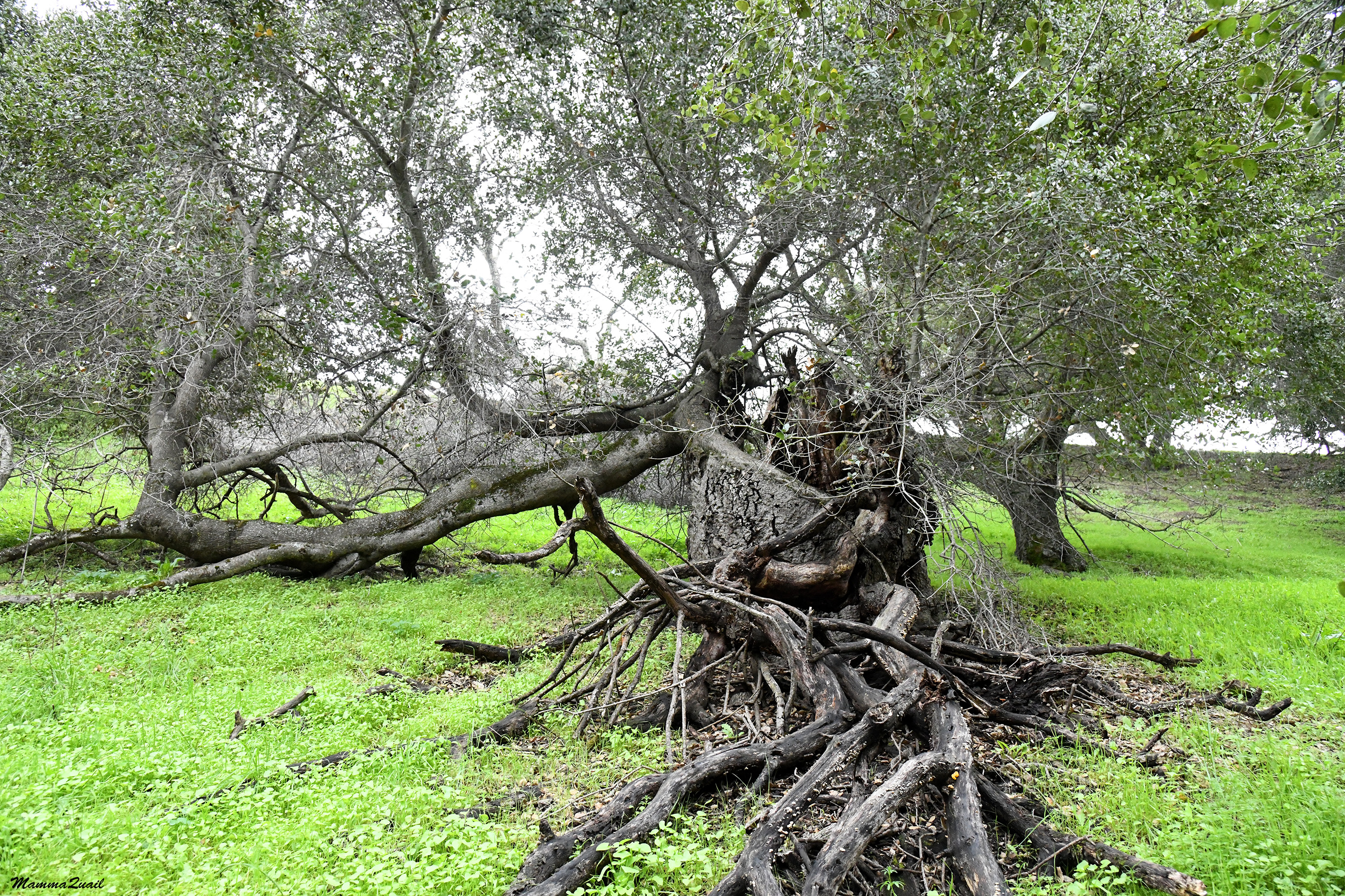
Not all trees die when they fall. We did see one tree that broke and fell over, but it was still attached to its roots and its branches kept growing, twisting back in the upward direction. I am always amazed by the resilience of trees and their ability to grow around their problems.
The large oaks formed a beautiful canopy above the trail. i was taking photos of this pretty avenue when Pappa Quail noticed a rafter of turkeys crossing the trail.
 |
| Nature Trail |
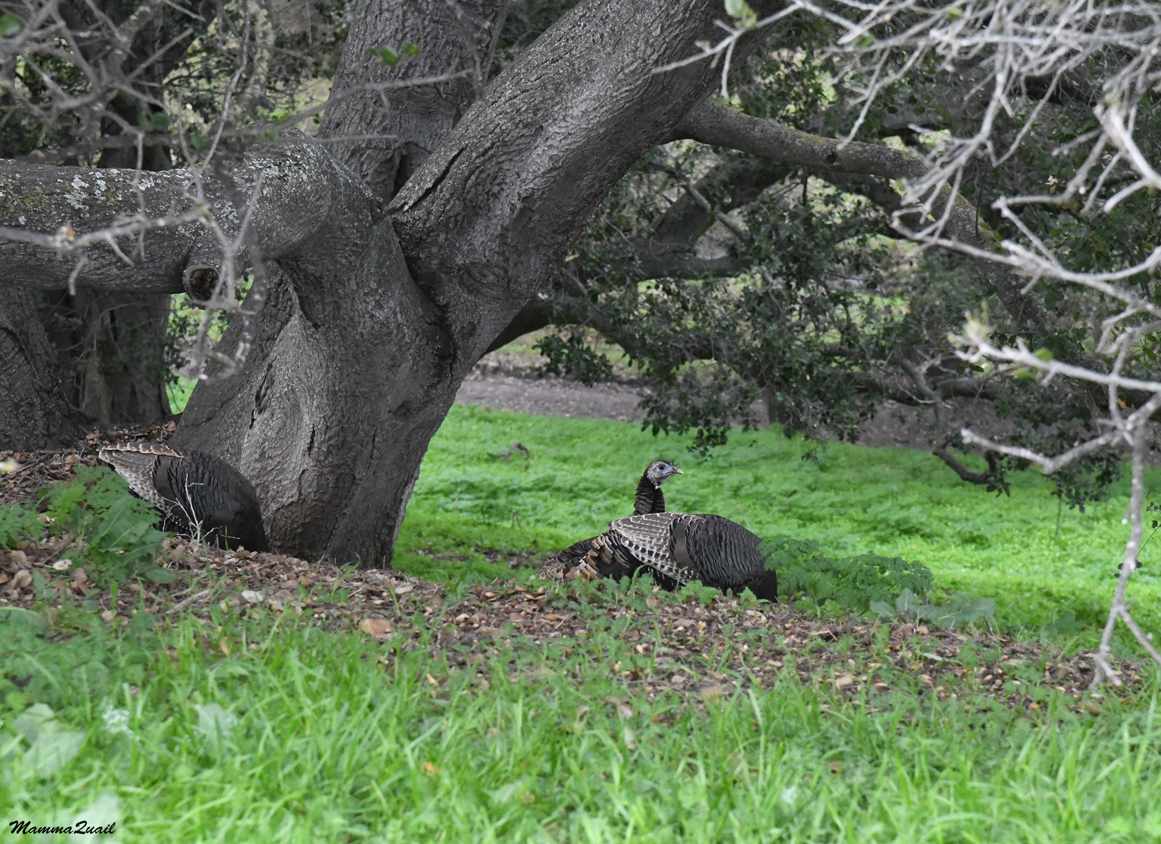
As big as these birds are, they can move pretty quickly when they want to. The turkeys ran fast across the trail and up the hill. At first I thought they were all males because all the toms were ahead of everyone else.
 |
| Wild Turkey, males |
The hens followed the toms, at a much slower pace. They would also pause every now and then, and peck at the ground.
 |
| Wild Turkey, female |
A few toms remained below near the creek. They looked at us with clear disinterest. I tried gobbling at them but they didn't reply. Perhaps my turkey dialect was off.
 |
| Wild Turkey, males |
The creek was a small one, with a mild flow. Behind it was the access road to Spring Valley Pond. That was the road we came in on. It was quiet now, and the few cars that we did see traveling on that road were leaving.

We left the oaks behind us. The vegetation near the creek grew much thicker and denser. It was mostly willows, and they were beginning their spring bloom.
 |
| Willow, Salix sp. |
Below the willows I recognized the budding leaves of roses. I couldn't tell whether these roses were a native California species, or introduced plants that established themselves in the wild.
 |
| Rose, Rosa sp. |
The trail split. Our original plan was to simply backtrack on the nature trail, but now the plan seemed too short so we decided to return via the Spring Valley Trail that extended up on the hill.
 |
| Spring Valley Trail |
As soon as we gained some height the wonderful view of Mission Peak, all in green, came before our eyes. From this angle the iconic pyramid that makes Mission Peak's summit wasn't visible. Below us was the dark line of oaks that marked the creek that we walked along. Across the creek I saw a large patch of yellow flowers. It looked pretty, but likely they were either mustard or sour grass, both of which are invasive plants in California.
 |
| Mission Peak |
The yellow wildflowers that bloomed near the trail were definitely mustard. Although they are introduced plants, I still enjoyed seeing their bright color, especially on a dark, cloudy afternoon.
 |
| Mustard |
A large oak tree, still bare of leaves, was growing downhill from the trail. The tree looked old and majestic. It wasd hard capturing all of its canopy in a single frame.

There were more oaks near the trail higher up the hill. Most of these oaks were live oaks - they were evergreen. Below one of the oak trees we saw again the rafter of turkeys. There were even more turkeys at the grassy hilltop, and I chose that photo to head this blog post - the turkeys were certainly the highlight of that hike.
One of the trails that lead up to Mission Peak begins at the Ed Levin Park, from the Sandy Wool Pond area. When I decided to join the expedition going up Mount Shasta I started my training by ascending Mission Peak on that trail.
 |
| Mission Peak |
The trail curved to the south a bit to reach the high point. From the top of the hill we had a grand view of the south part of the San Francisco Bay and the low lands that surround it, as well as the peninsula mountains on the other side.
 |
| Bay View |
Meanwhile, Pappa Quail found the first bird on this hike that he was truly interested in seeing - a single black-shouldered kite was perched on a tree. It was far from the trail but a few steps forward brought us to a better viewing and photographing position across from the kite.
 |
| Black-shouldered Kite |
After a nice walk up the ridge the trail started descending down to the east. In that part of the hike, the trail bordered some private lands. We walked along the huge backyards of the local residents there, which had big mansions and horses in a fenced run.
 |
| Spring Valley Trail |
A small bird was perched on one of these fences and Pappa Quail took some effort to get a good photo of the bird - a Say's Phoebe.
 |
| Say's Phoebe |
We resumed our descent down the trail. The Spring Valley Trail didn't go directly to the pond but reached a small parking area east of the pond. As we made our way down we saw a young Sikh couple in bright traditional clothes posing for celebratory photos. The photographer was very focused on the young couple and completely ignored the bluebird that was perching on a tree branch right above him. As it happened, Pappa Quail didn't notice the bird either, or otherwise didn't feel inspired to photograph it.

Across the parking area was a large, solitary eucalyptus tree. I don't normally photograph non-native trees but this eucalyptus was in full bloom and looked very beautiful.

I don't have a photo of a bluebird from this hike but I did convince Pappa Quail to take a close up photo of the eucalyptus blossom.
 |
| Eucalyptus |
We walked quickly down the trail northeast of the Spring Valley Pond, which was the same trail we started on. The great egret was still on the lawn, although somewhat further away. It attracted a number of admiring observers, who kept a respecting distance, thankfully. The seated birder was there still, in the same place we saw him at the beginning of our hike, and he was still looking at the great egret.
Pappa Quail was a bit disappointed with the bird yield of this hike. i asked him if he wanted to check out the Sandy Wool Pond area, but he declined. It was time to go back home.


