
 |
| Sunset at the second Big Five Lakes |
Date: June 18, 2021
Place: Sequoia National Park, Three Rivers, California
Coordinates (of my camp at Little Claire Lake): 36.420891, -118.521155
Length: 11.5 miles
Level: strenuous
Place: Sequoia National Park, Three Rivers, California
Coordinates (of my camp at Little Claire Lake): 36.420891, -118.521155
Length: 11.5 miles
Level: strenuous
On the second night of my June 2021 backpacking trip I didn't sleep all that well. It was warm, and it also rained on and off throughout the night so I couldn't open the rain fly to air my tent and ease the heat. Unlike the first night, I wasn't worried about people coming over to my campsite, so I allowed myself to linger inside the tent for a while before I was compelled to get outside. I was outside the tent in time to watch the sunrise.
 |
| Sunrise at Little Claire Lake |
The sun rose but didn't really break through the cloud cover. It took a long time for the morning to brighten. On the previous evening I was too busy getting done with my evening routine before the rain to pay close attention to the trees near the lake. In the morning I was walking between them in silent admiration. These were large foxtail pines, gorgeous and old. Many of them were leaning sideways and I wondered if that was the effect of heavy snow.

After breakfast I filtered more water and broke camp. Today I planned to get at least to the Big Five Lakes complex. Maybe even to Little Five Lakes, although that might be pushing it.
 |
| Little Claire Lake |
Little Claire Lake was a fine camping spot. Remote and peaceful. I got my backpack ready and stood for a while at the lake shore, gazing at the calm water. Beyond the lake on the horizon poked a few pointy peaks. I immediately recognized the slanted one on the left - that was the formidable Sawtooth Peak. I smiled, remembering the grueling climb of its western slope on my 2016 trip. I toyed with the idea of returning by that route, going over the pass from the east side. For the moment I pushed the idea from my mind. It was time to get going.
 |
| Nuttall Sandwort, Minuartia nuttallii |
There's no direct path connecting Little Claire Lake. I would have to go around the mountainous mass to my north, and the first part of circumventing it would be going down to Soda Creek and then down the creek itself for a good while. The first part would be entirely downhill, most of it on an easy, almost level trail.
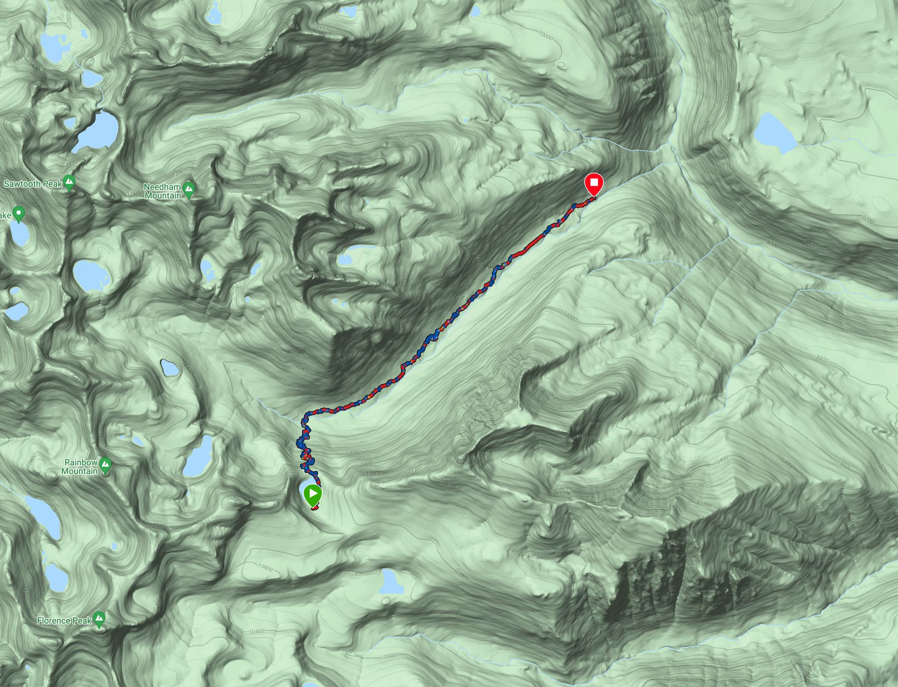 |
| The first part of my hike, down Soda Creek, as captured by my GPS. 5.8 miles |
I
found the trail and walked around the eastern shore of Little Claire
Lake, making my way to the lake's spillway and the edge of the big drop. The trees opened up and I had a fantastic view of the upper Soda Creek valley and the formidable ridge of Sawtooth Peak and Needham Mountain.
 |
| Sawtooth Peak (the peak in the photo's center), and Needham Mountain (the large peak on the right). |
I couldn't resist taking a closeup of Sawtooth Peak. It looks more formidable from the west side but no less striking from the southeast.
 |
| Sawtooth Peak |
I turned my back on Sawtooth Peak and looked ahead to where my trail was taking me. Down below be was the deep gorge cut by Soda Creek, stretching to the
northeast to meet with the Big Arroyo. I took a deep breath and started down the switchbacks.
 |
| View down the valley of Soda Creek |
Part way down I noticed a green triangle in the valley below. The shape and color looked very artificial to me, like a weird shaped golf course. But there weren't any human-made developments in this area as far as I could tell, certainly none marked on my map. Later, when I enlarged the image it showed a triangular patch of what looked like corn lily plants. That was the end of my conspiracy theory of an alien landing spot.
 |
| Corn Lily Equilateral Triangle |
The slope down to Soda Creek is very steep and the tail switchbacks often. In the high part there were large patches of large scree partially stabilized by trees. Elderberry bushes bloomed here and there in the conifer clearings, small on the outside but possibly long-rooted underneath, hugging the rocks and reaching down to the water-holding soil.
 |
| Red Elderberry, Sambucus racemosa |
One of the switchback turns placed me where I had a clear view east (and slightly north) to a ragged ridge, the same I saw from Franklin Lake the day before. Without the rain I could see it better, and I think this is the ridge of the Kaweah Peaks.
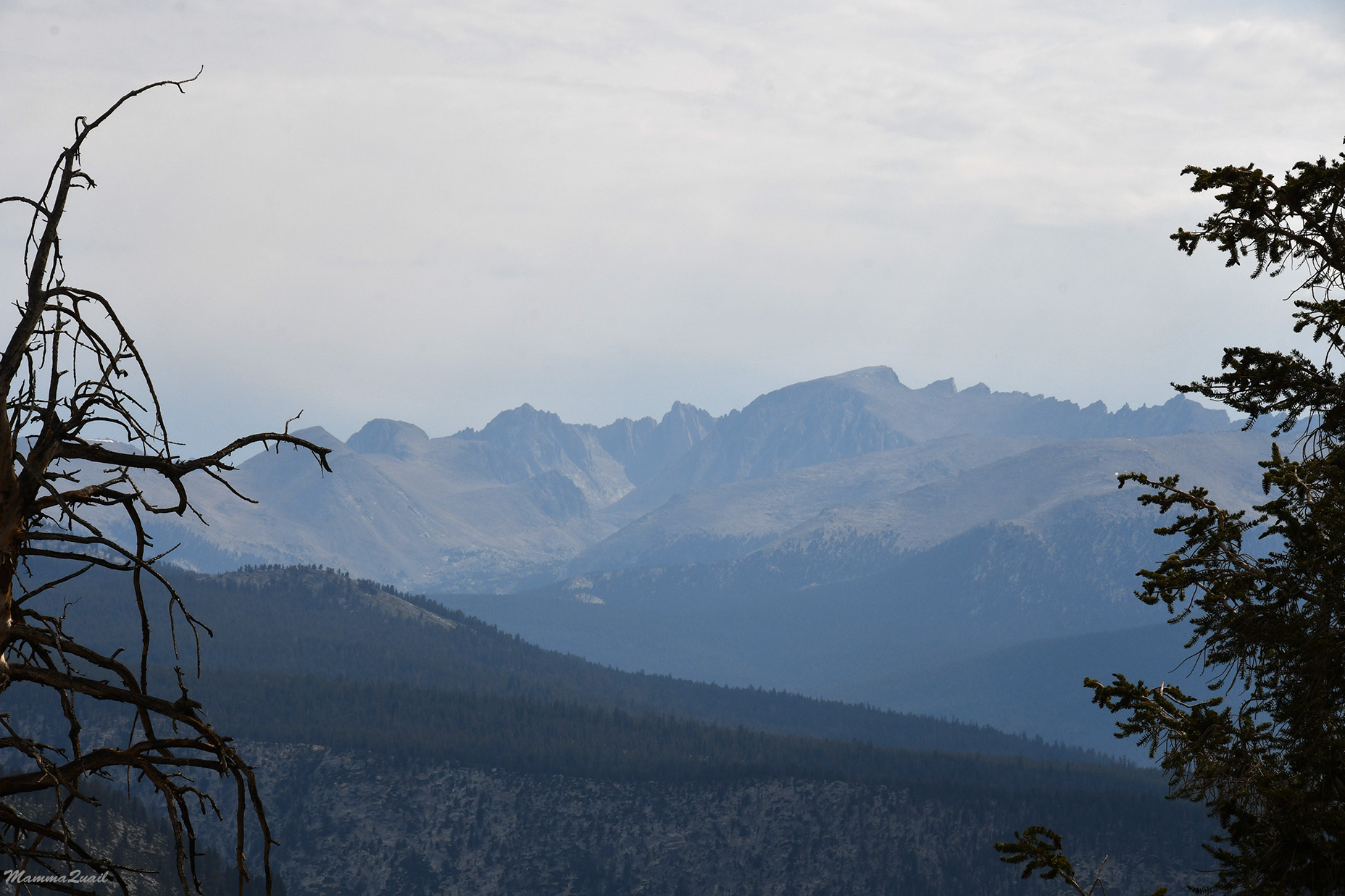 |
| Kaweah Ridge |
The lower and closer to the creek I got I saw more wildflowers. I saw delicate, white violets like those I saw on my 2016 trip near Spring Lake, not so far from here. Spring Lake will always be for me the embodiment of the High Sierra heaven, and the violets reminded me of that.
 |
| Macloskey's Violet, Viola macloskeyi |
Too early in the season for flowers and certainly too early to see any fruit - the forest floor was dotted with mountain strawberry flowers and the promise of some sweet fruit to come.
 |
| Mountain Strawberry, Fragaria virginiana |
I reached Soda Creek and found that the water wasn't carbonated at all. I wonder if the name came from a carbonated spring somewhere in the creek's basin. I crossed the creek and picked up the trail on the north side.
 |
| Soda Creek |
There, ensued the easiest five miles of the entire backpacking trip. In this part, Soda Creek's downstream slope is very mild and the trail along it is nearly level. Getting closer and farther from the water, most of the path is through a uniform conifer forest of pines and firs with relatively little change in scenery. It was the perfect segment to go at a fast pace on.
 |
| Soda Creek Trail |
There was a sense of some gloominess to the forest bottom. A gloominess that reminded me of my lonely days at the Golden Trout Wilderness, just across the Great Western Divide from where I was now. I haven't seen any human soul all morning and I wondered if I'd see any today.

This time however, I didn't mind being alone. I walked quickly down the path. At times I would stir and realize that I lost myself in thoughts but most of the time I was looking around. There were always some pretty flowers to look at.
 | |
| Sierran Woodbeauty, Drymocallis lactea |
At the floor of a coniferous forest is exactly where this so hard to photograph lousewort is blooming. There were many of them, but I got very few good photos of this one. On the last day of this trip I'd have much better success with this species.
 |
| Pinewood Lousewort, Pedicularis semibarbata |
Most of the Soda Creek Trail is within the forest but here and there I crossed a clearing and got a nice view of the mountain ridge to my south. It gave me a really nice perspective on the depth of the gulch I was walking through.

It was pine blooming time, and copious amounts of pollen was blowing from the trees with every little shake. The orange male cones are quite beautiful.

The trail dipped near the creek once more and I enjoyed a short break in a wetland area that had some flowers and thankfully not too many mosquitos.

At times the trail distanced from the creek, going up the slope a little bit before descending once more to the water level. Drier and more exposed, these trail sections were going past a different variety of wildflowers.
 |
| Spreading Phlox, Phlox diffusa |
The sky too, was shifting above me. Clouds varying in size and grayness moved overhead and I moved fluid between sunny and overcast. The bright colored flowers stood out brightly against the granite gray.
 |
| Wavyleaf Paintbrush, Castilleja applegatei |
On one of these open areas I found the first mariposa lilies of the day. There were many of them in a small area of small granite rocks separated by gravel. Fully open, these lilies made me happy for the rest of the hike.
 |
| Leichtlin's Mariposa Lily, Calochortus leichtlinii |
Moving quickly along the trail I was making a good time. I thought about making it all the way to Little Five Lakes but I didn't know how long it'll take me to get uphill on the second part of the hike.
 |
| Soda Creek Trail |
Meanwhile, I was enjoying the beautiful colors of the wildflowers blooming along the trail.
 |
| Crimson Columbine, Aquilegia formosa |
My regular High Sierra botanical acquaintances were blooming along this trail as well. i never get tired of seeing them.
 |
| Sierra Beardstongue, Penstemon heterodoxus |
I was following the same patch of sunshine for a while, seemingly walking in the same direction and at the same speed as that of the cloud above me. The hike was uneventful, and I was completely alone. It was a great time to just be with myself and my own thoughts.
 |
| Soda Creek Trail |
I didn't catch up with that sunny spot I was chasing. Rather, the cloud moved on and I was immersed in blissful sunshine pouring through behind the cloud that has passed.
 |
| Mountain Phacelia, Phacelia orogenes |
I remember thinking at some point that these five miles of Soda Creek Trail were the longest segment of my hike without any major change in elevation, direction, or scenery. Not to say that it was monotonic, it sure wasn't. One of the surprises I saw along that trail was a species of gentian that I've never seen before, a rare species endemic to this area of the Sierra Nevada alone. And the butterfly was cute too.
 |
| Kern Frasera, Frasera tubulosa |
Those five miles of Soda Creek Trail were gone almost without noticing. The Soda Creek Trail continued on, down to the Big Arroyo, and eventually to the Kern River. One day I might take that route. This time however, I was turning north, going up to Big Five Lakes.
 |
| The second part of my hike, about 5.7 miles |
The beginning of my ascent was relatively easy. The slope begun at a mild grade, on which my gait was only slightly shorter and my pace almost the same as when I was walking down the Soda Creek Trail.

I didn't rush the climb, however. As I was going higher there were more wildflowers to look at and appreciate. Large slabs of granite pried the forest trees apart and light poured down to the south-facing slope I was ascending.

The exposed rocks were excellent places for lizards to sun themselves. Most of them darted away as soon as they saw me approach but there were a few that braved it out and even posed for the camera,

Then there were the forested areas too, where I walked through large stands of (mostly) pine trees. As the trail curved northwest, the forest dominated more and more of the trail.
 |
| Trail |
The forested areas also held their surprises for me. I was thrilled to see some snow plants in bloom - this ephemeral wildflower belongs to a parasitic plant that lives underground on the roots of conifer trees and pops above ground only to bloom, and it is magnificent.
 |
| Snow Plant, Sarcodes sanguinea |
Other, less conspicuous wildflowers also added their colors to the forest floor.

This part of the trail wasn't going leading all the way up the ridge but going up and across the southeast edge of it. Up I did get high enough to have a view of the confluence where Soda Creek met the Lost Canyon and slightly beyond they merge with the Big Arroyo.
 |
| Where rivers meet |
To my north was the big plateau that I saw the day before from Franklin Pass. It was funny to see it so close and realize that I covered all that distance since yesterday. The cloud cover to the north was nearly complete but a sole peak was lit with brilliant sunlight. It looked like it was floating over the dark, green plateau.

Below me lay the deep gulch curved by Lost Canyon. One of the lakes at the top of that creek's basin is Columbine Lake, which was a missed destination on my 2016 trip when me and my friend took the wrong turn up Sawtooth and ended going down to Spring Lake. Now I was toying with the idea of going up Lost Canyon and getting to Columbine Lake from the east.
 |
| Lost Creek gulch |
I came across a little tributary creek just in time to fill up my water bottle. I kept walking uphill along that side creek for some distance. I was nice to walk along the water again.

The wet creek side provided another special growth place for plants, of species different from those I saw growing on the exposed rocky areas or on the dry forest floor.
 |
| Brewer's Miterwort, Pectiantia breweri |
Among these were high mountain ephemeral plants that I wouldn't have seen blooming had I come later in the season.
 |
| Few Flowered Meadow Rue, Thalictrum sparsiflorum |
I moved on through the forest. The trail was nearly level here and I expected to start dropping down to the gulch soon.
 |
| Trail |
Just as I was thinking that I wanted a change in scenery, the trail did start descending downhill, mildly at first. I was also getting away from the tributary creek and I could no longer hear the water near me. A mint fragrance filled the air and I soon found its source - a mountain mint was blooming along the trail.
 |
| Mountain Mint, Monardella odoratissima |
I was descending through areas of large granite slabs that supported little vegetation. What grows on the exposed granite is small, and is restricted to the soil-accumulating cracks in and between the rocks.

The hardy, ubiquitous yarrow was blooming there too. I'm so used to seeing it everywhere that I nearly always ignore it. It is pretty though, and deserves the attention.
 |
| Yarrow, Achillea millefolium |
I didn't stay by the granite slabs for too long though. The trail continued its descend and plunged back into the forest where I saw little lupine shrubs dotting the rich brown mat of fallen conifer needles.
 |
| Lupine, Lupinus sp. |
All the birds I've seen until then were little juncos that were too hyperactive to photograph. I could hear other birds around up on the trees, jays mostly, but none were getting out in the open for me to see. It was only on my way down to Lost Canyon that I saw a bird that was perched in full view and didn't fly away the moment I raised my camera.
 |
| Townsend Solitaire |
I reached down to the creek level and I could hear the water somewhere behind the trees. The intersection where I'd have to make my next decision was coming up soon but I had a hard time deciding. Going up all the way to Columbine Lake and then across Sawtooth Pass to Monarch Lake would be nice, but would shorten my trip by a day unless I decided to stay an extra day by the lake. Going back here from Columbine Lake and up to Big Five Lakes would add one more day, a day which I couldn't afford adding to this trip.
 |
| Trail |
A bog near the creek had some orchid plants growing in the grass. Nearly all the orchids there, (and those I've seen before and didn't mention) were not open yet. It was too early in the season. I was happy to find one that beat the others and was already blooming.
 |
| Scentbottle, Platanthera diletata |
A sole marmot welcomed me as I crossed its path, then darted off further from the trail. Up ahead in the distance I could hear human voices and I snapped into heightened awareness - I was no longer alone in the wilderness.
 |
| Yellow-bellied Marmot |
I reached the creek crossing and the trail junction and sat down to rest and eat and to refill my water. While I was resting I saw three young men coming down lost Creek Trail. They looked tired and one of them had a full-face mosquito net. I had my bug repellent on me which was sufficient now but I remembered how badly I wanted one of these face nets on my 2019 Yosemite trip.
 |
| Lost Canyon |
The men had come down from Columbine Lake, they told me, after they had crossed the Sawtooth Pass. They too were heading to Big Five Lakes but the badly needed rest. Going across the Sawtooth Pass from the west is extremely strenuous and all three men looked spent. I was therefore a bit surprised when they bade me farewell and started right away up the hill. As I was talking with them I made up my mind to stick to my original plan and continue to Big Five Lakes. Columbine Lake and the formidable Sawtooth would wait for me for another trip. I finished my filtering and started up the hill too.
 |
| Trail |
I usually walk slowly and I'm used to being the slowest hiker around but I wasn't surprised when not far up the trail I run into the trio again. They were sitting on a log by the trail side looking tired. One of them looked 1saw exhausted he didn't even raised his eyes to see me and kept moaning. His friends kept encouraging him, saying that they' walk slower. I mentioned something about altitude effect and got head nods in reply. There was not much I could do to help,I only hoped that they'll be sensible enough to not push their group member too much and get him sick.

I continued uphill. For some time I could hear the other hikers' voices floating up to me from below but eventually they disappeared. The trail was switchbacking, which made it easier to ascend. I came upon a large fallen tree that I had to bypass, but other than that there were no more obstacles along the trail.
 |
| Trail |
Soon I was high enough to get some nice broad vies again. Rugged mountain peaks became visible between the trees and the clouds were breaking off without any rain, letting sunshine and blue sky through again.

At the top of the ascend I found a pretty, nameless pond next to the trail. t looked inviting and I stopped there for a few minutes. I thought I could hear voices behind me again - perhaps the hiker trio were coming up behind me after all.
 |
| Pond on the way |
The afternoon was growing and I had to get going again. for a while the trail was level and easy and I walked at a quickened pace, heading north toward the Big Five Lakes complex.
 |
| Trail |
There were two lake clusters ahead north of me - the closest was the Big Five Lakes and further north were the Little Five Lakes. Either would be good for camping. On the morrow I planned to go up and across Black Rock Pass and the Little Five Lakes was closer to it. Going to Little Five would mean more walk today and less tomorrow. I figured I could decide on than after reaching the Big Five.
 |
| Brewer's Mountain Heather, Phyllodoce breweri |
There was some uphill going again, and all of a sudden the forest changed from lush green to charred fire scars. The entire south face slope of the hill south of Big Five Lakes basin had been through fire.

The fire wasn't very recently, and I was glad to see regeneration happening already, although I knew it'll take many years for the forest to recover.
 |
| Baby Pine |
I passed the fire scar and across the ridge the trees were green again. Below me I got a glimpse of one of the Bog Five Lakes. I was also getting tired. Thinking f how pooped the other hikers were, pushing themselves to their limits and maybe beyond that, I decided that I don't need to push myself that much and that I should stay by the Big Five Lakes tonight.
 |
| Big Five |
A gap in the trees on the way downhill revealed the Kaweah Ridge to the northeast. I told myself that I should have a trip there as well some time.
 |
| Kaweah Ridge |
I came across an old and rusty hammer of the kind that was use. d to crack rocks. It might belong to trail improvement workers of the National park. It was strange to see it like that near the trail though.

When I emerged from the trees I came upon the first of the Big Five Lakes and found it to be very beautiful and inviting. I also found it very crowded. Every possible camp site was already occupied and there were people all around and some even inside the lake. I even came upon the couple that I saw arguing on the first day of my trip on the Farwell Gap Trail. I don't know if they recognized me when they nodded at me as I passed their camp site. They seemed all at peace now though.
It was getting late and was too tired to go all the way to Little Five Lakes, but I also didn't want to stay with the crowds, so I decided to go uphill just a little bit, to the next lake in the Big Five complex.

Turning my back to the first lake I started uphill again. This time I had to push myself mentally, because I was already ready to stop. Just a little further, not much.
Southeast loomed Needham Mountain over the lakes. I paused every now and then on my ascent to take a look at the views.
 |
| Neadham Mountain |
Through a gap in the trees I saw the first of the Big Five, the one I just left behind, far below me. I was ascending higher than I anticipated. Where was that next lake?

It turned out to be just under a mile to get to the next lake over, nearly all uphill. When I reached the height of the trail I could see the first of the Big Five so small below, and the view wide and open across the plateau of the Big Arroyo and across the peaks Kern.

Then there was a trail junction and a trail spur leading to the rest of the Big Five Lakes. I turned on the spur and there was a bit of a downhill walk to the next lake. I stopped to breathe a little near a curiously shaped foxtail pine. I really needed to get there soon because I was getting exhausted.
 |
| Foxtail Pine, Pinus balfouriana |
It was lake in the afternoon when I finally reached the second lake of the Big Five complex, and I was happy to find myself alone there. In slow motions I pitched my tent and had dinner. I really was tired and I was looking forward to a good night's rest.
 |
| Sunset |
The last remaining daylight I sat by the lake and looked at the reflection, to tired to even think. Today I walked the longest distance on this trip, covering much ground. It was a good day, but tomorrow I'd be facing my biggest challenge of this trip - the Black Rock Pass.

Darkness fell and I went inside my tent. All night I kept dreaming or imagining that hikers are passing my tent on their way to the next lake over,
Wow.... long hike... Nice flowers and views but I'm disappointed of the no soda at soda creek :)
ReplyDeleteLong and worthy! Ues, I would have liked some soda too :-)
Delete