

Place: Mineral King, Sequoia National Park, Three Rivers, California
Coordinates: 36.470975, -118.554916
Length: 1.7 miles of no trail cross country path-finding
Level: Strenuous
It was still dark when I woke up in the morning of the forth day of our trip.I would have liked to stay in the sack some more but I had to answer nature's call. The air was quite chilly and dark clouds covered most of the sky. The clouds in the east just began to light up when the sky started dripping large, sporadic raindrops.
 |
| Pre-dawn |
"But it's likely to get more intense," I added.
My friend exited the tend. If I was chilly, she was downright cold. Shivering, she wend down to the water while I started heating up water for the morning tea and watched the morning getting brighter.
 |
| Dawn |
It didn't take long for the blue patches to again disappear behind the cloud cover. By the time tea was ready it was all gray once more.
But then, all of a sudden, a rainbow appeared on the west. A beautiful rainbow shaft reaching from the clouds to the mountain ridge. We sipped out tea and enjoyed this wonderful treat until it slowly faded.
 |
| Somewhere over the rainbow ... here I am! |
We had our tend next to a small Sierra foxtail pine with a canopy so low that it touched the ground. Despite its small size the tree was healthy and bore many cones on its branches. My friend, seeing that I was interested in this trees had suggested that I'd try to capture all the female cone stages in one photo. She reminded me of that on the morning of our departure and I gave it the best shot I could, keeping in mind the relative darkness and the draining camera battery. In the upper left quarter of the photo there is a first year cone - the year of fertilization. It is small and dark, and not quite in focus. Slightly behind it and even more blurry is a branch bearing male cones. These only last for the couple of months it takes to mature and produce copious amounts of pollen. By the time we were fertilization was over and there was no more pollen left to shed. In the upper right quarter of the photo there is a second year female cone. It is light green and its scales are tight-shut. It wasn't covered with resin like similar stage cones I've seen of its close relative, the Great Basin Bristlecone Pine. If this species does resin their female cones, it didn't show on the one that I photographed.
At the middle bottom of the photo there is an older cone, one that already opened and released the seeds - the pine nuts. Below the tree and outside of this photo the ground was covered with old female cones at various stages of slowly turning into mulch and compost.
 |
| 3 stages of female cones. Sierra Foxtail Pine (Pius balfouriana) |
We managed to pack everything before the rain started again. Foreseeing that the rain will get stronger we covered ourselves with rain gear. It wasn't cold (at least, not in my opinion) and my concern was mainly to protect my camera.
My camera - after the disaster of losing my primary battery to carelessness on our first night, was now working on my backup battery, which I had to somehow make sufficient for the rest of our trip. On the morning of our 4th day it was at half strength and I was optimistic. I didn't expect to photograph as much that day. For one, it was raining now in earnest and I don't like to take my camera out in the rain. And then, how could that day possibly surpass the splendor of yesterday's paradise?
As it turned out as was very wrong, and happily so. The hike from Spring Lake to Cliff Creek campground was entirely amazing and was also the richest in sights as well as in botanical pleasures of our trip. After long considerations and harsh slashing I ended up with over 80 photos for that trail, and I don't want to cut down any more. So to keep the post in readable length I decided to split it into two posts. Here I share about our pathfinding hike from Spring Lake to the Black Rock Pass Trail and in the following post I'll continue about our hike down the trail all the way to Cliff Creek campground.
 |
| Our hike from Spring Lake to Cliff Creek Campground as captured by my GPS. The no-trail part highlighted in purple. |
There is also a geophysical logic to splitting the post at that place, because it was also about the transition point between the alpine terrain and its ethereal beauty to the lower, woodsier levels, that had very different looks and feel to it. It was like transitioning between two different worlds, and each deserves a full account.
I wasn't thinking about any of that at the time we were ready to leave Spring Lake. The rain had stopped again but ahead we could see the curtains of downpour awaiting us. I welcomed the rain. It had made it mentally easier for me to leave paradise behind.
 |
| Rain Ahead |
We remained to the north of Cliff Creek, which was the side where we would eventually meet with the established trail. We found a relatively easy place to go down the rock ledge that was the base of Spring Lake basin and started making our way along Cliff Creek.

Pathfinding is a slow business. The terrain didn't look all too challenging when we looked on it from above and by expert standards it probably wasn't. Still, we had to push through thick vegetation, balance on sharp, unsteady boulders across fields of scree, hop across tributaries and rivulets, some with steep and muddy banks, scramble down high rock ledges, and do all that in constant drizzle.
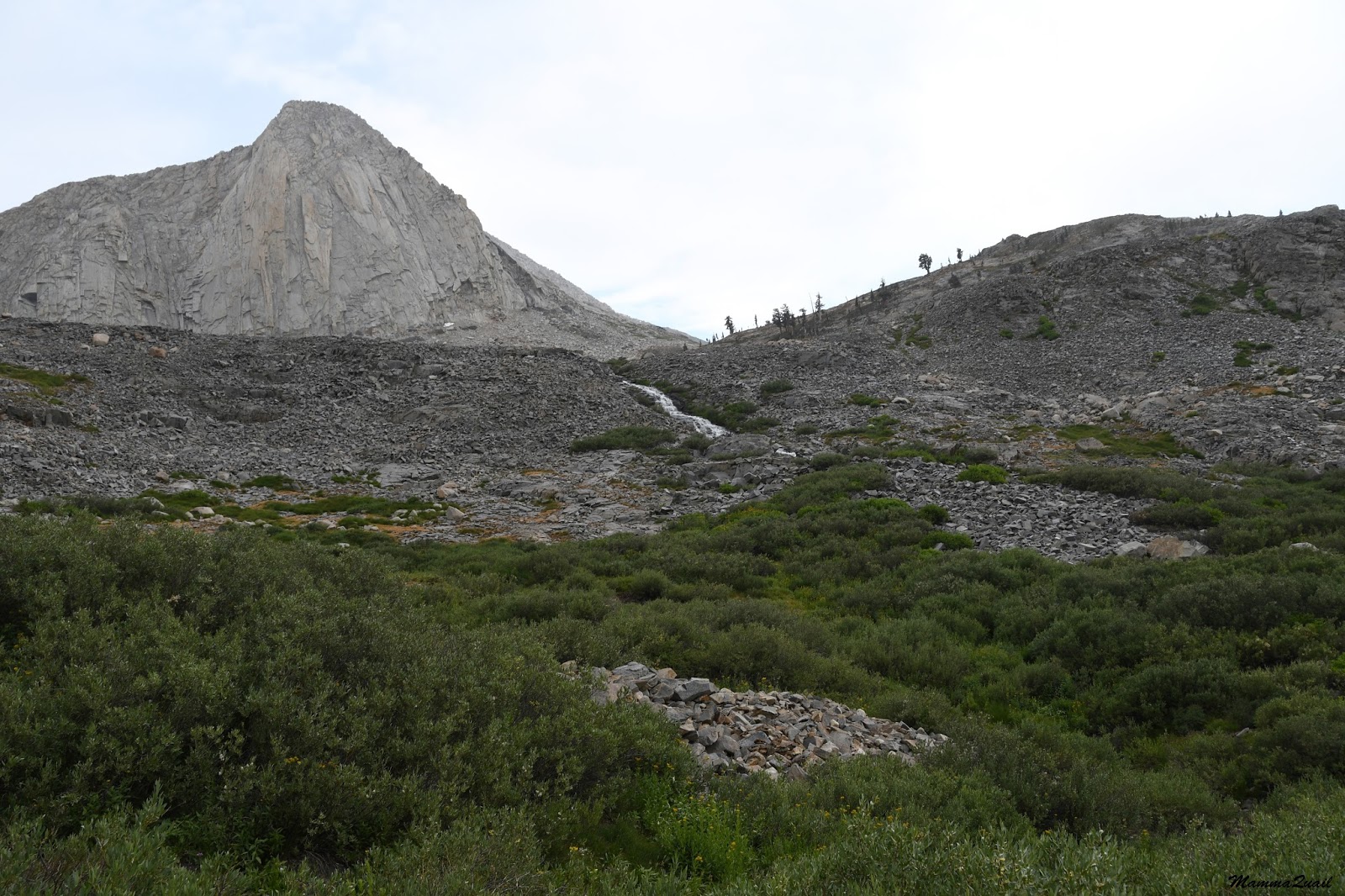 |
| Cliff Creek spilling out of Spring Lake. In the back - the huge granite peak we camped under. |
We were also concerned about treading as light as we could, for we didn't wand to damage the local vegetation any more than was necessary.

We knew that at least two people had passed that way before us earlier that week, and that they did it twice - going to and from Spring Lake along Cliff Creek. Soon we had found their tracks. It was sad to see how much an effect a single foot print can make on the fragile wetland vegetation. It was even sadder to think that we were most likely having the very same effect on the vegetation as we walked. We didn't have a choice - we arrived Spring Lake by mistake and we had to get out. We made the best effort to tread in the footsteps of those who walked before us and avoid making any new trails.
It also serves as an excellent reminder of why one should stay on the trail (whenever there is one) and not cut corners or get into the vegetation without a sound reason. I just hope the downtrodden plants will bounce back next spring.
 |
| Footprint Damage |
Like going down huge steps the creek flows from one rocky ledge to another. Down the rock it goes in a small series of cascades and then it settles into a flatter area and widens out into a beautiful wetland, thickly grown with lush and vibrant vegetation.
 |
| Sierra Penstemon (Penstemon heterodoxus) |
We heard bird songs in the bushes too, but the singers remained hidden, from us or from the rain, or both.
We made slow progress, keeping along the main creek whenever we could. We had a brief refreshment break near one of the slow creek ponds but quickly moved on when the rain got stronger.
 |
| Pacific Mountain Onion (Allium validum) |
We didn't have a distinct sunrise that morning because of the cloud cover. The few blue patches of sky that hovered above Spring Lake had remained there, and we were walking under a completely gray and dripping blanket of clouds. It felt very dark, and for Bay Area residents - it felt like winter. The wetness, the grayness, the intense greenness of the vegetation - all a natural part of the alpine summer. Winter there, of course, looks much different.
Like the paradise photos of my previous post, I did very little in altering these photos - left dark on purpose, I hope to retain that rainy feeling of that hike.
 |
| Looking back upstream |
The creek veered to the left while the path of least resistance pulled us to the right. In that place there was actually visible trail, made by people treading this way earlier in summer. We followed that trail and it took us across a mild slope of old scree that was now overgrown with vegetation, the plants on that slope seemed to be all in bloom, presenting a wonderful display of colors.

The rain had stopped. We took off our backpacks and explored the blooming field. Some of the wildflowers looked very familiar, although I could not tell whether they are the same species I know from the lower lands.
 |
| Indian Paintbrush (Castilleja sp.) |
Others were unique to that exclusive mountain community. The lily in the photo below is a species that's unique to that region of the Sierra Nevada.
 |
| Kelley's Lily (Lilium kelleyanum) |
We went down to the creek to look at the cascade. On he other side of the water there were cushions of yellow-blooming composites.

It was one of those times I regretted not having the big zoom lens with me. I wasn't willing to carry it with me, however, so I had to settle for the maximum zoom my general lens had.
 |
| Clasping Arnica (Arnica lanceolata) |
We were walking for two hours now but looking back I could still see the large monolith that's towering over Spring Lake. Our progress was very slow indeed.

Every now and then we had to cross a tributary that flowed down from the Eisen Range to join Cliff Creek. On each such crossing we had to find our way through a dense thicket. Sometimes we had to backtrack and look for another way. I kept looking for paths made by previous hikers. I became very good at tracking human travelers in that wilderness.
And on one of these tributary crossing I found a little surprise :-)
 |
| Sierra Tree Frog |
Each time we crossed a tributary we were immersed again in the wetland-riparian plant communities and the wonderful wildflowers that were blooming there at the time.
 |
| Marsh Checker Mallow (Sidalcea ranunculacea) |
We were thoroughly enjoying the color splendor of the alpine summer at the High Sierra. The fresh air, the amazing bloom, the quiet solitude, and the wholesomeness of the place. We walked downstream slowly, loath of leaving it all behind.
 |
| Yellow Monkeyflower (Mimulus guttatus) |
It was no longer raining but the sky was still overcast. Usually after crossing a tributary we had to also go down some rock ledges and had to look for a safe path down. Sometimes my friend and I would split - each checking out a different route. Most of the times we needn't have to backtrack, but would reconvene at the bottom of the ledge.
 |
| Common Yarrow (Achillea millefolim) |
With each step more of the downstream view of Cliff Creek valley would open before us. We started speculating at the point at which we would connect with the Black Rock Pass Trail. Following the trajectory of the lowest trail switchback that was visible to us I guessed that it would be at that grove of pines ahead.
We still had quite a way to get there without a trail.
 |
| Downstream |
The ranges that closed on Cliff Creek were also quite fascinating. Sheer, almost completely bare, jagged rock ridges towering over the narrow vale that we were walking through. At one place I noticed a large crack running down the southern ridge. I wondered what had caused it and if there was any water flowing inside. When we were level with that crack I photographed it with my biggest magnification but couldn't see inside. Maybe it was dry. Maybe t was just too deep. Maybe it's home for mountain trolls.
 |
| Anybody in there? |
As we ere getting closer to that pine grove my friend and I renewed our speculations about the established trail. She was doubtful but I maintained positive attitude. Should we have to continue pathfinding much longer we may need to camp closer than I had planned to.

Just then the terrain became even more rough and challenging. We moved gingerly from one rock ledge to another, stopping frequently to assess our choices.
Naturally we paid a very close attention to the rocks we were stepping on, and not only to assess if they were stable enough to hold our weight - many had some pretty lichen growing on them.
 |
| Lichen |

As we progressed we were also losing altitude, and with the change in elevation came a change in the plant communities. Some of the species I've seen on Glacier Pass and in the Spring Lake area I wasn't seeing anymore. That upper Cliff Creek area was the last place I've seen the march larkspur on this trip.
 |
| Mountain Marsh Larkspur (Delphinium polycladon) |

The sneezeweed intensely yellow blossom was brighter than anything else that was blooming on that slope. Perhaps in compensation of the cloud-obscured sun.
 |
| Bigelow's Sneezeweed (Helenium bigelovi) |
 |
| California Corn Lily (Veratrum californicum var. californicum) |
 |
| Corn Lily, Groundsel and friends. |
That ledge was already dry. Not so many plants were growing on it and what did was very small. I was impressed by the red color of the stonecrop plants that grew in the crack lines of the rock.

This red color, so pretty to the eye, indicates that these plants were quite stressed.
Shortage of water, most likely.
 |
| Ledge Stonecrop (Rhodiola integrifolia) |

I had a very good omen on the path I chose - a blooming crimson columbine!
A sure sign that we were headed the right way - downward.
 |
| Crimson Columbine (Aquilegia formosa) |
The path I chose was passable, but not easily. At the bottom we had to sit down again and recuperate. I turned back and looked in the direction of Spring Lake. It wasn't even two miles but already it seemed like worlds away.
 |
| Upper Cluff Creek |
 |
| Black-tailed Deer, male |
I wasn't worried that we wouldn't find the trail. As long as we were going down the north side of Cliff Creek we were bound to find it at some point. Besides, we were walking through such a lovely field of wildflowers. Worry wasn't on my mind at all.

That wildflower field held a not so pleasant surprise for us in the shape of numerous little, nasty thorny seeds that got caught in our clothes and itched where we weren't clothed.
Thorny seeds, however, are a small price to pay for the beauty we beheld.
 |
| Fleabane (Erigeron sp.), and Bigelow's Sneezeweed (Helenium bigelovi) |
 |
| Cliff Creek-Black Rock Pass Trail |
And about those three miles I will post separately, soon.
Many thanks to members of the California Native Plants Society for their help in identifying plants!
A link to the second part of the forth day of this trip.
This is a beautiful and challenging hike.
ReplyDeleteI lovd the rainbow picture and was surprised to see how many pictures you managed to take with this one battery.
That battery was (almost!) like that fabled jug of oil ... The hike was amazing. The rest of it is coming up soon.
Delete