
 |
| Lone Pine Lake |
 |
| Sunrise |
Mount Whitney crest, much higher than the Trail Camp, was already lit in the early morning orange light. I looked at the mountain with resect and love. Someday I might go up there again, probably via a different route.
 |
| Mount Whitney, view west |
I went down to the creek to wash my face and collect more water. I was also looking for more rosy finches, but I didn't see any. The bird I had seen yesterday was the only rosy finch I saw on this trip.

I took my time preparing and eating my breakfast. I had my camera sitting right next to me but I wasn't quick enough to photograph the pika that popped on the rock two yards away from me. We stared each other down but as soon as I reached for my camera the pika darted away off and dived behind the rocks on the other side of my tent. What I looked at most however, was the thin string of hikers going up the tWhitney Mountain Trail. It is hard to comprehend from the photo below just how big that slope is. The trail itself I could no longer see but a few hundred yards away, it blended so well in the rocky background. Using my naked eyes only I could see hikers only up to the top of the lower, more reddish slope on the bottom left of the photo. Using my camera at full zoom I could barely see people up the first third of the slant slope in the middle. Higher than that, I could see no people at all. They were there all right, many were going up that day. I simply didn't have the magnifying power to see them.

At around 7:00 am couple of trail runners came up running from behind me and continued running up the trail without a pause. They were a man and a woman, both dressed in shorts and carrying no backpack, just a small vest with a water bottle. I watched in disbelief as they made their way back and forth on the switchbacks, occasionally slowing a bit while passing other hikers, but not stopping for even a moment. Soon I could no longer see them with my eyes, so I picked up my camera and continued following them through the lens. I appreciated the man wearing a bright yellow shirt - he was more visible than the darker-dressed woman. Fascinated and envious, I followed them until they became specs of a single pixel and vanished from my view. The photo below is a zoomed and enlarged section of the slanted plane slope that is in the middle of the photo above. Good sighted viewers mught see the trail runners in the middle of the photo.
 |
| Trail Runners on Mt. Whitney Trail, East |
When I finished packing and was ready to start my long way down the mountain I realized that I was nearly alone in the campground. Most of the people that were camping there, some I have seen on the summit trail the day before, were already gone. I was in on hurry though. Thinking ahead of my feet I swallowed my last painkillers and hoisted my backpack on my shoulders.
 |
| The Lake at Trail Camp |
The Mount Whitney Trail, east follows the south fork Lone Pine Creek. On the map I could appreciate the drainage fan that the south and north Lone Pine Creek forks with the tributaries in between form. On the topographic map it looks like a giant foot with its toes resting below the Mount Whitney crest, and the little alpine lakes as the toenails. There is a trail going up the north fork but this one would be a non-summit trail for regular hikers that are not technical climbers.
 |
| My Hike as Captured by my GPS |
Trail Camp sits at about 12,000 in elevation. The trailhead at the Whitney Portal is at 8,300 ft. The 3,700 ft descent I was about to embark on stretches over 6 miles, at an average grade of 6%, fitting for mules and for most hikers. The upper half of this trail is a mix of somewhat level stretches with reasonably short switchback sections that go down high rocky ledges and cliffs.
 |
| Mount Whitney Trail, East |
As soon as I begun my way down the trail I knew this would be a slow descent today too. My legs were still aching from yesterday's feat and although I spared my back by filling only one water bottle, my backpack was still weighing me down. My spirit however, was very high. No longer stressed about making the summit, I decided to take it easy on the way down. To walk as slow as I felt like, to take as many breaks as I needed, and to stop by all the interesting sights and the pretty wildflowers.
 |
| Pink Alumroot, Heuchera rubescens |
Some of the flowers I was seeing there I remembered from the New Army Pass, four days ago. I was now at approximately the same elevation where I've seen the rockfringe flowers there as well. I knew that soon I'll be outside their growth zone and I said goodbye in my heart. Cam
 |
| Rockfringe Willowherb, Epilobium obcordatum |
Camping on Mount Whitney Trail east is allowed only in the two campgrounds of Outpost and Trail Camp. I was surprised therefore, to see obviously used campsites well below the Trail Camp area. This view point however, gave me a goodbye look also on the south side part of the Mount Whitney crest and needles.

The grasses that grow in the gravelly soil up in the mountains frequently form these rings of growth, which I find fascinating. Apparently the green ring its the edge of the whole plant whereas the center has died.
 |
| Grass Rings |
For the time being I wasn't seeing people going up and I assumed that all the day hikers have already made it to the crest area. I reached one of the high rock ledges and when I looked directly below me I saw the Lone Pine Creek running in a deep crevice between granite walls. I figured that in good precipitation years it would be running much higher than this.

A short segment of switchbacks and stairs brought me down to the creek. I could feel in the air the moisture spraying from the creek and the soil between the rocks was wet. Beneath the rocks bloomed a few monkeyflowers and I took a moment to admire them.
 |
| Larger Mountain Monkeyflower, Erythranthe tillingii |
The trail crossed the creek and I continued on a drier, rocky platform along its north bank for a bit. There I saw a mountain heather plant that bore a single flower. This is a very common plant in the High Sierra and I usually see it in peak bloom times. On this trip however I was very late in the season, and none of the heath shrubs were blooming, except this little one, on my last day in the mountains.
 |
| Brewer's Mountain Heather, Phyllodoce breweri |
One by one, or two by two, other hikers and backpackers were coming down from behind me, overtaking me on their way down the trail. Some were in a chatty mood and I could tell that they were elated for having gone up the summit. It was only on the second switchback section down the next big rocky ledge that I started seeing uphill bound backpackers. I expected they would settle at Trail Camp then go on to the summit with only light weight, either today or tomorrow. I hoped they could notice a glow on my face too.
 |
| Going Down Lone Pine Creek |
In that area I was seeing the stonecrop plants that I know well from previous High Sierra trips. Usually I see them in bloom but on this trip I was seeing them getting ready for winter.
 |
| Ledge Stonecrop, Rhodiola integrifolia |
I made my way slowly down the switchbacks and large rock stairs, enjoying the warm weather and the pretty flowers which became more and more numerous with each foot of altitude lost.
 |
| Mountain Monardella, Monardella odoratissima |
When I reached the creek again it was time for me to fill up more water. I sat down to filter and chatted a bit with another hiker who enjoyed the same beautiful scenery.
 |
| Lone Pine Creek |
Beautiful thistles were blooming nearby. I later found out that this thistle is a 'lifer' for me - it was the first time I saw this species in bloom.
 |
| Arizona Thistle, Cirsium arizonicum |
I got up to continue down the trail, then turned to look back and I noticed a small waterfall hidden in the crevice where the creek disappeared into.

The day was getting hot and I stopped frequently to drink water. Because the sun was still ahead of me I had to look down most of the time. More and more backpackers were coming uphill, some striding up effortlessly and some looked like they were struggling. All of them were hot, their faces glistening with sweat. There were also more people coming down now, nearly all of them fast walking day hikers returning from the summit.
 |
| Mount Whitney Trail, East |
The next rocky ledge was much higher than the previous ones. From the edge I looked down at the little Mirror Lake, which was below 11,000 ft, and I decided that that would be a good place to stop for a longer break and an early lunch.
 |
| View down on Mirror Lake |
Up on that ledge was the last place where I saw the High Mountain Hulsea on that trip. Coming down below 11,000 I was exiting this plant's growth zone.
 |
| High Mountain Hulsea (Alpine Gold), Hulsea algida |
Getting down below 11,000 ft also meant I was getting beck below the tree line. It's still high elevation and the trees that were growing there were the Sierra foxtail pines. I was very grateful for their presence at the time because the cast enough shade on the trail where I could stop to sip some water, momentarily escaping the direct sunlight which was already turning my exposed arms red.
 |
| Foxtail Pine, Pinus balfouriana |
As I walked along the ledge to the drop point where the switchbacks section started I heard the sound of fast footfall from behind. I turned and gaped as I recognized the two trail runners that I saw running up to the Mount Whitney crest earlier this morning. It was 7:00 am when I saw them running up that infinite switchbacks section. It was a little after 10:00 am when they passed me on their way down the mountain. And yes, they did summit. I asked them as they run past me. And they didn't look the least bit tired! Within less than a minute they were gone below the lip of the ledge and I was left to trudge slowly after them.

IOn the way down the switchbacks to Mirror Lake I surprised a squirrel that was sitting right by the trail. This photo is the best I got of the squirrel because it darted into the rocks on my next step. That's a good sign - it means that that squirrel was not expecting me to feed it.

Mirror Lake on the east slope of Mount Whitney truly fits its name. I found a shaded place by its shore next to the 'No Camping' sign, and sat down to rest and eat, and filter more water. More hikers past by either up or down but no one else stopped by the lake and for a while I had it all to myself.
 |
| Mirror Lake |
I stayed by Mirror Lake for about half an hour and during that time ca cloud came and settled above me, shading not only the area of Mirror Lake but all the eastern slope above it. I figured that the hikers up the mountain must have welcomed the relief from the heat. A hole in the cloud allowed a ray of sunshine through that lit one of the peaks east of Whitney, giving it a blessed effect.
 |
| View West |
There was one more section of switchbacks I needed to descend before reaching the Outpost Camp site, at about 10,000 ft. I always find it harder to start walking again after a break, and it was true here too. Although I did feel rested and relaxed, I also felt like |I could have used a nap. At that time my feet started hurting again. I guessed that the painkillers were wearing off, but I had none left. There was nothing else to do but continue in, careful as to how I placed my feet on the ground with each step.
 |
| Mount Whitney Trail, East |
I could see the meadow below, lush and inviting. The campground was just below the ledge, hidden from my sight.

The vegetation was changing again as I was coming down in elevation. There were many more trees and more of the ground was covered in bushes and annual plants. There were also wildflowers blooming, though most seemed past their peak.
 |
| Paintbrush, Castilleja sp. |
I was encountering so many hikers on the trail now, going in either direction, that I stopped noting them. We were merely nodding by one another. Occasionally either me or the others would step off the trail to give the other room to pass. That was true also at the creek crossing place that was made of a few strategically placed rocks.
 |
| Lone Pine Creek |
hen I reached Outpost Camp campground i found it almost deserted. There were two tents hidden behind a tree and that was it. Seeing this lower campground I wasn't sorry for having stayed at the higher Trail Camp. Outpost Camp looked nice enough, but didn't merit me pushing on through my fatigue yesterday. Having made it down here today I knew that it would have been too much for me to try and make it here last evening.
 |
| Outpost Camp |
As I walked across the campground I came upon another trail runner that was making his way up the mountain. He paused when I greeted him and we chatted for a little bit. He too saw those two trail runners that had passed me earlier. He was running up Mount Whitney on a regular basis but today was his 'day off' so wasn't sure that he'd make it to the summit that day. I still have to grapple with the idea that there are people on this planet who are capable of running up that trail!Before moving on the trail runner pointed the local waterfall to me. I though for a moment to get near it but decided to continue on. I wanted to have my next break at Lone Pine Lake.

I crossed the creek yet again and soon I was walking between the willows in a riparian plant community.
 |
| Mount Whitney Trail, East |
It was nice to walk on flat ground for a change. The cloud moved away and now I welcomed the warmth.

The fine gravel at the bottom of the creek shone and sparkled through the clear water. There were hardly any wildflowers blooming near the creek except for a few monkeyflowers. Many of the plants, including the willows were already yellowing. Fall here would not be long in coming.
 |
| Lone Pine Creek |
I soon reached the end of the little meadow. By that time I was going through a little crisis again. There was a bit of an uphill section leading to the top of the next ledge and all of a sudden i felt so tired that I had to sit momentarily on a rock by the trail side. I took a few snack bites and a long sip of water. When my breathing calmed down I got up and moved on. At the lip of the ledge I saw the heart-shaped Lone Pine Lake below, and I smiled.
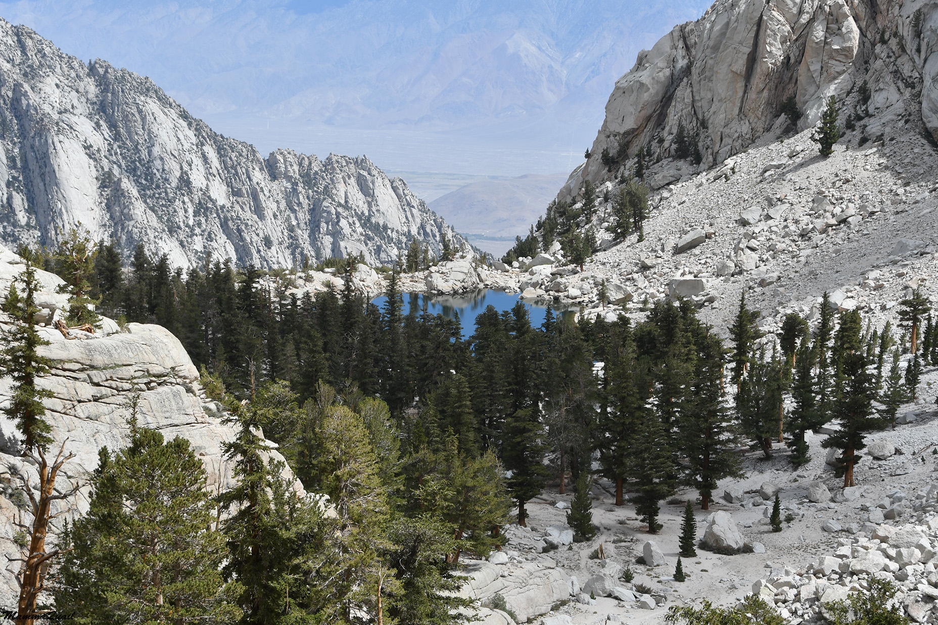 |
| Lone Pine Lake |
The way down that rock ledge was quicker than I anticipated. My crisis was over and although the pain in my feet was still there I was able to walk down faster. I think it was also because there were much fewer mule-size rock stairs to descend through.
 |
| Alpine Chipmunk |
Before reaching the lake I passed the sign that marked my exiting the Mount Whitney Zone. Below that sign a wilderness permit wasn't required for hiking. Indeed, there were many more people from that place and there on.

On one of my first visits to the town of Lone Pine I saw a photo of Lone Pine Lake for sale in an outfitters store, taken by the store owner. I was entranced by the lake's beauty and I purchased the photo and hanged it on the wall in my dining room. Ever since I wanted to see Lone Pine Lake in person but each time I was in the area I had to forgo the idea for various reasons. It had to be at the end of a big backpacking trip and across the tallest mountain in the contiguous US that I would finally see Lone Pine Lake in person and touch its calm water. Although I knew it'll add more time and also some distance to this day's hike (the access trail to the lake is a spur going in and out from the main trail) I simply couldn't pass on the chance to get to the lake. I didn't know when I will have another opportunity. I stayed near Lone Pine Lake for about half an hour, which was as long as I could allow myself. It was challenging to take a photo of just the lake because there were quite a few other people there. This photo and the one that heads this blogpost, I took just before a couple with their dog jumped into the lake and stirred the calm surface, disturbing the perfect reflection.
 |
| Lone Pine Lake |
The trail to the lake goes down a bit below the main trail, meaning I had to walk uphill again with my load, which now included also a bottle full of filtered water from Lone Pine Lake. Going up was easier on my sore feet though.
 |
| Mount Whitney Trail, East |
I crossed lone Pine Creek yet again, the last time crossing its south fork. Here it was much wider and the crossing was on a set of long, narrow planks that were laid across the water and the adjacent wet and muddy area. I had to wait for a large group of day hikers to come across before I could cross my self to the other side.
 |
| Lone Pine Creek |
On the other side I came upon a large field of lupine plants. They were all past their bloom and gone to seed. That field must have looked gorgeous when in peak bloom but now the plants were already wilting. Among them I found a single plant that had a single inflorescence blooming still.
 |
| Lupine, Lupinus sp. |
Soon after I left the lake I reached the edge of the last trail drop. Before me was the last section of switchbacks, and the longest for today. In length and in elevation change it was equivalent to the descent from the Mount Whitney crest that had claimed all of my energies the day before. The slope wasn't as steep though, and the trail itself was much easier to walk on, with only and occasional rock stair to necessitate leaning on my hiking poles. Still, it looked,and certainly felt, endless.
 |
| View down Lone Pine Ravine |
From there I had a great view of the western slopes of the Inyo Range, east of Owens valley. I think that the light line going uphill is the road to the ghost town of Cerro Gordo.

The way down the longest stretch of switchbacks may have seemed endless, but the sights along the trail were magnificent. I noticed again the change in vegetation as I dropped lower in elevation.

Another thing that was happening while I was walking down was that the clouds gathered over the high area that I left behind me and it looked like a storm was brewing there. Then the rain begun. Where I was the rain was just a light drizzle that didn't last very long. I didn't even feel the need to hide my camera. I thought about the hikers and backpackers up on the higher parts of the mountain and wondered how strong was the rain over there. The summit of Mount Whitney is a dangerous place to be if lightning happens. I didn't hear any thunder though.
 |
| Gathering Storm |
The rain didn't last long and the clouds soon were breaking off. I walked down slowly but without stopping. I planned one more stop at the crossing of the north fork Lone Pine Creek. I did pause to look at the flowers though, as I always do on hikes.
 |
| Scarlet Gilia, Ipomopsis aggregata |
Soon the sun was shining on me again. Clouds continued to drift overhead occasionally shading the trail but it didn't rain anymore on the rest of my hike.

Feeling tired I sat down a bit sooner than I planned. There was a switchback corner with e perfectly situated rock to sit on and a grand view of Alabama Hills just below.
 |
| Alabama Hills View |
Shortly after I moved on I passed a sign that marked the boundary of the john Muir Wilderness.Soon after that I came to the North Fork Lone Pine Creek Crossing. There's a backpacking trail that goes up that creek fork too but the trail looked very little used. It must be the perfect place to find solitude in an area that is otherwise so popular that it requires a quota limit.

Past the north fork crossing the vegetation changed yet again. Now dry-tolerating plants were becoming more and more dominant, and I started seeing beavertail cacti here and there by the trail side.

The trees were much thicker and taller here. For a long time now there were no foxtail pines, but conifers of other species. The slope didn't look as steep now and between the trees I could see some movement of shiny objects ...

... that were cars. I was looking down directly at the Whitney Portal area. I sighed, because there was still a mile of downhill to go and my feet and legs were already protesting loudly.
 |
| View on Whitney Portal |
I tried focusing on the pretty plants along the trail. It also helped that the trail grade was much more level now, even though it meant that it increased the length I'd have to walk.

I crossed another creek on the way down - the Carillon Creek. There was a trail going up that creek too, and I wonder if I ever get he chance to check it out. Not likely, but who knows?

Down and down I went on what seemed to be an endless trail, although on my map it showed that I had much less than a mile now. Now there were Manzanita bushes near the trail, and little junipers too. It was starting to look like near desert to desert vegetation.

I was now seeing wildflowers that I didn't see before on any part of this trip, having stated it higher than 10,000 ft. \i was definitely getting into the more desert community of plants.
 |
| Hoary Aster, Dieteria canescens |
It was nice to see that in this area the bloom did seemed to be at its peak, or not much past it. There would be time still before fall arrived to the lower elevations.
 |
| Buckwheat, Eriogonum sp. |
The Ceanothus was supposed to be done blooming at the time I was there, but I did get to see some bushes in bloom and to smell their sweet fragrance.
 |
| Desert Ceanothus, Ceanothus greggii |
Before taking the last turn on the final switchback down I looked up at he mountain peaks again. It looked stormy again up the mountains and seeing it I was glad to have made the choice to summit yesterday and not hang on the west side for a day longer.

I turned the last trail corner before reaching the Whitney Portal with mixed feelings. I was glad that soon I'd be resting my feet but I was also sad to be exiting the wilderness, and to be leaving the mountains.

I was glad to have gone on this trip and proud of myself to have made all the goals I'd set for myself. It was harder than it should have been though. I wasn't as prepared as I should have been, and I went on it a very short time after yet another foot injury, one that still bothers me now, two and a half months after the incident. I've no doubt that going on this trip has delayed my healing, quite possibly likely worsened injury. Had I cancelled it though, I don't know when I'd have had the chance to go there next. All and all, I'm glad I went, and I was glad then too, when I finally finished my hike.
 |
| Green Rabbitbrush, Chrysothamnus viscidiflorus |
The first thing I did when I reached the Whitney Portal was to dispose of my wag bag. Then I went into the store there and bought myself a shirt with an "I summited Mount Whitney" print, which I only wore once since. I also bought a side order of French fries that turned to be a huge plate with a mountain of fries that I couldn't finish even half of. After I wasted enough time at the Whitney Portal it was time to figure out how to get back to the town of Lone Pine. There was no reception there so I couldn't call the shuttle. I moved to the end of the parking area and I sat there, readying my thumb. Not too long after I was picked up by a nice backpacker who, as it turned out, just finished a backpacking route very similar to the one I did, only in merely three days rather than six. He was kind and took me all the way to where I had parked by the Film History Museum, where I changed to sandals, texted Pappa Quail that I was on my way, and started the long drive home.
 |
| The End |
That was quite a journey... I'm proud of you and just a little envy...
ReplyDeleteYou're welcome to join me any time!
Delete