

Date: March 16, 2025
Place: Henry W. Coe State Park, Morgan Hill, California
Coordinates (of Kelly Lake): 37.121952, -121.428315
Length: 9.4 miles
Level: strenuous
The second night of our Henry W Coe backpacking trip last March was noisy too - the night choir of frogs and birds was as loud as the previous night. This didn't hurt my sleep though. What did was the hip pain I had. The hip didn't bother me at all while I was walking, but lying down was really painful. The thin sleeping pad had probably a lot to do with it, but I suspect that the sub-freezing temperature had some contribution as well. It certainly colder than the previous night. The birds didn't seem to be affected by the chill though. The red-winged blackbirds started their choir of shrill trills before dawn hour.
 |
| Red-winged Blackbird |
I was first out of the tent this morning too, and I quickly reported to my friend that there was frost everywhere, meaning the temperatures dropped at night below freezing. I quickly checked my water bottle which was outside of the tent. The bottle was full of a 100% liquid water - it was a cold night but not as cold as that night when I backpacked at the Coso Range in December 2020. Then my water bottle was frozen solid, even though it was inside my tend.
 |
| Frost |
The frost didn't affect the duck that kept calling all night. In the morning I spotted the noisy bird as he swam across Kelly Lake, shouting still.
 |
| Mallard, male |
When I checked the folding bucket that we filled with water for washing I saw that it was covered with a thick layer of ice. Washing my hands was a bit painful, and for the time being I avoided washing my face.
 |
| Dawn at Kelly Lake |
My friend also got out of the tent and while we were preparing and eating breakfast we enjoyed the morning ensemble of the nearby songbirds, which now included also western bluebirds.
 |
| Western Bluebird |
Another bird that I noticed there that morning was a single swallow that did its aerobatics over the lake. I took many shots of that fast flier but very few of them were clear enough to identify its species.
 |
| Violet-green Swallow |
This was the third and last day of our trip. After breakfast we broke camp and quickly folded and packed everything. We shook the tent as much as we could but is was wet still when my friend packed it. We managed to clear the campsite about half an hour earlier than the time we left it for Pacheco Falls on the day before.

My friend had planned our route for us. She selected a round about trail that would go around Kelly Lake and up the eastern crest, then back to the valley and over the western crest of where Kelly Lake was. This route was longer than the one we came in on, but there was no repetition of trails, and, what was more important, the way downhill would be less steep and easier on our joints. We started south on Kelly Lake Trail and almost immediately found our amphibian of the day - a solitary newt that was crossing the trail.
 |
| California Newt |
The sun was up already by the shaded areas still had a thin layer of ice frosted on the plants. Little by little, as we progressed, the ice melted into tiny droplets that hung on the vegetation, giving them a bejeweled appearance.
 |
| Frosted Mushroom |
Following this trail we finally got to see the southern end of Kelly Lake. There were coots there, and mallards too. For some reason the birds on that side of the lake were quiet.
 |
| Kelly Lake |
Past the south tip of Kelly Lake we arrived at a trail junction and stood there for a while trying to figure it out - the junction was of Kelly Lake Trail, which was the one we planned on taking, and Kelly Creek Trail, which was not labeled on our maps, not even on the brochure that my friend picked up at the park's entrance. It looked as if the Kelley Creek Trail might be connecting with Wagon Road directly, what would shorten our route and make it easier.
 |
| Kelly Creek |
However, because there was no mention on the sign where was that trail
leading too and neither our maps nor my navigator had this trail marked
we decided to not take the risk. We turned on Kelly Lake Trail was went
uphill very steeply, to the east.
 |
| Kelly Lake Trail |
The frost was already gone and although we kept a relatively slow pace, we warmed up quickly as we ascended Kelly Lake Trail. There were also lots of wildflowers blooming near the trail.
 |
| Hound's Tongue, Adelinia grandis |
Nearly all of these wildflowers I've already seen on the first two days of the trip but I was happy seeing more of them on our way back as well.
 |
| Foothill Desert Parsley, Lomatium utricuatum |
The view opened up as we gained more altitude. The topography of Henry W Coe State Park is quite rugged with deep gulches and high, weathered ridges. My friend shared with me that when she looked up the trail possibilities for our trip she read some backpacker's comment that people to trips in the Sierra Nevada mountains to get in shape to backpack at Henry Coe ... I found that amusing but it certainly felt right when we pushed up a steep straight uphill trail without any switchbacks to ease up the grade.

By the time we were ascending Kelly Lake Trail the frost was already gone and evaporated from the plant leaves. Its last remains were caught in spider webs, like a delicate lace.

Yesterday my friend pointed out that we weren't seeing any young oak trees in the oak savanna we walked through. She speculated that it might be the effect of drought or global warming. I added a speculation that it might be the effects of past cattle grazing. We didn't know when grazing had ceased in this park. Anyhow, when I spotted a baby oak tree I pointed it out to my friend and we both wished it good luck and success in establishing itself and growing to be a mature tree.
 |
| Oak, Quercus sp. |
Up and up we ascended, on a seemingly endless slope. The wind picked up and when we reached the higher part of the trail it was powerful, and quite cold.

The view opened up. Looking back to the west we saw the oak-forested ridges, rounded by the rains and the wind. My friend pointed at the ridge that we would need to cross later that day to get to the Hunting Hollow entrance.
 |
| View West |
The mountains looked very different on the southeast - they were rugged and pointy, like teeth. The air was misty and the view blurred but the mountains appeared also more bare, less forested. I thought I could recognize the peak south of Pacheco Pass.
 |
| View Southeast |
There were woodpecker sounds from a tree nearby and soon I spotted one - he was perched atop one dead tree that was holed and probably used as their acorn granary.
 |
| Acorn Woodpecker |
The way up Kelly Lake Trail was steep and tiring. We wanted to have a short rest stop at the top of the trail but when we reached the Crest Road trail junction the wind was so intense that we decided to keep going, hoping to find a more sheltered place to sit at. The view was quite spectacular though, and we could finally see the entire of Coit Lake on the north, far down below.
 |
| Coit Lake view |
On the crest near the trail was a weather station that included a solid structure. We went up to the station and sat down beneath the lee side which provided some shelter from the wind.
 |
| Weather Station |
We snacked and chatted, and then my friend noticed a deer that was crossing the trail. It was the first deer we saw on this trip. The deer walked slowly, pausing every now and then to look at us. Then it continued down the slope and disappeared behind the oak trees.
 |
| White-tailed Deer |
Meanwhile a male bluebird flew near and settled on the wires that extended from the weather station and where anchored in the ground. The bluebird also looked at us, and I wasn't sure if he wanted food or wanted us to go away. Assuming not many people frequent the weather station, I suspect it was the latter.
 |
| Western Bluebird, male |
Lovely yellow flowers dotted the green grass between the oak trees. Most of the yellow flowers were the common California buttercups. The buttercups were at their peak bloom.
 |
| California Buttercup, Ranunculus californicus |
Here and there I spotted also California goldfields among the yellow blossoms. The goldfields were just beginning their bloom season. Before long they'll form large yellow patches on the hillside.
 |
| California Goldfields, Lasthenia californica |
The Crest Road leg was very short. Soon we reached the junction with Wagon Road, which we planned to take back westward. The stretch of Wagon Road that we were going on was mostly a mild downhill grade, and was nice and easy to walk.
 |
| Wagon Road |
For the most part we were hiking through oak savanna. In many places the oaks, which at this height were deciduous and still mostly winter-bare, were closer together, their naked boughs touching one another. To me they looked like a troupe of wild dancers.

Many of the flowering plants I've seen blooming along Wagon Road I've seen already in the previous days of this trip. There was a large variety of shapes and colors, and I greatly enjoyed the early spring display.
 |
| Fuchsiaflower Gooseberry, Ribes speciosum |
Whenever the trail was in the open we were treated to the gorgeous view of the coastal range wilderness. The air clarity wasn't good though - there was still much moisture in the air and thin, foggy clouds veiled the horizons.

Every time we passed a trail junction my friend would stop and check her map printouts. She knew which one we needed to take but it was good to confirm our location each time. When we reached the junction with the trail leading to the Dowdy Ranch Entrance on the south eastern side of the park she pointed it out to me. Should I ever want to come to Pacheco Falls on a day hike (a very long and intense day hike it would be!) the Dowdy Ranch entrance is where I'd chose to start.
 |
| Wagon Road |
Having seen the falls at their best, I didn't feel compelled to up the physical price of seeing them again. We continued walking and I continued looking for more wildflowers, even seeing some I haven't yet seen on this trip.
 |
| Narrow-leaved Owl's Clover, Castilleja attenuata |
In the same part of the trail I spotted another species of owl's clover. There were a bunch of them near the trail that had just started blooming. I found one of them that had already opened some flowers.
 |
| Dense-flowered Owl's Clover, Castilleja densiflora |
The route that my friend planned for today had us go near a pond called Tule Pond. When we saw a pond way down below was stopped and checked the map. No, this wasn't Tule Pond, just another on of them ponds built in the area to water the cattle during the ranch time of this place.

The silver bush lupines were nearing their peak bloom at the time. There were many of these silvery, furry leaved plants around and their blossom candles lit the green grass in beautiful purplish blue.
 |
| Silvery Bush Lupine, Lupinus albifrons |
The Wagon Road stretch was the longest leg we had on our today's route. Slightly over two miles we undulated up and down (but mostly down) and the crest of the ridge. Sometimes we were fully in the open and had great, sweeping views. Other times we were walking through an avenue of oak trees with the occasional Coulter pine in between.
 |
| Wagon Road |
We walked at a good pace. Not too fast, but also not sluggishly slow. On the occasions I paused to look at wildflowers I had no trouble catching up with my friend after that, she didn't need to wait for me.
 |
| Indian Paintbrush, Castilleja affinis |
One of the spots Where I caught up with my friend she stood by a trail junction sign and looked at it with mild annoyance. That sign marked the junction with the Kelly Creek Trail, the very same we had our dilemma about earlier that morning. Had we taken this trail our route would have been significantly shorter. The problem was that this trail wasn't marked on any of our maps. There wasn't much to do about it now, but make a note for next time, whenever that may be. We quickly turned our attention to more beautiful things, such as the only larkspur that I saw blooming on that trip, which bloomed right next to that trail sign.
 |
| Royal Larkspur, Delphinium variegatum |
Delicate saxifrage flowers bloomed in the more shaded spots, places that normally retained more moisture. My friend pointed out that we weren't seeing any runoff water on the trails now, two days after the rain, and that we should fill up on water when we stop for lunch at Wasno Lake.
 |
| California saxifrage, Micranthes californica |
Wasno Lake was one of the human-created ponds, made by raising an earth dam to collect creek water. We reached the lake in time for an early lunch and a well-earned break.

Taking the time to filter water and eat a good lunch I also scanned the pond for waterfowl and found a solitary male bufflehead duck. The drake was at the far end of the lake and barely visible to the naked eye.
 |
| Bufflehead Duck, male |
There were plenty of wildflowers too where we sat for our break, including numerous baby blue eye flowers. We've seen many of them throughout the entire trip but I wasn't getting tired of seeing more of them.
 |
| Menzie's Baby Blue Eyes, Nemophila menziesii |
After a good, long lunch break it was time to move on. Wasno Lake was located right at the junction of Wagon Road and Wasno Road. We needed to take Wasno Road now, to get to the Tule Pond Trail we wanted to descend on.
 |
| Wasno Lake |
Taking Wasno Road meant going uphill again, although not steeply and not for a long distance. Once again we heaved our backpacks and started plodding uphill.
 |
| Wasno Road |
On the short stretch we hiked up Wasno Road we got to see a scrub jay with her choice of nesting materials perched atop a laurel tree.
 |
| California Scrub Jay |
My friend, who knew my passion, pointed out little dark pink flowers in the grass - a small clamp of lovely red maids.
 |
| Red Maids, Calandrinia menziesii |
She also found some star moss on the slope beside the trail. The immediate area where the moss grew was already dry, but I figured there was enough moisture retention there for the moss to grow well.
 |
| Star Moss |
We reached Tule Pond Trail, which was a narrow foot trail descending straight down into the deep gulch below.

I followed my friend down the trail, trying to not think about having to hike up every foot that we were now descending. Instead, I focused on the lovely wildflowers that bloomed near the trail.
 |
| Bird's Eye Gilia, Gilia tricolor |
Near that trail was the first time on our trip that we finally got to see the California poppies fully open. I guess the weather was finally agreeable to them, despite the chilly wind.
 |
| California Poppy, Eschscholzia californica |
The wind also blew waves in the wild oats that dominated the open grass areas between the oats. Wild oats is a highly invasive species here, but the sight of those rolling silvery waves was truly lovely.

Naturally our views diminished as we descended quickly into the gulch. It might have been easier to take the milder-graded Wasno Road down, but the foot trail wasn't too bad and it was considerably shorter, too.

The Tule Pond Trail was part of the route suggested at the park's brochure for getting in and out of Kelly Lake. The wildflowers blooming there definitely added points to taking that choice.
 |
| Padre's Shooting Star, Primula clevelandii |
Flowers weren't the only things blooming at the time. Every now and then we came upon mushrooms that looked very fresh and recently popped.

There was a lot to see along the Tule Pond Trail but none slowed us down,. Soon enough we reached the bottom of the gulch and within sight of the Tule Pond. It seemed that we were not to leave the park without seeing at least one more water cascade, even if little.
 |
| Tule Pond |
At the bottom of the valley we had to cross the little creek that poured out of Tule Pond. In the park's brochure it said that this was the last reliable water source until reaching Coyote Creek at the Hunting Hollow park entrance. My friend duly filled her water bottles. I passed on the opportunity because I was very much hydrated after lunch, and my bottle was almost still.

Past the creek we connected with the Grizzly Gulch Trail on which we were to go a very short distance before our next turn. This was at a part of that trail that we haven't been on on our first day when we ascended the Grizzly Gulch Trail. The trail was partially flooded, suggesting that runoff water was still a possibility up ahead.
 |
| Grizzly Gulch Trail |
We passed right by Tule Pond. I scanned the water surface but saw no waterfowl other than a pair of mallards who took off instantly and flew away.
 |
| Frog Lake |
We were already ascending that part of the Grizzly Gulch Trail when we came upon our turn on Serpentine Trail. We needed to go up Serpentine Trail all the way to the top of the ridge that stood between us and the park's exit.
 |
| Serpentine Road |
Throughout our trip my friend kept asking about the curly leaves that grew out of rock cracks on the trails. I didn't remember what these were but eventually it did come to me after seeing some of the old fibers protruding below the green leaves. This was the soap plant, used extensively by the Native Californians for their saponins and their fiber.
 |
| Wavyleaf Soap Plant, Chlorogalum pomeridianum |
The clouds were slowly gathering and as we ascended the sky darkened a few shades. A few patches of Johnnytuck flowers color to the graying day.
 |
| Johnnytuck, Triphysaria eriatha |
My friend paused near a very disturbed patch of land under the oak trees. The turned up soil was the work of wild boar - wild pigs that were brought over as hunting game and successfully established themselves in the Bay Area. These pigs now cause serious ecological damage in local parks.
 |
| Pigs Diggings |
In areas that remained undisturbed bloomed many violets. Their flowers were the largest I've seen yet - they must have been very happy growing on this slope.
 |
| California Golden Violet, Viola pedunculata |
In other places in the East Bay the California Laurel was already done blooming. Here at the heights of Henry Coe State Park the laurel trees were a bit behind, so I was treated to their nice, fragrant blossom.
 |
| California Bay, Umbellularia californica |
A dead oak tree loomed ahead up the trail. The tree was full of woodpecker holes and my friend stopped there to admire the birds' work.

She'd never seen these acorn granaries so full before, she told me. The tree was indeed quite full - nearly all the holes had acorns stuck in them.

Finally, after a fairly slow ascend we could see the crest of the ridge we were climbing. The wind was blowing stronger yet so we didn't even consider a rest stop. We weren't quite at our next trail junction though.

Many of the oak trees we've seen are laden with heavy balls of mistletoe. The mistletoe-ridden trees, bare of leaves still, looked like strange hangers for even stranger ornaments.
 |
| Mistletoe-covered oak |
At the ridge the grass was stunted. I saw small patches of California goldfields which too, looked stunted.
 |
| California Goldfields, Lasthenia california |
Right at the trail junction with the Steer Ridge Road I saw a lovely patch of cream cup flowers. I remembered cream cups from Carrizo Plain and I was very much surprised to see them here, at Henry Coe Park.
 |
| Cream Cup, Platystemon californicum |
Thin lines of short grass separated large patches of bare soil and rocks. The grass looked very different than all the other grasses I've seen up until then, which were mostly invasive species.

The exposed soil was greenish-gray in color and it looked like the plants were actively avoiding it. This soil, I later learned, was serpentine soil, formed from serpentinite rocks. I suppose that the name of Serpentine Trail on which we got there should have been enough of a hint as to the identity of this soil but the identification actually came from members of the California Geology Forum. Serpentinite is California's state rock. It is poor in essential minerals and most plants can't grow well or at all on serpentinite soil. Vegetation that does grow on it are specialized to it and form unique plant communities.

The Steer Ridge Road was cutting right through the layer of serpentinite. We turned right and commenced walking on it due north.
 |
| Steer Ridge Road |
From Steer Ridge Road we had nice views all around, and no shelter from the blasting wind. The chill helped me to keep my pace up.

I still paused for wildflowers, but most time it was just for a quick photo and then I'd move on. I didn't wand to break the pace on top of the ridge.
 |
| Lacy Parsnip, Lomatium dasycarpum |
The trail undulated up and down and meandered around the bumps that made the peaks of the ridge. There was no more serpentinite anywhere to be seen. The earth was reddish here, and looked very rich and fertile.

We were seeing more and more of the view to the west, all the way down to the valley. At my highest magnification I could discern the bright roofs of a town - if to judge by the direction I'd say that was Gilroy, the garlic capital of the world.
 |
| Gilroy |
We passed a number of trail junctions. Each f these trails would have taken us down to either the Coyote Entrance or the Hunting Hollow Entrance. They were all shorter but they were also steeper. My friend had selected the route recommended on the park's brochure as the prettiest and the mildest in grade. My joints would prefer that too.
 |
| View north from Steer Ridge Rd |
Wherever the trail curved around a hill rather than on it there would be a different variety of wildflowers blooming. The change in slope made a big difference in the growth conditions, it formed a different niche.
 |
| Pacific Pea, Lathyrus vestitus |
The clouds kept rolling in but they didn't stay and pile up. Every now and then we were treated to a piece of sunshine and a tiny patch of blue sky. The contrast gave the ridge line a somewhat eerie look. The wind kept blowing, giving it the fitting feel too.

The hike on Steer Ridge Road seemed to be going on forever. By that time both f us were eager for a break to eat and rest a little. When we finally came to the junction with the Jim Donnelly Trail,, the trail we had planned to take downhill, we had an opportunity. Right at the junction was a large live oak tree and below it - a picnic bench. We hurried down to the bench and gladly took off our packs and sat down to eat.

That well deserved break at the trail junction was our last. We discussed how much food was the right amount too take on a backpacking trip. I had finished all of my food during that break. My friend thought that taking extra would be prudent, in case of getting stuck out in the wilderness. She was correct of course, and I usually do take some extra when I backpack in more isolated places.

All too soon it was time to get up and get going. Jim Donnelly Trail was a narrow foot path, and its description was accurate - its slope was mild and the scenery was very pretty. The poppies however, were already closing down for the day.
 |
| Jim Donnelly Trail |
Below us was a little cattle pond. The water looked very muddy and murky but I figured that in an emergency I could have filtered (and possibly also boiled) that water. As it was, I still had enough in my bottle. Besides, It wasn't a hot day and I knew that the Hunting Hollow parking lot wasn't all that far.
 |
| Pond |
We started going in and out of small groves of trees. Under the trees bloomed wildflowers different of those that we've seen in open areas. I liked that diversity.
 |
| Milkmaids, Cardamine californica |
I was used to taking photos on the move but I still paused at times, then having to catch up with my friend who was at the lead.
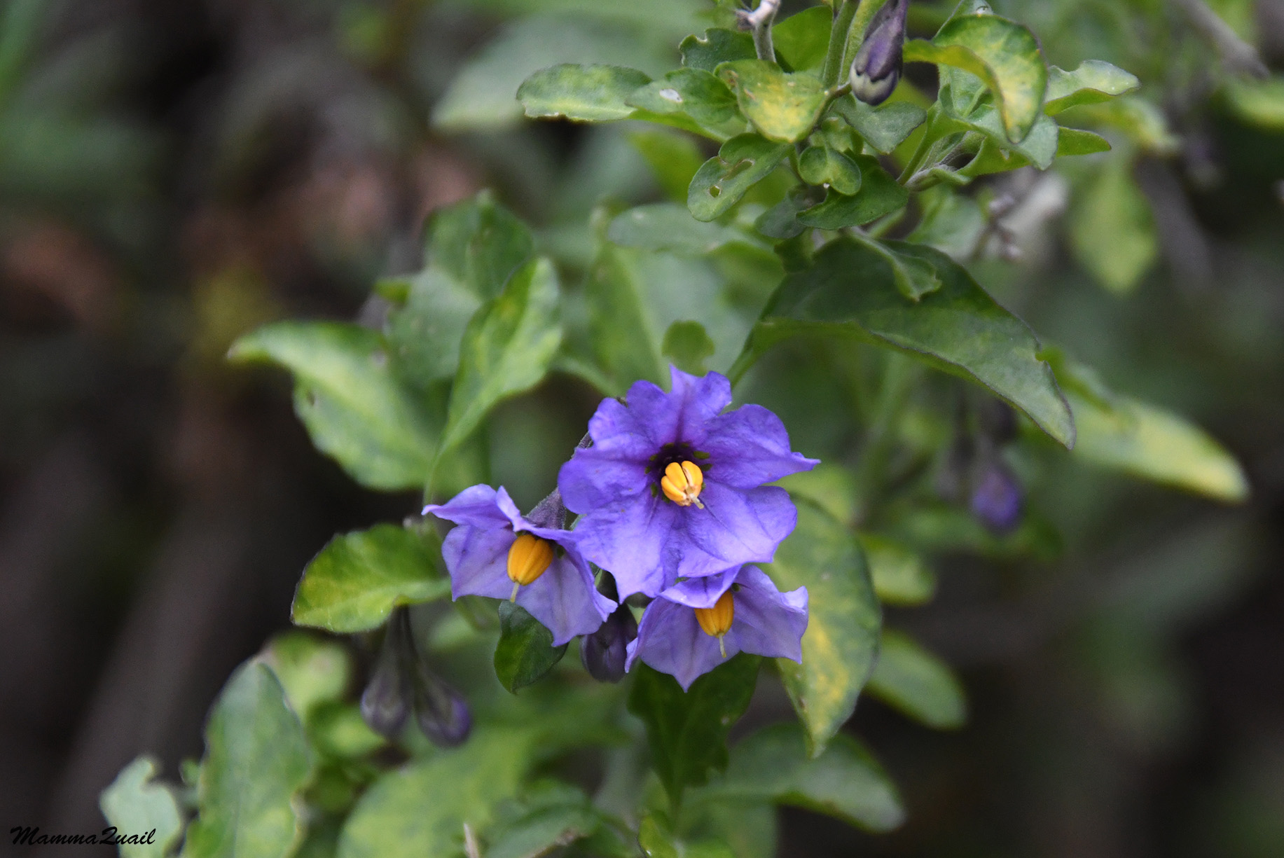 |
| Blue Witch Nightshade, Solanum umbelliferum |
Since our descend at Tule Pond Trail we've been encountering bikers on the trails. All of them were riding electric-assisted bikes, which I thought was weird. A few more of them were now coming up the Jim Donnelly Trail.
 |
| Blue-eyed Grass, Sisyrinchium bellum |
It was getting late in the afternoon by now and we wondered if the bikers will be fast enough to get out of the park before nightfall. Perhaps that was why they've used the electric assist engine.
 |
| Rusty Popcornflower, Plagiobothrys nothofulvus |
We spotted a covey of quails far below us by south of the trail. Even with my strongest magnification I could get only small images. At least they didn't fly into hiding right away.
 |
| California Quail |
Eventually the quails did vanish into the bushes and we moved on, I started getting weary but had a long way down still.
 |
| Purple Sanicle, Sanicula bipinnatfida |
Most of the deciduous oaks that we've seen on this trip were bare still at the time, but every now and then we came across one that was farther along than its neighbors.

My friend noticed a red spot on one of the thinner branches of the oak and called me over - this was a developing gall that had just begun swelling out of the branch.

The lower we descended though, the oaks shifted from the deciduous species to the evergreen live oaks. Dark, moss-covered boughs arched over the trail, blocking more of the sunlight that had filtered in through the clouds.
 |
| Jim Donnelly Trail |
Next to the live oaks flourished also the poison oak, although thankfully not too close to the trail itself. The poison oak too was blooming.
 |
| Poison Oak, Toxicodendron diversilobum |
Blue dicks were more numerous along this stretch of the trail. Their tall stalks towered over the grass. My friend said they were taller here than those we've seen closer to Kelly Lake.
 |
| Blue Dicks, Dipterostemon capitatus |
In open areas we had nice view down into the valley. Below us to the southeast we could see the valley that extended from Hunting Hollow.

There was a long patch of nice, green lawn there, and my friend said it looked like a golf course. It wasn't very likely that it was a golf course but I did get curious about what that bit of lawn was. I still don't know.

We passed yet another small cattle pond. This one was for sure unmaintained.The earthen dam was breached and plants grew inside the depression behind it. I wondered if any of these little cattle ponds that littered the park was maintained, now that there was no more grazing in the area.
 |
| Cattle Pond |
The trade off of the mild slope of the Jim Donnelly Trail was that it was quite long. We were eager to finish the hike soon - my friend still had a long drive ahead of her, and the trail seemed to be going on forever. Eventually though, we did come to the junction with the Middle Steer Ridge Trail on which we'd descend a short distance down to the valley floor.
 |
| Middle Steer Ridge Trail |
Indeed, before long we could see the Hunting Hollow parking area. I could see that there were quite a few other cars parked there, including two horse trailers. The parking lot was still far below.

Even this late into the trip I was seeing new wildflowers. These clovers must have been ready to bloom when we begun our trip and bloomed right after the rain stopped.
 |
| Variegated Clover, Trifolium variegatum |
I nearly bumped into my friend when she stopped and raised her camera - there was a deer ahead of us. We waited patiently until the deer moved higher up the slope.
 |
| White-tailed Deer |
The last bit of downhill trail we walked so fast it was almost a run. MI hardly paused anymore near the wildflowers. It was getting more dark and it looked like it might rain again soon.
 |
| Middle Steer Ridge Trail |
But then again, right at the next and last trail junction of our trip were a few other deer. All and all we've seen deer three times on our trip, and all of them on our last day.
 |
| White-tailed Deer |
The last bit of trail was a flat, less than half a mile dirt road. The sky was definitely getting darker, and not only because it was getting late. The clouds were gathering again.
 |
| Lyman Willson Ridge Trail |
There was one last obstacle on our way. Just before the parking lot we had to cross Coyote Creek. Thankfully it was relatively wide and shallow at the trail crossing, and we found a line of strategically placed stones that we could balance on.
 |
| Coyote Creek |
It was almost 6 pm when we reached the car and took off our packs. We had finished three full days of a very lovely backpacking trip in the wilderness of Henry W. Coe State Park, a beautiful local nature gem. In less than a month I'd be back there for day hikes and everything woud be blooming without any sign of rain.
This was a very long hike... but full of nice flowers and views
ReplyDeleteThe longer way spared our old and aching joints ... and we got to see some very interesting sights too!
Delete