
 |
| Coyote Creek |
Date: April 9, 2025
Place: Henry W. Coe State Park, Morgan Hill, California
Coordinates: 37.186671, -121.546825
Length: 10.7 miles
Level: strenuous
Last March I went with a friend on a three day backpacking trip in Henry W. Coe State Park, a trip which left me craving for more. On the following month I went on a day hike there, and a friend joined me. I wanted that hike to be a preparation for a family group hike that I was planning to lead later that month. The original trail was only 3 miles long but my companion wanted a longer hike so we ended up hiking the entire Madrone Soda Springs - China Hole - Poverty Flat loop, which is a nearly 11 miles, strenuous hike.
 |
| Our hike as captured by my GPS |
The first part of the hike on Corral Trail overlapped with the trail I wanted to take the family group on. I've walked there many times, and even posted it here before. I promised myself that I won't delay to take a million phots. I kept my promise for about a hundred yards - there were just too many beautiful flowers there!
 |
| California Golden Violet, Viola pedunculata |
California buttercups start their bloom season pretty early in spring. I've seen plenty of buttercups on my March backpacking trip. It was nice to see them blooming well into April as well.
 |
| California Buttercup, Ranunculus californicus |
The Corral Trail merged with Manzanita Point Road but we continued east on Springs Trail. We couldn't have asked for a better weather - it was clear and sunny, but also nice and cool air.
 |
| Springs Trail |
Out in the open bloomed the grassland wildflowers. The ookow flowers were nearing their peak bloom - we saw many of them along the hike.
 |
| Ookow, Dichelostemma congestum |
The California poppies were at their peak bloom. This wasn't a super bloom year but the poppies put out a nice display nonetheless. The most visible poppy patches were along Manzanita Point Road, and I expected seeing them on our way back, but we could see the edge of that bloom from Springs Trail below.
 |
| Poppy Patch |
The poppies were large enough and orange enough to be seen above and between the grasses. Other, smaller wildflowers, such as the miniature lupine, were visible only from a close distance.
 |
| Miniature Lupine, Lupinus bicolor |
Western blue-eyed grass was more visible - these plants grew in clamps and bloomed together, forming nice little patches of purplish-blue.
 |
| Western Blue-eyed Grass, Sisyrinchium bellum |
Another early bloomer that continued flowering well into April was the miner's lettuce. I couldn't resist nibbling on them a little bit.
 |
| Miner's Lettuce, Claytonia perfoliata |
It didn't take long for my hiking companion to open a gap - I kept pausing to look at the wildflowers, and there were many of them.
 |
| Springs Trail |
I came to Coe Park expecting to see patches of poppies but the biggest floral carpets this spring were of the California violet. The entire hillside was covered with them. They're small and yellow and may not make as big an impression as our state flower but they were enough for me to forget this was a super bloom skip year.

There were other patches of wildflowers, of different colors. The purple owl's clover formed little dark pink patches in the grass that were easier to see than the yellow California violets, although they weren't as prevalent.
 |
| Purple Owl's Clover, Castilleja exerta |
If looked for the ground iris in a forested patch that we crossed earlier on the trail, where I've seen them bloom in previous years. When I didn't see them there I wondered if they too skipped a year. I was glad to find out that not so. The ground iris was at peak bloom and the flowers were gorgeous. We've seen a few more of them in other spots along the trail.
 |
| Ground Iris, Iris macrosiphon |
In March the deciduous oaks were just beginning to bud out. Now they
were all covered with bright green, freshly grown spring foliage. The
the evergreen live oaks were darker, but they too sported new grown
leaves.

Eventually the Springs Trail merged with Manzanita Point Road, a wide packed dirt road that runs from the Coe Ranch entrance to Manzanita Point campground area. We turned right on Manzanita Point Road and continued walking southeast.
 |
| Manzanita Point Road |
We diverted from the trail to check out Bass Pond, where I had planned to have the rest stop for my family hiking group. At the time there were no other humans near the pond.
 |
| Bass Pond |
 |
| Tadpoles of Western Toad |
There were also some fish in the water. I know that people do come to fish in this pond, but I couldn't tell whether these fish were bass.
 |
| Fish |
We didn't stay for too long near the pond. I've seen what I needed to see there, and so we moved onward.
 |
| Manzanita Point Road |
It was my companion that pointed out the baby blue eyes that were blooming along the trail. They were just beginning to bloom when I saw them during my March trip but now they were at their peak. We saw many, many of them on that hike.
 |
| Menzies' Baby Blue Eyes, Nemophila menziesii |
My companion was also the one who first saw the turkey tom that roamed through the oak savanna a bit away from the trail. He seemed to be on his own and did not respond when I tried gobbling at him. Perhaps I got the dialect wrong.
 |
| Wild Turkey |
When we reached the junction with the Madrone Soda Spring Trail, a thin foot path going down to Coyote Creek, I presented the choice of doing the loop clockwise. My companion however, wanted to go counter clockwise, because that's how his app suggested. I didn't argue with him. We went down the Madrone Soda Spring Trail.
 |
| Madrone Soda Spring Trail |
We continued downhill through the oak savanna. The trail was narrow and meandered a lot. There were plenty of wildflowers to see all around. A few more ground iris, fiddlenecks, owl's clover and mats of little bird's eye gilia.
 |
| Common Fiddleneck, Amsinckia menziesii |
Many of these wildflowers grew right by the trail and I had a good opportunity of taking closeup photos. I didn't linger long though - my companion was darting ahead down to the creek.
 |
| Purple Owl's Clover, Castilleja exerta |
While most of the way down to the creek was through oak savanna, we did pass through an area of almost chaparral. This place featured grand manzanita bushes, tall enough to form a canopy over the trail, creating a short tunnel.
 |
| Madrone Soda Spring Trail |
The trail dips into Sycamore Canyon and reaches a tributary of Coyote Creek and the Madrone Soda Springs wilderness campsite. There were no other humans in that area. We stopped briefly to drink some water, then we turned left on the Mile Trail, going downstream along the creek towards China Hole.
 |
| Mile Trail |
That trail segment is named Mile Trail but the name is misleading, for it is longer than a mile to get to China Hole. Not that I had any complaints - the trail was beautiful and featured many wildflowers that we haven't seen yet on the hike - they were shade-tolerant plants that preferred damper places near creeks.
 |
| Hillside Woodland Star, Lithophragma heterophyllum |
Butterflies were abound too, but it was the first time in this season that I've seen the orangetip butterfly. It sure was hyperactive and hard to get a focus on.
 |
| Sara Orangetip |
Mile Trail crosses the creek numerous times. There was a good, vigorous water flow but it wasn't too high for crossing on rocks paced across the stream. In one of these crossings we had a surprise - a California newt laid low on the rocky bottom of the creek. It didn't move even when we crossed.
 |
| California Newt |
That tributary of Coyote Creek runs sort of west-east, so each time we crossed we switched from walking on the north-facing to the south facing bank, and vice-versa. The north-facing slope was better forested and therefore better shaded. The forest's understory reflected that with shade-loving Plants such as ferns.
 |
| California Maidenhair Fern, Adiantum jordanii |
That part of the hike, on the north-facing side of the creek, was the only part of the hike where I've seen fresh, recently sprouted mushrooms.

Milkmaids was also among the early bloomer species that were going on blooming well into the second wave of spring bloom.
 |
| Milkmaids, Cardamine californica |
My most prized wildflower sighting of that hike was the giant wakerobin - the largest of the three Trillium species found in the Bay Area.
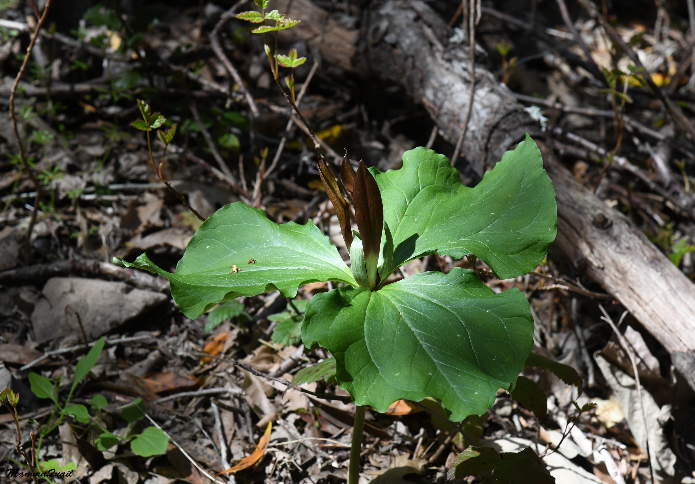 |
| Giant Wakerobin, Trillium chloropetalum |
At some point I stopped counting the times we crossed the creek, but there were definitely more than ten such crossing. It was a matter of zigzagging between the banks and shifting between shade and full sun. We didn't see any more newts though.

The south-facing slope on the north side of the creek had mats and mats of wildflowers. The flowers seemed to be grouped by color - patches that were dominated by one particular species. The yellow in the photo below was of buttercups.
 |
| Mile Trail |
We came upon a lilac-colored wildflower patch and I got excited - these were the flowers I was looking for and didn't see near Bass Pond.
 |
| Large-flowered Leptosiphon, Leptosiphon grandiflorus |
These were the large-flowered leptosiphon. My companion didn't share my excitement - these flowers are fairly small. I explained to him that the other species of leptosiphon were much smaller, but he still wasn't impressed.
 |
| Large-flowered Leptosiphon, Leptosiphon grandiflorus |
He did share my enthusiasm however, when I found a checker lily in bloom. These Fritillaria flowers don't bloom in patches and their variegated flowers are well camouflaged in a heterogenous background.
 |
| Checker Lily, Fritillaria affinis |
Eventually we made our last creek crossing (for this part of the trail) and settled on the north bank (the south-facing side) of the creek. It was also easier to avoid the poison oak now that the trail was somewhat wider.
 |
| Mile Trail |
A few hundred yards the tributary we were walking along merged with Coyote Creek. While the creek itself curved southward we continued north on the Mile Trail, now walking upstream Coyote Creek which was considerably wider.
 |
| Coyote Creek |
We were eager to get to China Hole now. Both of us were hungry and ready for a nice lunch break at China Hole. I wasn't in such a hurry that prevented me to stop for wildflowers, though.
 |
| Arroyo Lupine, Lupinus succulentus |
To the list of creek side plants I now added the manroot vine, a type of wild cucumber that is spiny and toxic to humans. Its flowers are very pretty, though.
 |
| California Manroot, Marah fabacea |
At last we reached China Hole and sat down near the water to have our lunch break. I had my little backpacking stove with me and I took the opportunity to make some tea for us to go along with our food.
 |
| China Hole |
China Hole is a gorgeous swimming hole, usually accessed by the China Hole Trail directly down from Manzanita Point Road. I've hiked numerous times to China Hole since my first hike there, nine years ago. We had a very relaxing lunch break near the water, but didn't go in for a dip.
 |
| China Hole |
After finishing our lunch we packed up and got ready to move on. I suggested perhaps going up the China Hole Trail but my companion insisted on hiking the entire loop that was laid out by the app and so we continued upstream along Coyote Creek toward Poverty Flat.

At some point the trail disappeared. It looked like it was continuing on the other side of the creek but we didn't see any obvious crossing. Moreover, my recollection from previous hikes I did there had the trail continuous on the west side of the creek, For a few moments we weren't sure what to do.
 |
| Coyote Creek |
Eventually we spotted a thin foot path that continued on the west side of the creek and so we continued on it. For some distance the hike was good but we soon we got concerned again because the path deteriorated. It was clear that it was not a maintained trail. Still, we were hoping to find the connection with Poverty Flat Trail, which we intended to go back up on. Meanwhile, I was enjoying the wildflowers.
 |
| Western Heart's Ease, Viola ocellata |
The shooting star flowers were already past their peak bloom. Most of them were well into making fruit, but I did find a few late bloomers that still looked in their prime.
 |
| Henderson's Shooting Star, Primula hendersonii |
I also found some nice saxifrage blossoms on the steep, damp slope below which we were straggling more and more to identify the walkable path.
 |
| California Saxifrage, Micranthes californica |
Two of the three violet species I saw that day were on this part of the hike, and none of them were violet color. My companion found it funny when I told him that most violet species in California were, in fact, yellow.
 |
| Goosefoot Violet, Viola purpurea |
By the time I've seen the violets the plant that was on my mind the most was the poison oak. By then it was clear to us that the path we chose to follow, which was the old trail that I remmembered, was no longer meant to be hiked. It had deteriorated into a thicket of vegetation, much of it was poison oak, and I could no longer avoid contact with this plant. Eventually, even bushwhacking through poison oak was no longer an option - the trail simply ended where the creek and the steep slope met. Apparently the original trail was washed away. We now had to cross Coyote Creek, pretty wide at that point, but thankfully also pretty shallow.
 |
| Coyote Creek |
We managed to cross Coyote Creek without water coming inside our shoes. On the other side we connected with Poverty Flat Road - a wide and comfortable packed dirt road.
 |
| Poverty Flat Road |
The ease of walking on Poverty Flat Road was short lived - we soon were back at bank of Coyote Creek, searching once more for a convenient place to cross it and return to the west side.
 |
| Coyote Creek Crossing |
After crossing Coyote Creek for the last time we stopped again for a short break. Not wanting to carry too much water I brought my filter instead of an extra bottle. Now I needed to filter water and refill my bottles before starting up the hill. Coming up on my feet I noticed a beautiful patch of tiny white flowers and I got closer to inspect.
 |
| Variable Linanthus, Leptosiphon parviflorus |
These tiny star-like flowers were variable linanthus, which is a species of leptosiphon. I showed them to my companion as a reference to why the other leptosiphon species that we saw earlier on the hike was named large-flowered.
 |
| Variable Linanthus, Leptosiphon parviflorus |
Nearby I also spotted a blooming paintbrush, the only one blooming that I've seen on the hike that day. It was just the very beginning of their bloom.
 |
| Coast Paintbrush, Castilleja affinis |
I wanted to go up Poverty Flat Road but my companion pointed at the open app on his phone which marked Poverty Flat Trail for the ascend. I didn't argue. We found the foot trail and started uphill.
 |
| Poverty Flat Trail |
We walked uphill quickly. The trail was going up a north-facing slope and we were surrounded by a tall, dense vegetation, which had was mostly thin oaks and tall shrubs. Manzanita bushes can grow really tall in such places. Their smooth, red bark always looks to me like a work of art.
 |
| Manzanita, Arctostaphylos sp. |
A bit before the junction with the China Hole Trail the vegetation changed into tall chaparral. The chaparral bushes were not as tall as the oaks and manzanitas but were much more dense. A human trying to go through chaparral would have to crawl close to the ground. Thankfully, we had a nice clear trail to walk on.
 |
| Poverty Flat Trail |
Poison oak is very common all around the Bay Area, and Henry W. Coe park is no exception. For the most part I did a good job of avoiding contact with this plant except for that bit of trail along Coyote Creek past China Hole. Despite being sensitive to the urushiol - the allergen that poison oak produces, i do admire this plant. It is very adaptive and can have many forms. It is also a keynote species - many animals depend on it for sustenance.
 |
| Pacific Poison Oak, Toxicodendron diversilobum |
The chamise bushes dominated the chaparral, and between them were other bushes which, although not as prevalent, attracted the eyes more. One such shrub was the Fuchsiaflower gooseberry, of which I'me seen many on my March backpacking trip to Coe Park.
 |
| Fuchsiaflower Gooseberry, Ribes speciosum |
A familiar scent filled the air, and soon I identified the source - buckbrush bushes in full bloom. I inhaled greedily the sweet fragrance of these beautiful ceanothus shrubs.
 |
| Buckbrush, Ceanothus cuneatus |
In a couple of places the chaparral was low enough to give us a nice view down to the valley of Coyote Creek. In fact we went a bit down China Hole Trail to a point where my companion's app said was a vista point. The view was the same - pretty, but not more so than what we've seen higher up the trail.

We clambered back up the trail and resumed our uphill stride toward Manzanita Point and Manzanita Point Road.
 |
| China Hole Trail |
Near Manzanita Point the chaparral gave way to the forest once again. At that point we were both pretty hot from the climb and we welcomed the shade.
 |
| China Hole Trail |
Below the first trees I spotted the one wildflower that I expected to see last March but didn't finsd any - the Indian warrior, or in its current name, Warrior's Plume. This plant is an early bloomer and I thought that not having seeing it on my March trip meant that I won't see it this season at all. Well, I was wrong about that, and I didn't mind it one bit.
 |
| Indian Warrior, Pedicularis densiflora |
The forest at Manzanita Point wasn't very dense. Plenty of sunlight percolated through the canopy and supported a nice and diverse understory growth. Butterflies hovered over the wildflowers and hanged around sunny spots even if there weren't any flowers there.
 |
| Anise Swallowtail |
We continued at a quick pace until we reached Manzanita Point Road. There we stopped for a short hydration break after which we continued northwest on the packed dirt road.
 |
| Manzanita Point Road |
We passed near Bass Pond but this time we didn't go near the water. At that point I was a bit pressed on time, too. We continued straight ahead.

I love seeing lonely oak trees. Without being space-restricted by neighboring trees they grow bigger and develop interesting shapes, like personalities. These old oaks are very tough and their appearance is testimony of all that they've endured over the years.
 |
| Weathered oak tree |
The Manzanita Point Road leaves the forest and goes through an oak savanna for some distance. Then the oaks receded and we walked in open grassland, right on the ridge. There were lots of California violets blooming there but it was only in places that were clear of the grasses that the violets took over and formed carpets.
 |
| California Golden Violet, Viola pedunculata |
Already experienced with the seasons display at Henry Coe Park I expected seeing plenty of California poppies on that part of the hike. I wasn't disappointed - they were blooming nice and strong.
 |
| California Poppy, Eschscholzia californica |
There were plenty of blooming poppies all right, but there were no carpets of them. It wasn't a super bloom year. Still, it was very pleasing to see all the orange dots of our state flower.

We had one break on Manzanita Point Road where we stopped to drink and snack, but also for my companion to find a nearby geocache. I sort of knew about the geocaching game but until my companion told me his stories I had no idea how big this thing was. Ot seems like a lot of fun, although I don't think I'll try to get into it. A bit further up the trail my companion found another thing - a solitary turkey hen that was crossing the trail ahead. 
We closed the second, smaller loop at the Corral Trail junction. The small loop going to Bass Pond on Springs Trail and returning via Manzanita Point Road was the loop I planned to take my family hiking group on. Going down to Madrone Soda Spring, China Hole, and Poverty Flat was the happy bonus.
 |
| Corral Trail |
I didn't bother taking any more photos as we marched up Corral Trail, except at the very end where I saw a beautiful larkspur in bloom. I've seen that plant on the way out but missed taking its photo. Good thing our hike ended on the same trail.
 |
| Zigzag Larkspur, Delphinium patens |
I had a lovely hike that day, and I was fortunate to have a very nice companion on the trail. That wasn't the last I had of Henry Coe this spring - on the following day I was going to go there again fith other companions to scout another trail - that of Frog Lake.
Very lpvely hike indeed but very long too... Was it 11 miles with the change you had to take due to the closed route?
ReplyDeleteThe change didn't affect the length of the hike, but it did take more time to figure out how to get to where we needed to get. It was a lovely hike with a bit of adventure :-)
Delete