Showing posts with label Oakland. Show all posts

Sunday, February 16, 2025

On a Winter Discovery Hike at Reinhardt Redwood Regional Park


Date: January 22, 2025
Place: Reinhardt Redwood Regional Park, Oakland, California
Coordinates: 37.806910, -122.148377
Length: 4 miles
Level: moderate
 

Last month I planned to take my family hiking group to Reinhardt Redwood Regional Park, east of Oakland. It has been a while since the last time I hiked there so a prep hike was in order, and I went on my own. I parked in the innermost parking lot and started without delay up the Canyon Trail, due east.
My hike as captured by my GPS

Canyon Trail is a fairly steep dirt road. Like its name suggests, it follows a narrow and deeply shaded canyon. It was a cold morning and I hurried uphill, ready to meet the sunshine again up on the East Ridge Trail.  
Canyon Trail

January 2025 was a dry month and the creek was not flowing. The trail however did have quite a few muddy spots, in places where water retained in the heavy clayish soil was seeping out to the surface. 

Although most of the park's area is forested, there are also significant chaparral coverage of the hill slopes. Up near the trail junction I had a nice view of the chaparral slope outside of the creek's gulch. 
Chaparral

I turned left (northwest) on the East Ridge Trail. The uphill ascension continued but at a much milder slope. For the god part, the trail was open to direct sunshine, which I enjoyed greatly. 
East Ridge Trail

I walked fast, pausing only briefly ear and there to look at some interesting sights such as a tall madrone tree with its shining smooth red bark. 
Pacific Madrone, Arbutus menziesii

Soon I came upon another trail junction, one that was gated. This wasn't a cattle gate but one barring humans, allowing entry only to those hikers who have a permit - the area east of the trail I was walking on was managed by the local water company, EBMUD. I promised myself that one day I'll get myself a permit and go hike there.

On the left was a huge pine tree, standing out in a forest f live oak and laurel. Try as I did, I could not fit the entire pine into my photo frame. Although there are native pine species in the Bay Area, I don't think this pine was a native species, but one that established itself from a population brought hither by people. Still, it was pretty and impressive.
Pine, Pinus sp.

Still on January, but some plants begin their spring bloom. The laurel tree which I've seen blooming already in Las Trampas just a few days earlier, was booming here as well. 
California Laurel, Umbellularia californica

Despite the dry spell, there were plenty of mushrooms on the forest floor, some of them evidently have popped out fairly recently. I love seeing mushrooms so I paused for a bit next to those I've seen there. 

At the high point of the trail there was a memorial bench. The bench was inviting so i sat down for a few minutes, drinking my tea from my thermal mug and enjoying the view ahead. Through the haze on the horizon I was able to identify the long ridge of the Ohlone Wilderness and Rose Peak, as well as the bump of Mission Peak which from this angle didn't have its signature pyramid shape. 

Off to the other side on the east, Mount Diablo was in the view, framed between the trees and the ridge of Las Trampas. 

For a good stretch now, the trees remained east of the trail and I had view to the west and to the south over the chaparral. Then I did see a single tree on the west. The tree was small. I didn't recognize the species, but it was a deciduous one, and it was just beginning to bud out. The tree itself wasn't what attracted my attention - it was the little hummingbird that was perched on the tree top, singing loudly its squeaky spring song. 
Anna's Hummingbird

Then the trees closed in on both sides of the trail, creating a beautiful canopied tunnel over the path. The forest there was the usual mix of oak, laurel and madrone, and I was already seeing a few thin redwoods too among them. 
East Ridge Trail

On the forest floor I saw a few more mushrooms, including a couple of shiny purple ones that seemed to have poked through the soil fairly recently. 

I didn't expect to see any herbaceous wildflowers this early in the season, so I was quite surprised to see some wild strawberry flowers. 
Wild Strawberry, Fragaria vesca

Just before the trail junction where I had planned to turn downhill to the Creek Trail where the redwoods were I saw a fallen, dead oak. What got my attention to this oak was the eerily beautiful mosaic pattern of the dry brown moss that filled the cracks in the dead tree's bark. 

The next trail unction was with the Prince Trail, a short and steep trail connecting the East Ridge Trail with the Stream Trail below. It is a short bit of trail but I did see some interesting sights on my way down to the creek, like the budding soap plants. 
Soap Plant, Chlorogalum pomeridianum

From the mid point of the Prince Trail I could see already some of the redwood fairy rings. All the redwoods in this park are young, new growth that sprung from the side shoots of the old growth trees that were looked in the 19th century. They grow in rings around where the old tree used to be. 
Coast Redwood, Sequoia sempervirens

There were more mushrooms along the trail. These were small and delicate, poking out through the green moss. These tiny mushrooms are but the small fruiting bodies exposed to the air. Most of the fungus is a much larger being, hidden out of sight in the earth or in the rotting vegetation. that they decompose 

I sat for a few minutes on the bench at the junction with the Stream Trail and munched on my snack, letting my excitement build up. The creek side nearby was a known place for ladybugs to aggregate in the winter, but not every year they accumulate in large numbers. I've already seen photos online of this year's aggregation of the ladybugs but I also knew that nothing was tying them in place and on warm weather they would disperse. When I eventually came  over to that spot and looked for the cute little bugs I was immediately gratified - there were lots and lots of them. 

All the vegetation in that area was covered with ladybugs, with all numbers of dots on their wings. Most of them were red but some were orangish. A warning sign nearby said that the ladybugs were to be seen only, not touched, and definitely not collected. 

The wooden fence posts and beams were also covered in ladybugs. The little insects seemed quite active, moving around and walking on the plants and all over each other. 

An information sign nearby explained about the lifecycle of the ladybugs. These insects, it said, aggregate during winter to be ready for mating when spring comes along. They tend to aggregate in the places where they'd hatched, where their larvae would be sure to find plenty of mites to eat when they hatch from the eggs. The only other place where I've seen ladybugs aggregate like that (there were even more of them there), was in Snow Mountain, almost three years ago. 

After the ladybug spot I resumed walking southeast along the Redwood Creek. Now I was walking right under the tall redwoods, and the trail was very shaded and cool. 
The Stream Trail

I've never seen Redwood Creek dry - there was always some water running through. Although January was a dry month I was expecting to see a higher flow, after all, December was rainy. The water level however was pretty low and the flow barely noticeable. 
Redwood Creek

In many ways, Reinhardt Redwood Regional Park looks and feels like a northern extension of Anthony Chabot Regional Park. The forest there however, has better preserved community of the native East Bay tree species such as the live oaks, madrones, laurels, and of course - the redwoods. "Preserved" might by a bit of an overstretched word because none of the trees there are the original, old growth trees. Those were all logged out a couple hundred years ago. Still, in places the forest in this park has a nice "wild" feel to it.
The Stream Trail

Despite the low flow of the creek the area beneath the redwood trees was plenty damp. The ferns looked very lush and happy and the rich smell of a healthy forest permeated my nostrils. The forest scene was completed with some lovely looking mushrooms rising through the thick layer of humus and decomposing leaves. 

The only flower that I saw blooming along the well shaded Stream Trail was the invasive periwinkle, which I did not photograph. I did see the fruit of the snowberry here and there - they also looked lovely. 
Common Snowberry, Symphoricarpos albus

There are many picnic areas along the Stream Trail and on the last curve before reaching the parking lot there was also a large, open lawn and a little playground. I was glad to find a restroom structure there and on my way to use it I was impressed by the raw of tall manzanita that were in full bloom, and the swarm of angry-sounding bees that fussed over the cloud-like blossoms. 
Brittleleaf Manzanita, Arctostaphylos crustacea

Redwood Regional Park is very pretty year round, but winter time has its special charm there, and it is my favorite season to hike in the redwood forest. A week later I took my family hiking group on that same loop trail, and they agreed with me. 


Saturday, February 1, 2025

Chasing the Runaway Balls on the Goldenrod Cascade Loop Trail at Anthony Chabot Regional Park


The Cascade Waterfall


Date: January 10, 2025
Place: Anthony Chabot Regional Park, Oakland, California
Coordinates: 37.753850, -122.118217
Length: 4 miles
Level: mildly moderate
 
 
The January hike planned for the 4-H hiking group that I lead was planned for the Goldenrod/Cascade loop trail in Anthony Chabot Regional Park. It is a lovely trail that I hiked many times before, and I even wrote about way back when I just started this blog. At that time I hiked this loop as part of a longer hike starting and ending at the Lake Chabot Marina. It amounted to 9 miles altogether, and I did not intend to take the 4-H group of children on such a long trail.  The loop on its own is only 4 miles long - a convenient half a day's hike. Since it had been a few years since the last time I hiked this trail, I went on a prep hike prior to taking the group, and I invited my elder chika to come along.
Our hike as captured by my GPS

So on a bright, sunny Friday we parked at the Clyde Woolridge staging and started south on Goldenrod Trail, which starts as a dirt road that was also the line between the city and the park. 
Goldenrod Trail

Past a few houses and a horse range, the city side of the Goldenrod Trail is a large golf course. This area is also the highest of this loop trail, meaning the golf balls that are hit outside of the golf course end up rolling down hill.  We saw a golf ball on the trail and picked it up.

On the east side of the trail the trees closed in, tall eucalyptus groves at first, but a bit lower down the trail they were replaced by the usual east bay mix of oaks and laurel. 

We were descending down the trail, on a mild slope at first. We stopped briefly when Lake Chabot came into view. My chika asked if we'll be going all the way down there and I confirmed that indeed, we were. She groaned a bit, no doubt thinking abut the ascension that would follow, and I quipped about the high power lines that interfered with the view. 

After the view point the trail became pretty steep. It also distanced from the city area, curving east toward the lake. The trees now shaded nearly the entire path and the forest flor was more moist with a thick, green lower vegetation. We started seeing mushrooms, both pretty and interesting. 

We were quite far from the golf course now, but found a couple more golf balls. I pocketed them as well - they didn't belong in the forest. 
Goldenrod Trail

The next time we had a nice view of Lake Chabot we also stopped for a short break. There were no power lines obstructing the view from here and I could see the arrowheads that indicated the movement of waterfowl on the lake's surface, even if I couldn't discern the birds themselves from that distance. 

Just before turning left on the next trail junction we saw another golf ball. It was a fairly new-looking one, which meant it had come a pretty long way in a pretty short time. This time I remembered taking a photo of the ball before removing it from nature. 

All that time my chika was looking for birds but hasn't seen many that she considered worthy of her attention. Eventually she did find a few that were both interesting to her and also in clear enough view for photographing. 
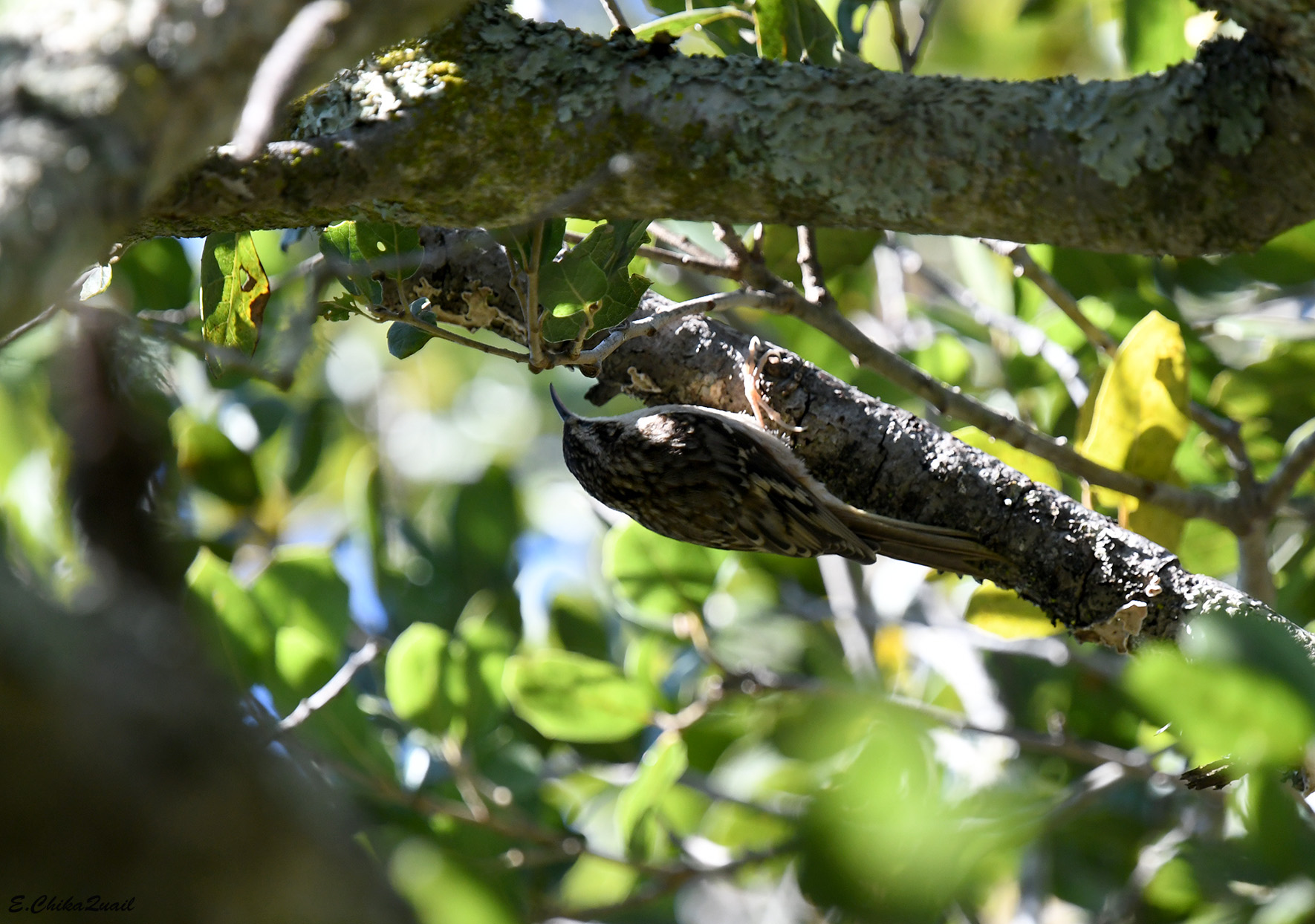
Brown Creeper

Another mushroom attracted my attention - it was brown and well camouflaged among the dry leaves but it was whole and pretty.

We reached the lake shore and doubled back to the north on Bass Cove Trail, along the shoreline. This was the north most end of Lake Chabot - a human made water reservoir, one of the earliest built in the East Bay.  The trail was about 12 ft above the lake, and there was no access to the water.
Bass Cove Trail

I found it funny that at the lake shore there was much less view of the lake than from higher up the trail. 
Lake chabot

We scanned the water surface for birds but all we could see were coots and a few mallards that were resting near the opposite shore.  
American Coot

It didn't take us long to reach the northern end of Lake Chabot. The end was clogged with tall wetland vegetation. A few more coots were swimming between the clamps of tule and horsetails.  

Past the open water there was a patch of very still water that was covered with duckweed - a small higher aquatic plant. It was so dense that it was very tempting to walk on, like a carpet. 

Past the lake the trail continued a bit more inland, following the lower part of Grass Valley Creek. There were plenty of rotting logs and branches strewn beside the trail and many of them bloomed with lovely-looking mushrooms.

The lower part of Grass Valley Creek is probably my favorite part of this loop trail. The path, which starts as a continuation of Bass Cove Trail but changes to Columbine Trail past the turn to the path that goes around the lake, is narrow, and deeply shaded by the arching boughs of laurel trees. I find the laurel fragrance that fills the air and the nostrils very pleasing. The sense of this section of the trail is very wild.

The trail goes right by the creek and crosses it a few times. It was easy enough to cross it on the day of our hike - there hasn't been much rain yet  this season, and the creek was low. I have hiked there though when the creek was running high and it was impossible to cross it without wading in the water.
Grass Valley Creek

My chika pointed out to me a jawbone on the mat of dry leaves. It looked like the jawbone of a deer. There were no other bones of that deer around and it could have been carried there from up the creek, just like the golf balls.

We didn't see any live deer that day, but interesting wildlife doesn't always come in large packaging - a funny looking water-walking insect marched gracefully on the calm surface of the creek. The flow was very slow and hardly noticeable - if not for the lazily moving vegetation particles one could have mistaken this to be standing water.

We found a few more cute mushrooms on the way. When it is off season for the wildflowers, the mushrooms take the colorful reproduction shift.

After crossing the creek back and forth a few times the trail started rising on the hill side, leaving the water flowing down below a deep gulch. There were many tree species growing along the trail and the slope of the gulch, including groves of thin eucalyptus.
Columbine Trail

Below the eucalyptus on the trail were a few dark-eyed junco birds that looked for something to eat. The eucalyptus is an invasive species in California but it had already become an important part in the local habitats. One of the most known beneficiaries of the eucalyptus are the monarch butterflies. I looked, but couldn't see any on the trees we were passing under.
Dark-eyed Junco

The first part of the ascend, on Columbine Trail, was fairly steep but short. The Columbine Trail continued steeply up to meet the Goldenrod Trail about where the golf course was, and we continued ahead on the Cascade Trail, which was now almost flat and much easier to walk. 
Cascade Trail

The Cascade Trail curved along the contours of the hill, high above the gulch's floor where the creek was flowing. In places where the trail was out of the trees we got a nice view of the opposite hillside. Once again those high power lines interfered with the pristine forest view.


One of the trees that I haven't seen many of earlier on the hike was the madrone tree. Poking its canopy above the other vegetation, it's smooth, reddish back glistened in the sunshine.
Pacific Madrone, Arbutus menziesii

I came upon a crack in the rock to my left, a crack formed by a widening oak root. I instantly recognized that crack: that crack has caught my attention on my first hike of this trail, and when I took a closer look I saw a garter snake curled below the root. There was no snake there now. Not that I expected to see any out in January.

Up the trail there is a small waterfall. Most of the year the creek (and waterfall) are dry, but now I was hoping to see it flow. I was happy to see that it was flowing, even if a trickle.

It was a short distance from the waterfall to the end of the Cascade Trail. We walked quickly now, both of us eager to finish the hike and have lunch. I paused briefly to admire the pretty white berries of the snowberry bush.
Common Snowberry, Symphoricarpos albus

At the next trail junction we turned left and ascended the short and steep dirt road that led back up to the staging area where we parked. On the way up I admired the "cross-legged" oak tree on the side of the trail.

Just before reaching the top and closing the loop hike was a toyon bush, laden with beautiful red berries. It was a very nice sight to finish our hike with.
Toyon, Heteromeles arbutifolia

My chika and I had collected about four golf balls on this hike. Granted - we didn't look for them, only picked up those that were directly on the trail. On the following day however, the 4-H kids were much more industrious in finding and removing the stray golf balls. We collected nearly thirty balls, some were very old and some looked brand new. We found them all along the trail between the golf course and the lake, and half way up the Columbine Trail. We saw many more golf balls that we couldn't reach so we had to leave where they were. I can only imagine how many of these plastic golf balls are resting at the bottom of Lake Chabot.