|
| April 7, 2019 |
Date: July 7, 2018 and April 7, 2019
Place: Natural Bridges Day Use Area, Vallecito, California
Coordinates: 38.052626, -120.471504
Length: about 2.5 miles in and out
Level: moderate hike to the south opening, challenging if going down to the north opening. Float/swim through the cavern requires coming down a steep rock face. Flashlights and floaters strongly recommended.
It took a couple of years since I first learned about the Natural Bridges cavern until I had the chance to visit there with my family last summer. Then I visited there again with the chikas and friends last spring and my impression was just as intense. The photos here are from both these trips.
We almost didn't go on this hike on our first visit. We arrived on a very hot Saturday, the chikas and their visiting cousin eager to get down to the promised water, Grandma Quail a little less eager to get out of the air-conditioned car and Pappa Quail who left his big camera behind not wanting to get it wet. There is a narrow strip of asphalt near the trailhead and it was already jam-packed with parking vehicles. After a minute or two of debating what's next we got lucky: one of the cars pulled out of its spot. Quickly we slid into the vacated space, got our drinking water and deflated floaters and headed to the trailhead gate. Another family was coming up and their little child was crying bitterly. They were focused on calming her down and said nothing to us as we walked by. Only a few steps down the trail and it was our young chika that started screaming and crying. She had stepped right on a yellowjacket hole in the ground right on the trail. The angry yellowjackets swarmed at us and we run back up to the parking strip. My poor young chika had 3 bites, Grandma Quail had one and the rest of us got lucky and escaped with none. It took a while to calm everybody and by that time Pappa Quail and I were ready to turn around and go somewhere else.
|
|
Near the Trailhead, July 7, 2018
|
It was the chikas and their cousin that insisted on hiking down again. Even the young chika who was still hurting from her bites. The heat was intense and the promise of a dip in the cool water of Coyote Creek was too alluring. So we took our stuff and started down again, this time getting off trail to bypass that hornet's nest.
Below is a photo of that same spot I took last April. There were no yellowjackets waiting for us then, and the difference in the scenery was striking. It was amazing to see the place all green and lush. There were also much fewer cars parked uphill and for most of the time we saw very few people along the trail or down at the creek.
 |
| Near the trailhead, April 7, 2019 |
Our April hike also presented us with a very nice bloom scene. We were rushing downhill and I had only my little pocket camera with me so I didn't photograph most of them, only those that really stood out.
 |
| Western Redbud Cercis occidentalis, April 7, 2019 |
Some of the wildflowers were just beginning to bloom, which made it hard for me to identify them. Thankfully I got help at the California Native Plants Society forum :-)
 |
Leather Root, Hoita macrostachya, July 7, 2018
|
On our previous hike in July we've seen no bloom. Everything annual was already parched dry and even the perennials seemed tired and yellowish under the bright summer sun. Fruit were hanging from shrub and tree branches, and none as pretty as those of the Clematis. They always remind me of Traffula trees.
 |
| Clematis sp. July 7, 2018 |
The trail drops down to the creek going south first, then switch-backs to the north. Most of the way is under the trees and whatever shade we got was gratefully welcomed. We couldn't wait getting to the water, and I couldn't avoid the thought that all that slope was waiting for us on the way up.
 |
| Natural Bridges Trail, July 7, 2018 |
About two thirds of the way down the trail emerges from the trees and a nice view of the canyon opens up. The water cannot be seen, hidden well by the tree canopies. Gray pines and reddish manzanita dominated the view, and all looked in suspension, waiting for the rain that wouldn't come for a few good months yet.
 |
| July 7, 2018 |
It was quite stunning to look at this very view nine months later, after the heavy winter California had.
 |
| April 7, 2019 |
The reason why I wanted to hike that trail wasn't just that Coyote Creek is a nice place to take a dip in the summer, but because the creek flows through a beautiful cavern with pretty rock formations. Until that hike I have only seen it in photos and it looked like it would be a very exciting place to visit. Now we were getting very close to the place and needed to find the path down to the water.
Before going down the last drop to the creek the trail follows the edge of a cliff. A bit too close to the edge at one point.
 |
| July 7, 2018 |
Just above Coyote Creek there is a steep trail with a few stairs leading down to the south opening. On our July hike, Grandma Quail had already decided that she won't be floating through the cave with us so she went down to wait at the south opening and we left with her all the stuff that we didn't want to take on the water. On our later, April hike it was our friend's parents that remained to wait there.
 |
View down to the area of south opening of the cave, April 7, 2019
|
Going down to the north opening is challenging. A number of unofficial trails made it difficult for us on our first hike to find the path to the north (upstream) opening. After we found it we discovered that to get town to the creek we needed to scramble down a fairly steep rock. On our July hike there was a sturdy rope anchored to the top of the rock that aided a great deal in going down. The rope was missing on our second visit so we had to scramble down unaided. It is certainly doable but if coming with little children or people who might have difficulty with rock scrambling I strongly recommend bringing a rope or even a rope ladder to aid with the descend.
There were quite a few people down at the north opening and my next challenge was to get a people-free photo of the creak upstream of the cave.
 |
Coyote Creek upstream of the cave. July 7, 2018
|
We took a while to inflate all of our floaters. I made our party wait a bit until most of the people who were there went into the cave and disappeared in the darkness. I couldn't hold back the chikas for a clean shot of the cave mouth. They were hot and too eager to get in the water.
 |
| The north opening of the cave, July 7, 2018 |
I add the matching photo from our later, April visit to show the contrast between the dry and the wet seasons. It is quite a striking difference.
 |
The north opening of the cave, April 7, 2019
|
The water was very cold. Surprisingly, I thought it felt colder in July than in April. Perhaps it was the contrast with the air temperature, which was very hot in July and much cooler on or April visit.
Once getting into the cave I could see that all the people that went in before us were still hanging there, floating lazily on their tubes with no apparent hurry to get anywhere. (I distorted the faces in the photo to avoid recognition).
Pappa Quail, the chikas and their cousin snaked their way between the others, then settled on their tubes and floated into the darkness.
 |
| July 7, 2018 |
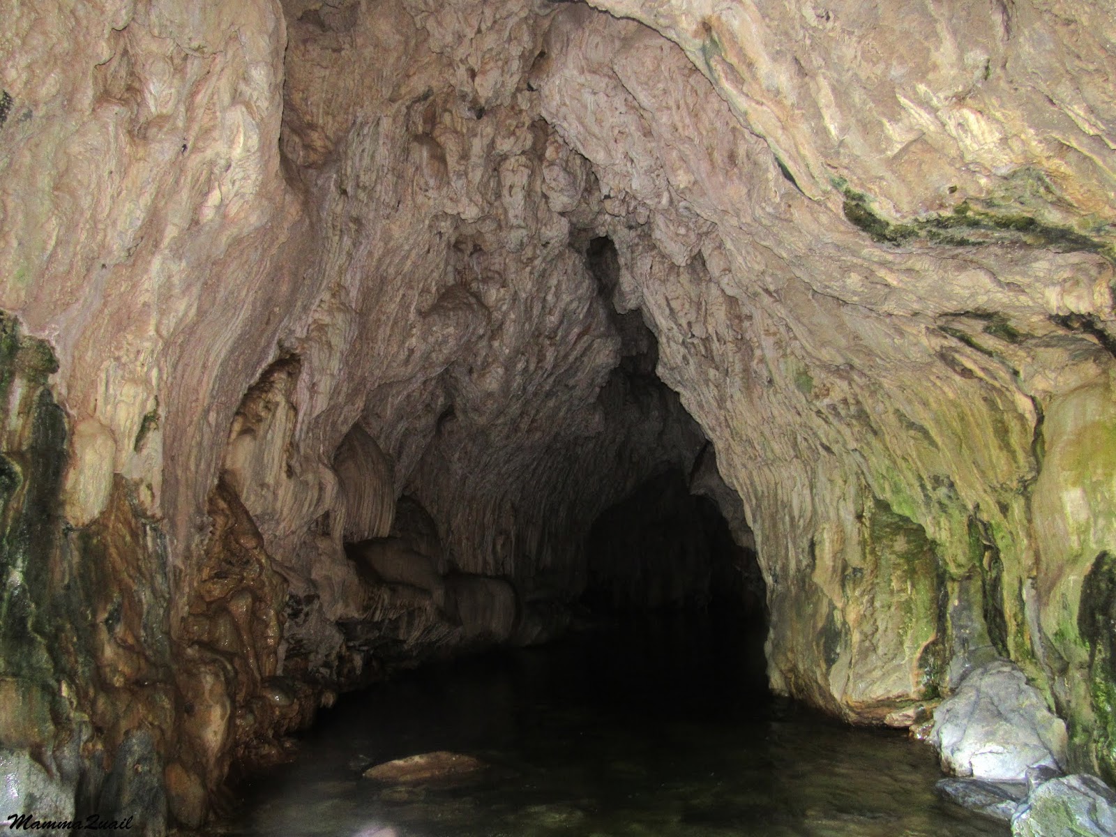
I followed my family and once I cleared the other people I stood up and took photos of the cave. It was an easier task the second time around because I came with better splash protection for my little camera. Still, most of my photos came out blurry for poor lighting, or distorted due to water droplets that landed on my lens. Still, I got a few nice ones to show the magnificence of the cave.
 |
April 7, 2019
|
There are many karst caves in the Gold Country of California, may of them unknown and unopened to the public. Some of the most beautiful caves are open for guided tours. Two of those are very close to the Natural Bridges cave. The Natural Bridges cave is open to the public year round, no guided tours, and no aiding scaffolds. No stairs or crawling, no boardwalks and while flashlights are recommended (mainly to see the rock features) they are not necessary. There are also no fantastic rock formation like those seen in the other caves. Still, the rock formations of the Natural Bridges cave are very beautiful and interesting.
 |
| Rock formation, July 7, 2018 |
Going through this cave is an excellent way to combine a sightseeing of the geological wonders the area has to offer with a very cool (double meaning intended) passage through this cathedral of Nature.
I do not know how deep is the water throughout the cave because I didn't try to stand there, but it seemed quite deep on parts. Swimming, or a floater are needed to pass through (and swimming there would be a very cold experience and would make photographing much more challenging).
 |
| July 7, 2018 |
The cave's ceiling drips water. All the water that the rock above absorbed during the rainy seasons dripping on us as we passed through. Even on our July visit after the fairly dry 2018 winter.
 |
| July 7, 2018 |
Most of this dripping happens near the south opening of the cave. Those of us who were careful enough to keep our upper bodies dry during most of are passage were now getting soaked as we floated through the ceiling showers that screened the cave's south opening.
 |
April 7, 2019
|
I tucked my camera under its cover and passed through the cave shower. Outside I turned to take a photo of the raining vegetation at the opening and found that the lens did get some splash after all.
|
|
The cave's south opening, April 7, 2019
|
Outside the cave we rejoined Grandma Quail and sat on the hot rocks to deflate the tubes and to dry off. I wandered a bit downstream to get a people free shot of the creek.
 |
Coyote Creek downstream of the cave, July 7, 2018
|
Meanwhile the chikas and their cousin got busy exploring. The elder chika found some tadpoles and after taking the photo I had her take it back to the water. I hope it grew into a nice frog.
 |
| Tadpole, July 7, 2018 |
I was amazed at how quickly the cool of the water faded away and we were hot again. Gathering our things we started our hike uphill. I took a final look at the picnic spot just above the south opening area. It was completely deserted because who would be fool enough to bake there in the hot sun when the cook creek is only a few steps down?
 |
| July 7, 2018 |
We hiked up the trail quickly, and remembered to bypass the yellowjackets on our way back. Although we did dry off before setting out on our return hike we were all wet again wen we got to the car, this time with sweat. Our second visit there was much nicer in that sense, and also much less crowded. If we only wanted to pay in the water we could have gone to the nearby New Melones Reservoir. But this hike is definitely worth it because of the cave and the wonderful way to pass through it. I have no doubt that I'll be there again.
Many thanks to members of the California Native Plants Society for their help in identifying plants!