Sunday, October 25, 2015

At the Condor's Nest: The High Peaks of the Pinnacles

Date: April 9, 2015
Place: Pinnacles National Park
Coordinates: 36.481456, -121.181377
Length: 6 miles
Level: Strenuous

The High Peaks of Pinnacles National Park can be seen from Hwy 101 when passing the town of Soledad. The stand out, strange, beautiful, and alluring. Last April, on the second day of my solo post Spring Break vacation time, I hiked a wonderful loop trail going up Condor Gulch, ascending the High Peaks trail from north, and descending through Bear Gulch Reservoir and Cave.
My hike to the Pinnacles High Peaks as captured by my GPS
On the previous day I had hiked all the way from Old Pinnacles to the Balconies, making it back with very little daylight to spare. Not wanting to have to race my trail again I was out by the trailhead really early. I took the time to have my breakfast there and then hoisted my day pack and started up the trail. It is a nice ascend: a good, clean and easy trail, that's not very steep, yet constantly ascending. I walked slow, appreciating the views.
Unraveling Pinnacles
Condor Gulch was deep green with lush vegetation and spring bloom was all around me. On my first steps I already encountered my prized flower: the Mariposa Lily. Many of them, in fact.
Butterfly Mariposa Lily (Calochortus venustus)
Besides the mariposa lilies there were many, many other flowers. Not all of them California native.
Star Thistle (Centaurea sp.) Not native.
Wildflowers are a springtime spectacle, but the Pinnacles rocks are gorgeous year-round.
Whenever I see a hole in a rock I wonder what's living in there. Usually it's too dark for me to see, and not always I have the time or patience to wait until I see something goes in or out.
Knock knock! Who's in there?
I didn't stick around to see if anything flies out of that hole in the rock. The flowers were much more interesting.
Venus Thistle (Cirsium occidentale var. venustum)
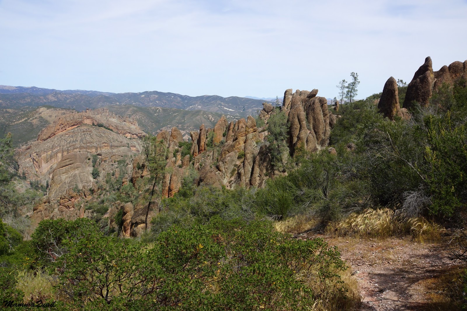
 But as I was getting higher, the rock pinnacles came into view with all their of striking beauty.
The remains of an old, eroded volcano, the colorful rock formations stand against the sky in stubborn defiance of all the erosion forces, a geological testament of the forces in action in the Earth's mantle.

Standing out in soil composition, height and climate, the Pinnacles make a unique and fascinating ecosystem combining riparian, chaparral, and rock face and scree.
And rock face and scree is not usually a place where one expects to see ferns. The Pallaea, however, had evolved to fit these conditions, which are too extreme for other fern genera.
Bird's Foot Fern (Pellaea mucronata)
About half way up Condor Gulch there is a nice overlook on the gulch and the narrow, curving rock groove that channels the creek water down to a big drop.
Condor Gulch Overview
Despite the gulch's name, I did not see any condors there, or anywhere on that trail that day. There were plenty other interesting sights, though. Like the mosaic of volcanic stones embedded in the volcanic ash, pressed all together into a huge conglomerate.
Volcano Mosaic
I wasn't the only one there who appreciated that rock: little fence lizards were sunning themselves out in the open, and didn't budge when I passed by, just followed me with their eyes.
Western Fence Lizard
I kept going up. The trail isn't very steep, and on some segments it is almost level. Higher up, before meeting the High Peaks Loop, the trail goes through chaparral: a contiguous thicket of bushes adapted to low precipitation.

Chaparral comprises of several dominant bush species that vary between geographical areas. In the Pinnacles, chamise and manzanita are most dominant chaparral species, but other bushes make a strong appearance as well. Like the beautiful bush poppy that was in full bloom at the time of my hike.
Bush Poppy (Dendromecon rigida)
On my previous hike up the Pinnacles on December 2014, the Indian Warrior was just beginning to emerge from the ground. By April, it had already finished blooming. Thorny leaf rosettes with rusty fruiting stalks were all I could see of this magnificent plant.
Indian Warrior (Pedicularis densifolia)
Although the Indian Warrior was done, plenty of other wildflowers were at their peak bloom:
Bitter Root (Lewisia rediviva)

The patch of bitter roots was growing near the trail intersection. After a short break I turn left onto the High Peaks Loop and kept ascending. As I was getting higher the views opened up below me.
Jagged Rock line, like a multi-pointed crown on a giant king's head
I was walking at the heart of the Pinnacles. No more mild, round contours, but a field of ancient mythical figures turned to rock with a wave of a magic wand.

I made my way between these Nature's statues, quietly naming them, allowing my imagination to spin plots with their characters.
Rock Creatures
Higher up the air was cooler and the soil more moist. I saw the Bird's Foot fern again, green and lush in the shadier spots.
Bird's Foot Fern (Pellaea mucronata)
The little alluvial flats and slopes up between the rocks were full of  wildflowers. There were lots of Chinese Houses there.
Purple Chinese Houses (Collinsia heterophylla)
And in between them: large stalks of larkspur.
Larkspur (Delphinium sp.)
The common tree up on the Pinnacles slopes is the gray pine. A beautiful species in which; like oaks, every individual shows personality. In my April visit I saw many baby pines sprouting all around the park. The next generation is here :-)
A sprout of Gray Pine (Pinus Sabiniata) 
Turning the corner I saw all the way down to the Chaparral parking area: the trailhead for the Balconies when entering from the west side of the park. The one time I had hiked to the High Peaks was from that side, 17 years ago.
Way up high: the view northwest from the High Peaks
Up on the mountain the trail snakes very tightly between the rock pillars. Occasionally the view opened up a little, and when that happened I got a good appreciation of how high I really was.
Bush Poppy (Dendromecon rigida) at the High Peaks
Whatever little soil accumulates in rock cracks, it is enough for the gray pine. But sometimes it just isn't enough to hold it upright.
Hugging the rock: Gray Pine (Pinus Sabiniata)
The High Peaks is a loop trail. I connected with the loop from the north and decided to hike only the higher (eastern) side of the loop and descend on the other (south) side.
And so I had more altitude to gain.
High Peaks: A view to the southwest
And the trail had become considerably more challenging. 

I progressed slowly through a series of rock-curved stairs and terrifyingly narrow trails hanging over sheer cliffs with only a single-bar rail to hold on too at some parts. The trail took me up the highest pinnacles and in between the most striking pillars of rock. I touched each and every one of them, and wondered if there's any social status for the 'Rock Hugger' I had become.
Up the High Peaks: view to the east
Almost without noticing, I was slowly losing altitude. So engrossed I was by the beauty of the Pinnacles heights that it took me some time to realize I was already descending.

And all at a good time too, because the sun was already going west.
A 'window' with a view of the magical world beyond. 
As I got my spinning mind to calm down I once again focused on the wildflowers.
And on the critters that pollinate them.
Holly-leaved Cherry (Prunus ilicifolia), with a bee
It was, in fact, the first year I had visited the Pinnacles during springtime, and many of the wildflowers I saw were completely new to me.
March Zigadene (Toxicoscordion fontanum)
So even though the trail down was nice and easy, I descended it slowly and photographed a lot.
Grass Blazingstar (Mentzelia gracilenta)
The color wasn't limited to wildflowers only. The rocks themselves bloomed with colorful lichen growth.

Down and down I hiked, heading southeast towards Bear gulch. I left the High Peaks Loop and its south end and then the slope steepened considerably.
Yellow Whispering Bells (Emmenanthe penduliflora)
Blues and yellows changed to pinks and purples. A few snapdragon bushes on the trailside, and fellow members of the California Native Plants Society had learned me that this plant tends to grow in recently burnt or otherwise disturbed areas. I don't recall seeing any fire scars in that area, however.
Chaparral Snapdragon (Antirrhinum multiflorum)
Far below me stood a tight group of rock pillars. On the following week when I returned to the Pinnacles with my hiking group, it turned out to be the perfect spot for a rest stop.

Down, down, down. The trail meandering around the mountain curves, between rock formations, and in one case: right through the rock.
A curved tunnel where the trail goes.   
Changing shaded slopes to open scree and chaparral, different plants were now blooming by the trail.
Onion (Allium sp.)
And rock formations that didn't look like much from high up were now revealing their true nature, when looked at from below.

A few bushes with purple branch tips grabbed my attention. On close inspection I saw that the purple tips were covered with dense, woolly threads. On first impression it looked to me just like some kind of fancy fungus infestation. But it was way too regular to be that. This is how the budding inflorescence of the woolly bluecurls bush look like. And a fitting name it has!
Woolly Bluecurls (Trichostema lanatum)
I kept going down, descending towards Bear Gulch Reservoir.  I was getting tired and looked forward to having a rest stop near the water.

But the shadows are growing longer. I knew I wouldn't be able to rest there for long. I pushed on forward.
A busy chipmunk crossed the trail a few time, keeping a cautious distance from me.

The vegetation on south-facing slope, if not exposed rock, was mostly chaparral. The bushes were blooming furiously. And so were the herbaceous plants.
Chaparral Clarkia (Clarkia affinis)
At last I was near Bear Gulch Reservoir. This reservoir was built in 1934 to provide water to Civilian Conservation Corps who had a nearby encampment in the years 1933-1942. 
Bear Gulch Reservoir
It was getting late, so despite my fatigue I took the shortest rest stop ever and quickly moved on. A week later, however, when I returned to the reservoir with my hiking group, we took the time to enjoy the place. A little garter snake fascinated by our presence glided over on the water and regarded us for a long time without any apparent concern.  
Garter Snake
On my solo hike though, I went right down the stairs and into the Bear Gulch Cave. I already posted here about that cave so I won't add more photos here. Besides, I had the camera safely tucked under my shirt at the time: the cave's ceiling was dripping water. It was literally raining inside the cave.
I am posting one photo from my passage through the cave, and that is of a rock pigeon couple, checking out a potential nesting site.
Rock Pigeons
Through with the cave, I increased my pace and darted down the path all the way back to the parking lot, where I finally allowed myself to take a long breath and get acquainted with the local Steller's Jays.
Steller's Jay

I returned to the campsite with enough daylight to walk around a look at birds :-)


Many thanks to members of the California Native Plants society for their help in identifying plants and enhancing my knowledge of them!


Saturday, October 17, 2015

The Quiet Side of Bear Gulch

Date: December 25, 2014
Place: Pinnacles National Park, Paicines, California
Coordinates: 36.481344, -121.181452
Length: 1.5 miles one way
Level: moderate

The Pinnacles National Park has been a blazing hot spot for me in the past year and I had opportunities to explore trails a bit outside of the popular areas.
Bear Gulch Cave and Reservoir are very popular attractions to people visiting the Pinnacles NP. The downstream part of Bear Gulch Creek, however, is hardly a hike by its own right. Skipped by most Bear Gulch visitors, this trail segment which connects the cave and reservoir to Chalone Creek, is generally hiked as part of a larger loop hike. This is also how I got to hike that trail. It does, however, an interesting and very beautiful trail that can easily be incorporated into a Bear Gulch Cave hike if started at the campground or the Peaks View parking area.

When I hiked Bear Gulch it was the final segment of a larger loop trail that begun at the Old Pinnacles parking lot, continued up by the High Peaks and descended to the Bear Gulch Parking lot. To get back to my car I needed to go down (east) along Bear Gulch Creek and back up (north) along Chalone Creek. This post is only about that trail segment.
My hike from Bear Gulch to Old Pinnacles
It was already late in the afternoon when I arrived at the Bear Gulch parking area.  And it was 4 days after the winter solstice, meaning I hadn't much daylight time left. So although I was after a good, long hike already, I didn't stop to rest but continued on down the trail along Bear Gulch.
Following two wet months, the creek was flowing nicely and green vegetation grew along its banks.
Hello Mr. Sunshine!
Near the nature center (which was closed at the time) there are large oaks, many of them holed by acorn woodpeckers to be used as granaries. Although I've seen the birds there on other visits, they were somewhere else at the time.
Acorn Woodpecker's Granary
As I got further away from the nature center the trail became very quiet. While there were a few people up by the parking lot, down by the creek I was all alone. Just me and the wilderness.
The trail follows the creek very closely. Many of the plants at the creek banks looked flattened and there were piles of vegetation debris lodged at the turns. Evidence of e recent flood, no doubt.
Deergrass (Muhlenbergia rigens) by the water
Bear Gulch is deep and narrow, and is well shaded under tree canopies. Mostly oak, but also others, such as maple. A thick layer of fallen leaves matted the ground and a deep, earthy fragrance hung in the air.

The damp season is the time for fungi fruiting. While not a spectacle as the NorCal coastal mushroom bloom, Bear Gulch mushrooms were still a much appreciated beauty. 
Bolete Mushroom
And I even saw a mushroom there that I didn't see in the redwoods.

Ferns lined along the entire path. They, too, looked healthy and happy after two months or rain.
Western Chain-fern (Woodwardia fimbriata)
The sun was still up but down in the deep gulch it was already getting dark. The dense oak canopies deepened the shade and the evening chill was upon me.
Canyon Live Oak
I kept striding downstream along the trail. Other than a few little brown birds I didn't see much wildlife there. What I did see, however, was a very interesting sight: large clusters of ladybugs sticking together for warmth.
Hibernating Ladybugs
As the light was fading, taking photographs was becoming more and more challenging. Not wishing to be on the trail after sunset, I hurried down the path.

Eventually the sun was no longer shining into the gulch. I put on my sweater and raced past a beautiful cascade area that really should have been explored with more leisure, but would have to wait until the next time I hike that trail.
Bear Gulch
And then, almost suddenly, I was out of the gulch and in the wide-open Chalone Creek. And it was sunny there still.
Chalone Creek

I very tired by then and was sorely tempted to sit down and take a little rest in the afternoon sun, but I still had over a mile to walk and the shadows were long.
Late Afternoon at Chalone Creek
Indeed, before I got to Old Pinnacles, the sun had set and, all of a sudden, the temperature plummeted.
Dusky Chalone
There was some light still when I made it back to my car but it was already nighttime when I exited the park. I stopped briefly to appreciate the stars-strewn skies and then plunged into the long drive home. Over three months would pass before I'd be back at the Pinnacles. By then, it would have a completely different look and feel.


Friday, October 9, 2015

Second Time and Lots of Charm: Up (and Down) Mount Pinos

Date: August 14, 2015
Place: Mt. Pinos, Frazier Park, California
Coordinates: 34.813477, -119.126516
Length: 4 miles up and down
Level: easy to moderate

Our first attempt to hike up Mt. Pinos was on the 2015 Spring Break, following our visit of Carrizo Plain NM. When we arrived at the parking lot we were met by harsh weather and decided to abort, swinging by the west Pinnacles on the way home.
Last August I had the opportunity to go back to Mt. Pinos, this time without Papa Quail, who was away on separate business. The chikas and I were returning north after visiting friends in Southern California. I planned to cover the distance in two days, one for a hike and the next for the beach. The night between I wanted to camp at the Valle Vista Campground.
Mt. Pinos is 8,848' high and can get a fine winter snow cover that attracts area cross-country skiers. The road pavement up the mountain ends in a base camp parking lot, about 2 miles shy of the summit.
Last April the lot was deserted. When I arrived there on August 14, there were many trailers and RVs parked about in no apparent order, and in between the vehicles stood numerous telescopes of various sizes. That night would be the third in a row that a strong meteor shower was expected.

By the time we arrived at the parking lot of Mt. Pinos, 2 miles shy of the summit, the chikas were in hearing Nature's call quite loudly. The long line of porta-potties that I saw there on April was gone so, ignoring the red patch of scarlet bugle penstemons by the parking lot, I  hurried the chikas down the 200 yards' path to the nearby campground.
I didn't ignore them on the way back: Scarlet Bugler Penstemon (Penstemon centranthifolius)
I probably wouldn't have mentioned our little restroom diversion if not for two things, one being the nasty litter of human waste around the parking lot (goddamit! the restrooms arejuast 200 yards away! and even if you cannot hold it that far, you shouldn't be leaving it out like that! Bury it and pack out the toilet paper! Yuck!)

The other reason was quite a nice surprise and that was a sole yellow-flowering penstemon that stood out in a field of regular red ones. Because we were in a hurry to get to the campground I took just a quick photograph, hoping to take better shots on our return. Unfortunately on our way back to the parking lot and trailhead I was too busy trying to resolve a conflict between the chikas and missed that unique specimen.
Penstemon sp.
Back at the parking lot we got our backpacks and started up to the summit. The trail is a broad dirt road that's easy to follow all the way up. We went up and down that same trail.
Our hike from Mt. Pinos Base Camp (the right end) to the summit (the left end) marked in yellow.
The altitude isn't a problem there and the trail ascends in a mild slope through an open forest of (mostly) pine trees.

Still, the chikas started complaining almost from the start. We didn't even make it to half a mile before we had to stop for them to rest and snack and for me to breath deeply and say 'ohm' a lot.
A great place to take a break

A good, natural forest showcases quite a few tree personalities. While oaks are usually more expressive, the pines of Mt. Pinos can be quite wild in appearance too.

Within a mile the trail leveled almost completely and we walked out of the woods and into a large meadow painted intense yellow with rabbitbrush.

There are several species of rabbitbrush in that area, and I believe I have identified two of them in that meadow. The differences are slight, making it a challenge to tell the species apart.
Parry's Rabbitbrush (Ericameria parryi) and bee
There were many bees about the rabbitbrush, all of them solitary bees. Younger chika was a bit worried about them, but I reassured here that the bees had no interest in her whatsoever. They were into rabbitbrush, not roses.
Stickyleaf Rabbitbrush (Chrysothamnus viscidiflorus) and bee
We did not see any actual rabbits there, although I'm quite sure they were somewhere around.
Bees weren't the only creatures with interest in rabbitbrush. Elder chika found a big caterpillar chewing on the plant. 

Although the trail was much easier we had slowed down considerably when crossing the meadow. There was so much to see there! Although not as high as the Sierra Neveda, Mt. Pinos is high enough for having an excellent bloom in mid-August.
Bunchleaf Penstemon (Penstemon heterophyllus)
There were quite a few lupines in that meadow, well spaced between the rabbitbrush. Some of them were already past peak bloom.
Pacific Lupine (Lupinus lepidus)
And others were still going strong.
Sickle-seed Lupine (Lupinus albicaulis)
A narrow  trail split off the main trail and lead to a nearby hilltop. I beckoned the chiks and we followed the trail to the tip.
A perfect meditation point
While I would have loved to sit there quietly and contemplate, the chikas were restless and after looking around a bit we strolled back to the summit trail and continued up.
Rabbitbrush is the perfect color match for Indian Paintbrush
Rabbitbrush is a perfect color partner to any other flower color. Every color pairing works with it.
Tall Stephanomeria (Stephanomeria virgata var. pleurocarpa)
As we went on the chikas started another argument that quickly escalated in tones. I hurried to find a suitable diversion for each of them. Elder chika would have been happy to find me birds to photograph, but none of the happy chirpers in the brush would show themselves so she settled for looking for gems.
Not a gem, but pretty and shiny nonetheless.
We passed another patch of forest and entered a second meadow area, where the plants were much lower, stretched on the ground in flat cushions, as common with Alpine plants.
Kennedy's Buckwheat (Eriogonum kennedyi)
Even the lupines there were small and flat. In contrast with their lower-altitude relatives, they had just begun blooming.
Brewer's Lupine (Lupinus breweri)
We were very close to the summit when my elder chika sat down and said she would not go any further.
We sat too. Had a little snack and rested.
When it was time to go on, she got up and continued without a protest.
At the summit there is a small parking area that looked like it has not been used in a long while. There were also benches and information post signs.
And there was view. Wonderful view.
At the Summit - View to the southwest
The chikas slumped on one of the benches while I walked around, reading the signs and enjoying the view.
Double-Tree (triple, actually)
And there were flowers at the summit, too. A beautiful one that I've seen many of - the delicate prairie flax.
Prairie Flax (Linum lewisii var. lewisii)
An antenna-bearing second peak, very close in height was just a short distance east of the summit. I prompted the chikas to move and, without staying to listen to their groans, I hurried to that second peak, where I found the view just as appealing (and less so the half-empty beer can that was left there by a previous visitor).
At the Summit - View to the southeast
It was all downhill from there. After duly taking our own photos at the summit we started back on the same trail we came up on.
And I was just as attentive to the flowers as I was going up.
One-seeded Pussypaws (Calyptridium monospermum)
It is my habit now to try and document every flower I see on the trail. One never knows which flower will turn out to be an interesting find. Even the simplest-looking flowers may turn out to be unique. 
Heermann's Lotus (Acmispon heermannii)
And then, there are those flowers that you know are unique right on the spot. It was only in the way back that I found the flower that made my day: a Mariposa Lily!
With seconds the entire attitude of the chikas changed a 180 degrees and happily, they spotted many more lilies for me to photograph. I couldn't believe that I had missed them on the way up.
Plain Mariposa Lily (Calochortus invenustus)
We had a much better time coming down the mountain than we had going up. The chikas had ceased their bickering and at last, were engaged in the beautiful Nature that we were walking through.
Gooseberry (Ribes sp.)
And so they found the only vertebrate on the trail that was out long enough to get on camera, if only at a distance and in the shade.
Chipmunk
Coming down the mountain was (surprise, surprise!) much quicker. But not too quick to pay attention to the interesting-looking trees along the way. Some trees that looked plain on the way up were showing a completely different side of their personality from the other direction.

We slowed down again as we approached the base camp. Although eager to get back in the car, the chikas needed some rest (this time for real). That final break allowed me a few minutes more to absorb the mountain forest air.
Common Yarrow (Achilea millefolium)
Back at the parking lot I waved farewell to the stargazers, wishing them good sightings and hoping that they'll bother taking the trail to the campground's restrooms and won't deposit any additional waste near the parking lot. 

After leaving Mt. Pinos I drove leisurely west to the Valle Vista campground. The view of the valley was stunningly beautiful indeed.
View northeast from Valle Vista Campground
The campground, however, was in a sorry state. The dirt road was all eroded and pot-holed, making it very difficult access to a none 4x4 to get down there. The lower part of the campground was completely inaccessible to us because of the road condition.
The upper part was filthy with trash that was left behind by people with absolutely no regard of Nature whatsoever. And when we did manage to find a side that was sort of acceptable, we discovered it was already occupied by a multitude of fire ants. So after taking a few photos of the beautiful valley we went back into the car and continued on westward, hoping to find another campground.
View southeast from Valle Vista Campground
The next campground we found, at Aliso Canyon, looked much more promising. It is quite desolate, and when we were there it looked cleaner. I already pulled the tent from its case when some of the other campers pulled out a rifle and started shooting  at something. I hurriedly stuffed the chikas and the tent into the car and took to the road again. By then it was too late to find another campground. We crashed in a hotel room in Santa Maria.
The following day we had a fantastic time at Oso Flaco State Park and Beach that completely eliminated all the bad taste that was left from our failed camping attempts.