

Date: August 13, 2016
Place: Devil's Postpile National Monument, Mammoth Lakes, California
Length: 6 miles
Level: moderate
Several years ago we decided to go on a road trip along the southern part of California Hwy 395. One of the places we visited was Devil's Postpile National Monument. It was one of many other sites we had visited on that trip and I have very few memories from that visit. This summer I had the chance to go there again - and this time I was focused on creating unforgettable memories.
Devil's Postpile NM is a small area west of the town of Mammoth Lakes, east of Yosemite National Park. The monument features an ancient lava bed that crusted in the form of hexagonal pillars of basalt. This formation is amazingly beautiful and awe striking and I cannot imagine why anyone would give it a devilish name.
We were getting to the end of our August Sierra Nevada road trip with Grandma Quail and Papa Quail's nieces that were visiting us this summer. We arrived at Mammoth Lakes after having to change the car tires, following our adventure at the Ancient Bristlecone Pine Forest the day before. Arriving in late morning after the long drive from Bishop, the parking lot at the Mammoth Adventure Center was already full and we had to find a spot along the road and walk up to the shop where we bought our bus tickets.
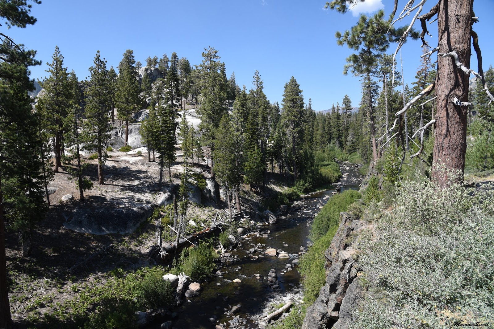
There is no car access to the Devil's Postpile, unless with a special permit. There is an all day shuttle that runs back and forth from Mammoth Lakes to the National Monument and the adjacent Reds Meadow Resort. The bus has 10 stops in that area, with trailheads leading into the forest and down the river. We got off at the Postpile stop where we listened to an introduction given by the ranger, filled our water bottles and started down the trail south to the famed rock formation.
The river that runs through the Devil's Postpile National Monument is the middle fork of San Joaquin. It isn't very big there, and in most places quite shallow. It does support some nice riparian vegetation such as groves of willows.

The trail follows the river downstream, southward. For the most part the trail is far above the river but it does start at the water level and I took the chance and went down to feel the water.
 |
| San Joaquin River, middle fork. |
The Postpile is surrounded by a small loop trail. To get to the top of the Postpile we had to make a right turn and climb uphill. Some in ur little company argued a bit but Grandma Quail tipped the scale by vocally remembering how beautiful it was up there when she'd been there last.
So we hiked uphill to the top of the Postpile and sat down on the flat hexagons.
 |
| Bassalt hexagons under a manzanita cover |
The hexagons form when lava cools down slowly and the newly solidified basalt cracks along the lines of least resistance.


After our break on top of the Postpile we had a little debate after which everyone else except for me and Papa Quail's eldest niece went back down the same trail came up on. Me and Papa Quail's niece continued on and completed the loop, meeting the rest of the family at the bottom of the Postpile.
This area used to be part of Yosemite National Park but in 1905 it was made public to allow for gold mining and other prospecting in the area of Mammoth, and only after the efforts by early conservationists including John Muir the postpile was protected as a National Monument.

The top of the Postpile is very beautiful but the view from the bottom is absolutely stunning. While basalt hexagons aren't all that rare, the formation seen at that National Monument is vey impressive. The stacks of the basalt pillars capped with Jeffrey pines and the pile of broken posts that flaked off the stack give the place the feel of an archeological site.

The broken posts reminded me of ancient greek structures I've seen, only without the carvings and statues.

After joining the rest of the family we hiked up little, and then continued south towards the Rainbow Falls. The ranger at the small visitor center had suggested that we take plenty of water with us and it was a very good advise because the day was hot and the hike was mainly in the open.
We were hiking through a thin pine forest that had many clearings with many little pinelets growing around large fallen logs.

Those clearings are the outcome of the great Reds Meadow Blowdown on 2012 when a wind storm with gusts measuring over 100 mph uprooted many trees in the valley.

The open forest areas promotes the growth of shrubs and herbaceous plants. Although quite late in summer, many of them were blooming still.
 |
| Rabbitbrush (Ericameria bloomeri) |
 |
| Wire lettuce (Stephanomeria sp.) |

Not catering for bugs or birds, the wind-pollinated grasses don't normally show interesting colors or shapes. Yet, their delicate spikes have a fairy-like beauty that attracts the eye and the camera lens.

Every now and then the view opened up and we could see the mountain tops that surround the National Monument. The mountains call me and I go to them. Physically, whenever I can. Mentally - every day.

We sit down once more - my little chika says her stomach is upset. Everyone else seems affected by the heat. I am restless, walking in circles around them. When everyone gets up from the log they were sitting on I get a chance to take a closer look at the plant that was blooming near it.
 |
| Short-leaved Alpinegold (Hulse brevifolia) |
 |
| Violet-green Swallows |
Behind the devastation area is the bald top of Mammoth Mountain.
 |
| Mammoth Mountain |
 |
| Fireweed (Chamerion angustifolium) |
The human inflation didn't seem to bother the small forest rodents. In fact, I think they were hanging around the trail on purpose.
 |
| Least Chipmunk |
 |
| Rainbow Falls |
We sat down at the balcony for a snack break. A local squirrel was running between the people, begging for treats. While many people took the chance to photograph the little critter, I am glad to say that at least while I was there, no human shared food with it.

So, no feeding of wildlife, please! No matter how cute they look and how intensely they beg.

After we had are time at the Rainbow Falls came the question of what's next. We could go on to the Lower Falls that were about half a mile downstream, For most of our party that was a no question at all - Grandma Quail and one of the nieces announced that they aren't going any further. The chikas immediately said they'll be going back too. Papa Quail's elder niece said she'd like to go on. Papa Quail sighed. He gave me his GPS and started back up the trail with his mother, daughters, and younger niece.
Me and Papa Quail's elder niece continued on to the Lower Falls.

The trail continues south along the river. Dense riparian vegetation separated us from the water, but on the other side of the trail it was dry soil and mostly open view. A good location for lupine shrubs to grow.
 |
| Silvery Lupine (Lupinus argenteus) |
 |
| Sierra Gooseberry (Ribes roeslii) |
 |
| San Joaquin River, middle fork. |
I was surprised to see how many ferns were growing there, in such an open, and seemingly dry area.

We arrived at the top of the falls. A man carrying a large camera and a tripod was coming up from below. He informed me that the area is full of people and said that if I wanted to get a people-free photo of the falls I should go up the opposite slope. I thanked him for the tip and he moved on.
 |
| The view south of the lower falls. |
The base of the lower falls was in deed very crowded. There were people sitting all along the pool at the bottom of the falls. Many people were also swimming in the pool, climbing on the surrounding rocks, and even sitting on top of the falls. I had managed to find a brief people-free moment and photographed the falls. And even this photo is cropped.
Then I forgot all about getting the 'perfect image'. I shelled off all I could stopping short of creating provocation, and hopped into the water myself.
Papa Quail's niece settled for just dipping her feet in the pool - the water was very cold.
It was very cold for me too. I swam to the falls once, touched the slippery rock, then headed back out of the pool.
 |
| The Lower Falls |
Indeed - not a moment later than when we were back on top of the falls, Papa Quail called me to find out where we were at. (I was surprised to find out that there was cellular reception there!).
 |
| Heading back out of the lower Falls. |
So I didn't take nearly as many photos on the way back north. But I did like this clump of pines on the trail up.

We made it back on time to meet everyone, get our treats, and take the shuttle back to Mammoth lakes, where we would stay the final night of our trip.
It was my second time at the Devil's Postpile National Monument. I remember very little from my first visit there. This time, however, I documented as much as I could. It is a lovely place, and I much recommend going there when it's open.
 |
| The Rainbow of Rainbow Falls |
Many thanks to members of the California Native Plants Society for their help in identifying plants!
This is a beauitful and uniuqe place.
ReplyDeleteMy first thought when seeing the name was about Devil's tower Wyoming (which I've only seen pictures of).
I also learnd that I didn't get any notifications for the previous post (or posts?)
Thank you, Moti. The Devil's Postpile is more like the Hexagon Pool, בריכת המשושים in Israel. The same rock formation (on a slightly different scale :-) ) I looked up the Devil's Tower in Wyoming - it looks amazing and I hope to make it there one day too. I don't know why you weren't getting notices of my latest posts - maybe try to resubscribe?
Deletenice trip, I was also thinking of the Hexagon pool here :-)
ReplyDeletenothing like a nice swim in a hot day!
It was a very cold swim! Didn't stay in the water for more than 5 minutes. But it was very refreshing indeed, and I'd do it again anytime!
Delete