 |
| View East from Glacier Pass |
Date: August 2, 2016
Place: Mineral King, Sequoia National Park
Coordinates (of Monarch Lake Campsite): 36.453675, -118.566478
Length: 3.5 miles
Level: very strenuous
This post is about the second day of my 5-days backpacking trip with my friend in the Mineral King area of Sequoia National Park last August.
I often say jokingly that I sleep better when camping than in my bed at home. This is an exaggeration, of course, and it doesn't take all factors into account (like not having a cat jump on me when I camp) but all and all I do sleep well when out in nature. As exhausted as I was
from our first day, however, I didn't sleep well at all on the first night. I wasn't used to falling asleep so early and I took a long time to get sleepy, and I kept dosing off and waking up throughout the night. Eventually there was enough light outside and I couldn't take the tossing and turning anymore so I donned my sweater and shoes and crept out of the tent.
To my surprise my friend followed me shortly out of the tent. Apparently she had been awake for some time and remained quiet so to not wake me up.
Slowly it got brighter and brighter. Suddenly there was a whooshing sound in the air, the first sound other than our own that we heard that morning, and mamma grouse flew into our campsite from across the lake, followed closely by her two chicks. I dashed to the tent, got my camera out, hit the switch and ... nothing. I stared at the info window in disbelief - it said that the battery was exhausted. How come? Not wanting to miss the grouse I changed to my spare battery which was, as expected, completely charged, and started taking photos.
 |
| Sooty Grouse, female |
The grouse wandered through and past our campsite, not minding us the least bit. It is an amazing feeling being out in the wilderness and not be considered a danger by the wildlife. I don't experience this often enough.
 |
| Sooty Grouse, chick |
It was still predawn and quite chilly. Everything was quiet and the lake
was perfectly still. I took my towel out and went down to the water,
undressed and went inside for a quick dip. Yes, the water was cold but
that bath was immensely refreshing. After that I felt clean and
invigorated and ready to take on whatever the day would bring me.
 |
| Early morning reflection in Monarch Lake |
Eventually the grouse made their way into the vegetation and up the boulders, and disappeared from our view. I then turned my attention to the camera once more. I switched batteries again but there was no mistake - the battery I had used on the day before, that was still nearly fully charged when I went to sleep, was now unusable. The only way this could have happened was that I had carelessly left the camera on throughout the night. As I broke the news to my friend I the extent of the disaster finally sunk in - I now had to rely on my single spare battery for the rest of our trek - one battery for four full days.
My friend suggested that perhaps I should settle for fewer shots of each plant I saw on the way. Doing that would turn to be a major challenge indeed.
 |
| Early rising White-crowned Sparrow |
As the morning got brighter we had our breakfast and started breaking up our little camp and getting our packs ready. Then the sun started rising. First we saw the western peaks light up, and slowly the line of light progressed down the cradle, washing everything in its way with brilliant colors. We worked slowly, taking in the sunrise unfolding.
 |
| The beginning of a new day, Monarch Lake |
Finally the sun was poking behind the rocky peaks and as soon as it was out the temperature went up. We finished our breakfast and broke camp. Not too long after sunrise we had the campsite all cleared and our packs all packed and ready. It was tome to take on the mighty Sawtooth Pass.
 |
| Sunrise |
Our original plan was to go over Sawtooth Pass and down to Columbine Lake. It is a steep rise of 1500 ft from Monarch Lake to the Sawtooth Pass, and there's no official trail there, just a path made by the numerous people who walked it before us, mostly coming from east to west. The trail splits in many places and going up it is often difficult to figure out which is the right one to go on. I will describe our ascent in more detail further down the post. Here I'll just say that one wrong turn (and lack of map consultation) took us in a slightly different direction and we ended up in a very different place.
 |
| Our second day hike from Monarch Lake to Spring Lake via the Glacier Pass as captured by my GPS |
Ready with our packs on we started upslope. On the previous evening I found a rusty sign pointing towards the Sawtooth Pass Trail and no we were headed in that direction.
 |
| Lower Monarch Lake |
We started with a light pace, stopping occasionally to adjust the packs' straps and to say hello and goodbye to a marmot that looked at us outside of its rock shelter. It was the last marmot we would see on that trek.
 |
| Yellow-bellied Marmot |
We found the trailhead and started going up. Shortly I developed a pattern of walking a few steps and then stopping to pant. Each such stop I would turn back to appreciate the height increments.
 |
| A view southwest down Monarch Canyon |
I would also look down at the pretty wildflowers and give hem due attention, trying very hard to limit the number of photographs I took of each.
 |
| Arnica? |
My friend quickly passed me and took the lead - she preferred moving continuously.
I tried to not look up for the prospect was daunting.It felt like pushing some unseen glutenous barrier with each step up.
 |
| Intimidating, very. The Sawtooth Pass Trail |
My friend suddenly exclaimed and turned towards me pointing at a colorful dot that glided over the granite gravel - a butterfly!
 |
| California Tortoiseshell Butterfly |
Eventually we got high enough to view Upper Monarch Lake as well. On a close up look I noticed that the upper lake is dammed and I wondered about the purpose of damming a remote, alpine lake such as this one, without any obvious use of that water.
 |
| Looking back: Upper Monarch Lake also in view |
When looking at Sawtooth from below it seems like a barren rock covered with peeling off granite slates and gravel. Once on the slope, however, I could see that the distant appearance was misleading - the slope was a most gorgeous garden of wildflowers arranged so perfectly that its beauty dazzled my eyes and soul.
 |
| Not barren - wildflowers on the slopes of Sawtooth |
Granite doesn't hold water very well. The snow melt that seeps into the gravel flows over the rock slabs and springs out where the gravel cover thins or disappears altogether. Where water flowed under of over the gravel was marked with a (relatively) thick line of lush vegetation, making it easy to note the direction of water flow.
 |
| The line of moisture marked green |
This short term stream supports an amazing variety of plants which, due to the short High Sierra summer, seem to bloom all at once.
 |
| Lambstongue Ragwort (Senecio integerrimus) |
Sawtooth, like the most Sierra Nevada peaks, is a granite rise that makes the most striking formation upon weathering. The trail we were hiking on was mostly loose gravel but at ponts we would go on a hard granite slab and make do with the naturally carved 'stairs'.
Granite gravel is very coarse. You don't want any of that sneaking into your shoe. It is also the perfect background to camouflage to, like this Phacelia bloom. The bee, however, had no trouble finding it.
My desire to get to the High Sierra begun a few years ago when i watched a short 16 minutes video that was posted at the Yosemite National Park's website. The video featured a botanical expedition to explore the high altitude plants of the Sierra Nevada. I watched this video transfixed. I then showed it to Papa Quail and announced that there is where I wished to go.
It took me some time, but there I was, and I was enjoying every bit of it, too.
 |
| Rockfringe (Epilobium obcordatum) |
It is hard to exist in the harsh conditions of the high mountains. The plants (and most animals) overwinter in hibernation. Summer has its own issues such as direct and powerful radiation from the sun, extreme diurnal temperatures, a potential water shortage, and the predation pressure of various animals such as deer, marmots and insects.
The High Sierra plants, therefore, have evolved numerous mechanisms to cope with all these issues and they thrive there, and nowhere else. To see this amazing beauty I had to get that big pack and carry it on my back on a multi-day trek.
 |
| Mountain Pride (Penstemon newberryi) |
Of course it wouldv'e been easier if I could fly.
There were plenty butterflies fluttering by the blossoms, and some even stood still for a few seconds to be photographed.
 |
| Blue Butterfly |
We went on higher and higher. Every now and then we would stop and sit down to rest, often not bothering to take the backpacks off. It is always harder to get going again once the pack is off. The ascent seemed endless, but every time I looked back we seemed to be higher and that cheered my. We were high enough now that I could see the farther peaks, including Tulare Peak under which I had camped l
ast year with my young chika.
The day grew steadily warmer and we treated ourselves to a slightly longer break that included taking off our backpacks and eating a snack. When we were done and ready to go on I felt very light-headed and my legs felt as heavy as lead. I wondered if the altitude had caught up with me at last.
But I didn't have much time to worry about that. There was still much slope to climb and looking up we saw a man descending down the trail. He was moving in a fast pace, almost galloping down. As he approached us he stopped and said bluntly that he wouldn't have traded places with us. He went on to say that we still had ways to go and that the hardest and steepest part was still ahead of us. He also warned us that the trail becomes much more confusing and harder to follow.
I felt my blood starting to boil. Like Marty McFly when called a chicken, I felt near to blowing my top. But I held myself in check, just saying tersely that I preferred to have the hard part of the trek be over and done with as soon as possible. The man nodded to my logic, then bade us farewell and continued galloping downhill.
On hindsight I probably should have thanked that dude because after that encounter I was riding on a high wave of adrenaline all the way up.
We soon got to the part where we had to do some pathfinding. Or more like, deciding which was the right path to take because there were many paths going in various directions. I recalled the ranger saying that the Pass was northwest of the Peak so I bore left, following the most trodden path I saw.
 |
| Higher up the slope |
The vegetation was more sparse up there, where conditions are harsher, including less water available. The flora was dominated by buckwheat and mountain heather but there were also nice patches of grass growing on the pale granite gravel.
The peak we saw wasn't Sawtooth Peak but a smaller one north of it. My main mistake was that at no point did I consult my map. Plus, it was convenient to think that the pass would be at the lowest area between the peaks. And so we continued left and ended up at a mountain pass - at Glacier Pass, but not at Sawtooth Pass where we had planned to pass.
 |
| Eastern sierra peaks behind Glacier Pass |
But we didn't know that at the time. We made it to the top of the ridge and flung ourselves on the ground for a good, long break and for lunch. Then we started inspecting the surroundings.
 |
| Empire Mountain viewed from Glacier Pass |
The eastern ridges of the Sierra Nevada rose before us like enormous toothy walls. Crossing each range is a huge undertaking, let alone trekking across all of them, as did the gentlemen we've met on the day before, and as I hope to do one day. It might be seen only after enlarging the photo - in the middle of the closer ridge of Mount Eisen there is a switchbacking trail leading from the bottom of Cliff Creek to Black Rock Pass. Had we taken the planned route in the opposite direction we would have had to go up that one. So either way we would have had to do a heck of a climb. Steep slopes is a given when trekking the High Sierra.
 |
| Mount Eisen |
A deep canyon separated us from the ridge of Mount Eisen - Cliff Creek Canyon. Beyond the canyon's opening there were other high peaks, far and faint. These may be in Kings Canyon National Park, but I am not sure about that.
 |
Cliff Creek Canyon
|
Down the slope below us there was a patch of green and a creek running through it. I tried to locate the trail there but couldn't see any. In any case, this was the direction we were going in.
I left my friend to rest some more and strolled around to see what I could find. My primary goal was to find the way down on the east side of the ridge because there was no obvious trail leading there. Naturally I was also checking out the local flora.
 |
| Wooly Groundsel (Packera cana) |
Finding the path to go down proved the most challenging part of our trek. There isn't any established trail there, and the way down east of the pass is difficult and treacherous.We climbed down slowly, treading carefully on loose rocks, narrow ledges, and patches of snow left over from the winter.
The rocks there didn't look like the white granite that made most of the mountain we were walking on, but were dark red and black metamorphic-looking rocks with much finer grain consistency and thin white veins running through them.
There was much less vegetation on that side of the ridge, possibly because there was less soil. The plants that did grow there were tiny.
 |
| Moss under a rock |
We lost sense of time. It was already afternoon when we descended from the pass and we were moving slowly down, following a narrow unofficial foot path made by people who had passed there before us. I didn't know where the actual trail was or how it was supposed to look like, but at that time I didn't really care much. I was walking in heaven and time didn't matter anymore.
 |
| One Seeded Pussypaws (Calyptridium monospermum) |
We descended from the mountain pass onto a large rock ledge that had a small creek and a lush meadow growing on it. From the moment I set foot in that meadow I forgot all of my plans and schemes. It didn't matter anymore that we wouldn't reach he Kern Canyon (my original and completely insane plan), nor did I feel any urge to move beyond the next ridge. I was content just to sit there on that wild, pristine meadow, and take it all in.
 |
| Alpine meadow |
Of course we stayed some time in that meadow too. Washing hands and faces in the fresh, cool creek water, admiring the reflection of the granite peaks in the water holes and ponds, listening to the bird songs (there were many songs in the air, but the birds themselves preferred to remain out of sight), and to appreciate the little wildflowers that bloomed in the grass and on the outskirts of the meadow.
 |
| Creeping Sibbaldia (Sibbaldia procumbens) |
The wildflowers blooming there were tiny. Really, really tiny. I had to kneel down to get a close look at them, and getting good shots was a real challenge, particularly with my general broad angle lens which was the only lens I was willing to carry on that trek.
 |
| Primrose Monkeyflower (Mimulus primuloides) |
And I had o remember too that I was on my last battery and that I should be frugal with my shots. Almost as if I had an old fashioned film camera.
 |
| Bud Saxifrage, (Micranthes bryophora) |
Some flowers were a bit more conspicuous than most. The Indian Paintbrush usually falls into the more showy category of wildflowers. The first time I saw this species in bloom was on the evening before, near Monarch Lake. It is a true high altitude wetland beauty.
 |
| Lemmon's Indian Paintbrush (Castilleja lemmonii) |
Humanity doesn't do grace to fresh water wetlands like this. In the general literature it is called a bog, and that word is normally used in not very positive contexts. In actuality bigs, or freshwater wetlands, are some of the most fascinating and prolific ecosystems there are. It is a world entire of unique plants, and animals that thrive relying on these plants.
It is hard for me to describe the color and vibrance of that little meadow east of Glacier Pass. My photos certainly don't do it justice. I would say simply that I wouldn't have minded staying there more. That I was sorry to leave it and move on down to the lake's basin.
 |
| Alpine meadow |
The meadow had several levels, the water dropping from one to another by small cascades and cheerful little rivulets. It is difficult to tread through wetlands and really one shouldn't, because people are not exactly light walkers and can do much damage to the delicate bog vegetation. We did our best to walk on the mounds of dry soil that made the meadow's boundary. Drier land plants were blooming there at the border area.
 |
| Nuttall Sandwort (Minuartia nuttallii) |
After we passed the meadow we found a better trail and went on it. It didn't have any marks except an occasional cairn, but it led us conveniently through a landscape of strewn rocks and ledges. Every now and then I would look back in the direction where we had come from and appreciated once more the heights we were at just a couple of hours before.
A quick movement ahead caught my eye. It was a bird on a rock, not too close. A mountain bluebird! I took a couple of photographs but as I moved down the trail the bird flew away.
 |
| Mountain Bluebird, female |
We moved on. For some distance the trail went near the creek, flowing shallow over and around rocks, little islands of grass and this lovely bunch of shootingstar, happily blooming while in lower elevation it was over and done with for nearly two months now.
 |
| Alpine Shootingstar (Primula tetrandra) |
And then the land dropped into a deep mountain basin. Way down below nestled a small complex of lakes, resting like blue jewels hemmed with green vegetation against the pale granite backdrop. The place didn't look at all like what I though Columbine Lake looked like (based on shape on the map and a glimpse at photos posted online) but no warning light blinked in my mind. It never occurred to me at any point that this might not be Columbine Lake and that I probably should look at the map.
 |
| Spring Lake basin |
We descended slowly back to the tree line, the trees being foxtail pines. Foxtail pine are relatives of the Great Basin Bristlecone Pines that grow in the
White Mountains and on other mountains in the Great Basin Desert, and of the Rocky Mountain Bristlecone Pine. These three species are characterized by 5 needles in each bundle. While the Great Basin Bristlecone Pine, also known as the Ancient Bristlecone Pine, is the species with the oldest individual trees in the world, the Sierra Foxtail Pine also has impressive longevity and some amazingly striking figures.
 |
| Foxtail Pine (Pinus balfouriana) |
The foxtail pine, like its other 5-needle relative, thrives in high elevations. In these altitudes it has no competition. It was pretty much the only pine species I could see in that whole area surrounding the lake.
 |
| Spring Lake |
As we kept going down the slope became steeper and before long the trail stopped being useful - it has split into a number of narrow, trail-like foot paths that we weren't even sure were made by humans. We had to go down carefully, slowly making our own path downhill.
 |
| Foxtail Pines (Pinus balfouriana) over Spring Lake |
Our descent into the lake's basin was slow and involved a bit of path-finding, but not as adventurous as was coming down from the pass to the meadow. Every now and then I would stop and take in the scenery around us. On the far east end of the lake we saw the creek cascading into the lake from above. We didn't know that at the time, but on the following day we would be climbing part way up that granite slope along the creek.
 |
| The cascading creek between Cyclamen Lake and Spring Lake |
Eventually we made it down to the lake shore. A patch of thick and tall vegetation comprised of several shrub species grew close to the water. We found a small clearing near the water and sat down for a nice, long break. It was getting late in the afternoon and while we ate we discussed what to do next. Realizing how long it took us to get there, I wanted to make some more progress that day. So after exploring the lake shore a little bit, we moved on.
 |
| Western Labrador Tea (Rhododendron columbianum) by Spring Lake |
We moved north along the lake shore until we emerged from the bushes into an open area and could look around. Once again we had lost what we though was the trail. The only people we saw in the area were a man and a woman that were strolling on the other side of the lake. They saw us and the man waved to us. We continued along the lake shore until we got to the creek, where we found a narrow enough spot and jumped across.
We exchanged greetings with the couple. They told us that they had come up Cliff Creek and tried going over Black Rock Pass but saw that they wouldn't make it over before darkness so they scrambled over here to Spring Lake for the night and would continue across the pass on the morrow.
Spring Lake???
I dropped my backpack and for the first time that day I pulled out my map.
The man pointed at where we were. It was only then that I'd realized we had taken the wrong turn going up Sawtooth Pass Trail, so we ended up going over Glacier Pass. The lake we were standing by its shore wasn't Columbine Lake, but Spring Lake. And Spring Lake wasn't near any established trail that was marked on the map.
 |
| Spring Lake |
My friend wondered what we're to do now, but I was busy working through the thought that I'd made a rookie's mistake and that my plan wasn't merely delayed but now completely out of the window.
There were a few options. The first, to get on with our original course and try to make it to Columbine Lake still was out of the question - it would have required adding to the trek one more day, which we didn't have. To go on down the creek like I thought of doing before didn't sound so good either - now we knew there wasn't any trail there and we may not cover much distance anyway. So both of us agreed on staying the night at Spring Lake. It was a beautiful place, and would be much better to stay at than somewhere along the way to someplace else. Besides, at that time we've both had had enough walking and were ready to call it a day.
We continued circumventing the lake until we found a lovely spot off the northeast shore and pitched our tent on a rock ledge that overlooked the lake. Since we settled early enough we had a bit of time to explore, just enough to know that there would be much more to see in that place on the morrow.
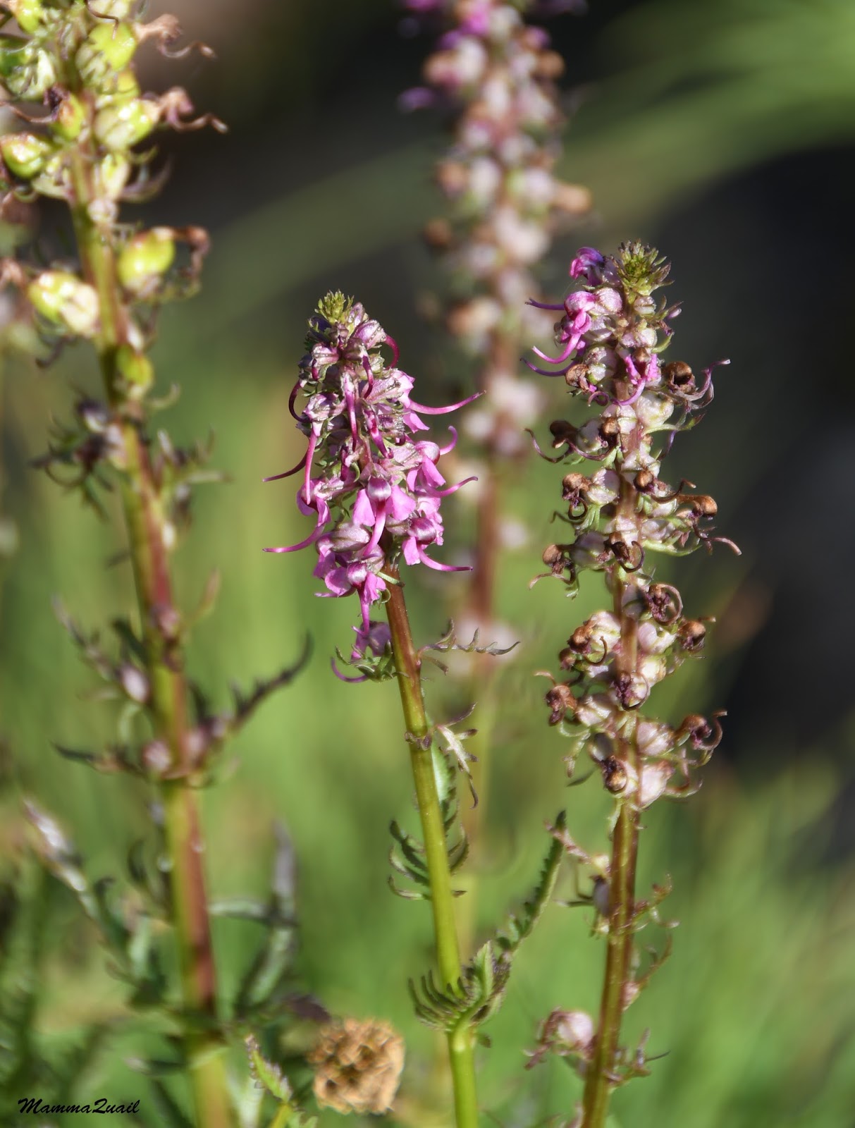
 |
| Elephant Head Lousewort (Pedicularis groenlandica) near Spring Lake |
The north area of Spring Lake basin has a smaller, somewhat isolated lake that was separated from the main lake by a large bog and a low sediment hill. Flowers were in abundance, and birds were flying low over the ground and chirping happily all around us. We saw a deer grazing in the willow bushes by the lake. We walked down to the water and rinsed our hands and faces. The sun was hanging low now, its long rays of light skipping on the lake's camp surface.
 |
| Evening at Spring Lake |
We had our dinner and sat down on the rock ledge to watch the sunset. As in Monarch Lake, the fish started jumping in the lake below, performing their evening dance. The deer came nearby - a doe, skinny and curious. I wondered if she expected us to feed her (not that there was any danger of that). She walked to and fro, and then went into the willows near us and started munching there. It was already too dark by then so I didn't photograph her at that time.
 |
| Sunset at Spring Lake |
It was a calm and beautiful sunset. The place was working its magic on us and we both fell quickly under its powerful spell. We had already agreed that we'd stay the following night too at Spring Lake and dedicate the day to exploring the area more, without our backpacks. We chatted in soft voices, processing our day's experience. My friend was worried that I'd be upset at not fulfilling the original plan but the only thing that bothered me was my negligence to verify our location during the hike. As for the location change - I was perfectly happy where we ended up at. It was the most beautiful and peaceful place I'd been at in a very long while.
The last light slowly faded, painting the granite peaks with pale orange, and finally departing softly, as if with a goodnight kiss.
 |
| Last Sunlight |
We remained sitting outside for about an hour longer huddled in our sweaters, watching the stars pop out one by one, checking out constellations, and listening to the soft sounds of the night. Then it got colder and the fatigue took hold of us. We went into the tent and settled for the night. This night I slept like a log.
Many thanks to members of the California Native Plants Society for their help in identifying plants!
A link to the post about the third day of this trip.


This is a beautiful place - I guess the whole area s beautiful, no matter where you go. Still the mitake is a little frightening.
ReplyDeleteIt's an amazing place. And it takes all that effort to get there. I don't think I'd enjoy it as much had I been dropped there by a helicopter. There is something very spiritual about the pristine wilderness of a high mountain range. And you're right - it is worrisome to think that I was so negligent as to never check my location throughout the day. But we didn't stray far, we were rewarded beyond measure, and I learned my lesson. (I wish all my lessons in life would be learned in such a beautiful manner :-) )
Delete