
 |
| Named after an old Mormon encampment: Mormon Rocks |
Date: November 23, 2016
Place: Mormon Rocks Fire Station, Phelan, California
Coordinates: 34.316742, -117.502256
Length: 1.2 miles
Level: Moderate
A day after our fabulous hike in Bolsa Chica Ecological Reserve we said goodbye to our friends and started northeast on the road to Death Valley.
For a good part of the morning we were crawling on I-15 with all the mass of humanity that was migrating out of the larger LA area before Thanksgiving. We needed a break from driving, a place to stop and stretch out and a short online search came up with a little place in the San Gabriel Mountains called Mormon Rocks.
Mormon Rocks is a small area of San Bernardino National Forest on Hwy 178, about 1.5 miles from Cajon Pass. The short loop trail begins (and ends) at a local fire station that other than two picnic tables on the adjacent lawn has no other public-accessible facilities such as restrooms or a faucet for drinking water.
We found the place without difficulty, got the cameras out of the car and went on our hike.

The Mormon Rocks could not be mistaken - huge lumps of wind-rounded white sandstone protruded from the earth, standing out against the dark landscape.
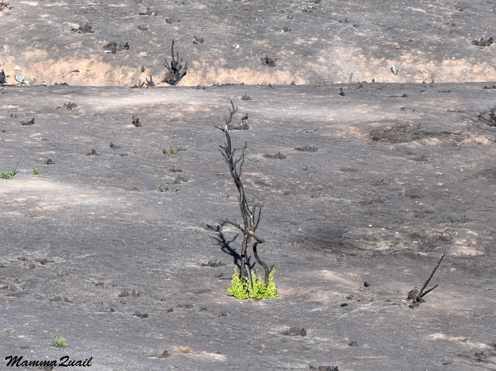
From the first look we realized that something was wrong. Everywhere our eyes could see the landscape was black, save for the sandstone rocks. It looked like every living thing in the surroundings had been incinerated to ashes. As it happened, we were there shortly after a large wildfire had devastated the entire area.
 |
| Blue Cut Fire aftermath |
This is (or was) a chaparral dominated area. The charred remains of the bushes were the only testimony for what must have been a thick vegetation cover.

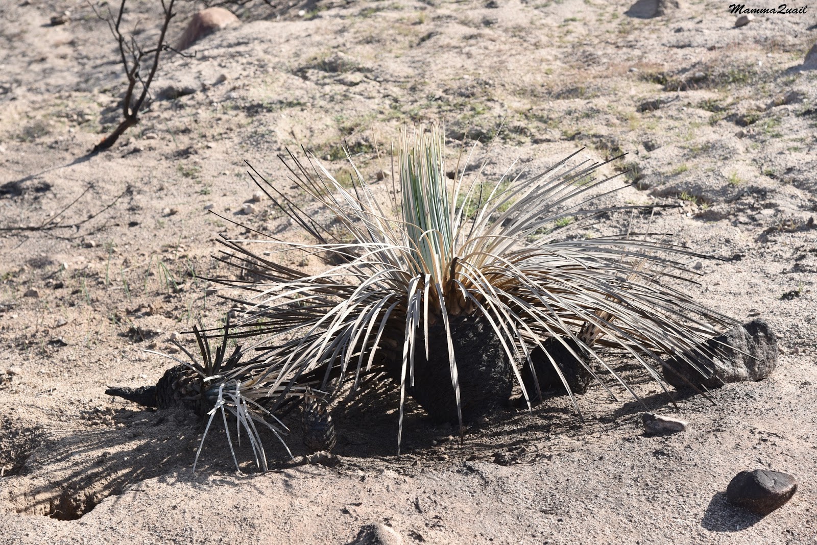
The yucca was a more visible survivor. Charred pineapple-like ovals protruded from the powdery soil, with light green tufts of blade leaves in their center. A core yet lining from which the plant will regrow.
 |
| Chaparral Yucca, Hesperoyucca whipplei |
 |
| Dark-eyed Junco |
 |
| Cassin's Kingbird |
 |
| Stork's Bill |

There was no one there we could ask, and nowhere a posted sign with information about the fire. I've done some research in preparation for this post and found out that less than two months before our visit there the area has been devastated by the Blue Cut Fire, which burned over 20,000 acres.
I though it ironic that this fire raged right by the local fire station. From the ridge we had a good view of the fire station area where we had begun the hike. We also had a nice view across Hwy 178 and of the rocks on the other side.
 |
| Cajon Pass Fire Station |

The trail now followed the ridge. Soon it became apparent that there wasn't just one trail, but many makeshift ones that looked as much used as what would be the official trail, and we could only guess which one was that. So we simply followed the one that seemed to lead us in the straightest path to the rocks.
All that time I kept looking around for more signs of recovery. They were there, but still small. At the very beginning.

Then, as we came across a minor hill crest, I saw a patch of green to the south. It was mature chaparral! That patch of chaparral was the only surviving area that escaped the fire. I could see the reddish-brown rim of dead vegetation that died just before the fire did.
 |
| Surviving Chaparral |

The trail we were walking on got really, really narrow. Moreover, we were walking at times right on the blade of the ridge. While Pappa Quail and the elder chika were making fast progress, the younger chika had some difficulty transversing this terrain so I held her hand and we walked slowly, step by step, until she was once again sure of her footing.

The slow pace allowed me to take a longer look at the new growth. It appeared that the fresh green grass was growing in small bunches, at small ripples of the hillside caused by the now dead old vegetation.

After some slow, careful treading, younger chika and I were making a still slow descent to the big group of Mormon Rocks.

It was a beautiful day, but windy. A coulee of ravens were circling the sky over the highest rock. Occasionally they landed on it, then took off to the air once again.
 |
| Ravens over Mormon Rock |
 |
| Mormon Rock |

I came back to the trail, helped my chika back on her feet and we resumed our descent to the valley and the fire station below.
 |
| Dead manzanita and survivor yucca |
It was there that area that Pappa Quail saw another bit of life in a mostly dead area.
 |
| Yellow-rumped Warbler |
This new growth really cheered me up. I wonder how this area look like right now, after a good rainy season and a few more months to recover.
 |
| Recovery |
When he saw me, Pappa Quail told me that that as he got the stove and food out of the car the camera dropped out through the opened back door and crashed in a fashion that broke both camera and lens. As he told me that he picked up the remains and tossed them into the large waste container at the end of the parking lot (after getting the memory cards out, of course).
"There goes the rest of the trip," he said. " There won't be any birds anyway in Death Valley," he added.
We had a very quiet lunch.
 |
| Chaparral Yucca, Hesperoyucca whipplei |
A sad hke with some hpe for the future (for new plants and new camera...)
ReplyDeleteit's ironic that everything was burned so close to the fire station
Yes, things did go uphill from then on :-)
Delete