Date: May 25, 2019
Place: Henry W. Coe State Park, Morgan Hill, California
Coordinates: 37.186638, -121.546984
Length: 7 miles
Level: Strenuous
Day 1
This backpacking trip had its roots in a request from one of the fathers in my family hiking group about two years ago. He wished to get his family into backpacking and start it with guidance and company for the kids. We had a few discussions before settling on a date that would fit a simple two-nighter for just are two families. It was quicker to decide on the destination - by the time we were good on the date everything that needed prior reservation was already reserved. At Henry W. Coe State Park however, wilderness permits are sold on a first come first served basis. Still, by the time we arrived there on Saturday morning (and we arrived early!) it was just in time to get the last parking spot. And as I entered the visitor office I heard the docent selling the last wilderness permit for the area I had planned for us to go to.
 |
| A funnel spider along the Manzanita Point Trail |
After a short discussion of our group's capabilities we acquired a permit for the Blue Ridge Zone past the Shafer Corral, which is 7 miles away from the Coe Headquarters where our trailhead was. It would be the longest lag we've ever backpacked with the chikas and it would be the first for our friend's kids, but everyone was gang-ho and ready to go. We got our backpacks ready and started down the Corral Trail.
 |
| White Globe Lily, Calochortus albus |
Manzanita Point Trail is the major trail leading from the park's headquarters and out into the wilderness. Seeing how full the parking lot and the headquarters were I expected to see many people on the trail with us. There were other people alright, but not as many as I thought. The park is big and although we were passed by others every now and then, we were alone most of the time.
 |
| Dense-flowered Lupine, Lupinus microcarpus var. densiflorus |
The Corral Trail meets Manzanita Point Road which leads on to the Manzanita Point group camps area. I have
already written about this trail when I did it as part of a day hike loop to China Hole and back. It's an easy, beautiful trail with sweeping views and rich flora, much of it was in bloom. The weather was fair - perfect temperatures for backpacking and mostly sunny. Every now and then however, a large gray cloud would float over us, temporarily darkening the sky.
 |
| A dead old oak turned woodpecker home and granary |
We came upon an already familiar landmark in the shape of an old dead oak tree and took a short break there, to drink water and adjust the backpacks. For our friends it was an opportunity to shift the load a bit from children to adults, as usually happen on first time family backpacking before everyone's learn their abilities and limitations.
For Pappa Quail it was an opportunity to look at the acorn woodpeckers that were busy on that landmark tree.
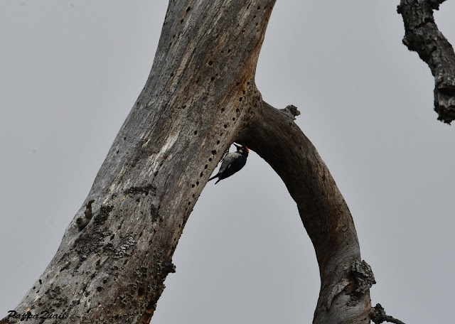 |
| Acorn Woodpecker |
At that place where we took our break the narrow foot trail connects with the dirt road that was once in service of the Coe Ranch and now serves camper groups at Manzanita Point. The landscape along this road is truly the most representative of the Diablo Range beauty.
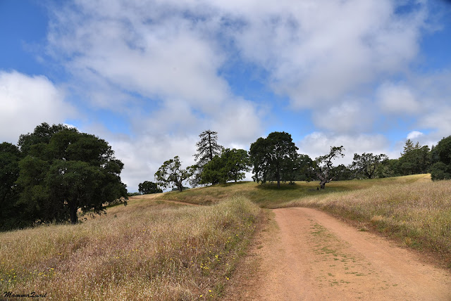 |
| Manzanita Point Road |
We passed by the little pond just before the group camp area. When our little company decided on a snack break it would have been the ideal place to stop at, but they chose to stop at one of the camp sites and eat at the convenience of the available picnic tables. We ate at our leisure and no one hurried to suggest moving again. In perfect timing, the people who were to camp at that site had arrived and so we promptly repacked our food and vacated the site.
 |
| Bass Pond |
Up on the exposed hill bloomed the third wave of spring flowers, among them the larkspur, its blue flowers standing out against the light-green turning beige backdrop of the wild oats.
 |
| Larkspur, Delphinium sp. |
At Manzanita Point we turned onto the trail downhill. In the past I had walked that trail all the way down to China Hole. This time however, we would take another turn, crossing the Coyote Creek at Poverty Flat.
There, just below Manzanita Point, I saw the one flower I was really hoping to see - the ground iris. This gorgeous, deep purple flower grows really close to the ground and is easy to miss, hidden in the tall weeds. There were a quite a few irises in that spot but I couldn't linger there for too long because everyone else were already dashing away letting gravity pull them and their weight downhill.
 |
| Ground iris, Iris macrosiphon |
Close to Manzanita Point the trail cut through a forest of low madrone and oaks and high manzanitas. Further down, the low forest transitioned into a high chaparral composed of mainly chamise and yerba santa.
For the most time, the chaparral was so high that it blocked all view but every now and then there would be an opening and I could take in the vastness of the Coe Wilderness stretching to the horizon, and the deep depression below that was the path of the Coyote Creek.
Below the chaparral the slope vegetation changed into an oak savannah. Different wildflowers adorned this part of the trail. Some were small and delicate, like the bird's eye gilia.
 |
| Bird's Eyes, Gilia tricolor |
Others were large and magnificent, like the yellow mariposa lily. I expected to see these marvelous lilies on the steep slope, I've seen them before in similar areas in the park. They sure were there, at peak bloom, and butterflies and other insects were having a lily pollen feast.
 |
| Yellow Mariposa Lily, Calochortus luteus and a checkerspot butterfly |
We came upon a segment of the trail that went through a deep crevice in the slope. Some water must have still been flowing there because the vegetation was really dense and looked more riparian than oak savannah. One confirmation of that popped in the form of a piperia orchid. It was slender and its flowers small and green, but an orchid is always royalty amongst wildflowers.
 |
| Alaska Piperia, Piperia unalascensis |
The elder chika found another creek life - a toad! To my chagrin the toad was in her hand when I caught up with everyone after appreciating the orchid. I ordered her to let the poor amphibian go. They should not be handled, it harms them.
 |
| Toad |
We were getting close to Poverty Flat at Coyote Creek. Once again we were mostly under the trees, and now in dense riparian (creekside) vegetation. In the coastal region this mean also lots of poison oak.
Third wave spring bloom has many geophytes (bulbous plants) - lilies, irises, brodiaes, and onions too. Wild onions have very pretty bloom.
 |
| Jeweled Onion, Allium serra, and leaves of poison oak |
Clarkias were on the decline during our trip there but there were still plenty of flowers open on the grassy, sun-exposed patches of the slope.
 |
| Purple Clarkia, Clarkia purpurea |
It's a good 4.5 miles hike from the Coe headquarters down to Poverty Flat where we had met Coyote Creek. Although most of the trail is downhill we were all are than ready to have a good, long break. We crossed the creek, found a yet unoccupied campsite and settled under the shade of an oak tree to rest and have lunch.
 |
| Coyote Creek |
No one disturbed our peaceful siesta. We ate, chatted, and rested. Pappa Quail also looked for birds and fond them.
 |
| Blue-gray Gnatcatcher |
Poverty Flat was the place where I originally planned for us to camp, but it was all booked when it was my turn at the permits desk so after a good long break I had to push everyone back on their feet. We had 2.5 more miles to go, over the Blue Ridge.
It was still early in the afternoon but now we were moving sluggishly. It wasn't too hot but with the heavy backpacks and the steep grade of Poverty Flat Road which we were walking on slowed us down to a near crawl. Good thing there were many wildflowers around to brighten my mood.
 |
Western Larkspur, Delphinium hesperium
|
When I had to alter my originally planned route to a more distant one I discussed various options with the docent. When settling on going to Shafer Corral my first idea was to go down to China Hole and follow the Narrows trail. The docent however, had informed me that there's no passing through The Narrows without wading in the water. It was then that I opted to take our families down to Poverty Flats and then up the Poverty Flat Road.
 |
| Poverty Flat Road |
If we were to go through The Narrows and get our feet wet it should be on our way back when wet shoes would no longer be an issue, I reasoned.
Anyhow, by the time we were sweating buckets up Poverty Flat Road I thought how nice it would have been to walk in the water. that trail would have been almost level too.
 |
| Poverty Flat Road |
We had to stop to rest about three quarters of the way up. We sat in the patchy shade that the thin oaks cast on the trail, making sure to check the area first for ticks. Between the oak trees were some coulter pines. They are beautiful trees but not very good shaders.
 |
| Coulter Pine, pines coulterii |
Time started pressing and we had to get going again. The younger children had a hard time carrying their load uphill and some more weight was redistributed in the adult direction, making the load harder for the adults as well.
 |
| Ithuriel's Spear, Triteleia laxa |
Other the trees and the blooming geophyts there was very little greenery on the sun-exposed hillside. Nearly all the vegetation between the trees was drying grasses. I was very pleased therefore, to see some lovely green ferns in a nook in the slope.
A small brown bird hopped on the trail ahead of us. Pappa Quail and the elder chika moved forward with renewed energies. My chika chose to not bring her birding camera (it's heavy!) but Pappa Quail was properly equipped and he followed the bird as it explored a patch of dirt on the trail and then flew back to its perch on a low oak branch.
 |
| Ash-throated Flycatcher |
At last we reached the hill crest and the dirt road curved north on the Blue Ridge. Between us and the next mountain ridge was the deep valley of the south fork of Coyote Creek. Shafer Corral would be down to the left but I couldn't see it, or the creek itself. The valley floor was hidden behind the curve of the hill we were on and I wasn't able to tell if the creek was even running. The docent had told us that there should be water in the creek but I would have loved to see it myself, now that our bottles were near empty.

We were walking some distance along the dirt road without seeing the turn to Shafer Corral Road that was marked on the map I carried. I slowed down, then stopped altogether. Then I yelled to the people on the lead to stop. They started to come back but I yelled to them to stay put until I figured things out. I walked back and forth passing a couple of time the trail segment where the turn should have been according to the map. It seemed as if there should be a trail there, but the weeds had grown all over it. I told the people nearest me that I was going to check it out and that they all should wait. Beating the weeds before me with the hiking poles (I feared rattle snakes) I plunged into the savannah grass and moved carefully over the crest until ... there it was! faint and overgrown, and certainly not looking like a vehicle road, but definitely a trail! I went back and motioned everyone to follow me. They were sceptic, but nearing exhaustion they were too tired to argue and followed me over the hill crest and downhill.

I admit I had some doubts. The faint underused and unmaintained trail was hard to follow and I did have some guesswork here and there. But I knew the direction was correct and that simply going in that direction would get us to our planned camping site. And even if it didn't, it will get us to *a* camping site. I just hoped that there would be accessible water there.
It cheered me up to see mariposa lilies along the path. They're always a pleasure to see.
 |
| Clay Mariposa Lily, Calochortus argillosus |
Pappa Quail didn't say much. He was focused on keeping the chikas from reaching their breaking point. They actually did quite good - I guess the presence of younger children there prompted them to keep cool. Anyway, Pappa Quail also found reasons to keep his cool.
 |
| Lesser Goldfinch |
After objectively few minutes and subjectively an eon I finally had a clear view down at the south fork of Coyote Creek and my heart skipped a bit - the creek was running! There was water in the creak. Plenty of water. And the trail down lay visible before me, without any apparent obstacles. With renewed spirits I increased my gait and everyone followed me down to the water.
It took us longer than expected to find a suitable camp site. The best spots were already taken - I was a bit bummed to find other campers there but I guess that wasn't too surprising. The spot we eventually chose was too close to the trail to my taste, but it was flat and clean of rocks and thorns and clearly was used several times recently and I didn't want to break new ground. It was already getting late and everyone was tired.
 |
| Coyote Creek, south fork. |
We built our little camp and cooked dinner. Then the sun set and within minutes after dark we were all inside the tents, resting after a long and full day.
 |
| Sunset |
Usually I am the last of my family to enter the sack. The chikas retired first with Pappa Quail close after them while I remained to wash the few dishes we used and to filter more drinking water. Our friends too had gone to bed and I was left by myself to relax and contemplate. I knew that tomorrow might bring rain and before getting ready to go to sleep I covered the backpacks and secured the cameras inside the tent's vestibule. I thought that after the long wet season we've had it was ok to hope that tomorrow's rain wouldn't be too much.
Many thanks to members of the California Native Plants Society for their help in identifying plants!


This is a beautiful place, but the trip seems to be quite challenging.
ReplyDeleteThe yellow maroiposa lily with the butterfly picture is great!
Thank you :-) The first day was indeed challenging - it was the longest stretch the chikas did on a backpacking trip and for the first timer kids that was quite an achievement! And it was well worth it :-)
Deletelooks like my kind of trail... 3 Calochortus species, Iris, delphinium and an Orchid? with the lovely oaks and coulter pines - simply a perfect trail.
ReplyDeleteOh, you would have loved that trail! Next visit!
Delete