
 |
| Tahquitz Peak |
Date: November 21, 2023
Place: Idyllwild Park, Idyllwild, California
Coordinates: 33.743780, -116.722868
Length: 2.8 miles
Level: moderate
Place: Idyllwild Park, Idyllwild, California
Coordinates: 33.743780, -116.722868
Length: 2.8 miles
Level: moderate
Last Thanksgiving break gave us a chance to go on another family road trip like we used to do a lot when the chikas were little. Pappa Quail and I discussed a few directions and since I really didn't want to fly and Pappa Qusail didn't want to drive very far (relatively), we chose to go to the desert of Southern California. Pappa Quail wanted to see the Salton Sea again, and also Anza Borrego State Park, which he has not been to since the winter of 2012. I, on the other hand wanted to see some new places, and since Idyllwild had been on my wanna go there list for some time, I scheduled some time in that area. The first hike we did on this trip was in Idyllwild Park.

Idyllwild is situated up Mount San Jacinto. The late November night we were there was very cold and the morning was chilly. When we got to the park however, the sun had already broke the chill and the morning was warming up rapidly. I looked at the provided map on the kiosk, selected a loop trail rthat seemed nice, and we set out on our hike.
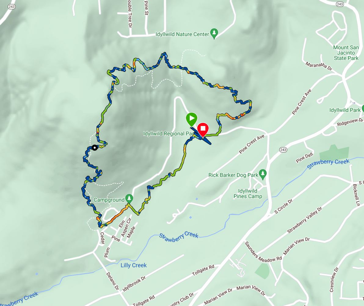 |
| Our hike as captured by my GPS |
The trail started in an open meadow but soon after it delved into the woods. We crossed a little creek. The crossing place was dry but there was some water still in a small water hole between the rocks.
 |
| Creek crossing |
The water hole was in deep shade. Fallen oak leaves floated motionlessly on the surface. Only a few rays of sunshine filtered through the trees and hit the water, shining back from the surface, creating a dazzling light pattern.
 |
| Water Hole |
Across the creek we continued along a narrow foot path. On the right side there was the park's campground. On the left, a row of yellowing willows blocked the view of the houses' backyards that reached the park fence.
 |
| Trail |
Past the neighborhood we reached a trail junction and turned right, northward, and immediately started ascending, mildly at first.
 |
| Trail |
Unusually looking trees always attract my attention, and old oak trees tend to have that gnarly, strange looks. There was one of them venerable old oaks up ahead just off the trail.

I had to take a close up. This old oak which had already dropped its leaves, looked like a strange forest spirit.

Manzanita bushes can also develop 'personalities' given the space to grow so. The bush in the photo below had plenty of space around it to grow pretty much in any direction it needed.
 |
| Manzanita, Arctostaphylos sp. |
I didn't expect to see any bloom there this time of year. In fact, everything looked very, in the quiescence of late fall, ready for winter to set in. Still, I found a flower. In inflorescence, more like it.
 |
| Aster |
The trail was becoming steeper. We left most of the oaks below and transcended into a pine-dominated loose forest.

Between the trees were large areas of chaparral, comprised mostly of chamise, mountain mahogany, and manzanita. The trail became narrower too, and we needed to be careful to to get scratched by the trail side vegetation.

There were other bushes and vine-like plants in the chaparral. Many of them were bearing fruit.
 |
| Chaparral Honeysuckle, Lonicera interrupta |
The terrain became rockier and the trail steeper and harder to traverse. On the same time, the day, which started chilly, was now warm bordering on hot. We arrived the sweating stage, and had to pause for breathers and hydration.

On the other hand, being high up meant we were beginning to have some nice views. I'm not sure what is that saddle-looking peak in the photo below but I suspect it is within the San Bernardino mountain range, perhaps San Gorgonio.
 |
| View North |
As usual when we hike as a family, I was bringing up the rear. At some point I lost sight of the others and when I climbed up the next set of rocky steps I realized they all had sat down to rest. There was no space there left for me so I ascended a few steps higher to find a good place to sit for a break.
 |
| Trail |
The view from my sitting place was gorgeous. I could see in three directions far and wide. To the south I saw the wide forest that inhabits the heights of the Santa Rosa and San Jacinto National Monument wilderness area.
 |
| View South |
Adorning that view point was a lovely beargrass plant. It wasn't blooming but still liked like a proud sentinel, guarding the view.
 |
| Parry's Beargrass, Nolina parryi |
Next to me on the other side were some mountain mahogany bushes, laden with their feathery fruit. These 'feathers' help the seeds float away in the wind and be dispersed away from their mother plant.
 |
| Birch-leaf Mountain Mahogany, Cercocarpus betuloides |
Behind the mountain mahogany I had an open view to the east, toward Coachella Valley. We planned to go down there after this hike. Pappa Quail wanted to hike again at the Thousand Palms Preserve, but I wanted to check out new trails in the area. Eventually it was our route that decided - going to Thousand Palms Preserve would have been too long a detour.
 |
| View East |
To the north I had still the view of the saddle-peaked mountain that was visible ever since we cleared the lower oak forest area. Up ahead the trail disappeared around a massive boulder. When we got up to continue our hike I went ahead to check where was the trail leading us.

Going up and around that boulder did take some active hand use. I went up first ahead of my family, but as soon as we cleared the boulder and were on a comfortable trail again I fell behind once more. This time the reason was the manzanita berries - they were fully ripe and very sweet. While everyone else passed me without a pause, I picked handfuls of berries and filled my mouth.

Soon we had other peaks in view - this time to the northeast, and much closer. First we saw the pyramid shaped Tahquiz Peak.
 |
| Tahquitz Peak |
When we cleared the vegetation on the left Mount San Jacinto itself came into view. Last time we were in the area we took the tram from Palm Springs up the mountain. It was on winter break and there was snow up the mountain, and it was very, very cold so we didn't hike that time. Now the mountain was clear of snow and it was a beautiful day, but San Jacinto wasn't on our trip's itinerary. It would be on another trip that I'll go up it again.
 |
| Mount San Jacinto |
We reached the highest part of the hike. The trail leveled off and for some short distance we had a nice, easy walk through a dispersed pine forest. The trees up here were smaller, separated by large boulders. Other hikers that have ascended on the other direction of the loop nodded hello as they passed us on their way down whence we came.

The trail didn't stay level for long. Soon we started descending down an avenue of berry-laden manzanita. The chikas saw me munch on the berries and tried them out as well, but didn't find them as appetizing as I did.

Pappa Quail, who hasn't found many reasons to use his camera so far, found a cute lizard to focus his camera on.

The elder chika had better luck in seeing birds, and for the most, she got better photos of those birds than her father, whose camera was giving him some trouble at the time.
 |
| Anna's Hummingbird |
The trail downhill was considerably steeper and we quickly descended back into the oak woodland. Once seeing the first bird, Pappa Quail and the elder chika kept seeing more. Soon it was no longer me who was holding up our hike.
 |
| Mountain Bluebird |
None of the birds we've seen was a new species to us, what birders call 'a lifer'. Still, they were pretty and lovely to see, or in the case of the acorn woodpeckers - hear them as well.
 |
| Acorn Woodpeckers |
While my family birders focused on the birds and the younger chika focused on doodling on the sandy trail with a stick, I turned my attention to the majestic oak trees that shaded this art of the trail. Thy looked like live oaks - their foliage was green and thick even this late in November, but their leaves were smooth and not serrated like the leaves of the live oaks in the bay Area, and their acorns were very thick.
 |
| Gold Cup Live Oak, Quercus chrysolepis |
Later I received identification for these oaks at the California Native Plants Society. These were gold cup live oaks. They actually to grow in the Bay Area as well, I simply haven't noticed them before, abomgs all the other species of live oaks that grow there.
 |
| Gold Cup Live Oak, Quercus chrysolepis |
There were other ok trees in this park as well - not live oaks which stay green year round, but deciduous oaks which displayed lovely fall colors at the time we were there.

Below, between the fallen oak leaves hid a lizard. I managed to get a few photos of the shy reptile before it run away into hiding.
 |
| Lizard |
We reached the creek again, upstream of the place where we crossed it at first, early on our hike. Here we could see n water, but I could hear a faint trickle hidden in the rocks.

After crossing the creek we were ascending again. The chikas expressed their desire for lunch and Pappa Quail mentioned seeing an ice cream parlor in town, not far from the park. Invigorated by the promise of ice cream, both Pappa Quail and the chikas started striding uphill, leaving me at the taiil again, to enjoy yet another plant that was in denial of the season.
 |
| California Buckwheat, Eriogonum fasciculatum |
Eventually I caught up with the rest of the family. We reached a small clearing from which we could glimpse Tahquitz Peak between the trees.

Across the trail on the other side from the mountain view was a large, funny looking boulder. Any other time I might have tried climbing it. Now I simply took a photo and moved onward.
 |
| Boulder |
We reached the final trail junction of our hike and from there it was pretty much fast pace walking on an almost level trail.
 |
| Trail |
I was still celebrating the fall colors we got to see on this hike when my family have already reached the parking area and waited for me to come along.

We did indeed go to the ice cream parlor after this hike. They had certainly earned it. I wanted to stay longer in the area but the days were already very short and we planned to reach Brawley that night, and squeeze another hike in if we could. I would just have to plan another trip to the area if I want to see more of what Mount San Jacinto has to offer.
Many thanks to members of the California Native Plants Society for their help in identifying plants.


