Showing posts with label Hayward. Show all posts

Wednesday, April 23, 2025

Visiting Ukraina, at Garin Regional Park


Date: March 26, 2025 
Place: Garin Regional Park, Hayward, California
Coordinates: 37.651985, -122.016029
Length: 3.3 miles
Level: easy  
 
Last month I met with a friend of mine, and what a better way for a friendly meeting than a nice hike in the outdoors? For our hike I selected the Ukraina Trail in Garin Regional Park. I've hiked that trail back in 2021 and I thought it would be nice to revisit it. The Ukraina Trail isn't connected with the main trail system in Garin Regional Park. To get to the trailhead we had to drive all around the park and behind Cal State East Bay. There wasn't even a designated parking area there, so we simply parked at the road side and started down the trail. 
Our hike as captured by my GPS

 The first part of the trail was a paved road, too narrow or car traffic and quite wide, to accommodate plenty of hikers and bike riders. 

I was excited to see California poppies by the side of the trail. The poppies were in bloom but the flowers were closed - it was a cloudy and very windy day, and these poppies like the bright sunshine,
California Poppy, Eschscholzia californica

After a short distance of pavement the trail changed into a gravel road. The gravel was well packed and had no potholes or puddles. The clouds raced across the sky and the wind blew at our faces.

I found one poppy that braved the wind and the clouds and was open. I didn't see any insects visiting it, but perhaps it was rewarded later.
California Poppy, Eschscholzia californica

The sky was cloudy but there was no fog below. We had a very nice view to the southwest. My friend asked about the hills at the bay shore. These were Coyote Hills, in Fremont. 
Coyote Hills View

There were more wildflowers along the trail. Miner's lettuce was one of the most common flowers I've seen on that hike. There were carpets of them, mixed in with the grasses.
Miner's Lettuce, Claytonia parviflora

Blue-eyed grass was also blooming. I saw only a few at first, but when I looked further up the slope I could see many more in between the bushes.
Blue-eyed Grass, Sisyrinchium bellum

The trail led us to a grove of eucalyptus trees. Eucalyptus, a native of Australia, was introduced in California in the 19th century and established itself all around the Bay Area, altering forever its forests and wildlife niches.

Behind the eucalyptus grove the view to the west opened up. There we could see the northern peninsula peaks of Montara Mountain.
View West

We reached the first historic part of this area, but neither of us felt like exploring the old and crumbling ranch structures. Nearby was a fence behind which was a very lovely, modern estate that looked very much lived-in. I wondered if the people living there were descendants of the people who worked the old ranch before it became a park.
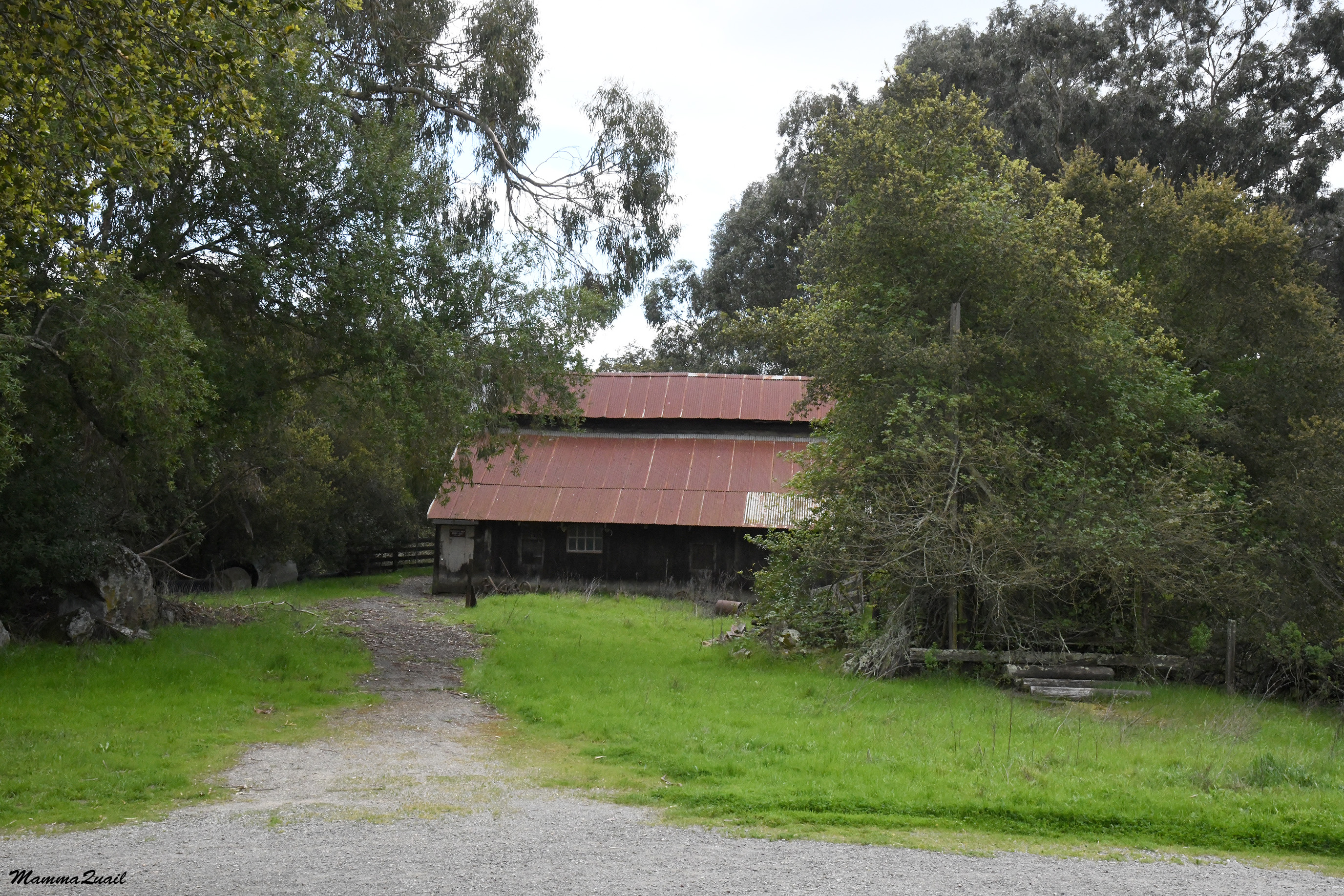
Old Barn

We crossed a little creek that flowed lazily through a pipe below the trail. The willows shadowing the creek were already past their bloom time and were growing their spring foliage.

Behind the creek the trail split and we continued ahead where the Ukraina Trail sign directed us. The trail was now packed dirt, and was flanked on the west by tall eucalyptus and thick oak trees, and on the east with open grassland above which circled a committee of turkey vultures.

In the open grassland, or more like it, in the more exposed areas and the clearings of the grassland, bloomed man primrose plants. They were the most common wildflower on this part of the hike, often covering the trail itself. 
Sun Cup, Taraxia ovata

We got away from the eucalyptus grove and soon the trail delved into a very different grove of trees - the local species combination of oaks and laurels. 
Ukraina Trail

The oaks like growing in rocky places of the round, grassy hills. When oaks sprout and establish themselves in rock cracks they eventually split the rock apart. I've seen the outcome in many places,  and also here, along the Ukraina Trail.

There were a few other wildflowers blooming between the grasses beside the primrose. One of them was the purple sanicle, the same species that I've seen a week before on my backpacking trip in Henry W. Coe State Park
Purple Sanicle, Sanicula bipinnatifada 

We reached the historical landmark area where the orthodox priest Agapius Honcharenko and his wife settled and are now buried. We paused by the state landmark sign to read the information. I don't know what is the significance of the pinecones piled on that sign, if there is any. 

Next to the landmark sign was another information sign telling more about Honcharenko and his work. Apprently we weren't the only ones interested in the sign though - a little spider was crawling in it. 

The historic landmark area was fenced but the gate was open, so we walked in and approached the vista point at the edge of the hill. There was a bench there, and a large pine tree fenced with old wood boards. I figured that the fenced are was the grave site. 

The grave site was marked with two orthodox crosses, similar to those I saw near Fort Ross last year. I assumed that the pine tree grew after the priest and his wife were buried there. Perhaps the cones piled on the landmark sign fell from this pine tree. 

On the wood fence of the grave site were little ornaments and trinkets painted in the colors of the Ukrainian flag. 

My friend and I sat down on the bench. We chatted, snacked, and enjoyed the view. We could see San Francisco from that view point. 
San Francisco View

My friend spotted a bumblebee below us, in the grasses. The bee flew heavily between the few stork's bill flowers that bloomed there. Stork's bill are highly invasive plants but the bee didn't discriminate. Besides, there weren't many other options nearby at the time. 
Bumblebee

My friend also asked about the far away trail that run along the exposed green hills before the big drop to the city below. The city was Hayward, of course, and those hills were the more accessible and certainly more visited part of Garin Regional Park. 
Hayward View

After a while it was time to get going again. The wind was still pretty strong and chilly, but the clouds separated and we were treated to lovely sunshine. 
Ukraina Trail

We continued south after exiting the historical landmark area, on the Ukraina Trail loop. I identified some more wildflowers in the grasses, such as the miniature lupine. 
Miniature Lupine, Lupinus bicolor

A few oaks decorated the ridge top but for the most part the hills were exposed to the elements, covered with only open grassland, like the soft down that covers newborn babies' skin. 
Ukraina Trail

There were lots of mushrooms in the grass. Occasionally I stopped and took a photo, but for the most part I settled for simply pointing them out. They all looked very fresh, as if sprouted right after the most recent rains. 

My friend pointed out to me a long straight line of rocks and asked if they were the remains of a human-made hedge. I pondered her question - these certainly could have been the remains of a human-made structure. Roughly constructed stone hedges were a common practice in the old world farms. 

Most of the rocks we've seen looked completely naturally placed, though. And there were little clamps of poppies around and between the rocks, too.  
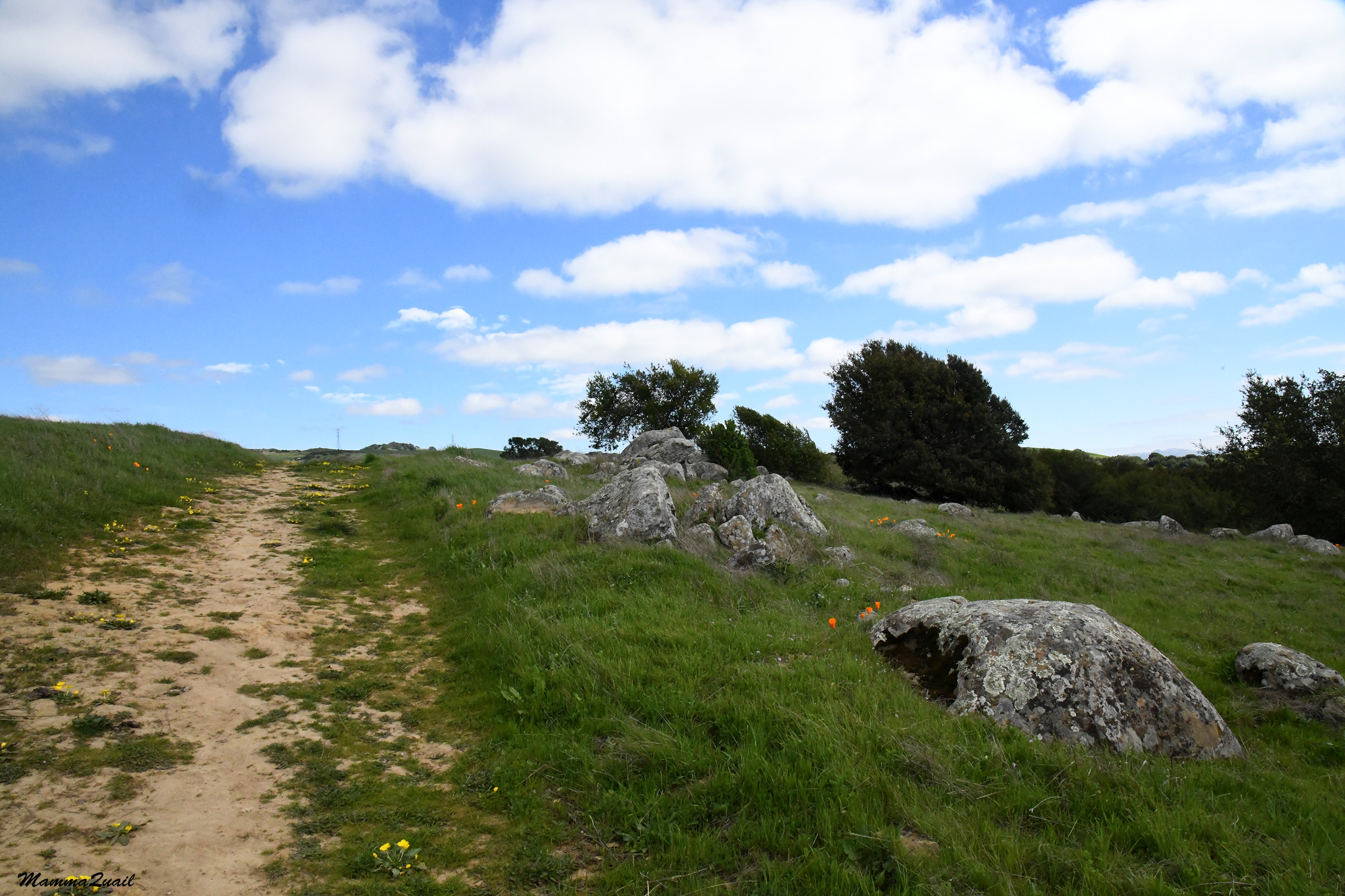
The trail curved east and then north. Suddenly my friend exclaimed - she nearly stepped on a snake that was lying across the trail. The snake was motionless and my friend thought it might be dead. When I approached the animal I saw that it was a little garter snake, and that it was definitely alive. I took a few photos with my camera and moved away. A few steps further I thought it would be nice to take a photo with my phone too but when I returned to where the snake was, I saw it slithering into the grass at the edge of the trail. 
Garter Snake

From the easter side of the Ukraina Loop Trail we had a wonderful view of the wide plateau that was the height of the coastal range in this area. With the fluffy white clouds and the rocks below the view reminded me of a Georgia O'Keefe painting. 

More mushrooms in the grass seasoned our hike. My friend and I had a good time and we were catching up with each other on a number of topics. 

For some distance the trail neared a fence that marked the park's boundary. Looking ahead I thouight I saw a slight movement. I stopped and looked through my camera lens. Sure enough - there was an animal - a rabbit - in the grass close to the bushes by the fence. 

We approached slowly, little by little, taking photos with each step. Eventually the rabbit did run off to the bushes. The photo of the bunny running was the best of my rabbit photo series. 
Cottontail Rabbit

A few steps later we found more mushrooms. These mushrooms were growing on the best possible nutrition a mushroom can have - a good size cow pie. 

A small puddle remained from the most recent rains. The puddle shone like a little jewel embedded in the grass, reflecting the sky. Thankfully it wasn't warm enough yet for mosquitoes. 

We followed the trail onward to the north. On the horizon on the northeast were large, beautiful houses. The houses looked relatively new. The city was growing on the expense of the open farmland. The farmland too, was worked where was wilderness before. At leased the parks were keeping open spaces from the urban sprawl. 
Ukraina Trail

We completed the Ukraina Loop Trail. The way back was the same we came in on - that packed gravel trail that cut through the old farm area. 

A few dark-eyed juncos foraged on the trail before us. With some patience and with the unexpected cooperation I got a nice photo of one of these little, hyperactive birds. 
Dark-eyed Junco

The rest of the hike passed quickly. The wind never ceased blowing, neither did it ease, and the clouds were returning. Both of us were sorry that the hike was over so quickly, so we decided to go on another trail at the Hayward Shorline. 

I did note that the poppies that were closed at the beginning of our hike were now open. That hour of sunlight must have convinced the poppies to open up. 
California Poppy, Eschscholzia californica

Ukraina Trail was a lovely, easy hike in a very peaceful part of Garin Park, away from all the city hassle. It was certainly worth the round about drive to get there, and I hope to check it out again in the future. 


Wednesday, December 20, 2017

Tide Low, Tide High, Birds Eat, Birds Fly. A Day Overcast and A Day of Sun. Two Days of Hiking and Birding Fun, at the Hayward Regional Shoreline


Dates: December 2 and 3, 2017
Place: Hayward Regional Shoreline, Hayward, California
Address: 3010 W. Winton Ave, Hayward, California
Length: 3.2 miles
level: easy

The Hayward Shoreline had been a regular hangout for us Quails when we lived nearby and I still miss going there on a regular basis. Last week I solidified a tentative plan I had to take my family hiking group there on Sunday and since it has been a few months since my last visit, I decided to go there on the Saturday before.
On Saturday morning as I was getting ready Pappa Quail and the younger chika said they'll join me.
Surprisingly, the elder chika decided to stay behind.
The sight that welcomed us at the parking lot was very similar to what we saw when I was there for the 4-H hike a couple of years ago - a puddle of rain water on the road and a gaggle of geese using it as a water hole.
Canada Geese gather for a drink. Dec. 2
California ground squirrels are plenty there. Not that t's difficult to see or photograph hem, but they're so common that we hardly bother with it anymore. Still, they are very cute to watch and usually also very cooperative photo models. I was surprised to see how many of them live between the boulders right at the water line - a precarious home choose considering the long reach of the bay water.
California Ground Squirrel, Dec. 3
We entered the Shoreline from the W.Winton gate intending to hike south along the Gogswell Marsh and finish at the Hayward Shoreline Interpretive Center. I had left my bike at the Interpretive Center to get back to my car when we'd finished the hike.
Our hike as captured by Pappa Quail's GPS on Dec. 2.
The bay waterfront never gets snow, but the thick layer of Coyote Brush seeds can give the impression some times.
Coyote Brush, Dec. 2
And even as late in season as December, something will always be blooming along the coast. And most often the blooming plant would be of the aster family.
Gumweed, Dec. 2
We walked along the slough toward the Bay waterfront. Great egrets are permanent residents of the Hayward Shoreline and are sure to be seen there, usually nearby a great blue heron.
Great Egret, Dec. 2
We hardly ever note the presence of mallards anymore, since they seem to be everywhere. But Pappa Quail did photograph this pretty drake, saying he looked very cute. 
Mallard drake, Dec. 2
Saturday was gray and overcast but Sunday was clear and beautiful. We had a terrific view all around and a nice, clear view of San Francisco across the bay. 
View of San Francisco and Mount Tamalpeis, Dec. 3
While we didn't have that great view on Saturday, we did get to see many, many birds. Most of them - shorebirds. And most shorebirds look very much the same to me. There are some, however, that are quite distinct and easy to identify. The curlew is one of these species, and it is almost certain to see them any day in the Hayward Shoreline.
Curlew, Dec. 2
The greater yellowlegs is also a fairly common shorebirds but I am never sure about its identity unless I see its legs. And even then it could be mistaken, if its legs are too muddy to show the if yellow color. Thankfully there are two real birders in my family, and I leave the identification to them.
Yellowlegs
And some bird I identify by default. A quarter of a mile south of the canal mouth the trail curves back inland along a second canal. There at bank of the second canal bloomed a tobacco bush. That tobacco is a non-native species and I didn't pay attention to it on Saturday. On Sunday however, I did photograph ot. It looked pretty n the sunshine, but the main reason was the little Anna's hummingbird that was feeding from its long, tubular flowers. I knew it was Anna's because it is the only hummingbird series that overwinters in the Bay Area.
Anna's Hummingbird feeding on Nicotiana glauca, Dec. 3
That trail segment leads back inland along a low and flat hill. Low and flat, and dry land with drylands vegetation, that is home to many little bush birds. 
White-crowned sparrow, juvenile, Dec. 2
Pappa Quail made sure none of this little brown birds escaped his camera. He also took the time and effort to identify them. I don't think I could have.
Golden-crowned Sparrow, juvenile
Past the low hill the trail turns back south and takes right through the wetlands. On a levee at first and then on a long overpass.
The wetland is being taken over by an aggressive non-native cordgrass that chokes the native pickleweed. There is much concern about this but I'm not sure what will be or can be done about it.
Cordgrass, Dec. 3 
When I hiked there with my hiking group on Sunday, as we walked along that part of the trail a large gaggle of Canada geese that were on top of that hill suddenly took to the air in a big commotion. It didn't take long to see what had startled them - a  glider parachute hovered behind the birds. It must have looked like a huge raptor to them.
Glider and geese
Much of the Shoreline trail is on levees that used to hold the salt pond of Cargill Corporation. Many of these salt ponds were made nature preserves and sone were converted back into sat marshes. The conversion involves the breaching of the levees and allowing bay water to flood the wetlands with the tide cycle.

At the time of our family hike there in Saturday the tide was low. Very, very low. The little cove that opened up when the levee was breached was a wide mudflat with just a trickle of water on its side. The mudflat was covered with shorebirds of different species. They were all busy feeding - poking the mud for the mollusks and crustaceans that leave there.
Feeding Grounds
Papp Quail took close up photos of the feasting birds. They were of the usual crowd that flocks to the low tide mud exposed: sandpipers and other little shorebirds.
Dunlin
The dunlins were the bigger in this flock, and they were mostly stationary, methodically feeding at the same spot of their choice.
The smaller sandpipers foraged more and kept moving around, poking the mud here and there, then moving on to a different spot to poke some more.
Least Sandpiper
The sandpiper movement between the dunlins gave the mud flat a constant shimmer and shine that was very pleasing to see.
Western Sandpipers
In the fringes of the feeding flock foraged a few bigger birds. Not part of the flock but keeping a close distance to it. 
Willet
The bridge over the levee breach is long and as is very common, we saw anglers sitting there with their lines in the water. The west of the bridge on the bay side also showed exposed mud flats extending quite far into the bay. This particular corner seems devoid of birds but the image is cropped - there were quite a few shorebirds poking in the mud to the left of the image.
Exposed mudflats, Dec. 2
A cloud of small birds circled the water, then came together into a long thin line formation close over the water surface and flew north.
Traffic on Sandpiper Lane, Dec. 2
While I was looking toward the bay Pappa Quail focused on the birds feeding in the mud.
American Avocet, Dec. 2
While all the birds we saw that day were the same old crowd we were quite familiar with but it was cool to see them feeding and sometimes squabbling. Pappa Quail got some very nice behavior shots of the feeding birds.
Curlew eating fish, Dec. 2
And there was much food to go around. Fish and crabs and everything else mud-living that thrives so well in the SF Bay tidal zone.
Willet eating crab, Dec. 2
I wonder where all of these birds go when the tide is high ...
Marbled Godwit
A jogger came by from behind and past us. All the birds that were feeding down at the cove not minding us or the angles took flight. A cloud of birds of at least three different species, all moving in unison, their wings shimmer in the faint sunlight, shadowing the shiny mirror-like mud below.
Dec. 2
I followed the cloud of birds as it murmurated to and fro, eventually flowing over and across the bridge and settling on the mudflats on the bay side and resume their feeding.
Dec. 2
The cove, previously teaming with the foraging shorebirds was now empty, displaying only the thin trickle of water extending from the salt marsh to the bay.
Dec. 2
Quite a striking contrast with how the exact same place looked like on the following day, at the peak of high tide.
Dec. 3
The high tide on Sunday, December 3, wasn't any regular high tide but a king tide, when the water rise particularly high due to the combined gravitational pull of moon and sun. The sight of the multitude of birds were not there of course but we were duly impressed by the beauty of the flooded salt marshes and coves.
There are very few spots along the trail where it is convenient to just sit and relax. One such point is at the edge of the former levee past the long bridge over pass where there are makeshift (and nor very stable) benches and a very nice view of the bay. When I was there with my hiking group the wind was blowing strong and cold so we didn't stay there for too long.
Dec. 3
Going on southward and closer to the San Mateo Bridge the trail splits. The left turn leads east and back north to complete a loop around the salt marsh. That loop I hiked a couple of years back with the Redwood 4-H Hiking Project. Now we were continuing on south to the Hayward Shoreline Interpretive Center.
There too on Saturday the birds filled the low tide -exposed mudflats. The mud shone and flickered in the sun that was already setting at the time.
Between the Salt Water and the Sea Strand, Dec. 2
On my hike there on Sunday everything was flooded and the water sparkled blue under the bright early afternoon sun, complementing very nicely the reddish pickleweed.
Dec. 3
Salt marshes play a very important role in the Bay's ecology. One of its functions is the purification of water, done naturally by microorganisms that live in the mud. East of the salt marsh is the City of Hayward Wastewater Treatment Facility where the city's wastewater is cleaned to a point it can be released back into nature, making its way back into the bay.
Hayward Wastewater Treatment Facility, Dec. 3
The trail leads south along the shoreline for almost a mile past the overpass bridge. Then it curves back east and inland, a slough on the north and SR 92 on the south, with a narrow canal and another field of pickleweed in between.
The tide was already coming in when Pappa Quail, younger chika and I made it around the curve and over the little bridge across the slough. It was cloudy, and getting near twilight time.
The slough, Dec. 2
That bridge is where cliff swallows build their nests in springtime. There were no nests there this time of course (I did check!).
On the following day the tide was receding when me and my hiking group arrived to the same place.
Dec. 3
The sun was shining bright still and the current going out to the bay was strong. Little shorebirds were already appearing at the narrow, newly exposed strip of mud at the slough banks.
Receding Tide. Dec. 3
While we didn't see any swallows nests there that weekend, there were warblers present and Pappa Quail photographed one on the fence near the slough.
Yellow-rumped Warbler, Dec. 2
That almost of a mile between the bay shore and the Interpretive Center is a trail I've hiked many, many times. It took me a while to figure out what was that toppled-looking wind operated device that's lying there by the water and when I found out it impressed me as a very cool idea. It is an Archimedes Screw - a wind-powered water pump. The idea is quite genius (as was its designer). The screw that us there is a model only and isn't used to pump the water though. There is a smaller model at the interpretive center where visitors can check the device in person.
Archimedes Screw, Dec. 2
The Hayward Shoreline Interpretive Center is Located in the last inland building before going on the San Mateo Bridge westbound. And inland isn't the most accurate description either because the building is elevated on poles founded deep in the mud.
I think it is a very cool looking building but the inside is also very rewarding as it has a shoreline nature exhibit room, an art display, and an elevated observation deck.
The center is managed by the naturalists of the Hayward Area Recreation and Park District (HARD) who run wonderful educational programs there for kids and for adults.
The Hayward Shoreline Interpretive Center
I left Pappa Quail and my chika at the interpretive center, found my bike where I had left it earlier and rode it to the W. Winton staging area to get the car. When I left the center the incoming tide was just beginning to flood the building area, and by the time I was back with the car it was almost dark.

Tides come and go twice every 24 hours. Each tide is different and a shoreline area looks different each day and each hour. The tide cycle is crucial to the ecological health of our bay shores. It is important to keep it coming.